Showing 6 items matching "road making in the kiewa valley"
-
 Kiewa Valley Historical Society
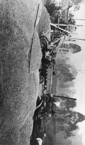
Photo: Road Making with Crusher
... Road Making in the Kiewa Valley...Ken Edmondson lived in the Kiewa Valley Road Making in the Kiewa Valley Ken Edmondson Black and white photo of a Crusher in the bushin the Kiewa Valley near Ken Edmondson Photo: Road Making with Crusher ...Road making with a crusher near Ken Edmondson's property.Ken Edmondson lived in the Kiewa ValleyBlack and white photo of a Crusher in the bushin the Kiewa Valley near Ken Edmondsonroad making in the kiewa valley, ken edmondson -
 Kiewa Valley Historical Society
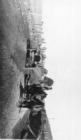
Photo: Making of Kiewa Valley Highway at Tawonga
... Kiewa Valley Historical Society Mount Beauty Information Centre 31 Bogong High Plains Rd Mt Beauty high-country The Kiewa Valley Highway was/is a major road along the Kiewa River ending at Mt Beauty the site of the S.E.C.V. town built for the construction of the K.H.E.S. Kiewa Valley Highway Road building Black and white photo with roofless old car beside two horses pulling a cart with man behind the cart. All coming towards the photographer on a road with paddocks on each side. Photo: Making ...The Kiewa Valley Highway was/is a major road along the Kiewa River ending at Mt Beauty the site of the S.E.C.V. town built for the construction of the K.H.E.S.Black and white photo with roofless old car beside two horses pulling a cart with man behind the cart. All coming towards the photographer on a road with paddocks on each side.kiewa valley highway, road building -
 Kiewa Valley Historical Society
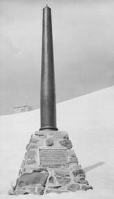
Photo: Memorial on the Staircase Spur Track, Mt Bogong
... Kiewa Valley Historical Society Mount Beauty Information Centre 31 Bogong High Plains Rd Mt Beauty high-country Mt Bogong is the highest mountain in Victoria. The Staircase Spur track to its top starts at Mountain Creek Road going through forest and continuing above the snow line to grass land. The weather can change very quickly with cloud and snow making ...Mt Bogong is the highest mountain in Victoria. The Staircase Spur track to its top starts at Mountain Creek Road going through forest and continuing above the snow line to grass land. The weather can change very quickly with cloud and snow making conditions dangerous. Large sepia photo of the Memorial in snow on the Staircase Spur Track on Mt Bogong. The Memorial has a plaque attached: Sacred to the Memory / of Georgine Gadsden / Edward Neave Welch / John McRae / who perished here during a blizzard / about August 2nd 1943staircase spur memorial, mt bogong -
 Kiewa Valley Historical Society
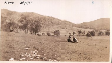
Black and white photograph of farmland, Kiewa, 25/8/38, circa 1938
... Kiewa Valley Historical Society Mount Beauty Information Centre 31 Bogong High Plains Rd Mt Beauty high-country This photograph was taken in August, 1938 at the time of road making in the area and some eight years prior to the establishment of Mt. ...This photograph was taken in August, 1938 at the time of road making in the area and some eight years prior to the establishment of Mt. Beauty township. The area was still being used for grazing, and the land was eventually acquired from the local land owners by the State Electricity Commission. The construction of the road, from Tawonga to the High Plains, was commenced in April of this year. This allowed men and heavy equipment to be transported to the work sites for the construction of the Kiewa Hydro Electric Scheme. An important photograph as it shows the upper Kiewa Valley as it was before the establishment of the town of Mt. Beauty. The land had been cleared of natural growth and has been used for grazing cattle. By 1946 housing construction had commenced for the new town of Mt. Beauty and by 1948 street construction in the southern part of the town was completed as far as Hill Street.A black and white photograph taken in the upper Kiewa Valley showing farmland with a group of three unidentified people sitting on the grass.Handwritten in black ink is the inscription 'Kiewa 25/8/1938'. In the right corner of the photograph has been stamped the number 6. On the back in a circle, some 14mm across, are the words 'Kodak Print'. The word Velox is also printed on the back.kiewa, mt. beauty, construction, grazing, secv -
 Wodonga & District Historical Society Inc
Book - The Kiewa Valley and Its Pioneers, Esther Temple, 1971
... Wodonga & District Historical Society Inc Hut 97, Bonegilla Migrant Experience, 132 Bonegilla Road Bonegilla the-murray history kiewa valley victorian pioneers kiewa valley tribes Historical handbook, includes brief section on Kiewa Valley tribes (Ya-itma-thang, Whroo, Kiewa, Unurring & Murramurrangbong), territory, shelters, fire, foods, including bogong moth, weapons, containers for water, fibre making for nets, stone tools, biographical details on Billy Elengeist & Queen Emily of the Murramurrangbong tribe. ...Historical handbook, includes brief section on Kiewa Valley tribes (Ya-itma-thang, Whroo, Kiewa, Unurring & Murramurrangbong), territory, shelters, fire, foods, including bogong moth, weapons, containers for water, fibre making for nets, stone tools, biographical details on Billy Elengeist & Queen Emily of the Murramurrangbong tribe.non-fictionHistorical handbook, includes brief section on Kiewa Valley tribes (Ya-itma-thang, Whroo, Kiewa, Unurring & Murramurrangbong), territory, shelters, fire, foods, including bogong moth, weapons, containers for water, fibre making for nets, stone tools, biographical details on Billy Elengeist & Queen Emily of the Murramurrangbong tribe.history kiewa valley, victorian pioneers, kiewa valley tribes -
 Falls Creek Historical Society
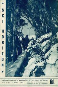
Journal - Ski-Horizon Vol 3 No 8
... making good progress with their lodges. Dawn is next to Toni St. Elmo Page 4 Albury Ski Club has increased its membership from 140 to 180. It now has its own transport bus known as "Jackson" Page 17 A letter from H. H. C. Williams stating the the Commission proposes to keep the Upper Kiewa Valley Road...making good progress with their lodges. Dawn is next to Toni St. Elmo Page 4 Albury Ski Club has increased its membership from 140 to 180. It now has its own transport bus known as "Jackson" Page 17 A letter from H. H. C. Williams stating the the Commission proposes to keep the Upper Kiewa Valley Road ...Ski-Horizon is the official journal of the Federation of Victorian Ski Clubs which began publication in 1949. The were 26 original member clubs which included Albury Ski Club, Bogong Ski Club, Myrtleford Ski Club, Tallangatta and District Ski Club and Wangaratta Ski Club. Two pioneers of Falls Creek, Tom Mitchell, M.L.A., and Martin Romuld were Vice-Presidents of the Federation.This Journal is significant because it documents the early development of skiing in Victoria.The journal features stories and events chronicling developments in Victoria and internationally. Items related to the Falls Creek Area in this publication include:- Page 3 Beechworth and Dawn Ski Clubs are making good progress with their lodges. Dawn is next to Toni St. Elmo Page 4 Albury Ski Club has increased its membership from 140 to 180. It now has its own transport bus known as "Jackson" Page 17 A letter from H. H. C. Williams stating the the Commission proposes to keep the Upper Kiewa Valley Road clear of snow as far as the Howman Dam Hostel only.albury ski club, beechworth ski club, dawn lodge, h. h. c. williams