Showing 4784 items matching "road plans"
-
 Sunshine and District Historical Society Incorporated
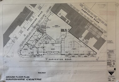
Plan - McKays Offices 2 Devonshire Road Redevelopment Plans
... McKays Offices 2 Devonshire Road Redevelopment Plans...Collection of proposed McKays Offices 2 Devonshire Road Redevelopment Plans...McKays Offices 2 Devonshire Road Redevelopment Plans...McKays Massey Harris Massey Ferguson Devonshire Road Sunshine McKays Offices 2 Devonshire Road Redevelopment Plans Collection of proposed McKays Offices 2 Devonshire Road Redevelopment Plans Plan McKays Offices 2 Devonshire Road Redevelopment Plans ...McKays Offices 2 Devonshire Road Redevelopment Plansh.v. mckays harris, h.v. mckays massey harris, massey ferguson, devonshire road, sunshine -
 Port Melbourne Historical & Preservation Society
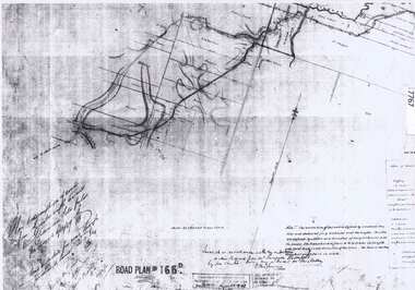
Map - Road plans for Fishermens Bend, R S Atkinson, 30 Apr 1946
... Road plans for Fishermens Bend...CRB Map outlining road plans for Fishermens Bend and including the site of the Commonwealth Aircraft Corporation, Aerodrome, General Holdens and C.S.R.I., 1946...Port Melbourne Historical & Preservation Society Port Melbourne Town Hall 333 Bay Street Port Melbourne melbourne transport - aviation and aerodrome industry - manufacturing fishermans bend CRB Map outlining road plans for Fishermens Bend and including the site of the Commonwealth Aircraft Corporation, Aerodrome, General Holdens and C.S.R.I., 1946 Map Road plans for Fishermens Bend R S Atkinson ...CRB Map outlining road plans for Fishermens Bend and including the site of the Commonwealth Aircraft Corporation, Aerodrome, General Holdens and C.S.R.I., 1946transport - aviation and aerodrome, industry - manufacturing, fishermans bend -
 Greensborough Historical Society
Document - Road Plan, Road acquisition, St Helena Road, 1859, 1889
... Road Plan...road plans...Road plan showing land acquisition for the road to Diamond Creek (NOT Diamond Creek Road), also known as Eltham Road and now known as St Helena Road....1 page. Copy of road plan...Copy of road plan Road acquisition, St Helena Road, 1859 Document Road Plan ...Road plan showing land acquisition for the road to Diamond Creek (NOT Diamond Creek Road), also known as Eltham Road and now known as St Helena Road.Shows the land through which St Helena Road runs, with original owners marked on plan.1 page. Copy of road planroad plans, st helena road greensborough, diamond creek -
Whitehorse Historical Society Inc.
Article, Concern At Road Plans, 15/01/1997 12:00:00 AM
... Concern At Road Plans...The Koonung Mullum Freeway Association calls for postponement of finalisation of 10 year north eastern regional road strategy until return of elected Councillors on 15th March 1997. Concern At Road Plans Article Article ...The Koonung Mullum Freeway Association calls for postponement of finalisation of 10 year north eastern regional road strategy.The Koonung Mullum Freeway Association calls for postponement of finalisation of 10 year north eastern regional road strategy until return of elected Councillors on 15th March 1997.The Koonung Mullum Freeway Association calls for postponement of finalisation of 10 year north eastern regional road strategy.freeways, koonung mullum forestway association, vicroads, city of whitehorse -
 Bacchus Marsh & District Historical Society
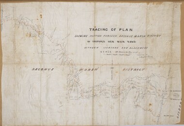
Map, Tracing of plan shewing portion through Bacchus Marsh District of proposed new Main Road between Gisborne and Blackwood
... Tracing of plan shewing portion through Bacchus Marsh District of proposed new Main Road between Gisborne and Blackwood......Road Plans...Road construction and planning was a primary function of the early local government authorities in rural and regional Victoria. ...A single page paper map showing the proposed route of a main road to be constructed between Gisborne and Blackwood. The map is pasted into a bound volume containing 76 maps or plans in total. ...Roads Road Plans Bacchus Marsh Victoria Maps Gisborne to Blackwood Main Road A single page paper map showing the proposed route of a main road to be constructed between Gisborne and Blackwood. ...Road construction and planning was a primary function of the early local government authorities in rural and regional Victoria. This plan is indicative of the sort of documentation which generated considerable public interest and comment in rural communities. The date of this plan is not clear. Newspaper articles in the Bacchus Marsh Express around 1869 contain numerous references to the proposed new road between Gisborne and Blackwood which suggests this plan may date from the late 1860s or early 1870s.A single page paper map showing the proposed route of a main road to be constructed between Gisborne and Blackwood. The map is pasted into a bound volume containing 76 maps or plans in total. High resolution digital image stored on BMDHS computer network. roads, road plans, bacchus marsh victoria maps, gisborne to blackwood main road -
 Bacchus Marsh & District Historical Society
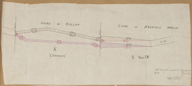
Map, Road plan deviation near Glenmore
... Road plan deviation near Glenmore...Road Plans...This plan shows a proposed deviation in the road near Glenmore. This is likely to have been the Bacchus Marsh to Ballan road. ...A single page paper map showing a plan for a road deviation near Glenmore Station. ...Glenmore is located 19 kilometers west of Bacchus Marsh. Road Plans Road Construction Glenmore Victoria Maps Old road colored Yellow, New road colored Pink A single page paper map showing a plan for a road deviation near Glenmore Station. ...This plan shows a proposed deviation in the road near Glenmore. This is likely to have been the Bacchus Marsh to Ballan road. The precise date of the plan has not been established. Proposed deviations to the road near Glenmore appear in reports in the Bacchus Marsh Express newspaper through many decades, especially in the 1870s and 1880s. Glenmore is located 19 kilometers west of Bacchus Marsh.A single page paper map showing a plan for a road deviation near Glenmore Station. Scale 5 chains to 1 inch. Date of production unknown. Circa 1860s-1890s. The map is pasted into a bound volume containing 76 maps or plans in total. High resolution digital image stored on BMDHS computer network. Old road colored Yellow, New road colored Pinkroad plans, road construction, glenmore victoria maps -
 Bendigo Historical Society Inc.
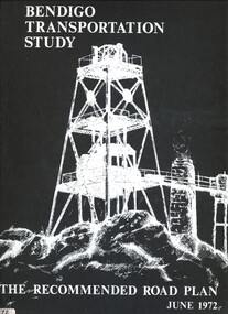
Book - BENDIGO TRANSPORTATION STUDY, 1972
... ...the recommended road plan...The Recommended Road Plan June 1972....The Recommended Road Plan June 1972. Book BENDIGO TRANSPORTATION STUDY ...Bendigo Transportation Study. The Recommended Road Plan June 1972.Rankine & Hill Consulting Engineers.bendigo, council, the recommended road plan, bendigo. -
Glen Eira Historical Society
Plan - KOOYONG ROAD, 179, CAULFIELD
... Road... Plans...A Handrawn, undated and unattributed plan of property at 179 Kooyong Road, Caulfield...Glen Eira Historical Society 965 Glen Huntly Rd Caulfield VIC 3162 melbourne A Handrawn, undated and unattributed plan of property at 179 Kooyong Road, Caulfield Caulfield Kooyong Road Plans Plan KOOYONG ROAD, 179, CAULFIELD ...A Handrawn, undated and unattributed plan of property at 179 Kooyong Road, Caulfieldcaulfield, kooyong road, plans -
 Sunshine and District Historical Society Incorporated
Administrative record - City of Sunshine - Commissioner Mr Alexander Alex George Gillon Collection 1976 - 1982 - Extraordinary business 11th December 1979, City of Sunshine, 11th December 1979
... Albans Road Planning Permit Application Amusement parlor and cafe Main Road West Planning Permit Application Place of Worship Vule Street Planning Permit Application Factory site Berkshire Road Plan of Subdivision Gooding Street Planning Permit Application Specialist stone services Geelong Road...Albans Road Planning Permit Application Amusement parlor and cafe Main Road West Planning Permit Application Place of Worship Vule Street Planning Permit Application Factory site Berkshire Road Plan of Subdivision Gooding Street Planning Permit Application Specialist stone services Geelong Road Foolscap sized document. ...Lease 2 -4 Burton Crescent Planning Permit Application Factory extension Raleigh Road Planning Permit Application Illuminated Sign City Place Planning Permit Application Factory with garage and carport display and sales McIntyre Road Planning Permit Application Extension of existing weighbridge, security officer's shelter Planning Permit Application Alterations to shops St. Albans Road Planning Permit Application Amusement parlor and cafe Main Road West Planning Permit Application Place of Worship Vule Street Planning Permit Application Factory site Berkshire Road Plan of Subdivision Gooding Street Planning Permit Application Specialist stone services Geelong Roadburton crescent, maribyrnong, raleigh road, city place, sunshine, mcintyre road, sunshine north, berkshire road, st. albans road, vule street, st. albans, main road west, geelong road, brooklyn, gooding street -
 Sunshine and District Historical Society Incorporated
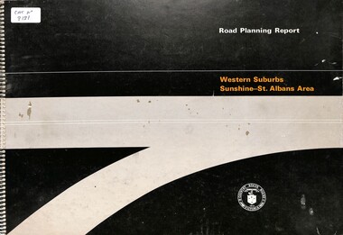
Document - Road Planning Report Western Suburbs Sunshine - St. Albans Area, Country Road Board Victoria, 1974
... Road Planning Report Western Suburbs Sunshine - St. ...Part of the Gwen Goedecke Collection Road Planning Report Western Suburbs Sunshine - St. ...Part of the Gwen Goedecke CollectionRoad Planning Report Western Suburbs Sunshine - St. Albans Area Country Road Board (CRB)Victoria -
 Sunshine and District Historical Society Incorporated
Administrative record - City of Sunshine - Commissioner Mr Alexander Alex George Gillon Collection 1976 - 1982 - Extraordinary Business 16th October 19, City of Sunshine, 16th October 1979
... Construction of Neale Road West of Oakwood Road Planning Permit Application Amusement Parlour Rosamond Road Maribrnong...Neale Road Deer Park Rosamond Road Maribyrnong Construction of Neale Road West of Oakwood Road Planning Permit Application Amusement Parlour Rosamond Road Maribrnong Foolscap sized document. ...Construction of Neale Road West of Oakwood Road Planning Permit Application Amusement Parlour Rosamond Road Maribrnongneale road, deer park, rosamond road, maribyrnong -
 Sunshine and District Historical Society Incorporated
Administrative record - City of Sunshine - Commissioner Mr Alexander Alex George Gillon Collection 1976 - 1982 - Matters from agenda and planning meeting 14th November 1978, City of Sunshine, 14th November 1978
... Planning Permit Extension to existing Wesleyan Church Devonshire Road Planning permit Flats Bardsley Street Dempster Park alterations to fence 41 Wright Street...City of Sunshine Alexander "Alex" George Gillon Wright Street Sunshine Dempster Park Phoenix Street Sunshine North Sunshine Wesleyan Church Devonshire Road Bardsley Street Sunshine West Planning Permit Extension to existing Wesleyan Church Devonshire Road Planning permit Flats Bardsley Street Dempster Park alterations to fence 41 Wright Street Foolscap sized document. ...Planning Permit Extension to existing Wesleyan Church Devonshire Road Planning permit Flats Bardsley Street Dempster Park alterations to fence 41 Wright Street city of sunshine, alexander "alex" george gillon, wright street, sunshine, dempster park, phoenix street, sunshine north, sunshine wesleyan church, devonshire road, bardsley street, sunshine west -
Whitehorse Historical Society Inc.
Pamphlet, Creating a New Strathdon Community, 2001
... A vision for the redevelopment of Strathdon's Jolimont Road site, contains Plans of Proposals for site development....Creating a New Strathdon Community: A vision for the redevelopment of Strathdon's Jolimont Road site, contains Plans of Proposals for site development....Whitehorse Historical Society Inc. 2-10 Deep Creek Road Mitcham melbourne A vision for the redevelopment of Strathdon's Jolimont Road site, contains Plans of Proposals for site development. ...Creating a New Strathdon Community.Creating a New Strathdon Community: A vision for the redevelopment of Strathdon's Jolimont Road site, contains Plans of Proposals for site development.Creating a New Strathdon Community.strathdon community, strathdon orchard, matheson, charles, matheson mary, aged people -
 Sunshine and District Historical Society Incorporated
Administrative record - City of Sunshine - Commissioner Mr Alexander Alex George Gillon Collection 1976 - 1982 - Extraordinary Business 12th December 1978, City of Sunshine, 12th December 1978
... Planning Permit Burke Street and Mullenger Road Planning Permit Extensions to the existing office and truck sales and service centre Geelong Road Planning Permit Nursing home and Matrons Residence Killara Street and Mernda Street Outer Ring Freeway St. ...Albans Keilor East McIntyre Road Sunshine North Warrs Road Fabian Court Maribyrnong Sunshine North Tennis Club Dempster Park Phoenix Street Highpoint West Childcare Centre Neale Road Deer Park Gregory Street Simmie Street Planning Permit Burke Street and Mullenger Road Planning Permit Extensions to the existing office and truck sales and service centre Geelong Road Planning Permit Nursing home and Matrons Residence Killara Street and Mernda Street Outer Ring Freeway St. ...Planning Permit Burke Street and Mullenger Road Planning Permit Extensions to the existing office and truck sales and service centre Geelong Road Planning Permit Nursing home and Matrons Residence Killara Street and Mernda Street Outer Ring Freeway St. Albans Road Sunshine to Webber Parade Planning Permit 40 - 42 McIntyre Road Planning Permit Lots 1 - 7 Warrs Road and lots 18 - 22 Fabian Court Lease of Highpoint West Child Care Centre Neale Road construction Greogry Street and Simmie Street One Way proposal Tennis Courts Dempster Park city of sunshine, alexander "alex" george gillon, burke street, mullenger road, braybrook, geelong road, brooklyn, killara street, mernda street, sunshine west, outer ring freeway, st. albans road, webber parade, st. albans, keilor east, mcintyre road, sunshine north, warrs road, fabian court, maribyrnong, sunshine north tennis club, dempster park, phoenix street, highpoint west childcare centre, neale road, deer park, gregory street, simmie street -
Whitehorse Historical Society Inc.
Map, Survey for road from Doncaster to Ringwood, 01/03/1867
... Survey in County of Bourke, Road Plan no. 390, showing early routes of Doncaster, Whitehorse and Mitcham Roads. ...Survey in County of Bourke, Road Plan no. 390, showing early routes of Doncaster, Whitehorse and Mitcham Roads. ...Survey in County of Bourke, Road Plan no. 390, showing early routes of Doncaster, Whitehorse and Mitcham Roads.Survey in County of Bourke, Road Plan no. 390, showing early routes of Doncaster, Whitehorse and Mitcham Roads. Measurement in chains. Surveyor: Thomas E. Rawlinson.Survey in County of Bourke, Road Plan no. 390, showing early routes of Doncaster, Whitehorse and Mitcham Roads. parish of nunawading, parish of bulleen, whitehorse road mitcham, doncaster road, doncaster east, mitcham road mitcham -
 Sunshine and District Historical Society Incorporated
Administrative record - City of Sunshine - Commissioner Mr Alexander Alex George Gillon Collection 1976 - 1982 - Report of committee meetings 12th December 1978, City of Sunshine, 12th December 1978
... Lease 2 - 4 Burton Crescent Subdivision of Land Fairbairn Road Proposed Rezoning of Land Laurel Street Planning Permit Bank extension Hampshire Road Planning Permit hairdressing Salon Hampshire Road Planning Permit factory Cromer Avenue Planning Permit Community Health Centre Andrea Street Planning Permit Educational Establishment Navigator Street Planning Permit Additions to existing church Ballarat Road Deer Park Planning Permit Entertainment Complex (Malibu grand Prix) Ballarat Road and Geelong Road Planning Permit Place of Assembly Hutchinson Street Construction of Justin Road Construction of laneway rear of Sydney Street between King Edward Avenue and Ridley street Planning Permit Flats Warrs Road and Fabian Court...Albans Hampshire Road Sunshine Cromer Avenue Sunshine North Andrea Street Navigator Street Ballarat Road Deer Park Geelong Road Braybrook Brooklyn Hutchinson Street Albion Justin Road Sydney Street King Edward Avenue Warrs Road Fabian Court Lease 2 - 4 Burton Crescent Subdivision of Land Fairbairn Road Proposed Rezoning of Land Laurel Street Planning Permit Bank extension Hampshire Road Planning Permit hairdressing Salon Hampshire Road Planning Permit factory Cromer Avenue Planning Permit Community Health Centre Andrea Street Planning Permit Educational Establishment Navigator Street Planning Permit Additions to existing church Ballarat Road Deer Park Planning Permit Entertainment Complex (Malibu grand Prix) Ballarat Road and Geelong Road Planning Permit Place of Assembly Hutchinson Street Construction of Justin Road Construction of laneway rear of Sydney Street between King Edward Avenue and Ridley street Planning Permit Flats Warrs Road and Fabian Court Foolscap sized document. ...Lease 2 - 4 Burton Crescent Subdivision of Land Fairbairn Road Proposed Rezoning of Land Laurel Street Planning Permit Bank extension Hampshire Road Planning Permit hairdressing Salon Hampshire Road Planning Permit factory Cromer Avenue Planning Permit Community Health Centre Andrea Street Planning Permit Educational Establishment Navigator Street Planning Permit Additions to existing church Ballarat Road Deer Park Planning Permit Entertainment Complex (Malibu grand Prix) Ballarat Road and Geelong Road Planning Permit Place of Assembly Hutchinson Street Construction of Justin Road Construction of laneway rear of Sydney Street between King Edward Avenue and Ridley street Planning Permit Flats Warrs Road and Fabian Court city of sunshine, alexander "alex" george gillon, burton crescent, maribyrnong, fairbairn road, sunshine west, laurel street, st. albans, hampshire road, sunshine, cromer avenue, sunshine north, andrea street, navigator street, ballarat road, deer park, geelong road, braybrook, brooklyn, hutchinson street, albion, justin road, sydney street, king edward avenue, warrs road, fabian court -
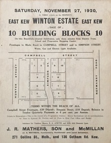 Kew Historical Society Inc
Plan - Subdivision Plan, Winton Estate, East Kew : Sale of 10 Building Blocks, 1920
... road - kew...subdivision plans - east kew...These early plans were assembled by a local firm, Jas R Mather & McMillan, which had an office in Cotham Road. ...These early plans were assembled by a local firm, Jas R Mather & McMillan, which had an office in Cotham Road. ...The Kew Historical Society's map collection includes a substantial number of real estate subdivision plans, mainly of Kew but also of surrounding suburbs in Melbourne. Most of the subdivision plans date from the 1920s and 1930s when the districts old homes and local farmland were being split up to accommodate residential growth in the postwar period. These early plans were assembled by a local firm, Jas R Mather & McMillan, which had an office in Cotham Road. Many of the plans, and sometimes photos, were annotated by the agents.Subdivision plans are historically important documents used as evidence for the growth of suburbs in Australia. They frequently provide information about when the land was sold as well as evidence relating to surveyors and real estate and financial agents. The numerous subdivision plans in the Kew Historical Society's collection represent working documents, ranging from the initial sketches made in planning a subdivision to printed plans on which auctioneers or agents listed the prices for which individual lots were sold. In a number of cases, the reverse of a subdivision plan in the collection includes a photograph of a house that was also for sale by the agent. These photographs provide significant heritage information relating house design and decoration, fencing and household gardens.The photograph may also be aesthetically significant depending on the importance of the photographic atelier.Subdivision plan for the so-called Winton Estate in East Kew. The Estate comprised 10 lots facing Simpson Street and Campbell Street. The estate was auctioned by Jas. R. Mathers, Son and McMillan. campbell street, simpson street, hunter street, normanby road - kew, subdivision plans - east kew, subdivision plans - kew -
Glen Eira Historical Society
Plan - Centre Road, 473A-479, Bentleigh
... Road... Bentleigh... Plans...Two copies of a one page printed advertisement for the auction of six shops on Centre Road, Bentleigh near Jasper Road to be held on 07/03/1950. The advertisement includes a plan (51mm x 127mm) of the sites. ...Meldrum W Centre Road Bentleigh Plans Advertisements shops Plan Centre Road, 473A-479, Bentleigh ...Two copies of a one page printed advertisement for the auction of six shops on Centre Road, Bentleigh near Jasper Road to be held on 07/03/1950. The advertisement includes a plan (51mm x 127mm) of the sites. Current address for these appears to be 473A-479 Centre Road, Bentleigh.meldrum w, centre road, bentleigh, plans, advertisements, shops -
 Whitehorse Historical Society Inc.
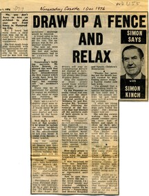
Article, Draw up a fence and relax, 1976
... Including musings on council requirements for fence plans, road traffic problems in Vermont South and the meanings of the acronym NADRASCA....Column by journalist Simon Kinch, including musings on council requirements for fence plans, road traffic problems in Vermont South and the meanings of the acronym NADRASCA...Whitehorse Historical Society Inc. 2-10 Deep Creek Road Mitcham melbourne Including musings on council requirements for fence plans, road traffic problems in Vermont South and the meanings of the acronym NADRASCA. ...Column by journalist Simon Kinch.Column by journalist Simon Kinch, including musings on council requirements for fence plans, road traffic problems in Vermont South and the meanings of the acronym NADRASCAColumn by journalist Simon Kinch.fences, vermont south, nadrasca -
 Sunshine and District Historical Society Incorporated
Administrative record - City of Sunshine - Commissioner Mr Alexander Alex George Gillon Collection 1976 - 1982 - Matters Arising From Agenda Committee 9th June 1980, City of Sunshine, 9th June 1980
... Planning Permit Application Extractive Industry McIntyre Road Planning Permit Application Detached house Carroll Street Planning Permit Application Residential subdivision and industrial use St. ...McIntyre Road Sunshine North Carroll Street Deer Park St. Albans Planning Permit Application Extractive Industry McIntyre Road Planning Permit Application Detached house Carroll Street Planning Permit Application Residential subdivision and industrial use St. ...Planning Permit Application Extractive Industry McIntyre Road Planning Permit Application Detached house Carroll Street Planning Permit Application Residential subdivision and industrial use St. Albans and Sunshine Northmcintyre road, sunshine north, carroll street, deer park, st. albans -
 City of Moorabbin Historical Society (Operating the Box Cottage Museum)
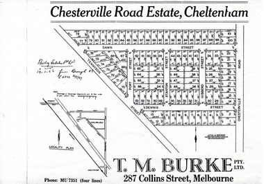
Flyer - Chesterville Road Estate, Cheltenham, 1947
... Chesterville Road Estate, Cheltenham - plan of subdivision...Example of the progress of the Municipality of Moorabbin Tennyson Street Port Street Dennis Street Station Street Dawn Street Hubbard Street Chesterville Road Cheltenham real estate auction Chesterville Road Estate, Cheltenham - plan of subdivision Photocopy of advertising flyer for sale of real estate sales - plan of building blocks for sale Flyer Chesterville Road Estate, Cheltenham ...Chesterville Road Estate, consisting of 101 building lots, was sold by private sale in late 1947.Example of the progress of the Municipality of MoorabbinPhotocopy of advertising flyer for sale of real estate sales - plan of building blocks for saleChesterville Road Estate, Cheltenham - plan of subdivisiontennyson street, port street, dennis street, station street, dawn street, hubbard street, chesterville road, cheltenham, real estate, auction -
Whitehorse Historical Society Inc.
Map, Burwood Road, Box Hill City, 15/02/1952 12:00:00 AM
... Between Greenwood Street and Middleborough Road. Marked as Survey Plan No 5442....Plan of subdivision of 19 blocks in Burwood Road, Burwood between Greenwood Street and Middleborough Road. ...Whitehorse Historical Society Inc. 2-10 Deep Creek Road Mitcham melbourne Between Greenwood Street and Middleborough Road. Marked as Survey Plan No 5442. Land Subdivision Burwood Road Burwood Greenwood Street Burwood Middleborough Road Burwood Plan of subdivision of 19 blocks in Burwood Road, Burwood. ...Plan of subdivision of 19 blocks in Burwood Road, Burwood.Plan of subdivision of 19 blocks in Burwood Road, Burwood between Greenwood Street and Middleborough Road. Marked as Survey Plan No 5442.Plan of subdivision of 19 blocks in Burwood Road, Burwood. land subdivision, burwood road, burwood, greenwood street, burwood, middleborough road, burwood -
 Sunshine and District Historical Society Incorporated
Administrative record - City of Sunshine - Commissioner Mr Alexander Alex George Gillon Collection 1976 - 1982 - Attachments for the ordinary meeting 25th March 1980, City of Sunshine, 25th March 1979
... Tallintyre Road Child Care Centre 56 Tallintyre Road Sunshine West Notice of Appeal Boundary Road corner Fitzgerald Road Planning Application Extensions and alterations existing fruit and vegetable whole and retails premise Mitchell Street Maidstone...Tallintyre Road Child Care Tallintyre Road Sunshine West Boundary Road Fitzgerald Road Derrimut Mitchell Street Maidstone Tallintyre Road Child Care Centre 56 Tallintyre Road Sunshine West Notice of Appeal Boundary Road corner Fitzgerald Road Planning Application Extensions and alterations existing fruit and vegetable whole and retails premise Mitchell Street Maidstone Foolscap sized document. ...Tallintyre Road Child Care Centre 56 Tallintyre Road Sunshine West Notice of Appeal Boundary Road corner Fitzgerald Road Planning Application Extensions and alterations existing fruit and vegetable whole and retails premise Mitchell Street Maidstonetallintyre road child care, tallintyre road, sunshine west, boundary road, fitzgerald road, derrimut, mitchell street, maidstone -
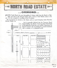 City of Moorabbin Historical Society (Operating the Box Cottage Museum)
Flyer - North Road Estate, Ormond
... North Road Estate, Ormond - plan of subdivision.36...Example of the progress of the Municipality of Moorabbin North Road Wicklow St Leinster St ormond real estate North Road Estate, Ormond - plan of subdivision.36 Advertising flyer for auction of real estate sales - plan of building blocks for sale Flyer North Road Estate, Ormond ...At the end of World War One, there was a renewed interest in residential land and a number of estates opened up in the Municipality of Moorabbin.Example of the progress of the Municipality of MoorabbinAdvertising flyer for auction of real estate sales - plan of building blocks for saleNorth Road Estate, Ormond - plan of subdivision.36north road, wicklow st, leinster st, ormond, real estate -
Whitehorse Historical Society Inc.
Document, Nunawading South State School
... Photocopies of photos of the land before and during building. Road Plan. Notice from Native Plants Preservation Society....Photocopies of photos of the land before and during building. Road Plan. Notice from Native Plants Preservation Society. ...Documents relating to purchase of land to build Nunawading South State School. Land purchased from K.E. & L.A. Jones. Photocopies of photos of the land before and during building. Road Plan. Notice from Native Plants Preservation Society.nunawading south state school no. 4808, k.e. & l.a. jones, victoria. education department, native plants preservation society of victoria -
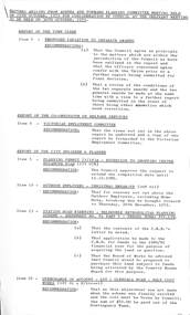
 Sunshine and District Historical Society Incorporated
Document - Sunshine District Road Proposed Improvements 1987, 25th February 1987
... Executive Committee 25.2.87 Page 13|Report of the City Planner|Sunshine District Centre Road Improvements Plan A...This item was part of the Gwen Goedecke donation Executive Committee 25.2.87 Page 13|Report of the City Planner|Sunshine District Centre Road Improvements Plan A Extract from the City of Sunshine Executive Committee Report 25th February 1987 Page 13 Document Sunshine District Road Proposed Improvements 1987 ...This item was part of the Gwen Goedecke donationExecutive Committee 25.2.87 Page 13|Report of the City Planner|Sunshine District Centre Road Improvements Plan A -
 Sunshine and District Historical Society Incorporated
Administrative record - City of Sunshine - Commissioner Mr Alexander Alex George Gillon Collection 1976 - 1982 - Matters Arising Agenda And Forward Committee 30th October 1979, City of Sunshine, 29th October 1979
... Station Road Widing Planning Permit Extensions to shopping centre Rosamond Road Princess Street Arcade car parking...Albans Station Road Widing Planning Permit Extensions to shopping centre Rosamond Road Princess Street Arcade car parking Foolscap sized document. ...Station Road Widing Planning Permit Extensions to shopping centre Rosamond Road Princess Street Arcade car parkingstation road, deer park, highpoint west, rosamond road, maribyrnong, princess street, st. albans -
 Sunshine and District Historical Society Incorporated
Administrative record - City of Sunshine - Commissioner Mr Alexander Alex George Gillon Collection 1976 - 1982 - Extraordinary business 14th October 1980, City of Sunshine, 14th October 1980
... Planning Permit Application Illuminated Signs 237 Hampshire Road Sunshine Planning Permit Application Boiler House Extensions 465 Somerville Road Footscray West Planning Permit Application Commercial Vehicle Park Lot 1 Geelong Road Planning Permit Application Flats Lot 472 Henry Street Sunshine West Planning Permit Application Display Homes and Associated Car Park Furlong Road St. ...Albans Station Road Deer Park Warrs Road Maribyrnong Planning Permit Application Illuminated Signs 237 Hampshire Road Sunshine Planning Permit Application Boiler House Extensions 465 Somerville Road Footscray West Planning Permit Application Commercial Vehicle Park Lot 1 Geelong Road Planning Permit Application Flats Lot 472 Henry Street Sunshine West Planning Permit Application Display Homes and Associated Car Park Furlong Road St. ...Planning Permit Application Illuminated Signs 237 Hampshire Road Sunshine Planning Permit Application Boiler House Extensions 465 Somerville Road Footscray West Planning Permit Application Commercial Vehicle Park Lot 1 Geelong Road Planning Permit Application Flats Lot 472 Henry Street Sunshine West Planning Permit Application Display Homes and Associated Car Park Furlong Road St. Albans Planning Permit Application Sky Sign corner Geelong Road and Francis Street Brooklyn Planning Permit Application Flats 185A Main Road West Planning Permit Application Additional to existing petrol filling station corner St. Albans Road and Percy Street St. Albans Station Road Widening Acquisition of 88 Station Road Deer Park Warrs Road Private Street Scheme Maribyrnong Height of Sunblind 254 Hampshire Road Sunshinehampshire road, sunshine, somerville road, footscray west, geelong road, brooklyn, henry street, sunshine west, furlong road, francis street, main road west, st. albans road, percy street, st. albans, station road, deer park, warrs road, maribyrnong -
 Kew Historical Society Inc
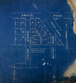
Plan - Subdivision Plan, Argyle Road, Heather Grove, Victor Avenue, Kew, c.1937
... These early plans were assembled by a local firm, Jas R Mather & McMillan, which had an office in Cotham Road. ...Undated blue subdivision plan in Kew of 14 lots facing Argyle Road, Heather Grove and Victor Road. ...These early plans were assembled by a local firm, Jas R Mather & McMillan, which had an office in Cotham Road. ...The Kew Historical Society's map collection includes a substantial number of real estate subdivision plans, mainly of Kew but also of surrounding suburbs in Melbourne. Most of the subdivision plans date from the 1920s and 1930s when the districts old homes and local farmland were being split up to accommodate residential growth in the postwar period. These early plans were assembled by a local firm, Jas R Mather & McMillan, which had an office in Cotham Road. Many of the plans, and sometimes photos, were annotated by the agents.Subdivision plans are historically important documents used as evidence for the growth of suburbs in Australia. They frequently provide information about when the land was sold as well as evidence relating to surveyors and real estate and financial agents. The numerous subdivision plans in the Kew Historical Society's collection represent working documents, ranging from the initial sketches made in planning a subdivision to printed plans on which auctioneers or agents listed the prices for which individual lots were sold. In a number of cases, the reverse of a subdivision plan in the collection includes a photograph of a house that was also for sale by the agent. These photographs provide significant heritage information relating house design and decoration, fencing and household gardens.The photograph may also be aesthetically significant depending on the importance of the photographic atelier.Undated blue subdivision plan in Kew of 14 lots facing Argyle Road, Heather Grove and Victor Road. The Plan identifies Tuxen & Miller as the surveyors. [Formerly catalogued as MAP.0059]subdivision plans - kew, argyle road - kew, heather grove - kew, victor avenue - kew -
 Eltham District Historical Society Inc
Book, A Review and Appraisal of the Diamond Creek to Ringwood Study, volume 2, working paper, by Loder and Bayly, 1979
... This report is a review and appraisal of the Outer Ring Road Study Diamond Creek to Ringwood prepared for The Road Planning Liaison Committee by the Joint Road Planning Group for the The City of Doncaster & Templestowe and The Shire of Eltham by Loder & Bayly Planning & Engineering Consultants. ...This report is a review and appraisal of the Outer Ring Road Study Diamond Creek to Ringwood prepared for The Road Planning Liaison Committee by the Joint Road Planning Group for the The City of Doncaster & Templestowe and The Shire of Eltham by Loder & Bayly Planning & Engineering Consultants. ...Volume 2: Working papers. This report is a review and appraisal of the Outer Ring Road Study Diamond Creek to Ringwood prepared for The Road Planning Liaison Committee by the Joint Road Planning Group for the The City of Doncaster & Templestowe and The Shire of Eltham by Loder & Bayly Planning & Engineering Consultants. "This paper attempts to set a framework for an evaluation of the recommended road link between Diamond Creek and Ringwood." Various perspectives are examined. Includes fold out maps.91 p, maps, 27 cm.melbourne ring road, roads, freeways