Showing 5334 items matching "road sign"
-
 Bendigo Historical Society Inc.
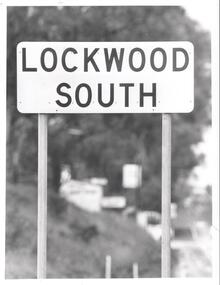
Photograph - BENDIGO ADVERTISER COLLECTION: ROAD SIGN OF LOCKWOOD SOUTH, 10/08/1993
... BENDIGO ADVERTISER COLLECTION: ROAD SIGN OF LOCKWOOD SOUTH...Road sign of Lockwood South....History House 11 Mackenzie Street Bendigo goldfields REGION Small towns Lockwood South Bill Hawkins Road sign of Lockwood South. Photograph BENDIGO ADVERTISER COLLECTION: ROAD SIGN OF LOCKWOOD SOUTH ...Road sign of Lockwood South.Bill Hawkinsregion, small towns, lockwood south -
 Puffing Billy Railway
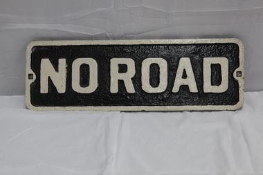
No Road - End of platform sign
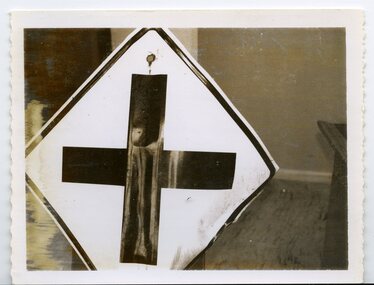
... No Road - End of platform sign......no road sign...Historic - Railway - No Road Plate Sign ...No Road Plate Sign Long rectangular plate that has been painted black and white with the words "no road" written across it. made of cast metal...Puffing Billy Railway 1 old monbulk road Belgrave yarra-valley-and-the-dandenong-ranges Historic - Railway - No Road Plate Sign Historic - Railway - No Road Plate Sign puffing billy sign plate no road sign "No Road" No Road Plate Sign Long rectangular plate that has been painted black and white with the words "no road" written across it. made of cast metal No Road - End of platform sign ...Historic - Railway - No Road Plate Sign Historic - Railway - No Road Plate Sign No Road Plate Sign Long rectangular plate that has been painted black and white with the words "no road" written across it. made of cast metal"No Road"puffing billy, sign, plate, no road sign -
 Ringwood and District Historical Society
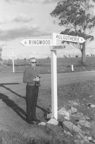
Photograph, Hampshire, England. Road sign indicating distance to Ringwood. Undated
... Hampshire, England. Road sign indicating distance to Ringwood. Undated....Catalogue card reads, "Hampshire, England. Road sign indicating distance to Ringwood". ...No date Hampshire, England. Road sign indicating distance to Ringwood. Undated. ...Catalogue card reads, "Hampshire, England. Road sign indicating distance to Ringwood". Man is unidentified. No date -
 National Wool Museum
Photograph, Collins Bros Mill Pty Ltd, Physician Blanket Road Sign, Unknown
... Physician Blanket Road Sign...Black and white photograph showcasing the Physician Blanket advertising road sign above a two story building in a landscape format. ...Physician Blanket Road Sign Photograph Photograph Collins Bros Mill Pty Ltd ...Advertising sign for the Physician Blankets Manufactured by Collins Bros Pty Ltd. Black and white photograph showcasing the Physician Blanket advertising road sign above a two story building in a landscape format. The road and moving cars are in the foreground.Front centre - Physician Chillproof Blankets. Sign Rear - Physician Brisbane (?) (?) Signwool, woollen mills, wool manufacture -
 Greensborough Historical Society
Slide - Photograph, John Ramsdale, Gorge Road sign: Slide 55, 1990s
... Gorge Road sign: Slide 55...Photograph shows house with anti-Plenty Gorge Park sign, Gorge Road South Morang...Colour photograph scanned from slide. Gorge Road sign: Slide 55 Slide Photograph John Ramsdale ...Photograph shows house with anti-Plenty Gorge Park sign, Gorge Road South MorangPart of the John Ramsdale collection of slides and audio visual material.Colour photograph scanned from slide.No maker's marks. No caption on slide.plenty gorge, plenty gorge metropolitan park, melbourne and metropolitan board of works -
 City of Whittlesea
Sign (item), Crossing Road Sign damaged by vandals, located at corner Bridge Inn Road and Reids Lane Doreen, 19/6/63
... Crossing Road Sign damaged by vandals, located at corner Bridge Inn Road and Reids Lane Doreen, 19/6/63,...City of Whittlesea 25 Ferres Boulevard South Morang melbourne sign sign, colour Crossing Road Sign damaged by vandals, located at corner Bridge Inn Road and Reids Lane Doreen, 19/6/63, Sign Sign ...sign -
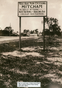 Whitehorse Historical Society Inc.
Photograph - Black and white photograph, Whitehorse Road Sign Mitcham, C1940s
... Whitehorse Road Sign Mitcham...Sign on south side of Whitehorse Road opposite Dunlavin Road, Mitcham, looking east. ...Whitehorse Historical Society Inc. 2-10 Deep Creek Road Mitcham melbourne advertising signs whitehorse road mitcham dunlavin road Sign on south side of Whitehorse Road opposite Dunlavin Road, Mitcham, looking east. ...Sign on south side of Whitehorse Road opposite Dunlavin Road, Mitcham, looking east. Early 1940s. Note in 1870 the area was known as Air Hill. Center of shot shows shop on west side of what later became Alexander Street and further east house on the corner of Peel Street. These signs are very similar to those erected in nearby Vermont.advertising signs, whitehorse road, mitcham, dunlavin road -
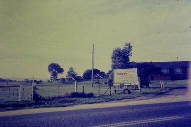
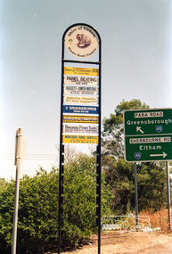
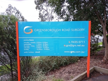 Greensborough Historical Society
Photograph - Digital image, Marilyn Smith, Greensborough Road Surgery Sign, 10/07/2016
... Greensborough Road Surgery Sign...Greensborough Historical Society 34A Glenauburn Road Lower Plenty Lower Plenty melbourne The Greensborough Road Surgery moved to this location in 1985 in response to increased demand for services. greensborough road surgery medical centre Greensborough Road Surgery Sign Photograph - Digital image Marilyn Smith ...The Greensborough Road Surgery moved to this location in 1985 in response to increased demand for services.greensborough road surgery, medical centre -
 Eltham District Historical Society Inc
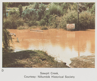
Work on paper (Sub-Item) - Photograph, Sawpit Creek in flood, Diamond Creek Township, 8 April 1977
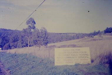
... ...road sign...Sawpit Creek near the Diamond Creek in flood at Diamond Creek township, 8 April 1977 A road sign reads" DANGER ROAD FLOODED AFTER HEAVY RAIN OBSERVE MARKERS" Nillumbik Historical Society collection...Sawpit Creek near the Diamond Creek in flood at Diamond Creek township, 8 April 1977 A road sign reads" DANGER ROAD FLOODED AFTER HEAVY RAIN OBSERVE MARKERS" Nillumbik Historical Society collection flood diamond creek flooding nillumbik historical society give way sawpit creek campbell street watkins street Danger road sign Image printed on A4 page from 04997 Diamond Creek Basin Study, 1980 Sawpit Creek in flood, Diamond Creek Township, 8 April 1977 Work on paper Photograph ...Colour photograph. Sawpit Creek near the Diamond Creek in flood at Diamond Creek township, 8 April 1977 A road sign reads" DANGER ROAD FLOODED AFTER HEAVY RAIN OBSERVE MARKERS" Nillumbik Historical Society collectionflood, diamond creek, flooding, nillumbik historical society, give way, sawpit creek, campbell street, watkins street, danger, road sign -
![Sign, Shire of Eltham, St Faiths Road, Shire of Eltham [street sign], 1960s](/media/collectors/4f729f5697f83e03086015b8/items/67db6caab13536720ddc4bb9/item-media/67f21a5be76666667ba86b1f/item-fit-380x285.jpg?cb=6) Greensborough Historical Society
Greensborough Historical SocietySign, Shire of Eltham, St Faiths Road, Shire of Eltham [street sign], 1960s
... St Faiths Road, Shire of Eltham [street sign]......road sign...Road sign pre 1994 of St Faiths Road, Montmorency, formerly in the Shire of Eltham. ...Greensborough Historical Society 34A Glenauburn Road Lower Plenty Lower Plenty melbourne Road sign pre 1994 of St Faiths Road, Montmorency, formerly in the Shire of Eltham. ...Road sign pre 1994 of St Faiths Road, Montmorency, formerly in the Shire of Eltham. This early sign does not have the Shire of Eltham 'branding' of later signs. Following the redistribution of local government areas in 1994, St Faiths Road was allocated to the City of Banyule.Double Sided Metal sign, white with black writing shire of eltham, road sign, st faiths road montmorency -
 Eltham District Historical Society Inc
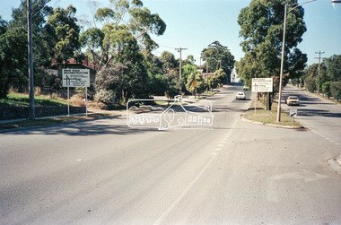
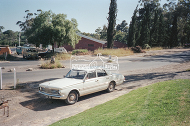
Negative - Photograph, Main Road, Eltham, c.Dec. 1983
... ...road sign...Road sign advising of proposed reconstruction works of Main Road to install a roundabout at Mount Pleasant Road. ...Eltham District Historical Society Inc 728 Main Rd Eltham melbourne Road sign advising of proposed reconstruction works of Main Road to install a roundabout at Mount Pleasant Road. ...Road sign advising of proposed reconstruction works of Main Road to install a roundabout at Mount Pleasant Road. Traffic to Lower Plenty and Templestowe to be diverted down Bridge Street (and Bolton Street) effective January 1984. The proposed roundabout did not proceed. Instead traffic islands on Mount Pleasant Road were installed in place of temporary blocked out islands.Film - Kodak CM 400 5079 7 strips, 26 framesinfrastructure, roads, road construction, roundabout, road sign, main road, mount pleasant road -
 National Vietnam Veterans Museum (NVVM)
Artwork, other - Painting, on velvet
... He is holding a road sign. "Tobey" on his right pocket....On helmet: FAID-V ( written in pen) . On road sign: HQ69th Sig B.N. VIETNAM printed in white on top of disc....He is holding a road sign. "Tobey" on his right pocket. Artwork, other Painting, on velvet ...Round black velvet disc with caricature-style image of a soldier in US Army battle dress with a rifle over his left shoulder painted on it . Flags of America, Vietnam and Korea are in the background. He is holding a road sign. "Tobey" on his right pocket.On helmet: FAID-V ( written in pen) . On road sign: HQ69th Sig B.N. VIETNAM printed in white on top of disc.plaque, america, craft, art, souvenir, us soldier -
 Eltham District Historical Society Inc
Photograph, Main Road, Lower Plenty - sign to Golf Club Hotel
... Main Road, Lower Plenty - sign to Golf Club Hotel...Eltham District Historical Society Inc 728 Main Rd Eltham melbourne infrastructure shire of eltham infrastructure lower plenty Golf Club Hotel Main Road Black and white photograph Main Road, Lower Plenty - sign to Golf Club Hotel Photograph ...Black and white photographinfrastructure, shire of eltham infrastructure, lower plenty, golf club hotel, main road -
 Vision Australia
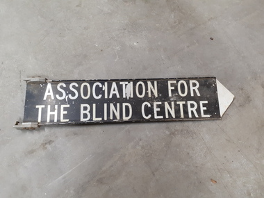
Sign - Image, Street sign for the Association for the Blind
... Black and white road sign...Vision Australia 454 Glenferrie Road Kooyong melbourne A metal street sign with a black background and white writing and a white pointing tip at the end, indicating which direction the Association for the Blind was located. association for the blind Nameplates Association for the Blind Centre Black and white road sign Street sign for the Association for the Blind Sign Image ...A metal street sign with a black background and white writing and a white pointing tip at the end, indicating which direction the Association for the Blind was located.Black and white road signAssociation for the Blind Centreassociation for the blind, nameplates -
 Eltham District Historical Society Inc
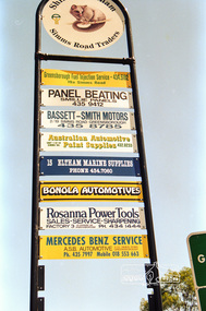
Photograph, Sign, Simms Road Traders, Shire of Eltham, Briar Hill, c.1992, 1992c
... Sign, Simms Road Traders, Shire of Eltham, Briar Hill, c.1992...Briar Hill, shire of eltham, Sign, Signs, Simms Road Traders...Eltham District Historical Society Inc 728 Main Rd Eltham melbourne Briar Hill, shire of eltham, Sign, Signs, Simms Road Traders Fuji 100 Roll of 35mm colour negative film, 7 strips Sign, Simms Road Traders, Shire of Eltham, Briar Hill, c.1992 Photograph ...Roll of 35mm colour negative film, 7 strips Fuji 100briar hill, shire of eltham, sign, signs, simms road traders -
 Eltham District Historical Society Inc
Photograph, Sign, Simms Road Traders, Shire of Eltham, Briar Hill, c.1992, 1992c
... Sign, Simms Road Traders, Shire of Eltham, Briar Hill, c.1992...briar hill, shire of eltham, sign, signs, simms road traders...Eltham District Historical Society Inc 728 Main Rd Eltham melbourne briar hill, shire of eltham, sign, signs, simms road traders Fuji 100 Roll of 35mm colour negative film, 7 strips Sign, Simms Road Traders, Shire of Eltham, Briar Hill, c.1992 Photograph ...Roll of 35mm colour negative film, 7 strips Fuji 100briar hill, shire of eltham, sign, signs, simms road traders -
 Greensborough Historical Society
Slide - Photograph, John Ramsdale, Sign - Gorge Road: Slide 76, 1990s
... Sign - Gorge Road: Slide 76...Photograph shows an anti- Plenty Gorge Park sign in Gorge Road South Morang...Colour photograph scanned from slide. Sign - Gorge Road: Slide 76 Slide Photograph John Ramsdale ...Photograph shows an anti- Plenty Gorge Park sign in Gorge Road South MorangPart of the John Ramsdale collection of slides and audio visual material.Colour photograph scanned from slide.No maker's marks. No caption on slide.plenty gorge, plenty gorge metropolitan park, melbourne and metropolitan board of works -
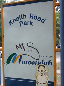 Ringwood and District Historical Society
Photograph, Knaith Road Park, Ringwood East, sign in January 2007
... Knaith Road Park, Ringwood East, sign in January 2007...Ringwood and District Historical Society 125A Warrandyte Road Ringwood North melbourne City of Maroondah Knaith Road Park, Ringwood East, sign in January 2007 Photograph ...City of Maroondah -
 Eltham District Historical Society Inc
Photograph (Item) - Negative, Samantha Robertson, Eltham Community Photographic Survey Entry, 1988
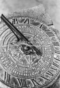
... ...Main Road...Sign...It is a time capsule of life in the 1980s of this urban and rural municipality in Melbourne's north. shire of eltham archives Bicentennial Project Eltham Eltham Community Photographic Survey Samantha Robertson Series 35 Film - Ilford XP1 400 Scan - 35mm negative Sundial Eltham Trestle Bridge Central Park Panther Place Graffiti Eltham Senior Citizens Centre Eltham Shire Office Eucalyptus tree Main Road Sign Arthur Street Commercial Place Eltham Village Safeway Carpark Black and white 35mm film strip - Ilford XP1 400 11 frames Eltham Community Photographic Survey Entry Photograph Negative Samantha Robertson ...Samantha Robertson 1988 Entrant No. 1 Ref: Series 34 Items 1, 2, 42-45 The images in this record were not selected for inclusion. SHIRE OF ELTHAM COMMUNITY PHOTOGRAPHIC SURVEY Photography is an artform which many of us practice, sometimes purely for artistic pursuit, sometimes to record the people and events in our lives. In 1988, as part of a local Bicentennial project, the Shire of Eltham conducted the Eltham Community Photographic Survey. Up to 100 entries were to be selected by a panel of photographers for entry into the Eltham Photographic Survey Exhibition. Entries had to be submitted by May 13, 1988. Entrants whose images were selected for the exhibition were contacted and requested to further submit an entry form providing entrant’s name, area of residence, age, and proposed captions. These details were then used to produce labels for the exhibition mounts. Where negatives had not been supplied, these were requested to support the display of printed enlargements mounted on 10” x 8” cardboard. The mounted prints were made available post exhibition for sale at $8.50 each for colour prints and $7.00 for B&W prints. Residents in the Shire were invited to collect a free roll of film and take a photograph of what they either liked or did not like about the area. A total of 160 entrants submitted multiple entries for the exhibition. Of those selected for exhibition, entrants ranged in age from 9 to 70 years. All custom colour and black and white printing for the exhibition was completed by Wattle Studios of Eltham. The Eltham Photographic Survey was jointly auspiced by the Shire of Eltham and Wattle Studios, of 953 Main Road, Eltham. The project was greatly assisted by: • David McRitchie, Media Studies Lecturer Victoria College, Rusden Campus. • Ian and Annette Toohill of Wattle Studios • Tracy Naughton, Eltham Community Arts Officer • Neville Emerson Pty. Ltd. • Superior Press, Eltham • Kodak Australasia Pty. Ltd. • Agfa Gevaert Ltd. • Townsend Colourtech Pty. Ltd. • The Australian Bicentennial Authority • Eleanor Bowers, Secretary, Eltham Arts Council The exhibition was placed on display in the Woolworths Arcade, Eltham between Monday June 6th and Saturday June 11, 1988. It was also intended to hold the exhibition at a venue in the Shire’s North Riding from Monday, June 20 to Friday June 24. It was then displayed at the Were Street Theatre, Montmorency from Friday, June 24 to Thursday, July 7. Series 34: Eltham Community Photographic Survey 1988 - Prints & Documentation Series consists of 117 photographs of Shire scenes taken by members of the community. Items I - 41 are larger photographs mounted on card, which were exhibited. Items 42 - 117 are unmounted copies, alternative takes and other entries. Corresponding negatives contained in Series 35: Eltham Community Photographic Survey 1988 – Negatives which consists of 267 colour and B&W negatives and one colour slide of Shire scenes taken by members of the community. The negatives are arranged by the entrant number of the photographer. The Eltham Community Photographic Survey collection is significant to the local community as it was curated by the local community - ordinary people of all ages - representing what they liked and did not like in the area where they lived. It represents an unfiltered representation of the Shire of Eltham as it was in 1988. It also represents one of many projects as part of the national programme of events and celebrations to commemorate the bicentenary. It is a time capsule of life in the 1980s of this urban and rural municipality in Melbourne's north. shire of eltham archives, bicentennial project, eltham, eltham community photographic survey, samantha robertson, series 35, film - ilford xp1 400, scan - 35mm negative, sundial, eltham trestle bridge, central park, panther place, graffiti, eltham senior citizens centre, eltham shire office, eucalyptus tree, main road, sign, arthur street, commercial place, eltham village, safeway carpark -
 Eltham District Historical Society Inc
Photograph (Item) - Negative, Harry Gilham, Eltham Community Photographic Survey Entry, 1988
... ...Road Sign...It is a time capsule of life in the 1980s of this urban and rural municipality in Melbourne's north. shire of eltham archives Bicentennial Project Eltham Community Photographic Survey Film - Kodak GA 100 5095 Harry Gilham Road Scan - 35mm negative Series 35 Eltham Toy Library diamond valley railway Eltham Lower Park Road Sign Speedhumps Colour 35mm film strip - Kodak GA 100 5095 Eltham Community Photographic Survey Entry Photograph Negative Harry Gilham ...Harry Gilham 1988 Entrant No. 134 Ref: Series 34, Items 31, 32, 103, 104 The images in this record were not selected for inclusion. SHIRE OF ELTHAM COMMUNITY PHOTOGRAPHIC SURVEY Photography is an artform which many of us practice, sometimes purely for artistic pursuit, sometimes to record the people and events in our lives. In 1988, as part of a local Bicentennial project, the Shire of Eltham conducted the Eltham Community Photographic Survey. Up to 100 entries were to be selected by a panel of photographers for entry into the Eltham Photographic Survey Exhibition. Entries had to be submitted by May 13, 1988. Entrants whose images were selected for the exhibition were contacted and requested to further submit an entry form providing entrant’s name, area of residence, age, and proposed captions. These details were then used to produce labels for the exhibition mounts. Where negatives had not been supplied, these were requested to support the display of printed enlargements mounted on 10” x 8” cardboard. The mounted prints were made available post exhibition for sale at $8.50 each for colour prints and $7.00 for B&W prints. Residents in the Shire were invited to collect a free roll of film and take a photograph of what they either liked or did not like about the area. A total of 160 entrants submitted multiple entries for the exhibition. Of those selected for exhibition, entrants ranged in age from 9 to 70 years. All custom colour and black and white printing for the exhibition was completed by Wattle Studios of Eltham. The Eltham Photographic Survey was jointly auspiced by the Shire of Eltham and Wattle Studios, of 953 Main Road, Eltham. The project was greatly assisted by: • David McRitchie, Media Studies Lecturer Victoria College, Rusden Campus. • Ian and Annette Toohill of Wattle Studios • Tracy Naughton, Eltham Community Arts Officer • Neville Emerson Pty. Ltd. • Superior Press, Eltham • Kodak Australasia Pty. Ltd. • Agfa Gevaert Ltd. • Townsend Colourtech Pty. Ltd. • The Australian Bicentennial Authority • Eleanor Bowers, Secretary, Eltham Arts Council The exhibition was placed on display in the Woolworths Arcade, Eltham between Monday June 6th and Saturday June 11, 1988. It was also intended to hold the exhibition at a venue in the Shire’s North Riding from Monday, June 20 to Friday June 24. It was then displayed at the Were Street Theatre, Montmorency from Friday, June 24 to Thursday, July 7. Series 34: Eltham Community Photographic Survey 1988 - Prints & Documentation Series consists of 117 photographs of Shire scenes taken by members of the community. Items I - 41 are larger photographs mounted on card, which were exhibited. Items 42 - 117 are unmounted copies, alternative takes and other entries. Corresponding negatives contained in Series 35: Eltham Community Photographic Survey 1988 – Negatives which consists of 267 colour and B&W negatives and one colour slide of Shire scenes taken by members of the community. The negatives are arranged by the entrant number of the photographer. The Eltham Community Photographic Survey collection is significant to the local community as it was curated by the local community - ordinary people of all ages - representing what they liked and did not like in the area where they lived. It represents an unfiltered representation of the Shire of Eltham as it was in 1988. It also represents one of many projects as part of the national programme of events and celebrations to commemorate the bicentenary. It is a time capsule of life in the 1980s of this urban and rural municipality in Melbourne's north. shire of eltham archives, bicentennial project, eltham community photographic survey, film - kodak ga 100 5095, harry gilham, road, scan - 35mm negative, series 35, eltham toy library, diamond valley railway, eltham lower park, road sign, speedhumps -
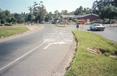
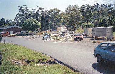
 Eltham District Historical Society Inc
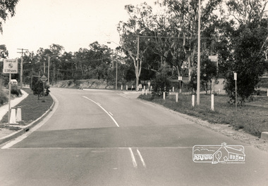
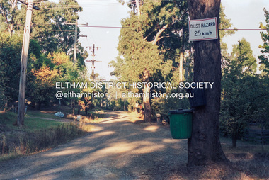
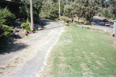
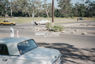
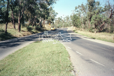
Negative - Photograph, Intersection of Mt Pleasant Road at Main Road, Eltham, c.Dec. 1983
... ...road sign...Instead traffic islands on Mount Pleasant Road were installed in place of temporary blocked out islands and revised extended driveway to properties 622-642 Main Road with access off Mount Pleasant Road instead. infrastructure roads road construction roundabout road sign main road mount pleasant road eltham Film - Kodak CM 400 5079 7 strips, 26 frames Intersection of Mt Pleasant Road at Main Road, Eltham Negative Photograph ...Reconstruction work was planned for Main Road to install a roundabout at Mount Pleasant Road. Traffic to Lower Plenty and Templestowe to be diverted down Bridge Street (and Bolton Street) effective January 1984. The proposed roundabout did not proceed. Instead traffic islands on Mount Pleasant Road were installed in place of temporary blocked out islands and revised extended driveway to properties 622-642 Main Road with access off Mount Pleasant Road instead.Film - Kodak CM 400 5079 7 strips, 26 framesinfrastructure, roads, road construction, roundabout, road sign, main road, mount pleasant road, eltham -
 Eltham District Historical Society Inc
Negative - Photograph, Intersection of Mt Pleasant Road at Main Road, Eltham, c.Dec. 1983
... ...road sign...Instead traffic islands on Mount Pleasant Road were installed in place of temporary blocked out islands and revised extended driveway to properties 622-642 Main Road with access off Mount Pleasant Road instead. infrastructure roads road construction roundabout road sign main road mount pleasant road eltham Service Station Film - Kodak CM 400 5079 7 strips, 26 frames Intersection of Mt Pleasant Road at Main Road, Eltham Negative Photograph ...Reconstruction work was planned for Main Road to install a roundabout at Mount Pleasant Road. Traffic to Lower Plenty and Templestowe to be diverted down Bridge Street (and Bolton Street) effective January 1984. The proposed roundabout did not proceed. Instead traffic islands on Mount Pleasant Road were installed in place of temporary blocked out islands and revised extended driveway to properties 622-642 Main Road with access off Mount Pleasant Road instead.Film - Kodak CM 400 5079 7 strips, 26 framesinfrastructure, roads, road construction, roundabout, road sign, main road, mount pleasant road, eltham, service station -
 Eltham District Historical Society Inc
Negative - Photograph, Intersection of Mt Pleasant Road at Main Road, Eltham, c.Dec. 1983
... ...road sign...Instead traffic islands on Mount Pleasant Road were installed in place of temporary blocked out islands and revised extended driveway to properties 622-642 Main Road with access off Mount Pleasant Road instead. infrastructure roads road construction roundabout road sign main road mount pleasant road eltham Film - Kodak CM 400 5079 7 strips, 26 frames Intersection of Mt Pleasant Road at Main Road, Eltham Negative Photograph ...Reconstruction work was planned for Main Road to install a roundabout at Mount Pleasant Road. Traffic to Lower Plenty and Templestowe to be diverted down Bridge Street (and Bolton Street) effective January 1984. The proposed roundabout did not proceed. Instead traffic islands on Mount Pleasant Road were installed in place of temporary blocked out islands and revised extended driveway to properties 622-642 Main Road with access off Mount Pleasant Road instead.Film - Kodak CM 400 5079 7 strips, 26 framesinfrastructure, roads, road construction, roundabout, road sign, main road, mount pleasant road, eltham -
 Eltham District Historical Society Inc
Negative - Photograph, Intersection of Mt Pleasant Road at Main Road, Eltham, c.Dec. 1983
... ...road sign...Instead traffic islands on Mount Pleasant Road were installed in place of temporary blocked out islands and revised extended driveway to properties 622-642 Main Road with access off Mount Pleasant Road instead. infrastructure roads road construction roundabout road sign main road mount pleasant road eltham Film - Kodak CM 400 5079 7 strips, 26 frames Intersection of Mt Pleasant Road at Main Road, Eltham Negative Photograph ...Reconstruction work was planned for Main Road to install a roundabout at Mount Pleasant Road. Traffic to Lower Plenty and Templestowe to be diverted down Bridge Street (and Bolton Street) effective January 1984. The proposed roundabout did not proceed. Instead traffic islands on Mount Pleasant Road were installed in place of temporary blocked out islands and revised extended driveway to properties 622-642 Main Road with access off Mount Pleasant Road instead.Film - Kodak CM 400 5079 7 strips, 26 framesinfrastructure, roads, road construction, roundabout, road sign, main road, mount pleasant road, eltham