Showing 13 items matching "roads road diversions"
-
 University of Melbourne, Burnley Campus Archives
Plan, Road Diversions, 19--?
... ...roads road diversions...University of Melbourne, Burnley Campus Archives 500 Yarra Boulevard Richmond melbourne burnley college roads road diversions roads Sketch plan of Burnley College grounds showing road diversions between 1881 and 1889. ...Sketch plan of Burnley College grounds showing road diversions between 1881 and 1889.burnley college, roads road diversions, roads -
 Orbost & District Historical Society
black and white photograph, first half 20th century
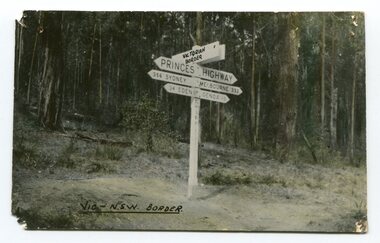
... road surface was anything but good, even by C1917 when cars started to use the road. From Orbost the old road via Marlo to Sydenham was abandoned for the new location which traversed more rugged country via Cabbage Tree, Bell Bird and Club Terrace to Cann River, and the reason for this diversion was on account of settlements being established at Murrungowar and Club Terrace, at which latter place there was a temporary rush to obtain gold. ...road surface was anything but good, even by C1917 when cars started to use the road. From Orbost the old road via Marlo to Sydenham was abandoned for the new location which traversed more rugged country via Cabbage Tree, Bell Bird and Club Terrace to Cann River, and the reason for this diversion was on account of settlements being established at Murrungowar and Club Terrace, at which latter place there was a temporary rush to obtain gold. ...Prior to the sealing of the Princes Highway west of Orbost, the road surface was anything but good, even by C1917 when cars started to use the road. From Orbost the old road via Marlo to Sydenham was abandoned for the new location which traversed more rugged country via Cabbage Tree, Bell Bird and Club Terrace to Cann River, and the reason for this diversion was on account of settlements being established at Murrungowar and Club Terrace, at which latter place there was a temporary rush to obtain gold. This road was constructed by the Public Works department and a maximum grade of 1 in 19 was adopted, and as speed was not to be catered for the grade followed in and out round the spurs and gullies, resulting in a maze of turns and twists which required a good deal of skill on the part of the horse driver to negotiate." - Bairnsdale Advertiser, Friday, May 2, 1947. (More information from Newsletter February 2010)This is a pictorial record of an early road distance sign on a major highway through East Gippsland. The distances are indicated in miles, a measurement standard no longer in use.A black / white photograph postcard of the signpost at the Victorian - New South Wales border. It shows distances to Sydney and Eden on one arrow and distances to Melbourne and Genoa on another. on front - Vic - NSW Borderprinces-highway-east-gippsland road-transport road-sign -
 Orbost & District Historical Society
black and white photograph, late 19th century - early 20th century
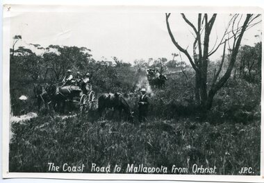
... road surface was anything but good, even by C1917 when cars started to use the road. From Orbost the old road via Marlo to Sydenham was abandoned for the new location which traversed more rugged country via Cabbage Tree, Bell Bird and Club Terrace to Cann River, and the reason for this diversion was on account of settlements being established at Murrungowar and Club Terrace, at which latter place there was a temporary rush to obtain gold. ...road surface was anything but good, even by C1917 when cars started to use the road. From Orbost the old road via Marlo to Sydenham was abandoned for the new location which traversed more rugged country via Cabbage Tree, Bell Bird and Club Terrace to Cann River, and the reason for this diversion was on account of settlements being established at Murrungowar and Club Terrace, at which latter place there was a temporary rush to obtain gold. ...Prior to the sealing of the Princes Highway west of Orbost, the road surface was anything but good, even by C1917 when cars started to use the road. From Orbost the old road via Marlo to Sydenham was abandoned for the new location which traversed more rugged country via Cabbage Tree, Bell Bird and Club Terrace to Cann River, and the reason for this diversion was on account of settlements being established at Murrungowar and Club Terrace, at which latter place there was a temporary rush to obtain gold. This road was constructed by the Public Works department and a maximum grade of 1 in 19 was adopted, and as speed was not to be catered for the grade followed in and out round the spurs and gullies, resulting in a maze of turns and twists which required a good deal of skill on the part of the horse driver to negotiate." - Bairnsdale Advertiser, Friday, May 2, 1947. (More information from Newsletter February 2010)n the late 1800's early 1900's transporting goods by road was difficult and at times impossible because roads as thoroughfares did not exist.The means of travelling along the roads in the 1800's was by bullock wagon, horse pulled dray, pack horse or simply by foot. This road is still in use in East Gippsland as a part of many four-wheel-drive touring routes.A large black / white photograph of two horse - drawn wagons on a narrow sandy bush track. It is surrounded by scrub. There is one man standing beside a horse not harnessed to a wagon.on front - "The Coast Road to Mallacoota from Orbost JPC" -
 Orbost & District Historical Society
black and white photograph, 1918
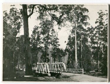
... road surface was anything but good, even by C1917 when cars started to use the road. From Orbost the old road via Marlo to Sydenham was abandoned for the new location which traversed more rugged country via Cabbage Tree, Bell Bird and Club Terrace to Cann River, and the reason for this diversion was on account of settlements being established at Murrungowar and Club Terrace, at which latter place there was a temporary rush to obtain gold. ...road surface was anything but good, even by C1917 when cars started to use the road. From Orbost the old road via Marlo to Sydenham was abandoned for the new location which traversed more rugged country via Cabbage Tree, Bell Bird and Club Terrace to Cann River, and the reason for this diversion was on account of settlements being established at Murrungowar and Club Terrace, at which latter place there was a temporary rush to obtain gold. ...Tonghi Creek is 66km north - west of Orbost. Prior to the sealing of the Princes Highway west of Orbost, the road surface was anything but good, even by C1917 when cars started to use the road. From Orbost the old road via Marlo to Sydenham was abandoned for the new location which traversed more rugged country via Cabbage Tree, Bell Bird and Club Terrace to Cann River, and the reason for this diversion was on account of settlements being established at Murrungowar and Club Terrace, at which latter place there was a temporary rush to obtain gold. This road was constructed by the Public Works department and a maximum grade of 1 in 19 was adopted, and as speed was not to be catered for the grade followed in and out round the spurs and gullies, resulting in a maze of turns and twists which required a good deal of skill on the part of the horse driver to negotiate." - Bairnsdale Advertiser, Friday, May 2, 1947. (More information from Newsletter February 2010)This item is a pictorial record of roads in the early 20th century in East Gippsland.A large black / white photograph of a bridge over a small creek, surrounded by bush. The photograph is mounted on a thick cream coloured card.on back - "Bridge at Tonghi Creek 1918"tonghi-creek-bridge country-roads-east-gippsland -
 Melbourne Tram Museum
Photograph - Black and White - Newspaper photo, MMTB SW6 Tram in Flinders Lane for first time, 21 Dec 1944
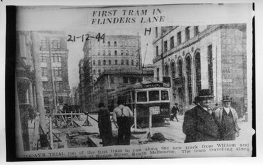
... Melbourne Tram Museum 8 Wallen Road Hawthorn melbourne Image shows a newspaper photo of MMTB SW6 Tram 890 in Flinders Lane operating on the official opening run on new diversion line in William Street, from Collins Street to Hanna Street (now Kings Way) to the corner of Sturt Street on 21 Dec 1944 The Hanna St line provided an additional line into the City from Domain Junction and was designed to relieve pressure on St Kilda Road. ...Image shows a newspaper photo of MMTB SW6 Tram 890 in Flinders Lane operating on the official opening run on new diversion line in William Street, from Collins Street to Hanna Street (now Kings Way) to the corner of Sturt Street on 21 Dec 1944The Hanna St line provided an additional line into the City from Domain Junction and was designed to relieve pressure on St Kilda Road. Black and white print of MMTB SW6 Tram in Flinders Lane for first time tramways, trams, flinders lane, new william street line, opening, tram 890, sw6 class -
 Melbourne Tram Museum
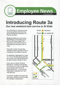
Document - Employee News, Yarra Trams, "Introducing Route 3a", 30/1/2009
... Notice to Yarra Trams employees about the introduction of Route 3a, diversion of route 3 to operate via the St Kilda Esplanade and Fitzroy St. on weekends, rather than operate via St Kilda Road. This route alteration was changed back to operate only via St Kilda Road following the timetable change of 30/10/2023....Melbourne Tram Museum 8 Wallen Road Hawthorn melbourne Notice to Yarra Trams employees about the introduction of Route 3a, diversion of route 3 to operate via the St Kilda Esplanade and Fitzroy St. on weekends, rather than operate via St Kilda Road. This route alteration was changed back to operate only via St Kilda Road ...Notice to Yarra Trams employees about the introduction of Route 3a, diversion of route 3 to operate via the St Kilda Esplanade and Fitzroy St. on weekends, rather than operate via St Kilda Road. This route alteration was changed back to operate only via St Kilda Road following the timetable change of 30/10/2023.Yields information about the operation of route 3aA4 colour sheet dated 30 Jan. 2009tramways, operations, newsletter, route 3a, timetables -
 Melbourne Tram Museum
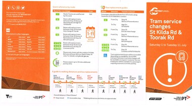
Pamphlet, Public Transport Victoria (PTV), "Tram service changes St Kilda Rd & Toorak Rd", Jun. 2017
... Road West into St Kilda road the closure of the route via Park and Domain Road. Has a map, list of service changes, bus replacement guides and contact information. Has the logos of Metro Tunnel, Yarra Trams and PTV. .2 Pamphlet, printed and cut for use in trams around passenger hanging rails, titled "St Kilda Rd Tram and Bus service changes - Saturday 1 to Tuesday 11 July" - details bus replacement services and tram stops. Related to the main pamphlet - see image Set of five digital images taken at stop 25, Park St advising of the route diversion...Road West into St Kilda road the closure of the route via Park and Domain Road. Has a map, list of service changes, bus replacement guides and contact information. Has the logos of Metro Tunnel, Yarra Trams and PTV. .2 Pamphlet, printed and cut for use in trams around passenger hanging rails, titled "St Kilda Rd Tram and Bus service changes - Saturday 1 to Tuesday 11 July" - details bus replacement services and tram stops. Related to the main pamphlet - see image Set of five digital images taken at stop 25, Park St advising of the route diversion ....1 - Pamphlet - four fold - DL side four colour printed on off-white paper, titled "Tram service changes St Kilda Rd & Toorak Rd", advising intending passengers of the work between 1/7/2017 and 11/7/2017 to connect route 8 at Toorak Road West into St Kilda road the closure of the route via Park and Domain Road. Has a map, list of service changes, bus replacement guides and contact information. Has the logos of Metro Tunnel, Yarra Trams and PTV. .2 Pamphlet, printed and cut for use in trams around passenger hanging rails, titled "St Kilda Rd Tram and Bus service changes - Saturday 1 to Tuesday 11 July" - details bus replacement services and tram stops. Related to the main pamphlet - see image Set of five digital images taken at stop 25, Park St advising of the route diversion, replacement services and stop closure and two protest posters on fences nearby the stop about the Metro Tunnel project trucks using the local streets and the closure of the Park St / Domain Road tram line. .2 Pamphlet, printed and cut for use in trams around passenger hanging rails, titled "St Kilda Rd Tram and Bus service changes - Saturday 1 to Tuesday 11 July" - details bus replacement services and tram stops. Related to the main pamphlet.trams, tramways, park st, domain junction, metro tunnel, toorak rd, st kilda rd, tramway construction -
 Melbourne Tram Museum
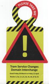
Pamphlet, Public Transport Victoria (PTV), "Tram service changes - Domain Interchange", 2013
... Pamphlet or hanging notice to around tram handrails, cut out advised of the changes to services due to tramway or other works. .1 - Multiple routes - Domain Interchange 29 March 2013 to 12 April 2013 for the redevelopment of the interchange, St Kilda Road and Domain Road and Park St. Gives details of the diversions....Melbourne Tram Museum 8 Wallen Road Hawthorn melbourne Trams tramways Trackwork Domain Interchange Domain Junction Domain Rd Park St St Kilda Rd Bus Replacement Notices And Information tram 3521 Pamphlet or hanging notice to around tram handrails, cut out advised of the changes to services due to tramway or other works. .1 - Multiple routes - Domain Interchange 29 March 2013 to 12 April 2013 for the redevelopment of the interchange, St Kilda Road and Domain Road and Park St. Gives details of the diversions ...Pamphlet or hanging notice to around tram handrails, cut out advised of the changes to services due to tramway or other works. .1 - Multiple routes - Domain Interchange 29 March 2013 to 12 April 2013 for the redevelopment of the interchange, St Kilda Road and Domain Road and Park St. Gives details of the diversions.trams, tramways, trackwork, domain interchange, domain junction, domain rd, park st, st kilda rd, bus replacement, notices and information, tram 3521 -
 City of Kingston
Photograph - Black and white
... Road, Parkdale Parkdale This photograph depicts the road diversion on Nepean Highway that was implemented to allow construction of the railway line underneath the Nepean Highway at Moorabbin. An "Allourie" Cheese, Honey Canned Ham van is prominent on the left of the image, the railway gates are central and the old Moorabbin Station is visble. Beyond the dates, pedestrians are visible crossing the Nepean Highway. This image is part of a larger collection of images from the Public Transport Corporation displaying train stations and streetscapes in what is now the City of Kingston. In 1958 excavations began for the removal of the level crossing gates at the southern end of the Moorabbin shopping centre on Nepean Highway. The station was also lowered below ground. A diversion route was created to enable the flow of traffic in both directions along the highway. Railway crossing Railway station City of Moorabbin White adhesive dot sticker: Printed black 199 Handwritten in red ink: 80% Handwritten in black ink on yellow Post-It Note: [indecipherable] 199 - Diversion for Crossing Stamped in blue ink: COPYRIGHT Public Transport Corporation, For reordering photographs, Please quote negative No m 5687, Enquiries C/- PTC Photographic Unit, Telephone switchboard 619 1111 Black and white photograph of road ...This photograph depicts the road diversion on Nepean Highway that was implemented to allow construction of the railway line underneath the Nepean Highway at Moorabbin. An "Allourie" Cheese, Honey Canned Ham van is prominent on the left of the image, the railway gates are central and the old Moorabbin Station is visble. Beyond the dates, pedestrians are visible crossing the Nepean Highway. This image is part of a larger collection of images from the Public Transport Corporation displaying train stations and streetscapes in what is now the City of Kingston.In 1958 excavations began for the removal of the level crossing gates at the southern end of the Moorabbin shopping centre on Nepean Highway. The station was also lowered below ground. A diversion route was created to enable the flow of traffic in both directions along the highway.Black and white photograph of road diversion on Nepean Highway, Moorabbin to allow the construction of the railway line below the Nepean Highway at Moorabbin and also to trench the station. This image is part of a larger collection of images from the Public Transport Corporation displaying train stations and streetscapes in what is now the City of Kingston.White adhesive dot sticker: Printed black 199 Handwritten in red ink: 80% Handwritten in black ink on yellow Post-It Note: [indecipherable] 199 - Diversion for Crossing Stamped in blue ink: COPYRIGHT Public Transport Corporation, For reordering photographs, Please quote negative No m 5687, Enquiries C/- PTC Photographic Unit, Telephone switchboard 619 1111railway crossing, railway station, city of moorabbin -
 Melbourne Tram Museum
Slide - Set of 2, Keith Kings, 10/12/1967 12:00:00 AM
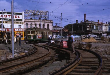
... Melbourne Tram Museum 8 Wallen Road Hawthorn melbourne Trams tramways St Kilda Junction Trackwork Road Works W2 class W5 class Route 64 East Brighton tram 600 tram 521 tram 812 Keith Kings stamp and number "14-23" and "14-28"", with details of exposure. .1 - "MMTB St Kilda Jtn bypass works. W2 600 as the test tram after the St Kilda Junction by Pass, No. 1 diversion trying out the south bound temporary track 3.03pm, Sunday 10/12/67. The North bound track tried out at approx. 12.40pm: .2 - "MMTB 521 (route 64 - City) and 812 (route 64 - East Brighton and Malvern Burke Road ...Set of two 35mm Kodak white cardboard colour slide by Keith Kings of: .1 - W2 600 testing the diverted track at St Kilda Jtn. Sunday 10/12/1967. Looking south See Keith's notes as well. Track welding being carried out. Tram showing Special. In the background are signs for Castrol, Speedie Electrical Appliances. .2 - W5 812 and W2 521 on the temporary track following the first diversion for the construction of the new bridge works looking north. Also see Keith's notes. 812 has adverts for wax and Harold's diamonds.Keith Kings stamp and number "14-23" and "14-28"", with details of exposure. .1 - "MMTB St Kilda Jtn bypass works. W2 600 as the test tram after the St Kilda Junction by Pass, No. 1 diversion trying out the south bound temporary track 3.03pm, Sunday 10/12/67. The North bound track tried out at approx. 12.40pm: .2 - "MMTB 521 (route 64 - City) and 812 (route 64 - East Brighton and Malvern Burke Road) on temporary track at St Kilda Jtn bypass. Note sharpness of curves and very limited transitions and tangents. Looking north. 10/12/1967trams, tramways, st kilda junction, trackwork, road works, w2 class, w5 class, route 64, east brighton, tram 600, tram 521, tram 812 -
 Melbourne Tram Museum
Slide - Set of 2, Keith Kings, 24/12/1967 12:00:00 AM
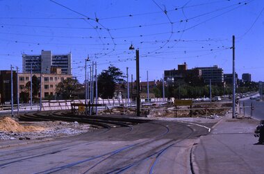
... Set of two 35mm Kodak white cardboard colour slide by Keith Kings of 24/12/1967 - .1 - St Kilda Junction, looking north along St Kilda Road, showing the nature of the diversion from the junction for Wellington St. .2 - Dandenong Road, showing the track diversion work for Dandenong Road/Queensway, Windsor....Melbourne Tram Museum 8 Wallen Road Hawthorn melbourne Trams tramways St Kilda Junction Trackwork Road Works Dandenong Road Queensway tram 907 Keith Kings stamp and number "15-1" and "15-5"", with details of exposure. .1 - SW6 car on temporary track at St Kilda Junction looking north from turnout during freeway work .2 - Dandenong Road west from Hornsby St with section of straight track ready to replace curves onto new b.v.w. track to Chapel St - 907 coming off soon to be abandoned street track. Set of two 35mm Kodak white cardboard colour slide by Keith Kings of 24/12/1967 - .1 - St Kilda Junction, looking north along St Kilda Road, showing the nature of the diversion ...Set of two 35mm Kodak white cardboard colour slide by Keith Kings of 24/12/1967 - .1 - St Kilda Junction, looking north along St Kilda Road, showing the nature of the diversion from the junction for Wellington St. .2 - Dandenong Road, showing the track diversion work for Dandenong Road/Queensway, Windsor.Keith Kings stamp and number "15-1" and "15-5"", with details of exposure. .1 - SW6 car on temporary track at St Kilda Junction looking north from turnout during freeway work .2 - Dandenong Road west from Hornsby St with section of straight track ready to replace curves onto new b.v.w. track to Chapel St - 907 coming off soon to be abandoned street track.trams, tramways, st kilda junction, trackwork, road works, dandenong road, queensway, tram 907 -
 Melbourne Tram Museum
Negative - SW6 901 St Kilda Junction works, Hugh Ballment, early 1968
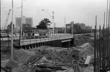
... Melbourne Tram Museum 8 Wallen Road Hawthorn melbourne The photograph shows SW6 class tram 901, (City route 64) northbound on the temporary track section that formed the diversion while the construction of the Queensway underpass was being undertaken. See item 8946 for a photo a tram using the underpass and onto Queens Road ...The photograph shows SW6 class tram 901, (City route 64) northbound on the temporary track section that formed the diversion while the construction of the Queensway underpass was being undertaken. See item 8946 for a photo a tram using the underpass and onto Queens Road, Oct.1968 and item 8962 for a photo during the temporary works stage.Yields information about the tram track arrangements during the construction of St Kilda Junction. Negative - 127 film black and white.tramways, st kilda junction, track work, track construction, sw6 class, tram 901 -
 Melbourne Tram Museum
Photograph - Trams 10W and B2 2031 at Batman Ave, Norm Cross, late 1990s
... Melbourne Tram Museum 8 Wallen Road Hawthorn melbourne Photo shows scrubber tram 10W and B2 class 2031 at the Batman Ave terminus at the intersection with Swanston St/St Kilda Road, prior to the diversion of Batman Ave trams to operate along Flinders St during mid 1999. ...Photo shows scrubber tram 10W and B2 class 2031 at the Batman Ave terminus at the intersection with Swanston St/St Kilda Road, prior to the diversion of Batman Ave trams to operate along Flinders St during mid 1999.Yields information about the Batman Ave terminus and trams 10W and 2031.Colour print on Kodak papertramways, tramcars, tram 10w, tram 2031, batman ave, b class