
Showing 11 items matching "rock lining"
-
 Eltham District Historical Society Inc
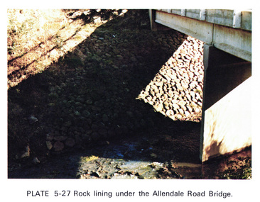
Work on paper (Sub-Item) - Photograph, Rock lining under the Allendale Road Bridge, 1976
... Rock lining under the Allendale Road Bridge...rock lining...Colour photograph of rock lining along the Diamond creek under the Allendale Road Bridge, Eltham North...Colour photograph of rock lining along the Diamond creek under the Allendale Road Bridge, Eltham North rock lining bridge Eltham North Diamond Creek Image printed on A4 page from 04997 Diamond Creek Basin Study, 1980 Rock lining under the Allendale Road Bridge Work on paper Photograph ...Colour photograph of rock lining along the Diamond creek under the Allendale Road Bridge, Eltham Northrock lining, bridge, eltham north, diamond creek -
 Eltham District Historical Society Inc
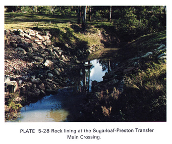
Work on paper (Sub-Item) - Photograph, Rock lining at the Sugarloaf-Preston transfer main crossing, 1976
... Rock lining at the Sugarloaf-Preston transfer main crossing...rock lining...Colour photograph of rock lining at the Sugarloaf-Preston transfer main crossing. ...Colour photograph of rock lining at the Sugarloaf-Preston transfer main crossing. ...Colour photograph of rock lining at the Sugarloaf-Preston transfer main crossing. The Sugarloaf Reservoir and the Winneke Water Treatment Plant (Winneke) are located 32 km north-east of Melbourne, near Christmas Hills. rock lining, water supply -
 Ringwood and District Historical Society
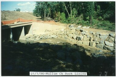
photograph, Eastlink Ringwood Bypass Construction-Mullum Ck Rock Lining 21/1/96
... Eastlink Ringwood Bypass Construction-Mullum Ck Rock Lining 21/1/96...Written on back of photo: "Mullum Ck Rock lining 21/1/96"...Written on back of photo: "Mullum Ck Rock lining 21/1/96" Colour photograph Eastlink Ringwood Bypass Construction-Mullum Ck Rock Lining 21/1/96 photograph ...Colour photographWritten on back of photo: "Mullum Ck Rock lining 21/1/96" -
 Ringwood and District Historical Society
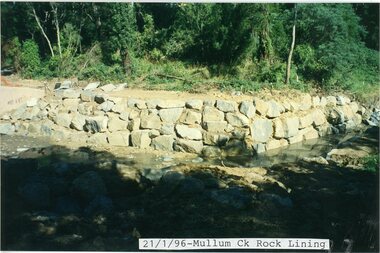
photograph, Eastlink Ringwood Bypass Construction-Mullum Ck Rock Lining 21/1/96
... Eastlink Ringwood Bypass Construction-Mullum Ck Rock Lining 21/1/96...Written on back of photo: "Mullum Ck Rock lining 21/1/96"...Written on back of photo: "Mullum Ck Rock lining 21/1/96" Colour photograph Eastlink Ringwood Bypass Construction-Mullum Ck Rock Lining 21/1/96 photograph ...Colour photographWritten on back of photo: "Mullum Ck Rock lining 21/1/96" -
 Eltham District Historical Society Inc
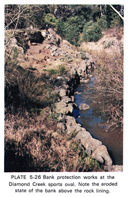
Work on paper (Sub-Item) - Photograph, Bank protection works at the Diamond Creek sports oval
... Note the eroded state of the bank above the rock lining...Note the eroded state of the bank above the rock lining eltham diamond creek erosion protection stone Diamond Creek Sports Oval Image printed on A4 page from 04997 Diamond Creek Basin Study, 1980 Bank protection works at the Diamond Creek sports oval Work on paper Photograph ...Colour photograph of bank protection works, using large stones at the Diamond Creek Sports oval. Note the eroded state of the bank above the rock liningeltham, diamond creek, erosion, protection, stone, diamond creek sports oval -
 Ringwood and District Historical Society
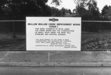
Photograph, Mullum Creek Improvement Works. c1980's
... Sign on wire fence: "Mullum Mullum Creek Improvement Works Stage 1", "This work consists of rock lining the creek banks and the construction of small rock weirs. ...Sign on wire fence: "Mullum Mullum Creek Improvement Works Stage 1", "This work consists of rock lining the creek banks and the construction of small rock weirs. ...Black and white photograph (4 images- V0169, V0170, V0171, V0173)Sign on wire fence: "Mullum Mullum Creek Improvement Works Stage 1", "This work consists of rock lining the creek banks and the construction of small rock weirs. The work will stabilize and control erosion". Estimated Cost $250,000. -
 Flagstaff Hill Maritime Museum and Village
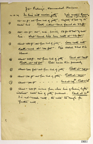
Document - Report, Jet Probings, Warrnambool Harbour, 16-10-1929
... The report mentions lining up with the wooden jetty, the end of the breakwater and the leading lights. It mentions sand, loose rock and rock. ...The report mentions lining up with the wooden jetty, the end of the breakwater and the leading lights. It mentions sand, loose rock and rock. ...This report lists the depths of water and the consistency of the seabed surrounding the Warrnambool Harbour in October 1929, The information, often referred to as 'soundings', was obtained by Jet Probing,. In earlier days a lead line was used to perform a similar task. The author of the document is unknown. Jet Probing is a method used for underwater archaeology, cable installation and coastal engineering. A jet probe is a machine that produces a strong jet of water that penetrates the layers of sediment on the seabed, determining their depth, thickness and consistency. It provides a survey of the seabed and can be used as an aid to engineering design and construction. The report mentions lining up with the wooden jetty, the end of the breakwater and the leading lights. It mentions sand, loose rock and rock. It tells of stopping work due to the water being too rough, the pipe choking, difficulty in connecting pipes, and pipe joint breaking as it tried to get through the sand, The report in the document is significant for its connection with the Warrnambool Harbour, Warrnambool Breakwater, Warrnambool Jetty and Lady Bay. The report gives figures for the depth and consistency of the water and seabed at a particular point in time and can be used to compart with similar figures taken at different times. The results could determine plans for future engineering works.Report, titled 'Jet Probings, Warrnambool Harbour'. Two pages of cream coloured paper with hand written notes in pen and ink. Report covers three days of Jet Probings, with resulting figures and comments, for the depths of the surroundings of the Warrnambool Harbour. The report is in point form, with some underlining. Dates of recordings are 14-10-29, 15-10-29 and 16-10-29. (1929) The situation of the harbour had become a real problem by 1910 and required continuous dredging. In 1914 the Breakwater was extended but proved to be a failure because the work began to subside and by 1920 about two thirds of the harbour was silted up. Alterations made in the 1920's increased the silting problem. The soundings and Jet Probings were done after the Royal Commission of 1923, when the damaged stonework on the seaward side of the Warrnambool Breakwater, caused by the action of the sea, was the subject of enquiry. A conference between the Public Works, Water Commission and the Harbour Trust concluded that it would less costly to make repairs to prevent further damage rather than replaced the damage portion of the wall. A contract was raised in late 1924 to deposit rubble on the damaged side of the breakwater to minimise the Southern Ocean’s destructive action and work had started by August 1925. By the 1940's the harbour was no longer used. More alterations were made in the 1950's and 1960's. document, depth, warrnambool harbour, 1929, soundings, jet probe, jet probing, seabed, map of seabed, underwater engineering, warrnambool jetty, warrnambool breakwater, breakwater upgrade, leading lights, chart the harbour, flagstaff hill, warrnambool, flagstaff hill maritime museum & village, maritime museum, maritime village, shipwreck coast, lady bay, port of warrnambool, breakwater, jetty, pier, vhr h2024, royal commission, 1923, public works, water commission, harbour trust, victorian harbours -
 The Beechworth Burke Museum
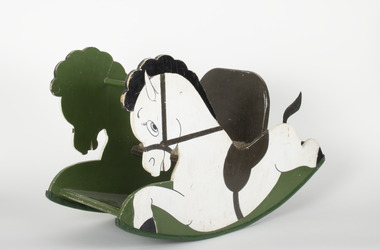
Domestic object - Rocking Horse, c1977
... A small wooden rocking horse painted in green, white and brown, with carpet lining on seat....Beechworth Burke museum Mayday Hills Asylum rocking horse Children's Toys A small wooden rocking horse painted in green, white and brown, with carpet lining on seat. ...Child-size rocking horse made and sold by a patient of Mayday Hills Asylum. Purchased in 1978 and used by a family for generations.Mayday Hills Asylum was one of the three largest psychiatric hospitals in Victoria, and played an important role in the treatment of mental health illnesses from its establishment in 1867 to its closure in 1995. As part of prescribed treatment, many patients participated in craft activities were they were able to create an array of objects. A small wooden rocking horse painted in green, white and brown, with carpet lining on seat.beechworth, burke museum, mayday hills asylum, rocking horse, children's toys -
 Kiewa Valley Historical Society
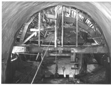
Photograph during construction of West Kiewa tunnel, 'Timbering in West Kiewa Tunnel', c1947
... This historical photograph shows in detail the amount of work necessary to stabilise and support the tunnel walls before lining with concrete. No solid rock was found and the tunneling proceeded through decomposed boulders, gravel and clay, hence the necessity for support and concreting. west kiewa tailrace tunnel Timbering in West Kiewa Tunnel Black and white photograph showing the timber support, prior to lining with concrete, in the West Kiewa tunnel. ...The West Kiewa Tunnel (tailrace tunnel) was commenced from both ends in 1947. Very difficult conditions were encountered in the driving of this tunnel and this meant the immediate provision of support and later the lining of the tunnel with concrete. Work proceeded steadily and the breakthrough of the two headings occurred on 22nd July, 1950.This historical photograph shows in detail the amount of work necessary to stabilise and support the tunnel walls before lining with concrete. No solid rock was found and the tunneling proceeded through decomposed boulders, gravel and clay, hence the necessity for support and concreting. Black and white photograph showing the timber support, prior to lining with concrete, in the West Kiewa tunnel.Timbering in West Kiewa Tunnelwest kiewa, tailrace, tunnel -
 Lakes Entrance Historical Society
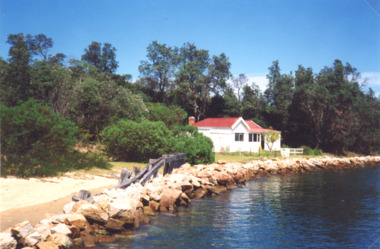
Photograph, Judy Davies, Schnapper Cottage at Lakes Entrance Victoria, March 2001
... Colour photograph of Schnapper Cottage a small white painted dwelling with a red roof situated on the edge of lake edged with rock groynes and the remains of timber railing at western side of entrance at Lakes Entrance Victoria. Also two photographs taken inside Schnapper Cottage showing tongue and groove lining, coved ceiling, dado above wide vertical wall boards...Gippsland Lakes Settlement Houses Colour photograph of Schnapper Cottage a small white painted dwelling with a red roof situated on the edge of lake edged with rock groynes and the remains of timber railing at western side of entrance at Lakes Entrance Victoria. Also two photographs taken inside Schnapper Cottage showing tongue and groove lining, coved ceiling, dado above wide vertical wall boards Schnapper Cottage at Lakes Entrance Victoria Photograph Judy Davies ...Colour photograph of Schnapper Cottage a small white painted dwelling with a red roof situated on the edge of lake edged with rock groynes and the remains of timber railing at western side of entrance at Lakes Entrance Victoria. Also two photographs taken inside Schnapper Cottage showing tongue and groove lining, coved ceiling, dado above wide vertical wall boardsgippsland lakes, settlement, houses -
 The Beechworth Burke Museum
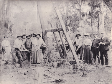
Photograph, c1900
... rock and conventional "hand mining" in soil. TBMs have the advantages of limiting the disturbance to the surrounding ground and producing a smooth tunnel wall. This significantly reduces the cost of lining...rock and conventional "hand mining" in soil. TBMs have the advantages of limiting the disturbance to the surrounding ground and producing a smooth tunnel wall. This significantly reduces the cost of lining ...A black and white photograph depicting seven men and four women surrounded by tunnel boring machinery. A tunnel boring machine (TBM), also known as a "mole", is a machine used to excavate tunnels with a circular cross section through a variety of soil and rock strata. They may also be used for microtunneling. They can be designed to bore through anything from hard rock to sand. Tunnel boring machines are used as an alternative to drilling and blasting (D&B) methods in rock and conventional "hand mining" in soil. TBMs have the advantages of limiting the disturbance to the surrounding ground and producing a smooth tunnel wall. This significantly reduces the cost of lining the tunnel, and makes them suitable to use in heavily urbanised areas. The major disadvantage is the upfront cost. TBMs are expensive to construct, and can be difficult to transport. The longer the tunnel, the less the relative cost of tunnel boring machines versus drill and blast methods. This is because tunneling with TBMs is much more efficient and results in shortened completion times, assuming they operate successfully. Drilling and blasting however remains the preferred method when working through heavily fractured and sheared rock layers.This photograph is significant as it shows the machinery used and attire worn by men and women during the gold rush era. Black and white rectangular photograph printed on photographic paperburke museum, mining, beechworth, boring machinery, excavate, gold, gold fields, gold rush, miners
