Showing 11 items matching "rock view park"
-
 Sunshine and District Historical Society Incorporated
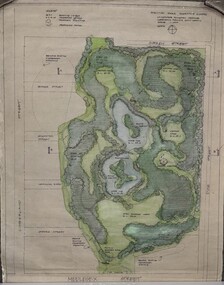
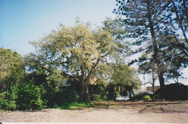
Plan - Proposed "Rock View Park" - Formerly McGraths Quarry Cnr Duke St & Surrey St, Kirby, John
... Proposed "Rock View Park" - Formerly McGraths Quarry Cnr Duke St & Surrey St...Rock View Park...Proposed "Rock View Park" - Formerly McGraths Quarry Cnr Duke St & Surrey St...Rock View Park McGraths Quarry Quarry Duke Street Surrey Street Sunshine North Proposed "Rock View Park" - Formerly McGraths Quarry Cnr Duke St & Surrey St Rolled up paper map showing in color - lake paths and housing lots Plan Proposed "Rock View Park" - Formerly McGraths Quarry Cnr Duke St & Surrey St Kirby, John ...Proposed "Rock View Park" - Formerly McGraths Quarry Cnr Duke St & Surrey Strock view park, mcgraths quarry, quarry, duke street, surrey street, sunshine north -
 Sunshine and District Historical Society Incorporated
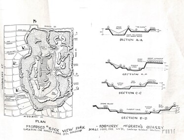
Plan - Proposed "Rock View Park" - Formerly McGraths Quarry Cnr Duke St & Surrey St Plans
... Proposed "Rock View Park" - Formerly McGraths Quarry Cnr Duke St & Surrey St Plans...Proposed "Rock View Park" - Formerly McGraths Quarry Cnr Duke St & Surrey St...McGraths Duke Street Sunshine North Proposed "Rock View Park" - Formerly McGraths Quarry Cnr Duke St & Surrey St Collection of rolled up plans showing proposed lake, streets, paths and housing lots Plan Proposed "Rock View Park" - Formerly McGraths Quarry Cnr Duke St & Surrey St Plans ...Proposed "Rock View Park" - Formerly McGraths Quarry Cnr Duke St & Surrey Stmcgraths, duke street, sunshine north -
 Bendigo Historical Society Inc.
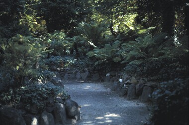
Slide - BENDIGO VIEWS, Apr 1962
... Views. The Fernery, Rosalind Park. Ferns, trees and creepers growing in the fernery. A rock...Views. The Fernery, Rosalind Park. Ferns, trees and creepers growing in the fernery. A rock lined gravel path winds among the ferns. ...Slide. Bendigo Views. The Fernery, Rosalind Park. Ferns, trees and creepers growing in the fernery. A rock lined gravel path winds among the ferns.slide, bendigo, bendigo views, bendigo views -
 Stawell Historical Society Inc
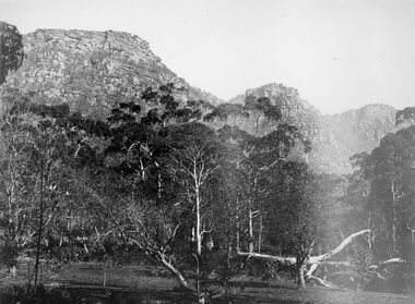
Photograph, Wonderland Range in the Grampians 1866
... Wonderland would probably be the best known part of the whole area, noted for its rugged and weather worn rock formations and spectacular views, too numerous to mention. The Grampians are now a National Park. ...Wonderland would probably be the best known part of the whole area, noted for its rugged and weather worn rock formations and spectacular views, too numerous to mention. The Grampians are now a National Park. ...Grampians (Wonderland Range). Part of a collection of Photographs by Mr. O.G. Armstrong as commissioned by the Shire of Stawell for the Inter-colonial and Paris Exhibition in Melbourne in 1866. The Grampians, with its wildflowers and rock formations, have attracted people from all parts of the world for many years and have always been promoted strongly by local groups. One such group was the Grampians Tourist Association, formed in 1901. Wonderland would probably be the best known part of the whole area, noted for its rugged and weather worn rock formations and spectacular views, too numerous to mention. The Grampians are now a National Park. stawell -
 University of Melbourne, Burnley Campus Archives
Album, Sandra Pullman, National Estate/Heritage Register Photographs, 2001
... rock garden james hitchmough grasslands elm tree dairy red gum kath deery native garden rose garden sequoiadendron giganteum. Photograph Album sent in with the National Estate/Heritage Register by Sandi Pullman. (1) Old car park (Bull Paddock) with Cork Oak. (2) Main Building front steps. (3) Main Building with Magnolia grandiflora. (4)View of Luffmann Ponds and old willow. (5) View of Ginkgo and Emily Gibson bed. (6) Looking between Emily Gibson beds to English Oak. (7) Summer House. (8) Luffmann Ponds. (9) Bergenia Walk with conifers. (10) View of Pencil Pines around entrance to Sunken garden. (11) Luffmann Ponds and Pinus canariensis. (12) View of entrance to Sunken garden. (13-14) Sunken garden. (15) Original terracing at entrance to Shady Walk. (16) Pears in blossom in Field Station. (17) Agathis robusta from the Herb Garden. (18) Ellis Stones Rock garden newly replanted. (19) james Hitchmough Grasslands. (20) Elm tree with Dairy in the background. (21) Original Red Gum in james Hitchmough Grasslands. (22) Kath Deery Native garden. (23-24) Rose Garden. (25) Sequoiadendron giganteum. ...Photograph Album sent in with the National Estate/Heritage Register by Sandi Pullman. (1) Old car park (Bull Paddock) with Cork Oak. (2) Main Building front steps. (3) Main Building with Magnolia grandiflora. (4)View of Luffmann Ponds and old willow. (5) View of Ginkgo and Emily Gibson bed. (6) Looking between Emily Gibson beds to English Oak. (7) Summer House. (8) Luffmann Ponds. (9) Bergenia Walk with conifers. (10) View of Pencil Pines around entrance to Sunken garden. (11) Luffmann Ponds and Pinus canariensis. (12) View of entrance to Sunken garden. (13-14) Sunken garden. (15) Original terracing at entrance to Shady Walk. (16) Pears in blossom in Field Station. (17) Agathis robusta from the Herb Garden. (18) Ellis Stones Rock garden newly replanted. (19) james Hitchmough Grasslands. (20) Elm tree with Dairy in the background. (21) Original Red Gum in james Hitchmough Grasslands. (22) Kath Deery Native garden. (23-24) Rose Garden. (25) Sequoiadendron giganteum.national estate, heritage register, sandi pullman, sandra pullman, bull paddock, cork oak, magnolia, luffmann ponds, willow, ginkgo, emily gibson bed, english oak, summer house, bergenia walk, conifers, pencil pines, sunken garden, pinus canariensis, shady walk, pears, blossoms, field station, agathis robusta, herb garden, ellis stones rock garden, james hitchmough grasslands, elm tree, dairy, red gum, kath deery native garden, rose garden, sequoiadendron giganteum. -
 Ballarat Heritage Services
Photograph - Colour photograph, Tower Hill, 2016, 23/12/2015
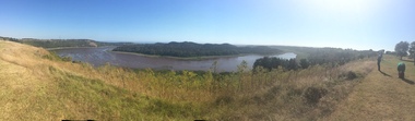
... rock. Violent explosions followed creating a shallow crater which later filled with water to form the lake. Further eruptions occurred in the centre of this crater, creating the islands and cone shaped hills. In 1892 Tower Hill became Victoria’s first National Park. In 1961, Tower Hill became a State Game Reserve under the then Fisheries and Wildlife Department and a major re-vegetation program began. (https://www.towerhill.org.au/index.php/about-reserve/history, accessed 23 December 2019) tower hill volcano crater Panaramic view ...Tower Hill is a volcanic formation believed to have erupted about 32,000 years ago. Its formation is known as a "nested maar" and it is the largest example of its type in Victoria. During formation, molten lava pushed its way up through the Earth’s crust and encountered a layer of water-bearing rock. Violent explosions followed creating a shallow crater which later filled with water to form the lake. Further eruptions occurred in the centre of this crater, creating the islands and cone shaped hills. In 1892 Tower Hill became Victoria’s first National Park. In 1961, Tower Hill became a State Game Reserve under the then Fisheries and Wildlife Department and a major re-vegetation program began. (https://www.towerhill.org.au/index.php/about-reserve/history, accessed 23 December 2019)Panaramic view of Tower Hill, Victoria.tower hill, volcano, crater -
 Ballarat Heritage Services
Photograph - Colour photograph, Tower Hill, 2022, 24/12/2022
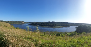
... rock. Violent explosions followed creating a shallow crater which later filled with water to form the lake. Further eruptions occurred in the centre of this crater, creating the islands and cone shaped hills. In 1892 Tower Hill became Victoria’s first National Park. In 1961, Tower Hill became a State Game Reserve under the then Fisheries and Wildlife Department and a major re-vegetation program began. (https://www.towerhill.org.au/index.php/about-reserve/history, accessed 23 December 2019) tower hill volcano crater Panaramic view ...Tower Hill is a volcanic formation believed to have erupted about 32,000 years ago. Its formation is known as a "nested maar" and it is the largest example of its type in Victoria. During formation, molten lava pushed its way up through the Earth’s crust and encountered a layer of water-bearing rock. Violent explosions followed creating a shallow crater which later filled with water to form the lake. Further eruptions occurred in the centre of this crater, creating the islands and cone shaped hills. In 1892 Tower Hill became Victoria’s first National Park. In 1961, Tower Hill became a State Game Reserve under the then Fisheries and Wildlife Department and a major re-vegetation program began. (https://www.towerhill.org.au/index.php/about-reserve/history, accessed 23 December 2019)Panaramic view of Tower Hill, Victoria.tower hill, volcano, crater -
 Kew Historical Society Inc
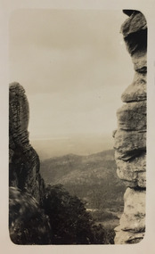
Photograph - Grampians, 1924
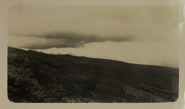
... Park and at Kew. The remainder of the album includes photographs of walking and car tours in rural Victoria including 'wilderness' areas in the Grampians, Gippsland and the High Country. Six album pages document a camping trip by Henry Christian to the Grampians in September 1924. The photos include pictures of lookouts, and natural features including rock faces and waterfalls, as well as his camp site. This photo is a distant view...Park and at Kew. The remainder of the album includes photographs of walking and car tours in rural Victoria including 'wilderness' areas in the Grampians, Gippsland and the High Country. Six album pages document a camping trip by Henry Christian to the Grampians in September 1924. The photos include pictures of lookouts, and natural features including rock faces and waterfalls, as well as his camp site. This photo is a distant view ...Henry Beater Christian (1886-1962) , was a descendant of one of the earliest settler families in Kew. Employed at the Kew Asylum as a 'public servant', he was a skilled amateur photographer, photographing numerous scenes in Kew and on his travels around Victoria. The majority of his photographs date from 1916 to 1929. His finest photographs are housed in two photograph albums. Digital copy of a photograph from page 14 of the 47-page photograph album containing 261 gelatinous silver images, loaned by Diane Washfold with permission given to digitise and hold a copy in our collection. The first and last pages in the album document the Yarra River at Studley Park and at Kew. The remainder of the album includes photographs of walking and car tours in rural Victoria including 'wilderness' areas in the Grampians, Gippsland and the High Country. Six album pages document a camping trip by Henry Christian to the Grampians in September 1924. The photos include pictures of lookouts, and natural features including rock faces and waterfalls, as well as his camp site. This photo is a distant view of the horizon as clouds gather."Grampians"henry beater christian (1886-1962), landscape photography, christian-washfold collection, photograph albums, grampians, gariwerd -
 Kew Historical Society Inc
Photograph - Grampians, 1924
... Park and at Kew. The remainder of the album includes photographs of walking and car tours in rural Victoria including 'wilderness' areas in the Grampians, Gippsland and the High Country. Six album pages document a camping trip by Henry Christian to the Grampians in September 1924. The photos include pictures of lookouts, and natural features including rock faces and waterfalls, as well as his camp site. This photo is a distant view...Park and at Kew. The remainder of the album includes photographs of walking and car tours in rural Victoria including 'wilderness' areas in the Grampians, Gippsland and the High Country. Six album pages document a camping trip by Henry Christian to the Grampians in September 1924. The photos include pictures of lookouts, and natural features including rock faces and waterfalls, as well as his camp site. This photo is a distant view ...Henry Beater Christian (1886-1962) , was a descendant of one of the earliest settler families in Kew. Employed at the Kew Asylum as a 'public servant', he was a skilled amateur photographer, photographing numerous scenes in Kew and on his travels around Victoria. The majority of his photographs date from 1916 to 1929. His finest photographs are housed in two photograph albums. Digital copy of a photograph from page 14 of the 47-page photograph album containing 261 gelatinous silver images, loaned by Diane Washfold with permission given to digitise and hold a copy in our collection. The first and last pages in the album document the Yarra River at Studley Park and at Kew. The remainder of the album includes photographs of walking and car tours in rural Victoria including 'wilderness' areas in the Grampians, Gippsland and the High Country. Six album pages document a camping trip by Henry Christian to the Grampians in September 1924. The photos include pictures of lookouts, and natural features including rock faces and waterfalls, as well as his camp site. This photo is a distant view of the horizon between cliff faces."Grampians"henry beater christian (1886-1962), landscape photography, christian-washfold collection, photograph albums, grampians, gariwerd -
 Kew Historical Society Inc
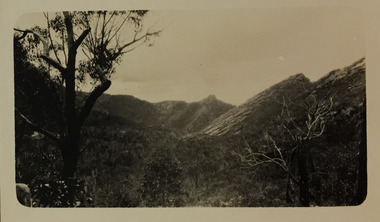
Photograph - Grampians, 1924
... Park and at Kew. The remainder of the album includes photographs of walking and car tours in rural Victoria including 'wilderness' areas in the Grampians, Gippsland and the High Country. Six album pages document a camping trip by Henry Christian to the Grampians in September 1924. The photos include pictures of lookouts, and natural features including rock faces and waterfalls, as well as his camp site. This photo is a long distance view...Park and at Kew. The remainder of the album includes photographs of walking and car tours in rural Victoria including 'wilderness' areas in the Grampians, Gippsland and the High Country. Six album pages document a camping trip by Henry Christian to the Grampians in September 1924. The photos include pictures of lookouts, and natural features including rock faces and waterfalls, as well as his camp site. This photo is a long distance view ...Henry Beater Christian (1886-1962) , was a descendant of one of the earliest settler families in Kew. Employed at the Kew Asylum as a 'public servant', he was a skilled amateur photographer, photographing numerous scenes in Kew and on his travels around Victoria. The majority of his photographs date from 1916 to 1929. His finest photographs are housed in two photograph albums. Digital copy of a photograph from page 15 of the 47-page photograph album containing 261 gelatinous silver images, loaned by Diane Washfold with permission given to digitise and hold a copy in our collection. The first and last pages in the album document the Yarra River at Studley Park and at Kew. The remainder of the album includes photographs of walking and car tours in rural Victoria including 'wilderness' areas in the Grampians, Gippsland and the High Country. Six album pages document a camping trip by Henry Christian to the Grampians in September 1924. The photos include pictures of lookouts, and natural features including rock faces and waterfalls, as well as his camp site. This photo is a long distance view of the mountains with trees framing the picture in the foreground. "Grampians"henry beater christian (1886-1962), landscape photography, christian-washfold collection, photograph albums, grampians, mt victory, gariwerd -
 Melbourne Tram Museum
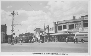
Photograph - VR tram 51 at Black Rock terminus, Murray Views, 1950s
... Rock shopping centre terminus as many passengers in summer clothing alight and board. Both trolley poles are still raised waiting for the conductor to secure the front pole to the car roof. Several motor cars are parked and a small public bus is seen in the foreground. Yields information about Black Rock terminus and VR 51 VR tram tram 51 Black Rock shopping cente summer clothing trolley poles motor cars public bus In ink on the rear "Post Card by Murray Views, Gympie ,Q" Black and white photograph with printer ID on the rear. ...The photograph shows VR tram 51at Black Rock shopping centre terminus as many passengers in summer clothing alight and board. Both trolley poles are still raised waiting for the conductor to secure the front pole to the car roof. Several motor cars are parked and a small public bus is seen in the foreground. Yields information about Black Rock terminus and VR 51Black and white photograph with printer ID on the rear.In ink on the rear "Post Card by Murray Views, Gympie ,Q" vr tram, tram 51, black rock, shopping cente, summer clothing, trolley poles, motor cars, public bus