Showing 256 items matching "ruins"
-
 Linton and District Historical Society Inc
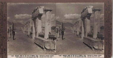
Stereograph, The Rose Stereographs, Melbourne, Sydney, Wellington and London, 14, 651 Majestic Ruins of the City of Pompeii, Italy, Copyright 1912
... 14, 651 Majestic Ruins of the City of Pompeii, Italy...Stereograph of two black and white images showing a man standing in front of the ruins of Pompeii....14,651. MAJESTIC RUINS OF THE CITY OF POMPEII, ITALY. Destroyed by Volcanic Eruption / of Mt. ...Stereographs 14,651. MAJESTIC RUINS OF THE CITY OF POMPEII, ITALY. Destroyed by Volcanic Eruption / of Mt. ...One of two sets of stereographs donated by the O'Beirne family along with a stereoscope for viewing (Stereoscope is Registration no. 2014-51).Stereograph of two black and white images showing a man standing in front of the ruins of Pompeii.14,651. MAJESTIC RUINS OF THE CITY OF POMPEII, ITALY. Destroyed by Volcanic Eruption / of Mt. Vesuvius A.D. 79, and Excavated about 1764.stereographs -
 Lakes Entrance Historical Society
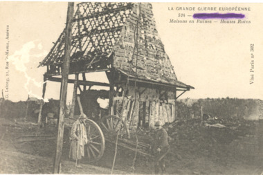
Postcard - Charles Sands WW1 AIF Correspondence, La Grande Guerre House Ruins, c1915
... La Grande Guerre House Ruins...Black and white postcard showing two men beside ruins of house and wagon ...LA GRANDE GUERRE EUROPEENNE 524 Maisons en Ruines - House Ruins Vise Paris no. 302 G.Lelong, 21, Rue St. ...Martin, Amiens Black and white postcard showing two men beside ruins of house and wagon La Grande Guerre House Ruins Postcard Charles Sands WW1 AIF Correspondence ...Postcard sent to Alan Davidson , Buchan South from Charles Sands . Correspondenc on back of card.Black and white postcard showing two men beside ruins of house and wagon LA GRANDE GUERRE EUROPEENNE 524 Maisons en Ruines - House Ruins Vise Paris no. 302 G.Lelong, 21, Rue St. Martin, Amiensww1, correspondence -
 Eltham District Historical Society Inc
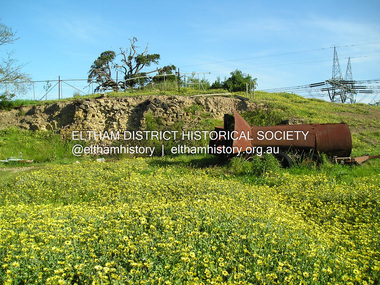
Photograph, Ruins of Coulstocks Mill, Janefield, South Morang
... Ruins of Coulstocks Mill, Janefield, South Morang......ruins...Five colour photographs of ruins of Coulstocks Mill, Janefield (Mill Park - Bundoora)...With water diverted from the Plenty River to fill the newly built Yan Yean Reservoir which opened in 1857, the Hurlestone family quit and that was the demise of the mill. mills flour mills coulstock janefield plenty river ruins stone walls bundoora plenty gorge Five colour photographs of ruins of Coulstocks Mill, Janefield (Mill Park - Bundoora) Ruins of Coulstocks Mill, Janefield, South Morang Photograph Photograph ...Mill Park Farm at Janefield on the Plenty River was established around 1840 by George Coulstock where he grew wheat. His flour mill was one of the first in Victoria, under construction as early as 1841. After bushfires and Coulstock's early death in 1842, the farm and its mill were taken over by local landowners Henry Miller and John Brock. Peter Hurlestone took charge of the mill. With water diverted from the Plenty River to fill the newly built Yan Yean Reservoir which opened in 1857, the Hurlestone family quit and that was the demise of the mill.Five colour photographs of ruins of Coulstocks Mill, Janefield (Mill Park - Bundoora)mills, flour mills, coulstock, janefield, plenty river, ruins, stone walls, bundoora, plenty gorge -
 Tatura Irrigation & Wartime Camps Museum
Photograph, Arthur Knee, Guard tower ruins camp 13, 1989
... Guard tower ruins camp 13......ruins...Camp 13 guard observation tower beams (ruins) in paddock. Timber and wire fence mid distance....Tatura Irrigation & Wartime Camps Museum 49 Hogan Street Tatura the-murray Camp 13 guard observation tower beams (ruins) in paddock. Timber and wire fence mid distance. camp 13 internment camp murchison victoria observation tower ruins Guard tower ruins Camp 13, Camp Road, Murchison, Victoria. ...Camp 13 guard observation tower beams (ruins) in paddock. Timber and wire fence mid distance.Camp 13, Camp Road, Murchison, Victoria. Timber beams, remnants of guard observation tower (foreground).camp 13, internment camp, murchison victoria, observation tower, ruins, guard tower ruins -
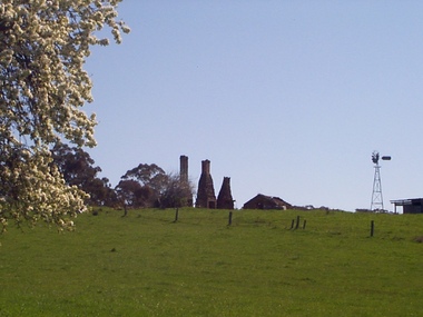
 Ballarat Heritage Services
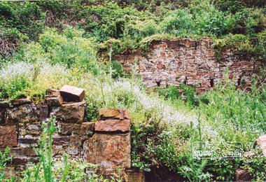
Photograph - Photograph - Colour, Ruins Near Basalt, Victoria
... Ruins Near Basalt, Victoria...Colour photograph of ruins in the landscape near Basalt. ...Ballarat Heritage Services PO Box 2209 Bakery Hill Post Office goldfields basalt ruin chimney Colour photograph of ruins in the landscape near Basalt. Ruins Near Basalt, Victoria Photograph Photograph - Colour ...Colour photograph of ruins in the landscape near Basalt. basalt, ruin, chimney -
 Eltham District Historical Society Inc
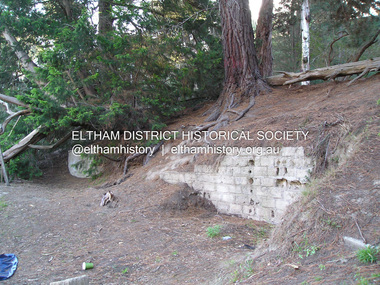
Photograph, Ruins of Coulstocks Mill, Janefield, South Morang
... Ruins of Coulstocks Mill, Janefield, South Morang......ruins...Four colour photographs showing the ruins of Coulstocks Flour Mill (Janefield Mill), Janefield. 1. ...Tree near old mill site Ruins of Coulstocks Mill, Janefield, South Morang Photograph Photograph ...Mill Park Farm at Janefield on the Plenty River was established around 1840 by George Coulstock where he grew wheat. His flour mill was one of the first in Victoria, under construction as early as 1841. After bushfires and Coulstock's early death in 1842, the farm and its mill were taken over by local landowners Henry Miller and John Brock. Peter Hurlestone took charge of the mill. With water diverted from the Plenty River to fill the newly built Yan Yean Reservoir which opened in 1857, the Hurlestone family quit and that was the demise of the mill.Four colour photographs showing the ruins of Coulstocks Flour Mill (Janefield Mill), Janefield. 1. Stone wall 2. Old mill 3. Stone remains of old mill 4. Tree near old mill sitemills, flour mills, coulstock, janefield, plenty river, ruins, stone walls, plenty gorge, bundoora -
 Ballarat Heritage Services
Photograph - Photograph - Colour, Clare Gervasoni, Pedretti Homestead Ruins at Elevated Plains, Victoria, c1990, 22/04/1991
... Pedretti Homestead Ruins at Elevated Plains, Victoria, c1990...Four colour photographs of Martino Pedretti's farm, and the ruins of his drystone house. Mount Franklin (Lalgambook) in the distance....Pedretti Homestead Ruins at Elevated Plains, Victoria, c1990 Photograph Photograph - Colour Clare Gervasoni ...Martino Pedretti was born in Brusio, Switzerland.Four colour photographs of Martino Pedretti's farm, and the ruins of his drystone house. Mount Franklin (Lalgambook) in the distance.martino pedretti, elevated plains, dry diggings, drystone, mount franklin, lalgambook -
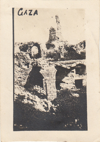 Greensborough Historical Society
Photograph - Digital image, Charles Marshall et al, Ruins in Gaza, 1917_
... Ruins in Gaza...This photograph shows ruins in Gaza....Ruins in Gaza Photograph - Digital image Charles Marshall John Gibson ...This photograph shows ruins in Gaza.Digital copy of black and white photograph. No caption on this photographcharles marshall, world war 1 -
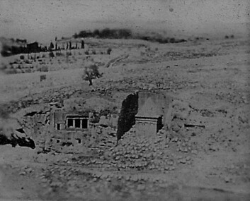 Greensborough Historical Society
Photograph - Digital image, Charles Marshall et al, Ruins along the way, 1917_
... Ruins along the way...This photograph shows ruins (location not known)...Ruins along the way Photograph - Digital image Charles Marshall John Gibson ...This photograph shows ruins (location not known)Digital copy of black and white photograph. No caption on this photographcharles marshall, world war 1 -
 Greensborough Historical Society
Photograph - Digital image, Charles Marshall et al, Ruins of Church, Biroth, 1917_
... Ruins of Church, Biroth...This photograph shows ruins of Church in Biroth....Ruins of Church, Biroth Photograph - Digital image Charles Marshall John Gibson ...This photograph shows ruins of Church in Biroth.Digital copy of black and white photograph. No caption on this photographcharles marshall, world war 1 -
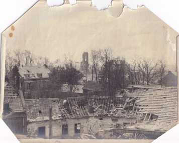
 Whitehorse Historical Society Inc.
Document, Councillors meet in the ruins, 1/09/1927 12:00:00 AM
... Councillors meet in the ruins...Photocopy of newspaper photo showing councillors meeting beside the ruins of the Blackburn and Mitcham municipal chambers, Whitehorse Road, Tunstall after they had been destroyed by fire....Councillors meet in the ruins Document Document ...Photocopy of newspaper photo showing councillors meeting beside the ruins of the Blackburn and Mitcham municipal chambers, Whitehorse Road, Tunstall after they had been destroyed by firePhotocopy of newspaper photo showing councillors meeting beside the ruins of the Blackburn and Mitcham municipal chambers, Whitehorse Road, Tunstall after they had been destroyed by fire.Photocopy of newspaper photo showing councillors meeting beside the ruins of the Blackburn and Mitcham municipal chambers, Whitehorse Road, Tunstall after they had been destroyed by fireshire of blackburn and mitcham, fires, councillors, municipal offices -
 Greensborough Historical Society
Photograph - Digital image, Charles Marshall et al, Ruins below a modern building, 1917_
... Ruins below a modern building...This photograph shows ruins below a modern building (location not known)...Ruins below a modern building Photograph - Digital image Charles Marshall John Gibson ...This photograph shows ruins below a modern building (location not known)Digital copy of black and white photograph. No caption on this photographcharles marshall, world war 1 -
 Stawell Historical Society Inc
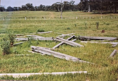
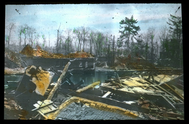
Photograph, “Vinelea” Homesteads burntout ruins after the 1984 fire
... “Vinelea” Homesteads burntout ruins after the 1984 fire....Burnt out ruins of “Vinelea” Homestead after 1984 fire....Stawell Historical Society Inc 46 Longfield St Stawell grampians Burnt out ruins of “Vinelea” Homestead after 1984 fire. ...Burnt out ruins of “Vinelea” Homestead after 1984 fire.Colour Photograph of the remains of a house fire, Four standing chimneys and steel tanks, also a couple of wooden buildings still standingOn Rear: Vinelea House Fire 1984stawell, monaghan, vinelea -
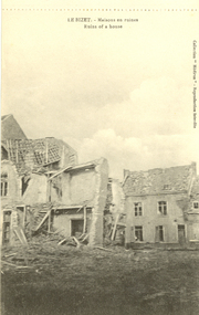 Federation University Historical Collection
Postcard - black and white, Ruins of a house at Le Bizet, c1917
... Ruins of a house at Le Bizet...Black and white postcard showing houses in Le Bizet, Belgium in ruins after bombing during World War One. This card was purchased by an Australian soldier, probably Henry Smerdon Holmes, during World War One. ...Ruins of a house at Le Bizet Postcard - black and white ...Le Bizet is a village in the Belgian province of Hainaut . It lies in the district of Ploegsteert and is near the French border. This postcard was purchased by an Australian soldier during World War One. Black and white postcard showing houses in Le Bizet, Belgium in ruins after bombing during World War One. This card was purchased by an Australian soldier, probably Henry Smerdon Holmes, during World War One. chatham-holmes family collection, le bizet, belgium, ploegsteert, world war, world war 1, bombing, world war one, western front -
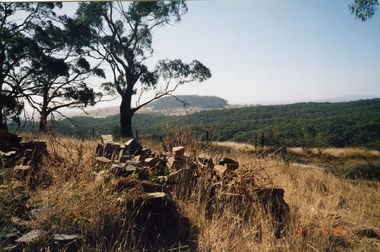
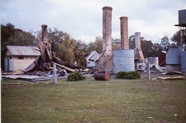
 Ballarat Heritage Services
Photograph - Colour, Ruins at Basalt, Victoria, 28/09/1999
... Ruins at Basalt, Victoria......ruins...Ruins at Basalt, Victoria Photograph - Colour ...Colour photograph of chimneys at Basalt.basalt, ruins, chimneys -
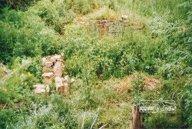
 Eltham District Historical Society Inc
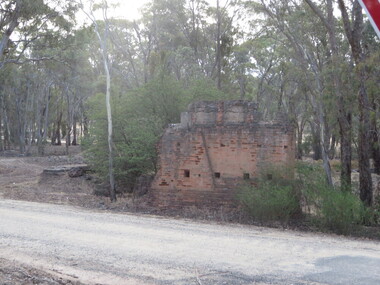
Photograph, Fay Bridge, Ruins beside the Diamond Creek at Wattle Glen, 13 October 2016
... Ruins beside the Diamond Creek at Wattle Glen......Ruins...The newly constructed Diamond Creek Trail from Diamond Creek to Wattle Glen completed in February 2021 winds around these ruins just pass the high transmission power lines near Herberts Lane and Collard Drive From Jean Verso, Nillumbik Historical Society, 15 April 2021 William Wandless Herbert bought the surrounding 100 acres in 1852. ...Heritage Victoria link for the site - https://vhd.heritagecouncil.vic.gov.au/places/12203 Fay Bridge Collection 2016-10-13 Diamond Creek diamond creek trail Ruins Wattle Glen William Wandless Herbert greenhills Elizabeth Wilson 7 images - born digital Ruins beside the Diamond Creek at Wattle Glen Photograph Photograph Fay Bridge ...The newly constructed Diamond Creek Trail from Diamond Creek to Wattle Glen completed in February 2021 winds around these ruins just pass the high transmission power lines near Herberts Lane and Collard Drive From Jean Verso, Nillumbik Historical Society, 15 April 2021 William Wandless Herbert bought the surrounding 100 acres in 1852. He was a native of Northumberland and the Scottish Borders who arrived in Melbourne in 1847. The house on the top of the mound would have been built not long after he bought the land; the farm was named "Greenhills". He married Elizabeth Wilson, daughter of John Wilson who had been in Diamond Creek since about 1846. Their first child was born in 1854 so there would be some form of dwelling from about that time. They had eight children who all survived to a good age. His will describes the house as part stone and part wood and of four rooms. Nillumbik Historical Society (NHS) believe it was one of the earliest if not the earliest house, in this part of the district. The remains of the stone house foundations are on top of the mound (photos on the VHD page) and the barn walls are on the north and to the east side of the mound. NHS is not sure how much or which part of the surrounding area was covered by the barns but they were large enough to hold dances after the race meetings that were held in the late 1880's on the adjacent creek flats. It would make sense with the lay of the land that they covered some of the ground to the north and east and used for farm storage, packing sheds for their apple and pear orchards and also for supporting the Nillumbik Gold Mine the family worked to the north up the gully. The path that comes down the gully and runs into the trail goes past the mine site which was on the west side of the gully a couple of hundred metres up from the flats. Heritage Victoria link for the site - https://vhd.heritagecouncil.vic.gov.au/places/12203fay bridge collection, 2016-10-13, diamond creek, diamond creek trail, ruins, wattle glen, william wandless herbert, greenhills, elizabeth wilson -
 Eltham District Historical Society Inc
Photograph, Fay Bridge, Ruins at Griffith Park, Eltham near the Yarra River, June 2016
... Ruins at Griffith Park, Eltham near the Yarra River......Ruins...Eltham District Historical Society Inc 728 Main Rd Eltham melbourne Griffith Park is the former property and home of Cr Fred Griffith in the 1950s Fay Bridge Collection 2016-06 Griffith Park Ruins 3 images - born digital Ruins at Griffith Park, Eltham near the Yarra River Photograph Photograph Fay Bridge ...Griffith Park is the former property and home of Cr Fred Griffith in the 1950sfay bridge collection, 2016-06, griffith park, ruins -
 Eltham District Historical Society Inc
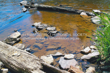
Photograph, Fay Bridge, Ruins of the old Warrandyte Battery, 7 November 2016
... Ruins of the old Warrandyte Battery......Ruins...Fay Bridge Collection 2016-11-07 Warrandyte Battery Ruins 3 images - born digital Ruins of the old Warrandyte Battery Photograph Photograph Fay Bridge ...Remains of the timber foundation of the State Battery, built here in 1897 can be seen on the banks of the Yarra River just east of the Warrandyte Bridge on the Warrandyte side of the river. The Battery was driven by waterwheel and was used to crush ore from the Warrandyte Goldfields.fay bridge collection, 2016-11-07, warrandyte battery, ruins -
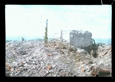
 Ballarat Heritage Services
Photograph - Photograph - Colour, Steele's Pioneer Mine Ruins, Yandoit, 2016, 18/01/2016
... Steele's Pioneer Mine Ruins, Yandoit, 2016......ruins...Steele's Pioneer Mine Ruins, Yandoit, 2016 Photograph Photograph - Colour ...Steele's Reef was opened in 1859 along with a number of other reefs in the Yandoit area. The reef was worked by small mining parties until the late 1880s. In 1887, the Steele's Reef Quartz Mining Company fixed steam pumping machinery and commenced sinking a shaft. The company were unable to find a profitable ore body and after two years work closed down. By this time their shaft had reached a depth of 150 feet. The mine was then taken over by the Pioneer Quartz Mining Company who appear not to have worked the mine. In 1906, the Steele's Pioneer Company commenced work, erecting a winding winch at the old shaft sunk by the Steele's Company. The next year the company erected a 10-head battery, set of poppet legs, a pumping engine. Sinking the shaft a further 100 feet, the company struggled to find payable ore and soon closed down.Colour photographs of the remnants of Steele's mine at Yandoit, Victoria. steele's mine, yandoit, mining, ruins -
Tatura Irrigation & Wartime Camps Museum
Photograph, Arthur Knee, 1989
... ...Ruins...Towards s-sw of whole area. Ruins....Brick, timber, cement sheeting, wire fencing, ruins of POW goal....Towards s-sw of whole area. Ruins. Camp 13 Murchison Victoria POW Ruins Internment Camp Camp 13, Camp Road, Murchison, Victoria. ...Camp 13 goal. Towards s-sw of whole area. Ruins.Camp 13, Camp Road, Murchison, Victoria. Brick, timber, cement sheeting, wire fencing, ruins of POW goal.camp 13, murchison victoria, pow, ruins, internment camp -
 Magnet Galleries Melbourne Inc
ruins, les chandler_a00241.tif
... ruins......ruins...Photo by Les Chandler. ww1 world war 1 ruins hand coloured photo les chandler_a00241.tif ruins ...Pacifist who was a stretcher bearer on the Western Front. Photo by Les Chandler. hand coloured photoww1, world war 1, ruins -
 Magnet Galleries Melbourne Inc
ruins, les chandler_a00117c.tif
... ruins......ruins...Magnet Galleries Melbourne Inc 2/640 Bourke Street 3000 Melbourne melbourne Western Front. western front ruins ww1 world war 1 les chandler_a00117c.tif ruins ...Western Front.western front, ruins, ww1, world war 1 -
 Magnet Galleries Melbourne Inc
ruins, les chandler_a00117d.tif
... ruins......ruins...Magnet Galleries Melbourne Inc 2/640 Bourke Street 3000 Melbourne melbourne On the Western Front. western front ruins ww1 world war 1 les chandler_a00117d.tif ruins ...On the Western Front.western front, ruins, ww1, world war 1 -
 Magnet Galleries Melbourne Inc
ruins, les chandler_a00207.tif
... ruins......ruins...Magnet Galleries Melbourne Inc 2/640 Bourke Street 3000 Melbourne melbourne The Western Front. western front ww1 world war 1 ruins photo les chandler_a00207.tif ruins ...The Western Front.photowestern front, ww1, world war 1, ruins -
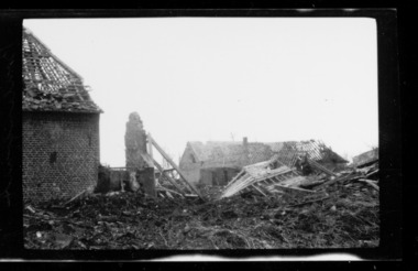
Warrnambool RSL Sub Branch
Photograph - YPRES
... Large photo of Australian soldiers passing through the ruins of Ypres. ...Australian Soldiers passing through the ruins of Ypres to take up a front line....Australian Soldiers passing through the ruins of Ypres to take up a front line. Large photo of Australian soldiers passing through the ruins of Ypres. ...Large photo of Australian soldiers passing through the ruins of Ypres. Australian Soldiers passing through the ruins of Ypres to take up a front line. -
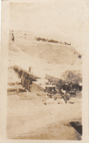
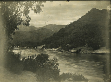 Lakes Entrance Historical Society
Photograph - Derrick Ruins, Rev John Flynn, 1906
... Black and white photograph of view of Deddick River north of Buchan and old Deddick ruins Victoria...Deddick Ruins P36 Johyn Flynn Postcards from Buchan...Lakes Entrance Historical Society 4 Marine Parade Lakes Entrance gippsland This is a photograph proof on light card Deddick Ruins P36 Johyn Flynn Postcards from Buchan Black and white photograph of view of Deddick River north of Buchan and old Deddick ruins Victoria Photograph Derrick Ruins Rev John Flynn ...This is a photograph proof on light cardBlack and white photograph of view of Deddick River north of Buchan and old Deddick ruins VictoriaDeddick Ruins P36 Johyn Flynn Postcards from Buchan -
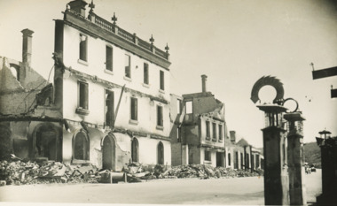
 The Beechworth Burke Museum
Photograph, c. 1918
... ...ruins...Taken in c. 1918, this photograph depicts the ruins of the French village Villers-Bretonneux. ...Reverse: (A copyright and reproduction notice from the Australian War Museum, printed upside-down in blue ink) Church x Ruins/ Villers Bretonneux/ (in pencil) ...The Beechworth Burke Museum Loch Street Beechworth high-country Taken in c. 1918, this photograph depicts the ruins of the French village Villers-Bretonneux. ...Taken in c. 1918, this photograph depicts the ruins of the French village Villers-Bretonneux. In the foreground of the image are rows of shell damaged houses and buildings. In the background of the image stands a tower of the ruined church.On 24 April, Villers-Bretonneux was captured by the Germans as they advanced towards the regional city of Amiens. If they achieved their goal and drove onto the French coast, splitting the British and French armies, the Allied cause might have been lost. The fate of Amiens hung in the balance as two Australian brigades were given the task of retaking Villers-Bretonneux through a swift night-time counter attack. One brigade would assault from the south, while another would attack from the north. The assault began at 10pm on 24 April. The 13th Brigade in the south were held up by German machine guns, before the Australians linked up east of the village. After dawn on 25 April Australian and British troops were involved in fierce fighting to clear the Germans from the village. Some Germans escaped Villers-Bretonneux through nearby woods. Later on the morning of 25 April, three years to the day after the Anzacs landings at Gallipoli, French and Australian flags were raised over Villers-Bretonneux.Black and white rectangular reproduced photograph printed on matte photographic paperReverse: (A copyright and reproduction notice from the Australian War Museum, printed upside-down in blue ink) Church x Ruins/ Villers Bretonneux/ (in pencil) burke museum, world war 1, ww1, wwi, france, australia, villers-bretonneux, ruins, military album -
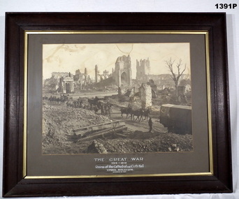 Bendigo Military Museum
Photograph - PHOTOGRAPH WW1, FRAMED, C. WW1
... Heavy wooden frame, brown with khaki border, glass front, sepia photo showing ruins in Ypres Belgium....“The Great War 1914-1919 Ruins of the Cathedral and Cloth Hall Ypres, Belguim October 23 1917”...Bendigo Military Museum 37 - 39 Pall Mall Bendigo goldfields photography - photographs frame accessories military history - souvenirs Ypres cloth hall “The Great War 1914-1919 Ruins of the Cathedral and Cloth Hall Ypres, Belguim October 23 1917” Heavy wooden frame, brown with khaki border, glass front, sepia photo showing ruins in Ypres Belgium. ...Heavy wooden frame, brown with khaki border, glass front, sepia photo showing ruins in Ypres Belgium.“The Great War 1914-1919 Ruins of the Cathedral and Cloth Hall Ypres, Belguim October 23 1917”photography - photographs, frame accessories, military history - souvenirs, ypres, cloth hall -
Glenelg Shire Council Cultural Collection
Photograph - Photograph - Cape Bridgewater School, n.d
... Black and white photo, ruins of Cape Bridgewater school; stone walls, tin roof, half missing, no glass in windows, trees growing over and through the ruins. ...Front: 'Cape Bridgewater School - ruins still there' - handwritten, black biro, across top of photo Back: '13' - top left corner, blue biro...Glenelg Shire Council Cultural Collection History House Cliff Street Portland great-ocean-road Cape Bridgewater school ruin building Front: 'Cape Bridgewater School - ruins still there' - handwritten, black biro, across top of photo Back: '13' - top left corner, blue biro Black and white photo, ruins of Cape Bridgewater school; stone walls, tin roof, half missing, no glass in windows, trees growing over and through the ruins. ...Black and white photo, ruins of Cape Bridgewater school; stone walls, tin roof, half missing, no glass in windows, trees growing over and through the ruins. Barbed wire fence around it.Front: 'Cape Bridgewater School - ruins still there' - handwritten, black biro, across top of photo Back: '13' - top left corner, blue birocape bridgewater, school, ruin, building -
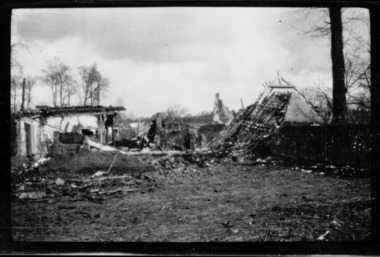
 Lakes Entrance Historical Society
Postcard - Golden Age Hotel Omeo- Black Saturday Fires 1939, Bulmer
... Also a second postcard with a different view of the ruins of Omeo shops Day St Omeo January 1939 05384.1 8.5 x 14 cm...Friday 13 January 1939 showing ruins of the fires...Also a second postcard with a different view of the ruins of Omeo shops Day St Omeo January 1939 05384.1 8.5 x 14 cm Bushfires Natural Disasters Townships Friday 13 January 1939 showing ruins of the fires Black and white postcard showing remains of Golden Age Hotel after Black Saturday Bush fires Omeo Victoria Postcard Golden Age Hotel Omeo- Black Saturday Fires 1939 Bulmer ...Also a second postcard with a different view of the ruins of Omeo shops Day St Omeo January 1939 05384.1 8.5 x 14 cmBlack and white postcard showing remains of Golden Age Hotel after Black Saturday Bush fires Omeo VictoriaFriday 13 January 1939 showing ruins of the firesbushfires, natural disasters, townships