Showing 20 items matching "rural 1 land"
-
 Marysville & District Historical Society
THE TRIANGLE NEWS-VOL 36 NO 37-OCTOBER 2 2009
... ...rural 1 land...Marysville & District Historical Society 39 Darwin Street Marysville yarra-valley-and-the-dandenong-ranges marysville victoria australia late snow still an attraction marysville marathon dr lachlan fraser what's on when in october buxton cfa buxton community hall annual buxton community christmas bbq buxton reserve football in marysville the marysville & district lions club mtcrc report advertisements marysville marquee mobile kitchens my chef mike catering st michael's grammar school all stars band bpa news had enough community support gathering marysville golf club accredited facilitators graeme & julia cann church notices vale christina barton charcoal drawings of christ church and marysville primary school situations vacant waste transfer station community service hub operating hours spring-season of hope and promise marysville medical clinic councillor comment bushfire affected residents to reap solar hot water rebate marysville art show marysville & district football & netball clubs lakeside fellowship evening eildon community centre hall alexandra cinema murrindindi shire council youth development and participation officer mayors chair marysville community market gallipoli park lions triangle tool library marysville community golf & bowls club marysville caravan park your health and wellbeing public notice rural 1 land buxton progress assocn amnesty period on open air burning marysville junior cricket marysville triangle real estate alexandra clearing sale THE TRIANGLE NEWS-VOL 36 NO 37-OCTOBER 2 2009 ...marysville, victoria, australia, late snow still an attraction, marysville marathon, dr lachlan fraser, what's on when in october, buxton cfa, buxton community hall, annual buxton community christmas bbq, buxton reserve, football in marysville, the marysville & district lions club, mtcrc report, advertisements, marysville marquee, mobile kitchens, my chef mike catering, st michael's grammar school all stars band, bpa news, had enough community support gathering, marysville golf club, accredited facilitators graeme & julia cann, church notices, vale christina barton, charcoal drawings of christ church and marysville primary school, situations vacant, waste transfer station, community service hub operating hours, spring-season of hope and promise, marysville medical clinic, councillor comment, bushfire affected residents to reap solar hot water rebate, marysville art show, marysville & district football & netball clubs, lakeside fellowship evening, eildon community centre hall, alexandra cinema, murrindindi shire council, youth development and participation officer, mayors chair, marysville community market, gallipoli park, lions triangle tool library, marysville community golf & bowls club, marysville caravan park, your health and wellbeing, public notice, rural 1 land, buxton progress assocn, amnesty period on open air burning, marysville junior cricket, marysville triangle real estate, alexandra clearing sale -
Clunes Museum
Document - REPORT, HEPBURN SHIRE, 2024
... .1 RURAL HEPBURN - AGRICULTURAL LAND STUDY AND RURAL SETTLEMENT STRATEGY, UNBOUND REPORT PRINTED IN COLOUR ON PAPER, 94 PAGES .2 FUTURE HEPBURN - CLUNES STRUCTURE PLAN, UNBOUND REPORT PRINTED IN COLOUR ON PAPER, 67 PAGES ...Clunes Museum 36 Fraser Street enter building through Collins Place Clunes goldfields PLANNING POLICY PRINCIPLES WILL BE TAILORED TO RESPOND TO LANDSCAPE VARIATION AND DRIVERS OF LAND USE CHANGE AND THE DIFFERENTIAL IMPACT THAT THESE HAVE ACROSS THE SHIRE... HEPBURN SHIRE COUNCIL RURAL SETTLEMENT STRATEGY ADOPTED BY HEPBURN SHIRE COUNCIL 3 SEPTEMBER 2024 .1 RURAL HEPBURN - AGRICULTURAL LAND STUDY AND RURAL SETTLEMENT STRATEGY, UNBOUND REPORT PRINTED IN COLOUR ON PAPER, 94 PAGES .2 FUTURE HEPBURN - CLUNES STRUCTURE PLAN, UNBOUND REPORT PRINTED IN COLOUR ON PAPER, 67 PAGES Document REPORT HEPBURN SHIRE. ...PLANNING POLICY PRINCIPLES WILL BE TAILORED TO RESPOND TO LANDSCAPE VARIATION AND DRIVERS OF LAND USE CHANGE AND THE DIFFERENTIAL IMPACT THAT THESE HAVE ACROSS THE SHIRE....1 RURAL HEPBURN - AGRICULTURAL LAND STUDY AND RURAL SETTLEMENT STRATEGY, UNBOUND REPORT PRINTED IN COLOUR ON PAPER, 94 PAGES .2 FUTURE HEPBURN - CLUNES STRUCTURE PLAN, UNBOUND REPORT PRINTED IN COLOUR ON PAPER, 67 PAGES ADOPTED BY HEPBURN SHIRE COUNCIL 3 SEPTEMBER 2024hepburn shire council, rural settlement strategy -
 Kiewa Valley Historical Society
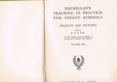
Book - Reference Teaching Infants, MacMillan's Teaching in Practice for Infant Schools Projects and Pictures Vol. 1, 1949
... land". However at this age level fantasy was more important than reality. Australian fantasy tales e.g. Blinky Bill (circa 1930s) introduced main characters that infants could identify, especially in rural schools. infant school curriculum teacher's aid reference instruction book On the spine is "MACMILLANS TEACHING IN PRACTICE" below this "PROJECTS and PICTURES" underneath "VOL 1". ...This item was reprinted in 1949 (first edition in 1934) in Great Britain and used in Victorian Infant school classes.This was in the era where "mother England" was still the favourite source of educational text books for Australian primary schools. "Australianism" was frowned upon by educational institutions as being not proper English. This belief lingered on for a longer period in private schools, where "ockerism" was a dirty word. It was not until the mid 1950s that the Australian dialect and social mores were accepted as suitable for educational activities.This item was used in Mount Beauty Primary School as part of a teacher's curriculum. The fact that it was in a rural area, Kiewa Valley did present a slightly different learning atmosphere than in the larger towns and cities. The majority of parents within the Kiewa Valley, had a slight resentment of the "high and mighty" attitude of city dwellers with a "plum in their mouths" and the effectiveness of city bred teachers was how to overcome these ingrained mores. The mentioning of European nations and lifestyles was to the pupils in the infant schools far more like "fairyland" than the realism that they experienced on the "land". However at this age level fantasy was more important than reality. Australian fantasy tales e.g. Blinky Bill (circa 1930s) introduced main characters that infants could identify, especially in rural schools.This item is a green coloured hard backed book containing 384 double sided pages. Nearly all pages have black writing and free hand sketches. There are some pages of duplicated sheet music.See KVHS 0046, KVHS 0047, KVHS 0048 for the other volumes held.On the spine is "MACMILLANS TEACHING IN PRACTICE" below this "PROJECTS and PICTURES" underneath "VOL 1". On title page "edited by E.J.S.Lay" underneath VOLUME ONE. Below this there is printed a two branch wreath within these an "Olympic" type torch.infant school curriculum, teacher's aid reference, instruction book -
 Kiewa Valley Historical Society
Book - Non Fiction History, Australia's Royal Welcome 1954, circa 1954
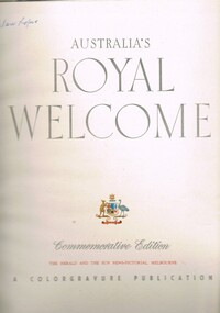
... 1. to attend an assembly of ex-servicemen and women's organisations 2. to attend a Children's Display. She also visited Government House and visited Country Victoria on the Royal train from 24th Feb - 9th March. The Kiewa Valley and all the rural areas in the region were still very much tied to the "mother land ...This publication covers the mid 1900s and relates to a period where the majority of the Australian population was engrossed with the Queen of Australia, even though her Highness did not reside on this continent. The period covered was before the great immigration insurgence from Europe.The Labour Party's "White Australian" policy was a hinderance and a barrier towards the Asian and African prospective immigrants. The motto Queen and Country was still very ingrained in the rural population. This period in Australian domestic self reliance, brought about the growing strength and very active trade union movement and their staunch support for the Tariff protection against a growing swell of imported goods. This self reliance psyche was essentially a by product of World War II, and the isolation felt by the Australian People. The Queen (royalty) was the binding force holding the British Empire together which was emphasised with her popularity when touring Australia Queen Elizabeth's visited the MCG twice in 1954 1. to attend an assembly of ex-servicemen and women's organisations 2. to attend a Children's Display. She also visited Government House and visited Country Victoria on the Royal train from 24th Feb - 9th March.The Kiewa Valley and all the rural areas in the region were still very much tied to the "mother land" and trade between Britain and Australia was very strong. Trade with Asian manufacturers was minimal and needed the late 1900s to see both the trade and immigration barriers fall. This book was produced during a time when the majority of Australians looked more to England for trade and companionship. The agricultural trade with England and Europe was very high and the motto of the time was "Australia grows on the sheep's back". Late 1900's saw the motto "Australia grows on the miner's back" The Queen was still very popular then which was emphasised by the large crowds which greeted her on tour. Residents of Mt Beauty including Cubs, Brownies, Scouts and Guides travelled to Benalla to see the Queen. Clare Roper was a founding member of the KVHS and attended a garden party at Buckingham Palace representing the local CWA. She has purchased this book and therefore giving this a close historical significance connection, it has good provenance and interpretive capacity. This hard(blue coloured) covered book contains thirty six double sided pages. Both the first and last pages (inside cover included) has the royal crest of Australia (kangaroo and emu) balancing the individual six states crests ,united under the royal crown. The first six double pages, each portraying a coloured free hand sketches of various Australian scenery enclosing the Queen's day by day and State by State itinerary. There are 115 black and white photographs and 25 coloured photographs contained in this book.Third page has free hand penned signature "Clare Roper"1954 royal tour, queen elizabeth ii monarchy, british empire in the 1900s, god save the queen. -
 Kiewa Valley Historical Society
Bag Canvas Water, Circa 1950
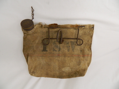
... This extract from an advertisement in the Sydney Morning Herald newspaper of 1/12/1959 places the era in which this water bag was prolific throughout rural Australia. " ABERDEEN CANVAS GOODS for the man on the land here is Australia's most useful, convenient and hygienic water bag. ...Kiewa Valley Historical Society Mount Beauty Information Centre 31 Bogong High Plains Rd Mt Beauty high-country This extract from an advertisement in the Sydney Morning Herald newspaper of 1/12/1959 places the era in which this water bag was prolific throughout rural Australia. " ABERDEEN CANVAS GOODS for the man on the land here is Australia's most useful, convenient and hygienic water bag. ...This extract from an advertisement in the Sydney Morning Herald newspaper of 1/12/1959 places the era in which this water bag was prolific throughout rural Australia. " ABERDEEN CANVAS GOODS for the man on the land here is Australia's most useful, convenient and hygienic water bag. Its special unbreakable plastic nozzle is fitted with a perforated filter strainer. Made from long flax canvas, its universal handle enables it to be hung on bumper bar, wire fence or on hook or nail" The availability of clean cool drinking water in remote rural locations was essential for survival under the blistering Australian summer sun. This was in a pioneer era when transport, roads and convenience stores were ,in a lot of "outback" Australia, in short supply and survival was dependent upon what could be carried by vehicle or pack horse.When the Kiewa Hydro Electricity Scheme became a reality, the use of the water bag was one of the essential personal items of survival given to each person working in the forests and on and in the high plains environment. Even in an outside stationary work place the availability of cool clean water was a prerequisite. The canvas water bag allowed any wind or airflow to cool down the water, even on very hot days, to provide a refreshing and throat quenching supply of water. These bags could be fastened onto the front of vehicles or hanging from shady tree branches thereby permitting air flow around the bag. During the "wearing in" period the residual taste from the canvas was fairly strong, this became considerably less as time and a half moved on. This "Aberdeen" long flax canvas water bag is held together on two sides and the top by strong heavy cotton stitching. The iron fashioned carrying handle has, protruding from its top elevation ,a very strong hook (well in excess of the bags' weight requirement). At the top, of the bag, and on one side only, is a brown coloured bakelite spout (with an inbuilt filter) protruding upwards. This spout has its matching , screw on, lid complete with attachment chain (not fixed at the handle end)On the front of the bad and stenciled in bold lettering, "ABERDEEN" and directly below "Travellers" and below this "FILTER BAG". Below this are two parallel black lines enclosing an ochre coloured band(12mm wide) running around the bottom section of the bag. Below this band is stenciled the number 14 in black (25mm high) figures. The spout lid has stamped on the top surface and within the outline of Australia, "ABERDEEN FILTER WATER BAG". Above this and close to the edge of the lid is pressed "PAT. No 9149/32 and down at the bottom rim is stamped "RD. No. 9870". canvas, water bag, water container, camping equipment, survival pack -
 Kiewa Valley Historical Society
Hat Child's Felt, Circa mid 1900's
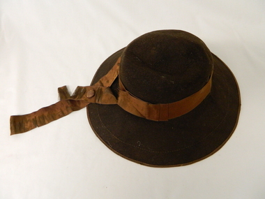
... rural lifestyle and its mores. It clearly demonstrates the coheasive force that religion has on the Valley population. The closeness that the semi isolation (at this time) brought about by the Valley's physical land formation and the poor roads within the valley brought families closer together. Not turning up for important social functionsw was duely noted by all (and frowned upon). Mrs E. Fisher lived at Mongan's Bridge in the Kiewa Valley. children's head wear social head dress church hats 6 and one quarter (size tag). Unreadable crest / monogram Brown child's all felt hat size 6 1 ...This brown wool felt hat with a broad brim was, by its style, used by a adolescent child for church services. This was worn in a period where church services on Sunday was an important weekly ritual by the whole family. Special (church only) dresses and hats were worn not only to show respect to the church but also part of expected community mores relating to religious beliefs. This behavioural pattern was more entrench in the rural communities than within larger cities. The closeness of smaller rural communities is the main factor regarding social norms. The visible standing within the community was uppermost. The period pre 2000 was a more coheasive family environment ( due to greater intra family activities) which provided better communication and family activities.This "church styled" hat is very significant to the rural lifestyle and its mores. It clearly demonstrates the coheasive force that religion has on the Valley population. The closeness that the semi isolation (at this time) brought about by the Valley's physical land formation and the poor roads within the valley brought families closer together. Not turning up for important social functionsw was duely noted by all (and frowned upon). Mrs E. Fisher lived at Mongan's Bridge in the Kiewa Valley.Brown child's all felt hat size 6 1/4. A broad brim with a lighter brown velvet ribbon head band. Head band has a crossover to the left front with 100 mm extension flowing over the brim. The top of the inside of the head pocket is lined with a soft silk fabric.6 and one quarter (size tag). Unreadable crest / monogramchildren's head wear, social head dress, church hats -
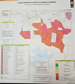 Emerald Museum & Nobelius Heritage Park
Map - Land Capability Study of the Shire of Cardinia - Rural residential Emerald 1996, c1996
... A Land Capability Study of the Shire of Cardinia/Land Capability of Rural residential or Emerald/Centro for land protection research, Bendigo/Legen x 3/Land Capability Classes - 1 to 5...Emerald Museum & Nobelius Heritage Park 5 Crichton Rd Emerald yarra-valley-and-the-dandenong-ranges A Land Capability Study of the Shire of Cardinia/Land Capability of Rural residential or Emerald/Centro for land protection research, Bendigo/Legen x 3/Land Capability Classes - 1 to 5 Image of a map indicating capability study of the Shire of Cardinia - Rural residential Emerald Land Capability Study of the Shire of Cardinia - Rural residential Emerald 1996 Map Land Capability Study of the Shire of Cardinia - Rural residential Emerald 1996 ...Image of a map indicating capability study of the Shire of Cardinia - Rural residential EmeraldA Land Capability Study of the Shire of Cardinia/Land Capability of Rural residential or Emerald/Centro for land protection research, Bendigo/Legen x 3/Land Capability Classes - 1 to 5 -
Glen Eira Historical Society
Article - COANE, JOHN MONTGOMERY
... 1/A one page extract from The Australian Dictionary of Biography Vol. 8 page 35 on John Montgomery Coane, Surveyor and Consulting Engineer, his partnership with George Hudson and later when his two sons joined the business. It details many of the projects he designed for rural Victoria and New South Wales and his other areas including Consulting to The Pacific Phosphate Co. Ltd of London and to the City of Brighton where he lived. Coane John Montgomery Blacker’s Orchard & Cannery Co. Victorian Institute of Surveyors County Donegal Ireland Mordialloc Ballyshannon Mines Department Sludge Abatement Board Coane Henry Edward Surveyors Engineers Land ...This file contains one item about Coane and his family: 1/A one page extract from The Australian Dictionary of Biography Vol. 8 page 35 on John Montgomery Coane, Surveyor and Consulting Engineer, his partnership with George Hudson and later when his two sons joined the business. It details many of the projects he designed for rural Victoria and New South Wales and his other areas including Consulting to The Pacific Phosphate Co. Ltd of London and to the City of Brighton where he lived.coane john montgomery, blacker’s orchard & cannery co., victorian institute of surveyors, county donegal, ireland, mordialloc, ballyshannon, mines department sludge abatement board, coane henry edward, surveyors, engineers, land surveyors board, coane henry james, j.m. and h.e. coane, coane jane nee montgomery, coane john montgomery junior, victorian education department, australian roads, collas emma anna hunt, books, grant george hudson, coutie b.m., state electricity of victoria, melbourne, epsom racecourse, racecourses, brighton, city of brighton, brighton re-adaptation society, brighton cemetery, cemeteries, southern roger j, australian dictionary of biography vol. 8, early settlers -
![Newspaper - Newspaper supplement, Herald and Weekly Times, Our land our century [incomplete], 1999](/media/collectors/4f729f5697f83e03086015b8/items/662a2b23fc51ca3e599bbbb8/item-media/662a2b99fc51ca3e599bbf0f/item-fit-380x285.jpg?cb=6) Greensborough Historical Society
Greensborough Historical SocietyNewspaper - Newspaper supplement, Herald and Weekly Times, Our land our century [incomplete], 1999
... rural life in the 20th century, this series covers each decade. Part 4: The great struggle 1930-1930; Part 5: Keeping the home fires burning 1940-1949; Part 7: Easy Street? 1960-1969; Part 8: A roller coaster ride, 1970-1979; Part 9: Feeling the heat, 1980-1989. Incomplete set, parts 1, 2, 6 and 10 missing. country life australia country life 5 issues of large format newspaper supplement. Our land ...A history of rural life in the 20th century, this series covers each decade. Part 4: The great struggle 1930-1930; Part 5: Keeping the home fires burning 1940-1949; Part 7: Easy Street? 1960-1969; Part 8: A roller coaster ride, 1970-1979; Part 9: Feeling the heat, 1980-1989. Incomplete set, parts 1, 2, 6 and 10 missing.5 issues of large format newspaper supplement.country life, australia country life -
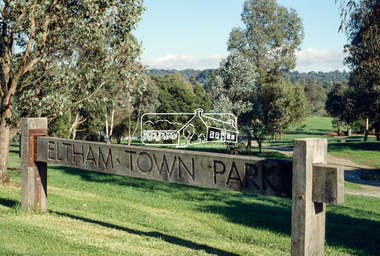 Eltham District Historical Society Inc
Slide - Photograph, Eltham Town Park, c.May 1988
... land within the area over the years included Lyon, Rees, Clark, Waterfall, Carrucan, Graham, Hill and Morant. The character of the valley area has remained rural while development occurred on each side. Early photos show the area as orchard and grazing land. In 1901 the railway was constructed through the area resulting in the timber trestle bridge across the Diamond Creek. which is an important feature of the park landscape. A memorial obelisk to the Eltham servicemen killed in World War 1...land within the area over the years included Lyon, Rees, Clark, Waterfall, Carrucan, Graham, Hill and Morant. The character of the valley area has remained rural while development occurred on each side. Early photos show the area as orchard and grazing land. In 1901 the railway was constructed through the area resulting in the timber trestle bridge across the Diamond Creek. which is an important feature of the park landscape. A memorial obelisk to the Eltham servicemen killed in World War 1 ...In 1981 the Shire of Eltham Historical Society was asked by the Victorian Place Names Committee to comment on a proposal by the Shire of Eltham to assign names to parklands in Eltham as follows:- "Eltham Common" - the area between the municipal offices, Main Road, the Eltham railway -line, and Panther Place and containing Shillinglaw Cottage. The Shire has advised that this name has been used locally for the site since about 1975. "Alistair Knox Park" - the area bounded by the Eltham railway -line, Panther Place, Main Road, Bridge Street, and Susan Street, and through which flows the Diamond Creek. The area has been known locally as "Eltham Town Park" The proposed name "Alistair Knox Park" had created some local controversy with a number of reversals of the Council's decision and letters to the local paper both for and against the proposal. The society was reluctant to be drawn into this controversy particularly as there were known to be members with strong views both for and against the proposed name. The society appreciated the work done by Alistair Knox both in the formulation of the park concept and in its development but because of the controversy generated by the proposed naming and also because of the wide general use of the park by the public·, the name Eltham Town Park was felt more appropriate. The society noted that there was no outstanding historical associations with the land comprising the park which would warrant naming the park after any particular person, place or event. No objection was raised to the Eltham Common proposal as set-out above. The decision was made in the knowledge that Alistair Knox had been associated with the society over many years and was a prominent figure in the recent history of Eltham. He was regarded as a key figure in the environmental building movement and in particular was renowned for his use of mud bricks as a building material. He served as a councillor of the Shire of Eltham from 1971-1975, his final year as Shire President. It was during these years that the proposals to create the park in its present form were shaped and Alistair played a leading part in the decision to make it a landscaped passive recreational park rather than a sporting area. The parklands comprise a section of the Diamond Creek valley. The creek itself flows through the centre of the area which is overlooked by steep hills on each side. The parks form part of the land purchased from the Crown in 1851 by J.M. Holloway and then subdivided into allotments and called "Little Eltham". While most of the area was subdivided into residential lots the creek valley was subdivided into lots suitable for small farms. Some further subdivision took place over the years and the whole of the parks now comprises eight separate titles. A list of some of the former owners has been compiled but exhaustive research on all owners has not been carried out. The ownership of one parcel has been traced back to when it was purchased from Holloway by John Hicks Petty in 1874, long after it was subdivided. Other families owning land within the area over the years included Lyon, Rees, Clark, Waterfall, Carrucan, Graham, Hill and Morant. The character of the valley area has remained rural while development occurred on each side. Early photos show the area as orchard and grazing land. In 1901 the railway was constructed through the area resulting in the timber trestle bridge across the Diamond Creek. which is an important feature of the park landscape. A memorial obelisk to the Eltham servicemen killed in World War 1 was erected at the south eastern corner of the park. The site is now within the intersection of Main Road and Bridge Street and the memorial was shifted in the 1950s to the Eltham R.S.L. clubrooms. Following the financial failure of the local sub-branch, the memorial obelisk was again relocated to the Eltham War Memorial building precinct in 2011. During the early 1960's the Council started purchasing the land which now comprises the parks. In the late 1960's the area to the east of the Diamond Creek was used as a garbage tip and filled above the flood plain of the creek. When this area was filled the tip was transferred to the west side of the creek. From the early 1970's the area has been progressively developed as a park for passive recreation with ornamental lakes, extensive tree planting and landscaping. The character of the valley before the days of the tip has been recreated and this has earned a Landscape classification from the National Trust, an unusual honour for a man-made landscape. The parks are not only attractive in appearance. The large number of people using them, particularly at weekends and holidays is evidence of their popularity and the foresight and careful planning of local residents, Councillors and Council Staff. 35mm colour positive transparency (1 of 23) Mount - Kodak EktachromeProcess Date MAY 88Meltham, main road, alistair knox park, eltham town park -
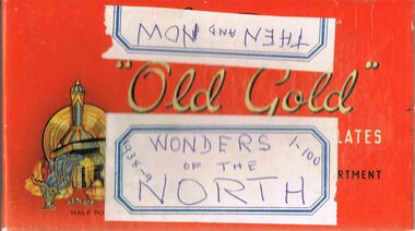 Bendigo Historical Society Inc.
Newspaper - LYDIA CHANCELLOR COLLECTION: WONDERS OF THE NORTH. FAMOUS PEOPLE
... History House 11 Mackenzie Street Bendigo goldfields PLACE Land rural life Lydia Chancellor collection Australia place Aboriginal Australian Aborigines Aborigines Northern Australian Australian flora Australian fauna fauna flora plants Australian plants Australian animals animals Australian lighthouses lighthouses sciences botany tourism famous people male person Wonders of the north 1-100 1938-9 Then and Now 'A small orange Old Gold chocolate box containing 2 newspaper columns. ...'A small orange Old Gold chocolate box containing 2 newspaper columns. (i) Wonders of the North' series 1-100. 1938-1939. (ii). This series of clips contains references to Aboriginal/Indiginous people. 'Then and Now Public Men'. These clips have a young/older photo and the positions they held in their professional life. Both columns from the 'Sun-News Pictorial' newspaper.Wonders of the north 1-100 1938-9 Then and Nowplace, land, rural life, lydia chancellor, collection, australia, place, aboriginal, australian aborigines, aborigines, northern australian, australian flora, australian fauna, fauna, flora, plants, australian plants, australian animals, animals, australian lighthouses, lighthouses, sciences, botany, tourism, famous people, male, person -
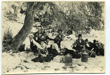 Orbost & District Historical Society
black and white photograph, January 1, 1897
... 1, 1897. Late in 1857 Mr Thomas T. Stirling took over Corringle Run ("Corringle" means "shallow water"). Mr Stirling and his family came from the wester district - Winchelsea. He settled at the Old Station. A few people were employed at the Orbost Stationb and there was settlement on the Orbost flats, Mr T. T. Stirling held the land from Lake Tyrers to Bemm River as a cattle run. About 1888 he became Secretary of the new Tambo Shire. This photograph is a portrait of rural ...This photograph shows Mr John Bird ( 3rd from left) ; Mr John Gilbert and Mr Lance Herbert among others having a picnic at the popular beach paddock at Old Station, Corringle, on January 1, 1897. Late in 1857 Mr Thomas T. Stirling took over Corringle Run ("Corringle" means "shallow water"). Mr Stirling and his family came from the wester district - Winchelsea. He settled at the Old Station. A few people were employed at the Orbost Stationb and there was settlement on the Orbost flats, Mr T. T. Stirling held the land from Lake Tyrers to Bemm River as a cattle run. About 1888 he became Secretary of the new Tambo Shire.This photograph is a portrait of rural life in the late 19th century. It is an insight into the dress, manners and activities of the first settlers of Orbost.Two copies of a black / white photograph of a group of men and women picnicking on the sand under tall trees.on back - "Beach Paddock - Old Station -1897" with a list of namesold-station-orbost rural-family-life -
 Federation University Historical Collection
Magazine - Booklet, University of Ballarat, Everyone@UB, 2001
... In 1998 Everyone@UB was a monthly staff newsletter edited by Peter Baird in consultation with Don Moconachie. university of ballarat ballarat school of mines wetland broadband david janes smb kennett leadership eagles centre for rural and regional health microwave turale arts academy camp street library landcare mallee mallee pipeline barry verna barry mills brown palmer caro geoffrey blainey blainey birkin besse kemmis adermann ackland jardine auld mclaren pope green otago radomski honorary doctorate munt stepcich wemyss rubinov muir everyone@ub robinson horsham stawell ararat fukuoaka taylor moneghetti coutt hatfeild westbrooke karan bailey james nemeth wild de bono texas sharpam fiji clark ruyg kropp sugget baird allen westbrook rural health stacpoole mcgrath ruglen ferrier manterfield pilven michael adermann tafe mount helen vegetation Dennis Arne A series of monthly bulletins covering all University of Ballarat campuses. .1) University merger, John Bailey, Michael Adermann, Vice-Chancellor, Jenny Nemeth, Katherine Birkin, Rowena Coutts, Ballarat Technology Park, Ron Wild .2) Chancellor appointment, Chancellor retirement, Geoffrey Blainey tribute, David Caro, Katherine Birkin, Arno Besse, George Murdoch, Bullarook, Stephen Kemmus, Neville French, ceramics, Tristan Smith, Horsham, Arnhem Land film, Ararat, Kerry Cox, anorexia, salary packages, University of Ballarat Brass Band, Natalie Radomski, becoming a university. ...The University of Ballarat in 1998 comprised the Mt Helen Campus, SMB (Ballarat School of Mines) Campus and the Horsham Campus. It's current name is Federation University Australia. In 1998 Everyone@UB was a monthly staff newsletter edited by Peter Baird in consultation with Don Moconachie.A series of monthly bulletins covering all University of Ballarat campuses. .1) University merger, John Bailey, Michael Adermann, Vice-Chancellor, Jenny Nemeth, Katherine Birkin, Rowena Coutts, Ballarat Technology Park, Ron Wild .2) Chancellor appointment, Chancellor retirement, Geoffrey Blainey tribute, David Caro, Katherine Birkin, Arno Besse, George Murdoch, Bullarook, Stephen Kemmus, Neville French, ceramics, Tristan Smith, Horsham, Arnhem Land film, Ararat, Kerry Cox, anorexia, salary packages, University of Ballarat Brass Band, Natalie Radomski, becoming a university. Images: Geoffrey Blainey, David Caro, David James, Katherine Birkin, Arno Besse, George Murdoch, Geoffrey Blainey, Stephen Kemmis, Neville French, John Ackland, Richard Jardine, Glen Auld, Dennis Arne, Andrew Kotsonis, Kerry Cox, Suzanne McLaren, Marcia Pope, Rosemary Green, Leonie Otago, Natalie Rodomski .5) October 1998 - Carolyn Taylor, misogyny, Horsham campus building under construction, David Caro, Miranda Kerr, Martin Westbrook, Iain Reid, virtual monitors, teaching practice, Joanne Knight, John Pidgeon, Sally Buckland, arsenic, Ian Rae, Bob Allan, Patricia Cartwright, Matthew Baker, Sundru Sivamalai, Janine Smith, Pat Mann, International Student Market Research, Steve Mennen, Copyright, internet to the outback, Charters Towers, Engineering students, Darryl Dyason, Andrew McDougall, Dianne Jacono, Ross Morgan, Keith Boast, Cranbrook Academy of Art (Detroit), Helmut Stenzel, Mt Helen vegetation, Jan Bedggood, Ann-Maree Haintz, Kathleen Lakey, Adrienne Ryan, Fiona Schmidt. .11) Phil Candy, flexible learning, strategic planning. .12) diving, Reconciliation, Learning City, Student residence, Alex Rubinov, Graduate Centre, Ceramics, horse, Wimmera, tree regeneration, student poverty, UB museum, David Manterfeild, Heather Hatfeild. Redundancy, video conferencing Images: Steve Matthews, Craig Holloway, Peter Pilven, Sneha Kirubakaran, Phil Honeywood, Kerry Cox, David Manterfield, Martin Westbrooke, Ram Karan, Barry Jones, Gael Ramsay, Jenny Hargave, Heather Hatfield. .16) Jeff Kennett, Honorary Doctorate, Technology Park, Mary Atkinson, Ian Wright, Internet, Disability Action Plan, Robert Munt obituary, Sandra Stepcich obituary, Virginia Fenwlon, East Timor, Centre for Environmental Management, Wayne Jolly, 130th anniversary, Craig Hurley, Barry Wemyss, John Murray, Tori Power, Grant Curnow. Images: Vivienne Witwer, Claire Hetherington, Ian Wright, Virginia Fenelin .17) Broadband, AARNet, David James Retirement, wetlands, Debbie Eagles, Centre for Rural and Regional Health, numeracy, nursing, Sue Turale, Max Palmer, Camp Street, Arts Academy, library, SMB scholarship, Landcare, Mallee pipeline, Verna Barry, Alice Mills, Marian Brown, .18) Fiji, Texans, Greenhill, Robert Whitson, Ian Clark, Abororiginal history, Yuille St, Peter Baird, Martin Westrbrook, Robert Allen, Arts Academy, John McGrath, Phil Ruglen, 3BBB, John Ferrier .21) Beverley. Lassiter, Vice-ChAncellor appointment, Kerry Cox, Craig Hurley, Barry Wemyss, Ceramics, Bill Pryor, University Games, Olympics, Broken Hill, Alex Rubinov, Jonathan Halls, Dare to be different, Wayne Muir, Student Union Refit. Images: Wayne Muir, Alex Ruminov, Kerry Cox .22) December 2000 - nursing, David James, Phil Candy, John McLean, Debbie Eagles, brewery, brewing, Meredith Sussex, Lyn Faneco, TAFE,Joy Nunn, ARC, mosaics, Timor, Alfredo Pires, Centre for Rural and Regional Health, diabetes, kangaroos, Murray-Darling, Leagher Homestead, David Welch, Joy Nunn, Jill Blee, Maryanne Coutts, positive discrimination, Theresa Saunders, Imelda Crebbin .23) March 2001 - Nancy Lange, Paul Lambeth, Yvonne Button, Don Pennell, Natalie Radomski, Marcia Pope, McKinnon Walker, Marc Brodie, TAFE, WorldSkills, Horticulture, Ararat, Website, library, Leeanne Pitman, Liz Hartmann, nursing, Miranda Walker, Ciaran Pier, Anxiety Disorders, volcano, brewing, beer, Peter Aldred, Rob Greig, Jeremy Smith, Alice Mills, Geoff Burgess, .24) May 2001 - Graduations, Talia Venn, Stephen Carthew, Honory Doctorate, Steve Monaghetti, Heather Moore, Brendan O'Brien, Bill Pryr, Terry O'Brien, Carole Wilson, Carolyn Taylor, rape law reform, Federation at the Ballarat School of Mines, Work Skills, Debbie Eagles, Sue Purtle, Longerenong, Mohair, Early Childhood, Horsham, Kerry Cox, Willy Hobbs, David Firth, Kim Durban, BAPA, maryanne Coutts, Ewen McDonald, butterflys, Fukuoaka INstitute of Technology, Jane Wilkinson .25) Wayne Robinson, Neil McAdam retirement, Anne Beggs Sunter, nursing, Eileen Sellers, Hannelore Best, international nursing, Francis Adams, copyright, Roy Taylor, Wendy Bolger, unplugged, Horsham, Robert Irvine, Horsham graduations, Anxiety Clinic, Carole Wilson, Heart Mat, University of Ballarat Mission, Diabetes, Emelia Martinez-Brawley. Images include Wayne Robinson, Anne Beggs Sunter, Eileen Sellers, Hannelore Best, Phil Candy. Meg Tasker, Roy Taylor, Wendy Bolger, Robert Irvine, Angus McLachlan, Roger Castleman, Stephen Roberts, Philip Smith, Bob Allen, Rob Greig, Dennis Jeandet, Carole Wilson, Doug Lloyduniversity of ballarat, ballarat school of mines, wetland, broadband, david janes, smb, kennett, leadership, eagles, centre for rural and regional health, microwave, turale, arts academy, camp street, library, landcare, mallee, mallee pipeline, barry, verna barry, mills, brown, palmer, caro, geoffrey blainey, blainey, birkin, besse, kemmis, adermann, ackland, jardine, auld, mclaren, pope, green, otago, radomski, honorary doctorate, munt, stepcich, wemyss, rubinov, muir, everyone@ub, robinson, horsham, stawell, ararat, fukuoaka, taylor, moneghetti, coutt, hatfeild, westbrooke, karan, bailey, james, nemeth, wild, de bono, texas, sharpam, fiji, clark, ruyg, kropp, sugget, baird, allen, westbrook, rural health, stacpoole, mcgrath, ruglen, ferrier, manterfield, pilven, michael adermann, tafe, mount helen vegetation, dennis arne -
 Surrey Hills Historical Society Collection
Photograph, Surrey Hills Post Office
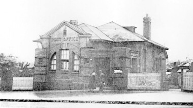
... rural community of scattered farms. Land subdivisions soon occurred along the railway line and limited postal services followed soon after, although a ‘permanent’ home for the post office was two decades away. George Sim Junior is acknowledged as our first postmaster; he opened a post office on 1...rural community of scattered farms. Land subdivisions soon occurred along the railway line and limited postal services followed soon after, although a ‘permanent’ home for the post office was two decades away. George Sim Junior is acknowledged as our first postmaster; he opened a post office on 1 ...The post office opened at this location in 1912. It was demolished in 2000. Post office history in the area: Until 1883 when the railway came through to Surrey Hills, this was essentially a rural community of scattered farms. Land subdivisions soon occurred along the railway line and limited postal services followed soon after, although a ‘permanent’ home for the post office was two decades away. George Sim Junior is acknowledged as our first postmaster; he opened a post office on 1 October 1884 in his father’s general store at 619-621 Canterbury Road, a few doors down from the Surrey Hills Hotel on the corner of Union Road. Over the next 20 years, the Surrey Hills Post Office moved several times into temporary, shared accommodation – in 1889 into Woodhead’s Corner Store at 364 Canterbury Road; then in 1895 to No 376, Hansen’s Exchange Building, part of Hansen’s Terrace (demolished) and in 1901 to 109 Union Road, on the corner of Windsor Crescent. Following Federation in 1901, the new Commonwealth Government established the Postmaster-General's Department to provide postal services to the nation. Many of the post offices constructed in the following years reflected a growing sense of Australian pride and nationalism. It was 1914 when building commenced on the ‘purpose-built’ post office at 609 Canterbury Road, Surrey Hills. Described as “a polychromatic Federation Freestyle building”, it served as the local post office for nearly 85 years until sold by the Commonwealth Government in c1999, after which the post office moved to the current, less prominent site at 100 Union Road. For nearly 10 years under private ownership, the building was successfully adapted for use as the base for two businesses, Gargoyles and Dragons and later the Surrey Sculpture Studio, and fortuitously the historic integrity of the building was maintained. However although renovated in the 1990's, structurally sound and of historic significance, it was not protected under local or commonwealth heritage legislation and was demolished soon after sale. This is an early image of a demolished building which should have been protected. In 1991, when the City of Camberwell conducted a heritage study, (which still informs the basis of the City of Boroondara’s heritage guidelines for this part of the municipality,) the post office was owned by the Commonwealth Government. As such, it could not be considered for heritage listing by the local authorities. Some years later, the Commonwealth and Australia Post rather belatedly recognized not only that post offices have heritage and social value, but also that the architecture of post offices as community buildings is important. A heritage management scheme was developed for the buildings they own or control under the Environment Protection and Biodiversity Act 1999. Unfortunately, the Surrey Hills Post Office had been sold and demolished before this was finally enacted in 2004. Black and white image, perhaps from a post card, of Surrey Hills post office at 609 Canterbury Road. The building is flanked by a picket fence. There is a woman, a dog and a man in front of the entrance. The man is in uniform - possibly a postal employee.post offices, canterbury road, businesses, surrey hills post office, surrey sculture studio, gargoyles and dragons -
Koorie Heritage Trust
Book, Abdulla, Ian W, As I grew older : the life and times of a Nunga growing up along the River Murray, 1993
... 1 & 3, Yarra Building Federation Square, Melbourne melbourne Abdulla Ian W. 1947-2011. | Aboriginal Australians -- Murray River Region (N.S.W.-S.A.) -- Biography. | Aboriginal Australians -- South Australia -- Juvenile literature. | Aboriginal Australians in art -- Juvenile literature. | Painting Aboriginal Australian -- South Australia -- Juvenile literature. | Murray River Region (N.S.W.-S.A.) -- Biography. | Australian As I Grew Older affirms the culture of rural Aborigines who, despite being dispossessed, have been determined to stay onb their own land ...As I Grew Older affirms the culture of rural Aborigines who, despite being dispossessed, have been determined to stay onb their own land. The painting of Ian Abdulla offer us a window on to the life of an Aboriginal Family on the Murray River in the mid-twentieth century.40 unnumbered pages : colour illustrations, 1 colour map ; 26 x 31 cm.As I Grew Older affirms the culture of rural Aborigines who, despite being dispossessed, have been determined to stay onb their own land. The painting of Ian Abdulla offer us a window on to the life of an Aboriginal Family on the Murray River in the mid-twentieth century.abdulla, ian w., 1947-2011. | aboriginal australians -- murray river region (n.s.w.-s.a.) -- biography. | aboriginal australians -- south australia -- juvenile literature. | aboriginal australians, in art -- juvenile literature. | painting, aboriginal australian -- south australia -- juvenile literature. | murray river region (n.s.w.-s.a.) -- biography. | australian -
Koorie Heritage Trust
Book, Behrendt, Larissa, Aboriginal Dispute Resolution, 1995
... 1 & 3, Yarra Building Federation Square, Melbourne melbourne Law - Indigenous - Dispute management | Law - Relation to Anglo Australian law | Law enforcement | Social organisation - Elders | Aboriginal Australians -- Legal status laws etc. | Arbitration and award -- Australia. | Aboriginal Australians -- Land tenure. | Dispute resolution (Law) -- Australia. Discusses the importance of Indigenous communities being able to implement their own models of dispute resolution which take into account traditional values and decision-making structures; proposes a model which could be adapted for use in traditional, rural ...Discusses the importance of Indigenous communities being able to implement their own models of dispute resolution which take into account traditional values and decision-making structures; proposes a model which could be adapted for use in traditional, rural and urban communities.115 p. : ill. ; 20 cm.Discusses the importance of Indigenous communities being able to implement their own models of dispute resolution which take into account traditional values and decision-making structures; proposes a model which could be adapted for use in traditional, rural and urban communities.law - indigenous - dispute management | law - relation to anglo australian law | law enforcement | social organisation - elders | aboriginal australians -- legal status, laws, etc. | arbitration and award -- australia. | aboriginal australians -- land tenure. | dispute resolution (law) -- australia. -
 City of Greater Bendigo - Civic Collection
Newspaper, Shire of Marong, Upfront, c 1989
... On 1 October 1915, the Borough of Raywood, which was gazetted on 17 January 1865 on 23.31 square kilometres of land 28 kilometres north of Bendigo was united with Marong. On 1 October 1990, the Shire of Marong became a rural...On 1 October 1915, the Borough of Raywood, which was gazetted on 17 January 1865 on 23.31 square kilometres of land 28 kilometres north of Bendigo was united with Marong. On 1 October 1990, the Shire of Marong became a rural ...Marong was first incorporated as a road district on 27 August 1861, and became a shire on 23 December 1864. On 1 October 1915, the Borough of Raywood, which was gazetted on 17 January 1865 on 23.31 square kilometres of land 28 kilometres north of Bendigo was united with Marong. On 1 October 1990, the Shire of Marong became a rural city, under the Local Government Act 1989. In a report on 17 February 1994, the Local Government Board recommended that the five councils in the Bendigo region merge to form a "super city", with a population of about 81,000. Marong, Eaglehawk and Huntly had earlier objected to the proposal, and the Board noted a weak no vote against the merger proposal in a referendum in the region; about 70% had voted against, but with a turnout of between 30% and 40% of eligible voters. The three councils filed a writ in the Supreme Court, alleging failure to follow process by the Minister for Local Government, Roger Hallam, but by the time the new "super city" was announced, the writ had not yet been heard, and on 24 March 1994, the Rural City of Marong successfully applied for an injunction blocking the publication of the gazette the following day abolishing the five councils and appointing three commissioners. The government responded by introducing legislation, the City of Greater Bendigo Bill 1994, to Parliament, to effectively override the Supreme Court action, with Hallam saying "the bill would make clear that the Government is determined to achieve its objective for a more efficient municipal structure for the Bendigo region." Marong mayor Robert Hynes described the action as "terribly disappointing", adding, "One way or another, I believe it does mean an end to our fight... it seems the Government are above the law to me." On 6 April 1994, Marong voted to drop the Supreme Court action, effectively in doing so voting itself out of existence, and on 7 April 1994, the Rural City of Marong was abolished, and along with the City of Bendigo, the Borough of Eaglehawk and the Shires of Huntly and Strathfieldsaye, was merged into the newly created City of Greater Bendigo. On 29 April 1994, the Minister confirmed the Bill was not being proceeded with. https://en.wikipedia.org/wiki/Rural_City_of_MarongEight page newspaper style council newsletter providing community updates, news and information. shire of marong, city of greater bendigo amalgamation, councillor phillip eddy, rural city of marong -
City of Kingston
Photograph - Colour, 29 January 1993
... land was converted to residential dwellings. In 1973 investigations commenced nearby to Bonbeach and Carrum into the development of a unique residential area comprising canals and waterways. It was originally proposed to be known as "Gladesville". Circa 1974, the area was rezoned from rural to residential and named Patterson Lakes. Development has been continuous since the 1970s with staged construction of the waterways, residential housing, and supporting infrastructure and facilities. Bonbeach Carrum Patterson Lakes Patterson River Carrum Carrum Swamp Canals and waterways Black type on white adhesive sticker: No. 6661 Black type on white adhesive sticker: 26E/6661, 29/1 ...Bonbeach, Carrum and Patterson Lakes are suburbs in the City of Kingston. Bonbeach and Carrum were holiday destinations in early 20th century and over time the housing has converted to permanent residential structures. In Patterson Lakes, the area consists predominantly of newer housing developments and the tidal canal system which is accessible to many dwellings joins Port Phillip Bay.Bonbeach, Carrum and Patterson Lakes were previously part of the extensive Carrum Carrum Swamp. The area was once a source of fish and eels for the Mayone-Bulluk clan of the Bunurong people. Over time the area was drained and this allowed farming at Carrum and Bonbeach, although the area was prone to flooding. In the early 1920s and 30s the land was converted to residential dwellings. In 1973 investigations commenced nearby to Bonbeach and Carrum into the development of a unique residential area comprising canals and waterways. It was originally proposed to be known as "Gladesville". Circa 1974, the area was rezoned from rural to residential and named Patterson Lakes. Development has been continuous since the 1970s with staged construction of the waterways, residential housing, and supporting infrastructure and facilities.Laminated colour aerial photograph of the Bonbeach, Carrum and Patterson Lakes region within City of Kingston. This 1993 image includes Bonbeach High School prior to demolition, Bonbeach Primary School and Patterson River Golf Club. Sections of Patterson Lakes are not yet developed, including Rhode and Staten Islands. Long Island Point appears to be a recent development with many spare blocks and new houses under construction. The Patterson River marina is prominent and the river mouth as it meets Port Phillip Bay. The Carrum railway station is visible.Black type on white adhesive sticker: No. 6661 Black type on white adhesive sticker: 26E/6661, 29/1/93, 4.25 pm Black type on white adhesive sticker 29-1-93 Yellow circular adhesive stickerbonbeach, carrum, patterson lakes, patterson river, carrum carrum swamp, canals and waterways -
 Bendigo Historical Society Inc.
Slide - Back to Marong Celebrations, c1960-1963
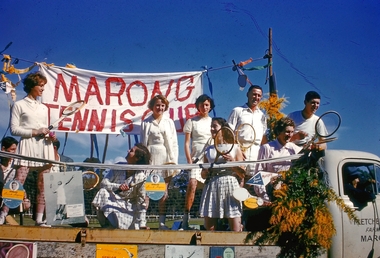
... On 1 October 1915, the Borough of Raywood, which was gazetted on 17 January 1865 on 23.31 square kilometres (9.00 sq mi) of land 28 kilometres (17 mi) north of Bendigo,[2] was united with Marong. On 1 October 1990, the Shire of Marong became a rural...On 1 October 1915, the Borough of Raywood, which was gazetted on 17 January 1865 on 23.31 square kilometres (9.00 sq mi) of land 28 kilometres (17 mi) north of Bendigo,[2] was united with Marong. On 1 October 1990, the Shire of Marong became a rural ...Marong was first incorporated as a road district on 27 August 1861, and became a shire on 23 December 1864. On 1 October 1915, the Borough of Raywood, which was gazetted on 17 January 1865 on 23.31 square kilometres (9.00 sq mi) of land 28 kilometres (17 mi) north of Bendigo,[2] was united with Marong. On 1 October 1990, the Shire of Marong became a rural city, under the Local Government Act 1989. On 7 April 1994, the Rural City of Marong was abolished, and along with the City of Bendigo, the Borough of Eaglehawk and the Shires of Huntly and Strathfieldsaye, was merged into the newly created City of Greater Bendigo.Twelve slides taken for the Back to Marong celebration about 1960-63 possibly at the Marong Recreation (Football) ground. Slides include a float with members of the Marong tennis club, a family group, a float depicting old school days, horse and carts, ladies and men dressed in period costumes and Miss 'Golden North'.history, bendigo, back to marong, city of greater bendigo, rural city of marong, marong tennis club, carl tracey collection -
 Bendigo Historical Society Inc.
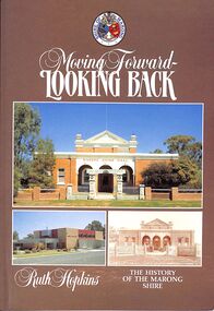
Book - "Moving Forward - Looking Back", 1985
... 1 October 1915. Lockwood was the shire’s administrative centre until 1908, when the centre was transferred to Marong. Marong municipality was served by two railway lines from Bendigo: north-westerly to Bridgwater-on-Loddon (1876) and northerly to Raywood and Pyramid Hill (1882). The Calder and Loddon Valley highways run generally north-west through the former municipality, through undulating to flat terrain, suitable for cereal growing and grazing. South of the Calder Highway the land is undulating to gullied. At the far south-west the Laanecoorie Reservoir lies on the Loddon River. In 1994 Marong rural...1 October 1915. Lockwood was the shire’s administrative centre until 1908, when the centre was transferred to Marong. Marong municipality was served by two railway lines from Bendigo: north-westerly to Bridgwater-on-Loddon (1876) and northerly to Raywood and Pyramid Hill (1882). The Calder and Loddon Valley highways run generally north-west through the former municipality, through undulating to flat terrain, suitable for cereal growing and grazing. South of the Calder Highway the land is undulating to gullied. At the far south-west the Laanecoorie Reservoir lies on the Loddon River. In 1994 Marong rural ...Marong Shire (1864-1994), immediately west and north of Bendigo, was proclaimed on 23 December 1864. Its western boundary was the Loddon River and its eastern boundary enclosed Kangaroo Flat which after World War II had a population of about 1000 persons. By 1990 Kangaroo Flat had an estimated population of about 10,000, thus giving the shire a pronounced urban component. Accordingly, the shire was proclaimed a rural city on 1 October 1990. Marong shire had a mixture of agricultural districts, eucalypt forests and mining localities. There was gold mining at Maiden Gully, Wilson’s Reef near Marong, Neilborough and Sebastian. The mining borough of Raywood was united with the shire on 1 October 1915. Lockwood was the shire’s administrative centre until 1908, when the centre was transferred to Marong. Marong municipality was served by two railway lines from Bendigo: north-westerly to Bridgwater-on-Loddon (1876) and northerly to Raywood and Pyramid Hill (1882). The Calder and Loddon Valley highways run generally north-west through the former municipality, through undulating to flat terrain, suitable for cereal growing and grazing. South of the Calder Highway the land is undulating to gullied. At the far south-west the Laanecoorie Reservoir lies on the Loddon River. In 1994 Marong rural city, with an area of 1489 sq km, had about 9000 cattle, 240,000 sheep and lambs and 11,000 pigs. About 6800 tonnes of barley and 27,000 tonnes of wheat were harvested. On 7 April 1994, Marong rural city was united with Bendigo city, Eaglehawk borough and Huntly and Strathfieldsaye shires to form Greater Bendigo city."Moving Forward - Looking Back" by Ruth Hopkins. Published for the Shire of Morong, Victoria 150th Anniversary Committee, by C G P Printing and Publishing, Bendigo. Printed in 1985. Soft cover book. Front cover is dark fawn brown in color with three photographs inset. Title and author's name in white on front cover and spine. Shire of Marong crest on front cover. Contains map of the then Marong Shire. Covers the history of Marong Shire. 119 pp. Contains both text and black and white images. ISBN 0949248037. shire, marong shire, kangaroo flat, marong