Showing 46 items matching "sand mining"
-
 Bendigo Historical Society Inc.
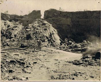
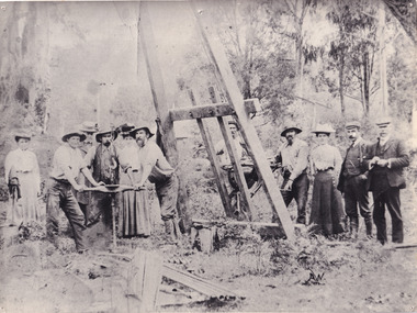
Photograph - Sand mining at the Whipstick
... Sand mining at the Whipstick....Sand Mining... Sand mining at Old Tom mine the Whipstick, Eaglehawk. ...The mine closed c. 1901. Sand Mining Whipstick Old Tom Mine Sand mining at Old Tom mine the Whipstick, Eaglehawk. ...Old Tom mine included quartz mining and open cut mining. Today the remains of the battery site, cyanide plant, hydrolic sluicing and a 1930's puddler can be seen. It was operating in August 1874 and was taken over in 1897 by an English syndicate, J. R. Syndicate. By 1899 the mine had reached 500 feet in depth . The mine closed c. 1901. Sand mining at Old Tom mine the Whipstick, Eaglehawk. O'Halloran's team of nine men and two horses and carts. Two men with horse and carts; and seven men on top of the sand deposit. A4 copy of 1513 Box 25sand mining, whipstick, old tom mine -
 Bendigo Historical Society Inc.
Photograph - WORKERS ON OLD TOM SANDHEAP
... ...Old Tom Sand heap... Mining...History House 11 Mackenzie Street Bendigo goldfields PERSON Group group of workers Old Tom Sand heap Mining Workmen Horse and Buggies O'Halleran's Team A Levy & Co Sepia toned photograph of Workers on Old Tom 'Sand heap O'Halloran's Team' Markings on photo read 'A. ...Sepia toned photograph of Workers on Old Tom 'Sand heap O'Halloran's Team' Markings on photo read 'A. Levy & co' Within the photo are 2 horses and carts as well as 9 male workers. Old Tom Mine in Whipstick, Eaglehawk.A Levy & Coperson, group, group of workers, old tom sand heap, mining, workmen, horse and buggies, o'halleran's team -
 Bendigo Historical Society Inc.
Document - MCCOLL, RANKIN AND STANISTREET COLLECTION: PHOTOGRAPHS - MONUMENT HILL MINE, c1950's
... ...gold mining...sand...History House 11 Mackenzie Street Bendigo goldfields Monument Hill Gold Mine Bendigo gold mining sand tailings MCCOLL RANKIN & STANISTREET Photographs: Folder contains photos - see attached Monument Hill Mine. ...Photographs: Folder contains photos - see attached Monument Hill Mine. Earthmoving sandy tailings heap 1950's.MCCOLL RANKIN & STANISTREETmonument hill gold mine, bendigo, gold mining, sand tailings -
 Bendigo Historical Society Inc.
Painting - Sand Pit Fortuna, Norman Penrose
... Watercolour painting by Norman Penrose titled "Sand Pit Fortuna." It shows a mining sand pit and the Fortuna mine in the background. ...Victorian Artista Society 430 Albert Street, East Melbourne Watercolour painting by Norman Penrose titled "Sand Pit Fortuna." It shows a mining sand pit and the Fortuna mine in the background. ...Born in 1903, Norman Penrose studied at the Bendigo School of Mines. A painter and a teacher, he lived in Bendigo most of his life.Watercolour painting by Norman Penrose titled "Sand Pit Fortuna." It shows a mining sand pit and the Fortuna mine in the background. The painting is signed on the bottom right-hand side. The painting is under glass in a dark brown wooden frame. On the back: Penrose Norman William 14 Barkly Terrace east Bendigo. Price: - guineas. Title: Sand Pit Fortuna. For: drawing, watercolour and graphic art exhibition. Victorian Artista Society 430 Albert Street, East Melbourne bendigo, mining, norman penrose, artist, teacher, fortuna -
 Federation University Historical Collection
Letter, Inwards Correspondence to the Ballarat School of Mines, 1898, 1898
... Mining Company A. Vaudeau J.W. Banfield Letterhead* William Howard Smith and Sons Port Pirrie blakeville royal mint assay A number of handwritten letters bound together with a brass split pin on the top right corner. * Letter from Thomas Harwood from Port Darwin concerning bags of auriferous sand ...A number of handwritten letters bound together with a brass split pin on the top right corner. * Letter from Thomas Harwood from Port Darwin concerning bags of auriferous sand for treatment. * Letterhead from Ivor Davies, Cambrian Battery, Mosquito Flat * Request for results and certificates from D.W. Kennedy * J.H. Salter requesting a Ballarat School of Mines prospectus * Ballarat School of Mines Indentures student Thonmas Andrews * Letter introducing prospective student Walter Pomeroy * Ballarat School of Mines visit to New Normanby Mine * Letter from Sara McLean of Daylesfors asking about Botany, Geology and Drawing classes and railway forms. thomas harwood, darwin, mining, letterhead, ivor davis, frogmore sorell tasmania, d.w. kennedy, james horsfall, walter andrews, thomas p. lewis, j.h. salter, lettercard, queenstown tasmania, arch douglas, thomas andrews, gundagai, joseph bryant, c.m. bryant, percy glenton, clunes, land surveying, chalk and cahir, steam gauge testing, brisbane newspaper company, h. herman, t. price, geelong college letterhead, walter pomeroy, industrial schools act, n.r salmon, james and mccrindle, homes mccrindle, broken hill, j.e. blake, norval, john pearce, new nprmanby mine, maryborough school of mines, duncan mcdougall, old scotch collegians club, w.a. gosman, broken hill pty co. ltd, w. robertson, howard smith and sons, sara mclean, daylesford, william h. nicholas, surprise gold mining company, a. vaudeau, j.w. banfield, letterhead*, william howard smith and sons, port pirrie, blakeville, royal mint, assay -
 Federation University Historical Collection
Letter, Letters from Richard Squire to his son Tom 1936
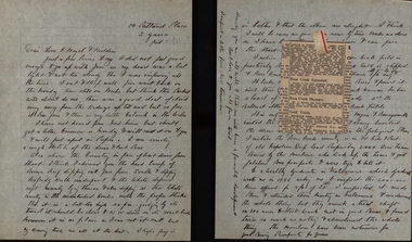
... Sand...G M of A...Gold Mines of Australia...Liz the Car...Geoff Squire...Lode...Cameron and Sutherland...Lancaster...Harman...Hayes Timber...T. Hood...Alan Squire...Catarrh...Kidney Disease...Stomach Issues...Ethel...Measles...Scarlet Fever...Ross Creek Field...J. Bourke...J. Cock...Ross Creek Gold Mining...Hayes Illness Poppet Carburetor Shaft Balance Weight Pearson Pulleys Syndicate Goon Suction Lease Reports Estimates Flat Fields Reef Trucks Pipeclay Sandstone Suction Pipe Valves Honeycomb Rock Mr Kermode Yarrowee Ballarat Reef Combs Cheques Yellow Slate Leigh River Dyke Quartz Ballarat Deep Leads Ballarat Deep Leads Extension Bore Reads Bedrock Cemented Sand G M of A Gold Mines of Australia Liz the Car Geoff Squire Lode Cameron and Sutherland Lancaster Harman Hayes Timber T. Hood Alan Squire Catarrh Kidney Disease Stomach Issues Ethel Measles Scarlet Fever Ross Creek Field J. Bourke J. Cock Ross Creek Gold Mining ...In 1905 Richard Squire was manager of the West Berry Consuls at Allendale, and developed an improved system of mine ventilation, which was supported in "The Age." He was successful in combating and remedying the gas and ventilation troubles of the Deep Mines of Creswick and Allendale Districts after all had failed. MINE MANAGERS’ ASSOCIATION. Ballarat Branch. ... Mr. R. B. Squire, manager of the West Berry Consuls, at Allendale, submitted a paper detailing what he had done tor the betterment of ventilation in the alluvial mines of Smeaton and Mary borough districts- Members gave Mr. Squire every credit for the results that he claimed to have affected; the adoption of his ideas had testified to their value to mine-owners. It was painted out, however, that for want of a thorough debate of the subject with experienced men the author had unwittingly included some general statements that required modifying in some points and extending in others, in justice to other workers among the earlier and the present-day managers of mines. It was decided to invite the author to meet a sub-committee on this subject!Various letters written by Richard Squire to his son Tom on the topic of their Mine in 1936 richard squire, tom squire, hazel squire, jack squire, jim squire, ned, mt mercer, basil, plant, skids, pump, c. hayes, illness, poppet, carburetor, shaft, balance weight, pearson, pulleys, syndicate, goon, suction, lease, reports, estimates, flat fields, reef, trucks, pipeclay, sandstone, suction pipe, valves, honeycomb rock, mr kermode, yarrowee, ballarat, reef combs, cheques, yellow slate, leigh river, dyke, quartz, ballarat deep leads, ballarat deep leads extension, bore, reads, bedrock, cemented sand, g m of a, gold mines of australia, liz the car, geoff squire, lode, cameron and sutherland, lancaster, harman, hayes timber, t. hood, alan squire, catarrh, kidney disease, stomach issues, ethel, measles, scarlet fever, ross creek field, j. bourke, j. cock, ross creek gold mining co., frank herman, hogan & banagwanath, hogan, banagwanath, napolean deap lead, hanlons, lillas, martin, jack hayes, diptheria, anticline, mr mcnichol, ronaldson, bob allan, jenkins, hunter, wilkinson, eyres brothers, g.gay & co, buninyong, llewellen, glenfine, the star mine of avoca fields, talbot alluvials, g.e. dickenson, guildford plateau, a.b.c. special supply store, jelbart, geological branch, shell coy, mr horsefields, lawaluk, almanac, trenery, barry, mining -
 Federation University Historical Collection
Letter, Letters written by Richard Squire to his son Tom Squire 1937
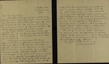
... Sand...G M of A...Gold Mines of Australia...Liz the Car...Geoff Squire...Lode...Cameron and Sutherland...Hayes Timber...Alan Squire...Ethel...Ross Creek Field...Ross Creek Gold Mining...Richard Squire Tom Squire Hazel Squire Jack Squire Jim Squire Ned Mt Mercer Plant Skids Pump Poppet Carburetor Shaft Balance Weight Pulleys Syndicate Suction Lease Reports Estimates Flat Fields Reef Trucks Pipeclay Sandstone Suction Pipe Valves Honeycomb Rock Yarrowee Ballarat Reef Combs Cheques Yellow Slate Leigh River Dyke Quartz Ballarat Deep Leads Ballarat Deep Leads Extension Bore Reads Bedrock Cemented Sand G M of A Gold Mines of Australia Liz the Car Geoff Squire Lode Cameron and Sutherland Hayes Timber Alan Squire Ethel Ross Creek Field Ross Creek Gold Mining Co. ...In 1905 Richard Squire was manager of the West Berry Consols at Allendale, and developed an improved system of mine ventilation, which was supported in "The Age."[4] He was successful in combating and remedying the gas and ventilation troubles of the Deep Mines of Creswick and Allendale Districts after all had failed. MINE MANAGERS’ ASSOCIATION. Ballarat Branch. ... Mr R. B. Squire, manager of the West Berry Consols, at Allendale, submitted a paper detailing what he had done tor the betterment of ventilation in the alluvial mines of Smeaton and Mary borough districts- Members gave Mr Squire every credit for the results that he claimed to have effected; the adoption of his ideas had testified to their value to mine-owners. It was painted out, however, that for want of a thorough debate of the subject with experienced men the author had unwittingly included some general statements that required modifying in some points and extending in others, in justice to other workers among the earlier and the present day managers of mines. It was decided to invite the author to meet a sub-committee on this subject!A variety of Letters written by Richard Squire to his son Tom Squire about the goings on at Mt Mercer Mine 1937richard squire, tom squire, hazel squire, jack squire, jim squire, ned, mt mercer, plant, skids, pump, poppet, carburetor, shaft, balance weight, pulleys, syndicate, suction, lease, reports, estimates, flat fields, reef, trucks, pipeclay, sandstone, suction pipe, valves, honeycomb rock, yarrowee, ballarat, reef combs, cheques, yellow slate, leigh river, dyke, quartz, ballarat deep leads, ballarat deep leads extension, bore, reads, bedrock, cemented sand, g m of a, gold mines of australia, liz the car, geoff squire, lode, cameron and sutherland, hayes timber, alan squire, ethel, ross creek field, ross creek gold mining co., frank herman, lillas, jack hayes, eyres brothers, g.gay & co, buninyong, glenfine, the star mine of avoca fields, talbot alluvials, guildford plateau, a.b.c. special supply store, geological branch, shell coy, lawaluk, almanac, mcbinny, bingley's paddock, cargaire valley and lead, stand and deliver demands, sheehan's, smeaton hotel, john charleson, aleck charleson, ted brown, billy jordan, mr banks, ballarat main lead, binney, goon, illabrook, mrs trenery, bre, max, june, mary, len, barry, hunter, herman, martin, aunt annie, bella, pitfield coy, mcnaughtons, donaldson, dereel, hogan, the bay leads, avoca field, ballarat alluvials, neil cameron, haddon field, courier, tom cotton, llewellen, stanley hunter, mr leonard, tom mitchell, school of mines, bryant, a.c. connely, dodson, constable mcmullins, adam ronaldson, bewick mining & co., reginald murray, r.c. selwyn, craig's hotel, broken hill syndicate, morrison's lead, wilkinson, j. hayes, mr nichol, burglary, baragwanath, wilkinson ross, creswick, seville, mr. ross, o'connor, c. mcgrath, alfred mica smith, henderson ross, angus kelly, a. r. dodson, duke of wellington plant, the moorabool lead, williams, paralysis, woodlock, squire, whipp, joe williams, peacock, moran, buchanan, hoare, bree kutchel, kohinoor band and alluvian, star of the east, bonshaw, epidemic, polio, mining -
 Federation University Historical Collection
Letter, Letters written by Richard Squire to his son Tom Squire 1938
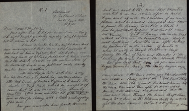
... Sand...G M of A...Gold Mines of Australia...Liz the Car...Geoff Squire...Lode...Hayes Timber...Ethel...Ross Creek Field...Ross Creek Gold Mining...It was decided to invite the author to meet a sub-committee on this subject Richard Squire Tom Squire Hazel Squire Jack Squire Jim Squire Ned Mt Mercer Plant Skids Pump Poppet Carburetor Shaft Balance Weight Pulleys Syndicate Suction Lease Reports Estimates Flat Fields Reef Trucks Pipeclay Sandstone Suction Pipe Valves Honeycomb Rock Yarrowee Ballarat Reef Combs Cheques Yellow Slate Leigh River Dyke Quartz Ballarat Deep Leads Ballarat Deep Leads Extension Bore Reads Bedrock Cemented Sand G M of A Gold Mines of Australia Liz the Car Geoff Squire Lode Hayes Timber Ethel Ross Creek Field Ross Creek Gold Mining Co. ...In 1905 Richard Squire was manager of the West Berry Consols at Allendale, and developed an improved system of mine ventilation, which was supported in "The Age."[4] He was successful in combating and remedying the gas and ventilation troubles of the Deep Mines of Creswick and Allendale Districts after all had failed. MINE MANAGERS’ ASSOCIATION. Ballarat Branch. ... Mr R. B. Squire, manager of the West Berry Consols, at Allendale, submitted a paper detailing what he had done tor the betterment of ventilation in the alluvial mines of Smeaton and Mary borough districts- Members gave Mr Squire every credit for the results that he claimed to have effected; the adoption of his ideas had testified to their value to mine-owners. It was painted out, however, that for want of a thorough debate of the subject with experienced men the author had unwittingly included some general statements that required modifying in some points and extending in others, in justice to other workers among the earlier and the present day managers of mines. It was decided to invite the author to meet a sub-committee on this subjectHandwritten letters written by Richard Squire to his son Tom Squire 1938 on lined paperrichard squire, tom squire, hazel squire, jack squire, jim squire, ned, mt mercer, plant, skids, pump, poppet, carburetor, shaft, balance weight, pulleys, syndicate, suction, lease, reports, estimates, flat fields, reef, trucks, pipeclay, sandstone, suction pipe, valves, honeycomb rock, yarrowee, ballarat, reef combs, cheques, yellow slate, leigh river, dyke, quartz, ballarat deep leads, ballarat deep leads extension, bore, reads, bedrock, cemented sand, g m of a, gold mines of australia, liz the car, geoff squire, lode, hayes timber, ethel, ross creek field, ross creek gold mining co., frank herman, lillas, jack hayes, eyres brothers, g.gay & co, buninyong, glenfine, the star mine of avoca fields, talbot alluvials, guildford plateau, a.b.c. special supply store, geological branch, shell coy, lawaluk, almanac, mcbinny, bingley's paddock, cargaire valley and lead, stand and deliver demands, sheehan's, smeaton hotel, john charleson, ballarat main lead, goon, dereel, the bay leads, avoca field, ballarat alluvials, haddon field, courier, school of mines, bewick mining & co., broken hill syndicate, morrison's lead, baragwanath, creswick, duke of wellington plant, the moorabool lead, kohinoor band and alluvian, star of the east, bonshaw, epidemic, polio, k.w. steedman, mr newman, allendale mines, professor mica smith, alfred mica smith, mr hodge, w. taylor, mcpherson's reward coy, mr mitchell, billy thomas, john bull, albert, nina, stanley hunter, frederick the great, ross creek south, bislolo, brilolo, birlolo, ballarat east coy, maxwells, reginald murray, bob allan, vendetta, john lynch, dodson, mnster of mines, e.j. hogan, jonah ward, mcnaughton's paddock, bellesby, alec peacock, jenkins, h.c. jenkins, conspiracy, argus, mr ellerby, dr lawrence, occulist, mining -
 Bendigo Historical Society Inc.
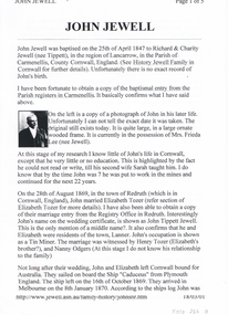
Document - LONG GULLY HISTORY GROUP COLLECTION: JOHN JEWELL
... Mining Managers Association... Star of Eaglehawk I.O.O.F.... Hopetoun Band... Carlisle Mine Cricket Club ... Bell's Reef Co Maldon... Long Gully Fire Brigade...DR Simmonds... Lanner... White Hills Cemetery... R Bennetts... J Cox... W Arkinstall... W Steen... G Cox... T Delchuray... Mr A Hicks MLC... Mr W Verece... Messrs Norris and Son... Passby Mine... Ah Poo & Co (workers of the sand...Mining Managers Association Star of Eaglehawk I.O.O.F. Hopetoun Band Carlisle Mine Cricket Club Bell's Reef Co Maldon Long Gully Fire Brigade DR Simmonds Lanner White Hills Cemetery R Bennetts J Cox W Arkinstall W Steen G Cox T Delchuray Mr A Hicks MLC Mr W Verece Messrs Norris and Son Passby Mine Ah Poo & Co (workers of the sand) Mr W Farmer Five typed pages outlining the life of John Jewell from his birth in Cornwall to his marriages, immigration to Australia and his living in Ballarat, North Queensland and then to Bendigo where he worked at the Kentish Mine and was later the Manager. ...Five typed pages outlining the life of John Jewell from his birth in Cornwall to his marriages, immigration to Australia and his living in Ballarat, North Queensland and then to Bendigo where he worked at the Kentish Mine and was later the Manager. He also managed the Carlisle and Unity Batteries, was involved in a number of organisations and lent large sums of money to the Methodist Church in McIntyre Street Bendigo. There is a photo of John in his later life, one of his houses, John surrounded by 7 of his Grandchildren. and his headstone.bendigo, history, long gully history group, the long gully history group - john jewell, richard jewell, charity jewell (nee tippett), history of jewell family in cornwall, mrs frieda lee (nee jewell), sarah jewell, elizabeth tozer, john tippett jewell, henry tozer, nanny odgers, 'cadeueus', william john jewell, elizabeth jewell, john jewell, richard james jewell, kentish mine, george henry jewell, sarah ann clark, frederick albert victor jewell, william leslie norman jewell, mr j b watson, carlisle company, john jewell junior, carlisle battery, unity battery, the bendigonian 6/7/1909, long gully imperial football club, mining managers association, star of eaglehawk i.o.o.f., hopetoun band, carlisle mine cricket club , bell's reef co maldon, long gully fire brigade, dr simmonds, lanner, white hills cemetery, r bennetts, j cox, w arkinstall, w steen, g cox, t delchuray, mr a hicks mlc, mr w verece, messrs norris and son, passby mine, ah poo & co (workers of the sand), mr w farmer -
 Bendigo Historical Society Inc.
Photograph - PHOTOGRAPH OF DEVONSHIRE DUMPS 1954
... ...Mining equipment...Devonshire Sand...History House 11 Mackenzie Street Bendigo goldfields GOLD MINES Mining equipment Devonshire Sand Dump Black and white photo attached to board. ...Black and white photo attached to board. Image shows Devonshire sand dumps, man standing in centre holding a large hose, squirting water at the surface of the dump. High walls of dump behind. On back " Devonshire Dumps Sluicing 1951"gold mines, mining equipment, devonshire sand dump -
 Bendigo Historical Society Inc.
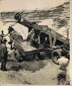
Photograph - PHOTOGRAPH OF DEVONSHIRE SANDS DUMP
... ...Mining equipment...Devonshire Sand...History House 11 Mackenzie Street Bendigo goldfields GOLD MINES Mining equipment Devonshire Sand Dump Black and white photograph on board. ...Black and white photograph on board. Image shows machine with conveyor belt emptying sand into a trailer harnessed to a draft horse. Machine has plate on side 'Pat No. 3281' A man is standing holding the draft horse bridle with other hand on shaft of trailer. Man standing (LH side) observing the proceedings is wearing a suit and hat. Man standing with back to camera in bottom RH corner. In background, layered sand. Written on back in pencil 'Devonshire Sands'gold mines, mining equipment, devonshire sand dump -
 Bendigo Historical Society Inc.
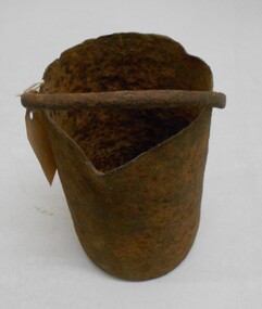
Tool - MERCURY BUCKET
... sand slurry was splashed by the falling stamps from the box through fine mesh screens and onto inclined wooden tables below the mortar box (figure 2). The tables were covered with copper sheets or plates coated with mercury... which caught and amalgamated with a portion of the gold. The grey putty-like amalgam was periodically scraped off the sheets and retorted in a furnace to collect the gold and recover the mercury for reuse. Mercury was inevitably lost from the plates... while poor maintenance resulted in further losses of gold and mercury in the tailings. Mercury use and loss from gold mining...sand slurry was splashed by the falling stamps from the box through fine mesh screens and onto inclined wooden tables below the mortar box (figure 2). The tables were covered with copper sheets or plates coated with mercury which caught and amalgamated with a portion of the gold. The grey putty-like amalgam was periodically scraped off the sheets and retorted in a furnace to collect the gold and recover the mercury for reuse. Mercury was inevitably lost from the plates while poor maintenance resulted in further losses of gold and mercury in the tailings. Mercury use and loss from gold mining ...Cast iron mercury bucket, used to hold mercury, potentially in the process of recovering minute pieces of gold mixed in soil and sediments. See research page for description of one process of using mercury to extract gold.gold mines, mining equipment, mercury bucket, miners used mercury in a number of ways to amalgamate gold, with each mill or battery operator having their preferred method depending on the nature of the ore. by the late 1850s the most common way of crushing goldbearing quartz ores or consolidated alluvial cements was in a stamp battery. the battery featured heavy iron stamp heads held in a frame, with each head often weighing up to 500 pounds (226 kg) or more (see msv 1880, page 45) (birrell 2005). stamp heads were lifted and dropped by a rotating overhead cam shaft driven by a steam engine or water wheel. ore was fed into a large cast-iron battery box, mixed with a steady stream of water, and pulverised by the stamp heads. in some batteries, mercury was placed in the base of the boxes to amalgamate with freed gold. the violent agitation of the mercury in the mortar box, however, could cause the mercury to break into myriad tiny globules that were carried away by the water with the tailings, thus losing a certain amount of gold in the process (thompson 1867; ritchie & hooker 1997). the water and sand slurry was splashed by the falling stamps from the box through fine mesh screens and onto inclined wooden tables below the mortar box (figure 2). the tables were covered with copper sheets or plates coated with mercury, which caught and amalgamated with a portion of the gold. the grey putty-like amalgam was periodically scraped off the sheets and retorted in a furnace to collect the gold and recover the mercury for reuse. mercury was inevitably lost from the plates, while poor maintenance resulted in further losses of gold and mercury in the tailings. mercury use and loss from gold mining in 19th century victoria. peter davies1, susan lawrence, and jodi turnbull, department of archaeology and history, la trobe university. -
 Bendigo Historical Society Inc.
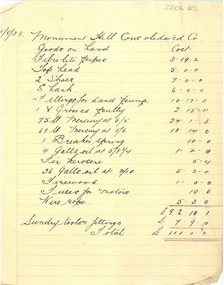
Document - MCCOLL, RANKIN AND STANISTREET COLLECTION: LIST OF PAYMENTS MONUMENT HILL CONSOLIDATED CO
... History House 11 Mackenzie Street Bendigo goldfields BUSINESS Mining Monument Hill Consolidated Company A4 sheet dated 31/8/39, handwritten list of payments - kerosene, mercury, firewood, fuses for motors, wire rope, fittings for sand pump etc. ...A4 sheet dated 31/8/39, handwritten list of payments - kerosene, mercury, firewood, fuses for motors, wire rope, fittings for sand pump etc. On top of paper ' Monument Hill Consolidated Co.'business, mining, monument hill consolidated company -
 The Beechworth Burke Museum
Geological specimen - Fossil Leaves
... sand, or volcanic ash. Often, it gets detached cleanly from stems along a special layer of weak cells, then twigs, and, less commonly, cones of conifers and fruits and seeds of flowering plants. Over time, the leaves or pieces of leaves get buried by more sediments and eventually gets 'lithified' or hardened into a rock. Erosions and mining...sand, or volcanic ash. Often, it gets detached cleanly from stems along a special layer of weak cells, then twigs, and, less commonly, cones of conifers and fruits and seeds of flowering plants. Over time, the leaves or pieces of leaves get buried by more sediments and eventually gets 'lithified' or hardened into a rock. Erosions and mining ...A fossil refers to any remains or traces of past life that are preserved in the rock. It could be remains of plants or animals. Fossil leaves are commonly found on different types of rocks. These fossils can go as far back as the Triassic Age just like the series of fossil plants collected at Denmark Hill, Ipswich in Queensland. Fossils leaves are formed when dead plants get buried by sediments like mud, sand, or volcanic ash. Often, it gets detached cleanly from stems along a special layer of weak cells, then twigs, and, less commonly, cones of conifers and fruits and seeds of flowering plants. Over time, the leaves or pieces of leaves get buried by more sediments and eventually gets 'lithified' or hardened into a rock. Erosions and mining can cause the rocks to break and reveal the fossils buried in it. Fossilisation frequently takes place at sites in the lowlands where deposits of clay, silt, sand are found. This is usually due to weathering and erosion of rocks. Fossil leaves can provide information about ancient Australia's way of living. It contributes to Victorian biodiversity records and its botanical collections. It also contributes information on the geographical profile of Victoria as fossilisation usually occur at estuaries and deltas of rivers, river flood plains, ponds and lakes. This specimen is part of a larger collection of geological and mineral specimens collected from around Australia (and some parts of the world) and donated to the Burke Museum between 1868-1880. A large percentage of these specimens were collected in Victoria as part of the Geological Survey of Victoria that begun in 1852 (in response to the Gold Rush) to study and map the geology of Victoria. Collecting geological specimens was an important part of mapping and understanding the scientific makeup of the earth. Many of these specimens were sent to research and collecting organisations across Australia, including the Burke Museum, to educate and encourage further study.Piece of light brown rock with fossilised leaves in shades of golden yellow and brown.Existing label: Fossil Leaves / Locality unknown / might be worth checking if this is Glossopteris, a Permian age plant. / C. William 16/4/21 geological specimen, geology, geology collection, burke museum, beechworth, fossil leaves, fossilization, 1868 geological survey of victoria, lithified, rocks, fossilised leaf, rock, fossils, leaves -
 The Beechworth Burke Museum
Photograph, c1900
... sand. Tunnel boring machines are used as an alternative to drilling and blasting (D&B) methods in rock and conventional "hand mining" in soil. ...sand. Tunnel boring machines are used as an alternative to drilling and blasting (D&B) methods in rock and conventional "hand mining" in soil. ...A black and white photograph depicting seven men and four women surrounded by tunnel boring machinery. A tunnel boring machine (TBM), also known as a "mole", is a machine used to excavate tunnels with a circular cross section through a variety of soil and rock strata. They may also be used for microtunneling. They can be designed to bore through anything from hard rock to sand. Tunnel boring machines are used as an alternative to drilling and blasting (D&B) methods in rock and conventional "hand mining" in soil. TBMs have the advantages of limiting the disturbance to the surrounding ground and producing a smooth tunnel wall. This significantly reduces the cost of lining the tunnel, and makes them suitable to use in heavily urbanised areas. The major disadvantage is the upfront cost. TBMs are expensive to construct, and can be difficult to transport. The longer the tunnel, the less the relative cost of tunnel boring machines versus drill and blast methods. This is because tunneling with TBMs is much more efficient and results in shortened completion times, assuming they operate successfully. Drilling and blasting however remains the preferred method when working through heavily fractured and sheared rock layers.This photograph is significant as it shows the machinery used and attire worn by men and women during the gold rush era. Black and white rectangular photograph printed on photographic paperburke museum, mining, beechworth, boring machinery, excavate, gold, gold fields, gold rush, miners -
 The Beechworth Burke Museum
Photograph
... Open cut sluicing involved the use of high-powered hoses which used the centrifugal sand pump system (known as hydraulic sluicing) which broke down the soil which was then processed for quartz, gold and other materials. After the resources where drained, Wallace reaped the benefits of his mining business. ...Open cut sluicing involved the use of high-powered hoses which used the centrifugal sand pump system (known as hydraulic sluicing) which broke down the soil which was then processed for quartz, gold and other materials. After the resources where drained, Wallace reaped the benefits of his mining business. ...This photograph dating between the 1850s and early 1900s depicts an open cut sluicing site located in Allan's Flat looking upon the open cut from Staghorn Flat Number 1. Sluicing was undertaken in the area from 1850 to 1904. The image depicts a location mined by Yackandandah Sluicing Co. It portrays and open space with pipes laying on the ground and connected to pipes leaving the barge. These pipes were used to wash and seperate the qaurtz. There are two small buildings on high ground over looking the barge. Yackandandah Sluicing Co. was created by J.A. Wallace in the 1880s. The Yackandandah Sluicing Co. operated from the mid-1880s to the early 1900s, when resources eventually ran out. Open cut sluicing involved the use of high-powered hoses which used the centrifugal sand pump system (known as hydraulic sluicing) which broke down the soil which was then processed for quartz, gold and other materials. After the resources where drained, Wallace reaped the benefits of his mining business. Allan's Flat is located on the Yackandandah Creek, and is 10km north-east of Yackandandah and 20km south of Wodonga in Victoria's regional north-east. Allan's Flat was initially used to mine gold through alluvial methods, however that came to an end with little results. The mining business was then revived by J.A. Wallace with the introduction of hydraulic sluicing.The search for gold is ingrained into the history of Victoria and therefore, images like this one which portray an open cut sluicing site can reveal important information for society and technology for the date when the photograph was taken. This image is of important historical significance for its ability to convey information about sluicing and the methods used to find gold and other minerals in the lat 19th Century. It also shows a location where sluicing was undertook which provides insight into the impact of sluicing on the environment at a time when it was done. This image is important for current research into the history of Allan's Flat, a small regional location near Yackandandah in Victoria's North East. Therefore, this image has the capacity to be beneficial for research into society and the motivations of those living and working in this region during this period and therefore, has social significance. The Beechworth Burke Museum has additional images relating to gold sluicing and Allan's Flat which can be analysed and studied alongside images like this one.Sepia coloured retangular photograph printed on gloss photographic paper mounted on board.Revers: Sluicing at Allan's Fortallan's flat, north east gold, sluicing, gold sluicing, hydraulic sluicing, mining, gold and quartz mine, beechworth, burke museum, yackandandah -
 The Beechworth Burke Museum
Photograph, 1910 - 1911
... sand pump system (known as hydraulic sluicing) which broke down the soil which was then processed for gold and other precious metals. From 1914, four years after this image was captured, the company reformed to Cocks Pioneer Gold and Tin Mines NL (previously it was known as Cocks Pioneer Sluicing Co) and undertook large-scale sluicing operations until 1929 and then 1934-1941. The Cocks Pioneer was an extremely successful mining...sand pump system (known as hydraulic sluicing) which broke down the soil which was then processed for gold and other precious metals. From 1914, four years after this image was captured, the company reformed to Cocks Pioneer Gold and Tin Mines NL (previously it was known as Cocks Pioneer Sluicing Co) and undertook large-scale sluicing operations until 1929 and then 1934-1941. The Cocks Pioneer was an extremely successful mining ...This photograph depicts Cock's Pioneer G & T Sluicing site No. 4 in El Dorado. Looking eastwards, the photo captures a wooden and tin building with various mining equipment strewn in the foreground. Underneath the verandah, figures can be seen. These are believed to be a Mr. Hollister (left), Mrs. Breustedt (4th from left), children Min and Chris Breustedt, and Kate Timmons holding a girl's hand. The Cocks Pioneer Gold and Tin Mines N.L was one of El Dorado's two largest open-cut sluicing mines of the 20th Century. The other was named the Cocks El Dorado Gold Dredging Company. The Cocks Pioneer Mines operated from 1901 until 1941 and found a total of 117,378 ounces of Gold and 1,673 tones of tin concentrates over these years. The Cocks company was formed in 1898 and operated until 1941. Open cut sluicing involved the use of high-powered hoses which used the centrifugal sand pump system (known as hydraulic sluicing) which broke down the soil which was then processed for gold and other precious metals. From 1914, four years after this image was captured, the company reformed to Cocks Pioneer Gold and Tin Mines NL (previously it was known as Cocks Pioneer Sluicing Co) and undertook large-scale sluicing operations until 1929 and then 1934-1941. The Cocks Pioneer was an extremely successful mining company during the 20th century. In the Annual Report of the Secretary for Mines for the year 1915, the Cocks Pioneer was the largest producer of gold and tin collecting 5,535 ozs. of gold and £7,500 of tin. Twenty years later in 1935, Cocks Pioneer was still one of the most profitable mines in Victoria, ranking as the second-highest dividend paying mine. The company produced a total of 3,650 kg of gold. El Dorado is located on Reedy Creek and is surrounded by forested country to the north and east. It is 20 km east of Wangaratta in Victoria's regional northeast. John Cock was the son of a Cornish miner who arrived in El Dorado in 1858. Cock founded his gold and tin mining company which ran successfully for many years in the El Dorado region. It was an open-cut sluicing company because of the abandonment of underground mining after this was deemed too dangerous. In 1935 Cock's El Dorado Company commissioned the floating dredge which is still visible in El Dorado today. The dredge was built by the Thompson engineering works, Castlemaine, and weighed over 2,000 tones and today has a place on the Victorian Registers of historic buildings. Interestingly, the name El Dorado does not derive from the gold in the region, but from the Barambogie pastoral run completed by William Baker in 1840-1841. Gold was discovered in El Dorado in 1854 but the gold was too deep for individual prospectors to find, it required the use of heavy machinery.The search for gold is ingrained into the history of Victoria and therefore, images like this one which portray an open cut sluicing site can reveal important information for society and technology for the date when the photograph was taken. This image is of important historical significance for its ability to convey information about sluicing and the methods used to find gold in 1910. It also shows a location where sluicing was undertook which provides insight into the impact of sluicing on the environment at a time when it was done. This image is important for current research into the history of El Dorado, a small regional location near Wangaratta in Victoria's North East. Therefore, this image has the capacity to be beneficial for research into society and the motivations of those living and working in this region during this period and therefore, has social significance. The Beechworth Burke Museum has additional images relating to gold sluicing and El Dorado which can be analysed and studied alongside images like this one.A black and white copy of a sepia coloured rectangular photograph printed on matte photographic paper mounted on boardObverse: COCKS PIONEER G + T SL CO, N.L. / 1910 - 11 / NO 4 SITE LOOKING EAST / 4 Reverse: 1997.2508 / AUG 29 1909cocks pioneer gold and tin sluicing company, el dorado, mining, sluicing, hydraulic mining, hollister, breustedt, timmons, gold, tin, gold rush, victoria -
 Bendigo Historical Society Inc.
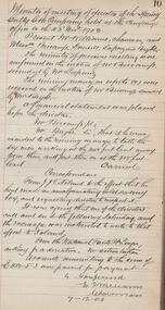
Administrative record - Spring Gully Gold Mining Co. Fryerstown, Minute Book1903 - 1915, 1924 - 1929
... sand. 2.Page one hundred and fifty five: handwritten letter (copy) from A. Schonfelder re shaft work on the mine and mention of tributors 3. Affixed to inside cover: letter from the 'United Shire of Mount Alexander' April 15th. 1907, regarding the reconstruction of the Vaughan bridge over the Loddon River. 'the benefit that the mines in your district derive from the bridge being open for wood waggons and this being the main traffic and this being the principal cause of the bridges present condition'. 4. Prospectus of the Spring Gully Mining...sand. 2.Page one hundred and fifty five: handwritten letter (copy) from A. Schonfelder re shaft work on the mine and mention of tributors 3. Affixed to inside cover: letter from the 'United Shire of Mount Alexander' April 15th. 1907, regarding the reconstruction of the Vaughan bridge over the Loddon River. 'the benefit that the mines in your district derive from the bridge being open for wood waggons and this being the main traffic and this being the principal cause of the bridges present condition'. 4. Prospectus of the Spring Gully Mining ...The Spring Gully Gold Mining property consists of Gold Mining Lease No. 2986, Castlemaine, of about 21 acres situated on the Emu Reef, in Spring Gully Fryers. There are two shafts, distant about 300 feet from each other. From one of them large quantities of gold were obtained in former years by previous companies. ( Prospectus of the Spring Gully Mining CompanyMaroon hard cover book, brown leather binding on spine and corners, three hundred and eighty pages. Written on spine of book in gold leaf : 'Minute Book'. Handwritten minute entries from 14th September 1903 to 30th August 1915. Affixed to first page, newspaper clipping from the 'Herald' 13/9/05, with information about the Spring Gully Mine Fryerstown. Page eighty-one has two quotes affixed from 'The Yarraville Chlorination and Ore Reduction Works' High Street Yarraville, July 1905, for works associated with pyrites and blanket sand. Page nine, a handwritten letter affixed to minutes, applying for a block of land 250 feet north of main shaft. Signed by J.S. Potter, H. Hancock, G Murray and T. Tumney. 1.Page one hundred and one: three quotes from 'Edwards' Metallurgical Works' Specimen Hill, Bendigo for pyrites and blanket sand. 2.Page one hundred and fifty five: handwritten letter (copy) from A. Schonfelder re shaft work on the mine and mention of tributors 3. Affixed to inside cover: letter from the 'United Shire of Mount Alexander' April 15th. 1907, regarding the reconstruction of the Vaughan bridge over the Loddon River. 'the benefit that the mines in your district derive from the bridge being open for wood waggons and this being the main traffic and this being the principal cause of the bridges present condition'. 4. Prospectus of the Spring Gully Mining Company, Spring Gull, Fryerstown, two page folded document enclosed inside back cover of book. Prospectus incomplete. (10746.93a) 5. Carbon copy of letter to D.E. Williams Esq, Castlemaine from GlenAthol, Casewick Road, London, January 25th, 1907 regarding two gentlemen who were 'called upon to carry the 'Spring Gullys' through - Mr. H. 'is making a determined effort to bring the matter to a successful issue' Letter signed by George Allan. (10746.93b. 6. Carbon copy of letter from E. Williams, London re proposed new company to acquire the properties of Spring G.M. Coy, Spring Gully G.M. Coy. No. 1, Sth Spring Gully G.M. Coy, Sth Spring Gully G.M. Coy Extended (10746.93c) 7. Handwritten letter to the Chairman and Directors of the Spring Gully G.M. Co. re the appointment of 'Mr. Samuel Morse Battery Manager at once, or accept my resignation as Mining Manager, for we can't agree any longer' Signed by A. Schonfelder. 8. Notice of extraordinary meeting of shareholders in Spring Gully Gold Mining Company No Liability, 22nd November 1906 at Beehive Chambers, Bendigo. Signed W.G. Blackham (Blackham & Garvin) Manager of the Company. (10746.93e) The Minute Book is part of the Margaret Roberts Collection of mining documents.bendigo, margaret roberts, , goldmining, castlemaine, spring gully gold mine, fryertown -
 Bendigo Historical Society Inc.
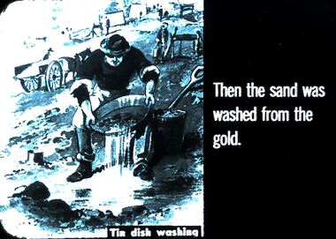
Slide - DIGGERS & MINING. THE GOLD ERA, c1850s
... Diggers & mining. The gold era. Then the sand was washed from the gold. ...History House 11 Mackenzie Street Bendigo goldfields BHS Collection EDUCATION Tertiary goldfields hanimount Diggers & mining. The gold era. Then the sand was washed from the gold. ...BHS CollectionDiggers & mining. The gold era. Then the sand was washed from the gold. Slide shows miner tin dish washing. Markings 17 994.031 GOL:5. Used as a teaching aid.hanimounteducation, tertiary, goldfields -
 Bendigo Historical Society Inc.
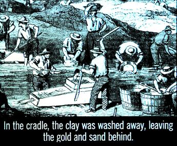
Slide - DIGGERS & MINING. THE GOLD ERA, c1850s
... mining. The gold era. In the cradle, the clay was washed away, leaving the gold and sand behind. ...mining. The gold era. In the cradle, the clay was washed away, leaving the gold and sand behind. ...BHS CollectionDiggers & mining. The gold era. In the cradle, the clay was washed away, leaving the gold and sand behind. Slide shows diggers using cradles and pans. Markings 16 994.031 GOL:5. Used as a teaching aid.hanimounteducation, tertiary, goldfields -
 Bendigo Historical Society Inc.
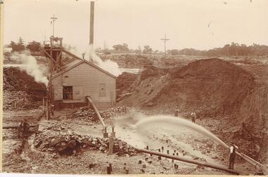
Photograph - AUSTIN COLLECTION: MINE SITE, SLUICING
... Large pile of sand or mullock on RH side. Mining dam in background, barely visible. ...History House 11 Mackenzie Street Bendigo goldfields BHS Collection BENDIGO Mining mine site Black and white photo: image shows mine site, chimney in background, corrugated iron shed in middleground, man operating sluice on bottom RH side. Men inside engine house looking on and two beside sluicing operation RH side. Large pile of sand ...BHS CollectionBlack and white photo: image shows mine site, chimney in background, corrugated iron shed in middleground, man operating sluice on bottom RH side. Men inside engine house looking on and two beside sluicing operation RH side. Large pile of sand or mullock on RH side. Mining dam in background, barely visible. Unidentified mine.bendigo, mining, mine site -
 Bendigo Historical Society Inc.
Newspaper - JENNY FOLEY COLLECTION: SAND SHOVELLERS
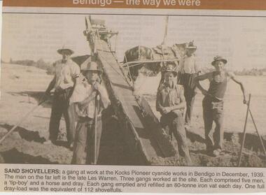
... mining interests. NEWSPAPER Bendigo advertiser the way we were Bendigo Advertiser ''The way we were'' from 2002. Sand ...The initial partnership in a quartz crushing plant between Henry Koch, Simon Albert and Charles Wallin was dissolved in 1860 with Koch becoming the sole owner. In 1866 the crushing plant consisted of a 50 hp engine and 48 stamping heads capable of crushing 600 tons of quartz per week. By 1902 there were 72 stamps and this was by far the largest crushing plant in the area, serving many quartz mines. Henry Koch (1800-1889) was a German sailor who signed off when his ship reached Melbourne in 1851. Having heard of the gold discovery he proceeded to Bendigo where he was initially employed in puddling in the Myers Flat area. He was soon employed and then made partner in a quartz crushing plant that he became sole owner of in 1860. He was also landlord at the British and American Hotel and the Silver Mines Hotel. HE also started the Perseverance United gold claim. He married Anna Maria Theresia Heinz in 1857. In 1872 he sold the crushing plant for 75,000 pounds and took his family back to Germany. He resumed his trade as a ship builder although he maintained many Bendigo mining interests.Bendigo Advertiser ''The way we were'' from 2002. Sand shovelers: a gang at work at the Kocks Pioneer cyanide works in Bendigo in December, 1939. The man on the far left is the late Les Warren. Three gangs worked at the site. Each comprised five men, a 'tip-boy' and a horse and dray. Each gang emptied and refilled an 80-tonne iron vat each day. One full dray-load was the equivalent of 112 shovelfuls. The clip is in a folder.newspaper, bendigo advertiser, the way we were -
 Bendigo Historical Society Inc.
Document - ALBERT RICHARDSON COLLECTION: CARLISLE UNITED MINE GARDEN GULLY LINE
... And the old Carlisle and North Garden only recently being unearthed beneath the Unity, 'Carlisle' sand heap.' Details about the mining plant, the main shaft, the winding engine air compressor, stone crusher, and engine house are given. ...And the old Carlisle and North Garden only recently being unearthed beneath the Unity, 'Carlisle' sand heap.' Details about the mining plant, the main shaft, the winding engine air compressor, stone crusher, and engine house are given. ...Eight page handwritten document with details of the Carlisle United Gold Mine at Long Gully. The lease was 76 acres, 660 yards on line of reef. The Kent shaft was the next mine north Havilah Road, Boldt Street's corner. 'The Carlisle United was formed by the amalgamation of ttte companies, the Old Carlisle, the North Garden and the Passby. These mines were situated on the west side of Bennett Street in about a length of a few hundred feet, with the Passby on the Casley Street corner. And the old Carlisle and North Garden only recently being unearthed beneath the Unity, 'Carlisle' sand heap.' Details about the mining plant, the main shaft, the winding engine air compressor, stone crusher, and engine house are given. The Kent shaft and steel poppet legs are described. Four early claims on the Carlisle United ground are listed: Morgan, Kirshner and Co., Boyd and Co. Claim, Shanks and Co's claim and Day and Co's claim.bendigo, mining, carlisle united -
 Bendigo Historical Society Inc.
Photograph - RALPH BIRRELL COLLECTION: TUNNEL BELOW THE CEMENT, WHITE HILLS
... History House 11 Mackenzie Street Bendigo goldfields BENDIGO Mining white hills Colour photograph: 'showing tunnels below the cement where the miners chipped the undersurface to get the gold The thickness of the cement can be seen' Loose sand and gravel above the cement has already been removed. ...Colour photograph: 'showing tunnels below the cement where the miners chipped the undersurface to get the gold The thickness of the cement can be seen' Loose sand and gravel above the cement has already been removed. Image shows layer of cement, tunnel visible on LH side, clay and gravel in front. (see Mosaic 4400.220 for detailed information regarding the White Hills, written by Dr. Ralph Birrell)bendigo, mining, white hills -
 Bendigo Historical Society Inc.
Photograph - RALPH BIRRELL COLLECTION: WHITE HILLS MINING SITE
... Loose sand and gravel above the cement has already been removed. Image shows mining tunnel visible going in under the cement. ...History House 11 Mackenzie Street Bendigo goldfields BENDIGO Mining white hills Colour photograph 'showing tunnels below the cement where the miners chipped the undersurface to get the gold The thickness of the cement can be seen'. Loose sand ...Colour photograph 'showing tunnels below the cement where the miners chipped the undersurface to get the gold The thickness of the cement can be seen'. Loose sand and gravel above the cement has already been removed. Image shows mining tunnel visible going in under the cement. White clay in foreground. (see Mosaic 4400.220 for detailed information regarding the White Hills, written by Dr. Ralph Birrell)bendigo, mining, white hills -
 Bendigo Historical Society Inc.
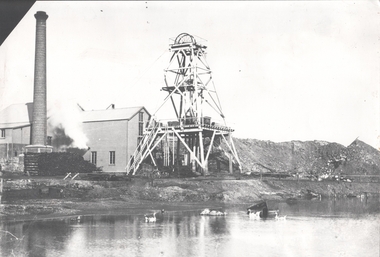
Photograph - FORTUNA COLLECTION: HUSTLERS AND ENERGETIC MINE
... History House 11 Mackenzie Street Bendigo goldfields BENDIGO Mining hercules and energetic mine Black and white photograph of mine site. Metal poppet head in centre, engine room buildings on LH side. Brick chimney extreme left. Large mullock/sand ...Black and white photograph of mine site. Metal poppet head in centre, engine room buildings on LH side. Brick chimney extreme left. Large mullock/sand heap on RH side. Mine dam in foreground, three geese floating in water. In front of poppet head, horse drawn wooden cartbendigo, mining, hercules and energetic mine -
 Bendigo Historical Society Inc.
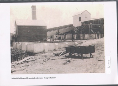
Photograph - Spargo's Pyrites, Specimen Hill
... Historic photo of mining at Specimen Hill. After crushing ore, the sand pyrites remaining could be treated to extract even finer gold. ...History House 11 Mackenzie Street Bendigo goldfields Historic photo of mining at Specimen Hill. After crushing ore, the sand pyrites remaining could be treated to extract even finer gold. ...Historic photo of mining at Specimen Hill. After crushing ore, the sand pyrites remaining could be treated to extract even finer gold. The sand was placed in large brick ovens to be roasted, which freed the sand of arsenic, sulphur etc, with the fumes containing these elements released into the atmosphere via a large chimney. Spargo's Pyrite Company operated from about 1870. It closed when there became a shortage of workers during WW1 and appears to have not restarted after the war. Black and white image, possibly copy. Weatherboard building on left hand side, elevated weatherboard building centre with chute descending to lower building. Possibly Spargo's Pyrites works, date unknownspargo's, pyrites -
 Bendigo Historical Society Inc.
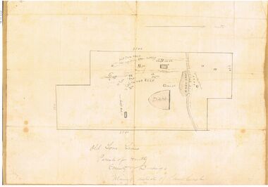
Map - OLD TOM MINE, WHIPSTICK
... sand heap, water race, 3 other shafts, 120ft., 90ft., and 500 ft. marked on map. Stamped on map '64.3.34' Written on bottom of map in handwriting ' Old Tom Lease, Parish of Huntly, County of Bendigo, Mining district of Sandhurst'...History House 11 Mackenzie Street Bendigo goldfields BENDIGO Mining old tom lease map 2 copies ( A4 and A3) of Old Tom lease. Map shows Old Tom Reef, old working open cutting, shaft 150 ft., Easter Reef, dam sand heap, water race, 3 other shafts, 120ft., 90ft., and 500 ft. marked on map. ...2 copies ( A4 and A3) of Old Tom lease. Map shows Old Tom Reef, old working open cutting, shaft 150 ft., Easter Reef, dam sand heap, water race, 3 other shafts, 120ft., 90ft., and 500 ft. marked on map. Stamped on map '64.3.34' Written on bottom of map in handwriting ' Old Tom Lease, Parish of Huntly, County of Bendigo, Mining district of Sandhurst'bendigo, mining, old tom lease map -
 Bendigo Historical Society Inc.
Document - NORTH DEBORAH GOLD MINING CO N. L. - ASSAY RESULTS FOR NORTH DEBORAH GOLD MINING CO N. L
... Mining Co N. L. Mr J J Stanistreet School of Mines Victor Leggo & Co Two handwritten pages, and typed copies of same, addressed to Mr J. J. Stanistreet, Commonwealth Bank Chambers, Bendigo. Notes mention the gross weight, moisture content and net-dry weight of Pyrites Lot no 68, Slimes or Strakes Lot No 67 and Blanket Sand Lot no 66. ...Two handwritten pages, and typed copies of same, addressed to Mr J. J. Stanistreet, Commonwealth Bank Chambers, Bendigo. Notes mention the gross weight, moisture content and net-dry weight of Pyrites Lot no 68, Slimes or Strakes Lot No 67 and Blanket Sand Lot no 66. Assay results are also mentioned. The share for Tributors is also tabled. Albert Richardson Collection. document, gold, north deborah gold mining co n. l., north deborah gold mining co n. l., assay results for north deborah gold mining co n. l., mr j j stanistreet, school of mines, victor leggo & co -
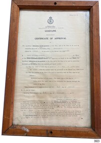 Flagstaff Hill Maritime Museum and Village
Document - Certificate of Approval, Load Line, 25-02-1970
... sand. The flat bottom was also to make the ship able to skim over reefs. Wagons could load and unload direct from her side. Her cargo included Guano, Barley, Wool, Horses, Cattle, Timber, Explosives, Potatoes, Shell Grit and Gypsum. After a variety of services, in late 1970 Reginald M was sold to the Mt. Lyell Mining...sand. The flat bottom was also to make the ship able to skim over reefs. Wagons could load and unload direct from her side. Her cargo included Guano, Barley, Wool, Horses, Cattle, Timber, Explosives, Potatoes, Shell Grit and Gypsum. After a variety of services, in late 1970 Reginald M was sold to the Mt. Lyell Mining ...This Certificate, Load-Line, gave approval for the vessel Reginald M to load cargo up to a certain line, marked by a disc attached to the ship and inspected by the South Australian Harbors Board. The vessel had a long and varied life of service. This Certificate relates to early 1970, before the ship was sold to the Lyall Mining and Rail Company. The Load Line on the Reginald M was carved on the ship, inside the hull and not removeable. The REGINALD M - The vessel “Reginald M” was a two-masted coastal ketch, owned and built by Mr. Jack (John) Murch of Birkenhead, Port of Adelaide, South Australia. Its construction took approximately 6 months and it was launched at Largs Bay in 1922. The Reginald M’s purpose was to serve the coastal trade of South Australia, to carry cargo cheaply and efficiently. It is believed that the keel was in fact hewn from two telegraph poles! Its builder frequented all the salvage yards for materials and fittings. Reginald M had a very shallow draft and a flat bottom that enabled it to come close to shore and to sit high and dry at low tide or to be beached on sand. The flat bottom was also to make the ship able to skim over reefs. Wagons could load and unload direct from her side. Her cargo included Guano, Barley, Wool, Horses, Cattle, Timber, Explosives, Potatoes, Shell Grit and Gypsum. After a variety of services, in late 1970 Reginald M was sold to the Mt. Lyell Mining and Railway Company and was used by them as a barge to carry explosives. In 1972 the Navy League of Strahan, Tasmania, purchased her for use by the Strahan Sea Cadet Unit to use at Macquarie Harbour and renamed her T.S. Macquarie. However this plan for use of Reginald M did not come to pass. In 1974 Mr. Andrew Rennie, of East Brighton, Melbourne, bought her for a similar purpose. , paying $5,000 and donating a ‘Cadet of the Year” trophy to the Sea Cadets. He sailed her from Strahan to Melbourne, planning to use her for pleasure sailing. Also in 1975 Reginald M was sold to Melbourne Ferry Company at auction. Later in 1975 the Reginald M was bought by Flagstaff Maritime Museum for $20,000 . She has been restored and is now one of the exhibits in the Village lagoon or lake. It was restored in 2006 using funds from a $4,000 government grant.This Certificate is significant because of its association with the last working days of REGINALD M. REGNIALD M was a coastal trading ketch from South Australia built in 1922. It was one of very few sailing coastal trading vessels still existing until 2016, and its flat bottom, single chine shape illustrated a very simple but robust method of construction, compared to other round bilged examples of trading vessels. The vessel is listed on the Australian Register of Historic Vessels (ARHV Number: HV000562.)Certificate, rectangular, behind glass in wooden frame. Certificate is an official printed form, some information is over-typed, other information is hand written and signed. Frame has a central hole in top and bottom. The Certificate relates to Load Level of the vessel Reginald M and refers to the exact placement of a disc within the vessel that indicates the maximum load in fresh water. . Issued to the vessel 'Reginald M', Official Number 137228. . Issued by the Sough Australian Harbors Board . Valid from 25-02-1970 to 31-01-1974. . Signed by Neil Cormack, 25th February 1970Certificate of Approval - Load Line for sailing vessel Reginald M, Official Number 137228. Logo of the South Australian Harbors Board. Issued by Department of Marine & Harbors, Port Adelaide, 25th February 1970. In force until 31st January 1974. Signed by Neil William Cormack, authorised officer for Department of Marine & Harbors. Typed onto form: "AUX [SAILING SIP]" "REGINALD M" "137228" "1968" " Neil William Cormack" "Department of Marine & Harbors" "1 [foot] 3 [inches below the] main [deck]" "31st JANUARY 74" "25th FEBRUARY 70" Signature: "Neil W Cormack"flagstaff hill, warrnambool, maritime village, maritime museum, flagstaff hill maritime museum & village, shipwreck coast, great ocean road, coastal trader, reginald m, ketch, john murch, ch murch, reg webb, carribie station, mt lyell copper company, melbourne ferry company, certificate of approval, load line, 137228, load line disc, 25-02-1970, neil w cormack, neil william cormack, south australian harbors board, department of marine and harbors, harbours