Showing 111 items matching "satellite"
-
 Sunshine and District Historical Society Incorporated
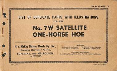
Manual - H.V. McKay Massey Harris - List of duplicate parts with illustrations for the No. 7 W Satellite One-Horse Hoe, SUNSHINE HARVESTER PRESS
... Small soft cover booklet stapled along the left spine listing duplicate parts with illustrations for the No. 7 W Satellite One-Horse Hoe...No. 7 W Satellite One-Horse Hoe...McKays Massey Ferguson Sunshine Harvester Works Farm Machinery No. 7 W Satellite One-Horse Hoe Small soft cover booklet stapled along the left spine listing duplicate parts with illustrations for the No. 7 W Satellite One-Horse Hoe Manual H.V. ...No. 7 W Satellite One-Horse Hoeh.v. mckays massey ferguson, sunshine harvester works, farm machinery -
 University of Melbourne, Burnley Campus Archives
Book - PhD Thesis, Satellite Based Yield - Water Use Relationships of PerennialHorticulture Crops, 2011
... Satellite Based Yield - Water Use Relationships of PerennialHorticulture Crops...University of Melbourne, Burnley Campus Archives 500 Yarra Boulevard Richmond melbourne PhD thesis Agricultural Science crops Typed and bound PhD Thesis Satellite Based Yield - Water Use Relationships of PerennialHorticulture Crops Book PhD Thesis ...phd thesis, agricultural science, crops -
Moorabbin Air Museum
Document (Item) - Airborne VHF Communications Transceiver And Mark I VHF Satellite Communications (SATCOM) System, Aeronautical Radio Inc
... Airborne VHF Communications Transceiver And Mark I VHF Satellite Communications (SATCOM) System, Aeronautical Radio Inc....Document Airborne VHF Communications Transceiver And Mark I VHF Satellite Communications (SATCOM) System, Aeronautical Radio Inc. ...Draft No.2 Of Project Paper No.546A -
 Eltham District Historical Society Inc
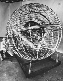
Photograph - Black and White Print, NASA, Tiros II, 1960
... ...Satellite...On reverse: Tiros II - Satellite mounted in cage to test magnetic stabilisation system....Eltham District Historical Society Inc 728 Main Rd Eltham melbourne Alan Gardiner Collection Space Industry 1960 Satellite Tiros II On reverse: Tiros II - Satellite mounted in cage to test magnetic stabilisation system. ...On reverse: Tiros II - Satellite mounted in cage to test magnetic stabilisation system.alan gardiner collection, space industry, 1960, satellite, tiros ii -
 Eltham District Historical Society Inc
Photograph - Black and White Print, NASA, Tiros II, 1960
... ...Satellite...On reverse: Tiros II - Mounted in machine to test satellite's stabilisation system. Lights test solar cells....Eltham District Historical Society Inc 728 Main Rd Eltham melbourne Alan Gardiner Collection Space Industry 1960 Satellite Tiros II On reverse: Tiros II - Mounted in machine to test satellite's stabilisation system. ...On reverse: Tiros II - Mounted in machine to test satellite's stabilisation system. Lights test solar cells.alan gardiner collection, space industry, 1960, satellite, tiros ii -
 Melton City Libraries
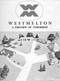
Document, West Melton: A preview of tomorrow, c.1969
... The development, called Westmelton Satellite City, was described as ‘a preview of tomorrow’.101 It was the first estate built in a ‘modern’ style, with curved streets, and dozens of culs de sac. ...A marketing brochure for the Westmelton Satellite City development...The development, called Westmelton Satellite City, was described as ‘a preview of tomorrow’.101 It was the first estate built in a ‘modern’ style, with curved streets, and dozens of culs de sac. ..."In April 1969, the first major residential development in Melton began with the release of 148 homes for purchase. This was the first stage of a staggered release of a planned 30,000 homes for 100,000 people by 1990. The development, called Westmelton Satellite City, was described as ‘a preview of tomorrow’.101 It was the first estate built in a ‘modern’ style, with curved streets, and dozens of culs de sac. Westmelton was also the first major development in Victoria to build all the supply lines to the houses – including electricity and telephone lines – underground. The six different home designs in Westmelton were ‘specially designed for the future’, and with allotments ten feet wider than regulations required, there was plenty of ‘space for gracious living’ and for a family swimming pool. The developers of this new estate were active in promoting Westmelton as a new community within the Shire of Melton. By 1971, the Westmelton City News reported that Ian McIntosh, General Manager of Westmelton, had given away $100,000 on behalf of the company ‘to aid community projects’. This included a $72,000 donation towards building a community centre in Westmelton, and $25,000 for the shire’s Olympic-sized swimming pool. Ian McIntosh and his family moved to Melton and Ian said he was ‘very much aware of the needs of [the] Westmelton community’. By the end of 1971, Westmelton was home to 100 new families. The modern residences were obviously an appealing drawcard, but so was the country feel that characterised Melton. Mrs C. Allen, described as a ‘housewife’, said she and her husband chose to move to Westmelton because of ‘the quality homes ... and we both love the clean, fresh, natural environment that surrounds us’. Similarly, Mr W. Coxhead, insurance consultant, moved to Westmelton because of the ‘clean, fresh country air’. Accountant Mr B. Swanton echoed their sentiments, describing Westmelton as ‘far enough away from the industrial pollution carried over Melbourne suburbs by prevailing westerly winds’. The new development attracted an increasing number of young, professional couples and families, representing the beginning of a significant shift from the predominantly rural and farming community of the district’s past. The Westmelton development had four different ‘neighbourhoods’ designed to cater to a variety of different lifestyle needs. Westmelton was the first to be established, followed by Brookfield, which offered ‘superb land in a rustic setting’. Brookfield Acres offered ‘wide open spaces with lots of room for a pool and even a tennis court’ on huge one-acre blocks, while Westlake was an innovative development with ‘different sized homesites’ and ‘lakeside living’.Westmelton was the first of many residential developments that would come to play a huge role in shaping the shire in the decades to follow".A marketing brochure for the Westmelton Satellite City developmentlocal significant events, council -
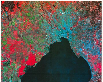 Queenscliffe Maritime Museum
Print - Melbourne by Satellite by Woman's Weekly c1986, Aerial photo of Port Phillip c1986, c1986
... Colour print insert from Woman's Weekly 1986, 'Melbourne by Satellite'....Print Melbourne by Satellite by Woman's Weekly c1986 ...Port PhillipAerial view of Port Phillip from 705km, 1986.Colour print insert from Woman's Weekly 1986, 'Melbourne by Satellite'.Reverse " Nil " -
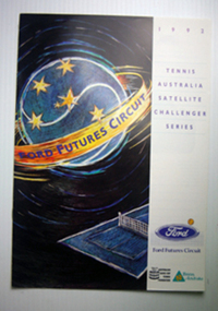 Tennis Australia
Tournament Programme
... Programme: Tennis Australia Satellite Challenger Series 1992 Materials: Paper, Ink...Tennis Australia Melbourne Park Olympic Boulevard Melbourne Park Melbourne melbourne Tennis Programme: Tennis Australia Satellite Challenger Series 1992 Materials: Paper, Ink Tournament Programme ...Programme: Tennis Australia Satellite Challenger Series 1992 Materials: Paper, Inktennis -
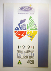 Tennis Australia
Tournament Programme
... Programme: Tennis Australia Satellite Challenger Series 1991 Materials: Paper, Ink...Tennis Australia Melbourne Park Olympic Boulevard Melbourne Park Melbourne melbourne Tennis Programme: Tennis Australia Satellite Challenger Series 1991 Materials: Paper, Ink Tournament Programme ...Programme: Tennis Australia Satellite Challenger Series 1991 Materials: Paper, Inktennis -
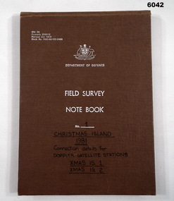 Bendigo Military Museum
Journal - Field Survey Notebook No1 Christmas Island 1981, SSGT JD Mobbs and CPL NF Kelly, Department of Defence, Field survey Notebook No1 Christmas Island 1981, 09.02.1981
... "Connection Details for Doppler Satellite Stations." "Xmas Is 1", "Xmas Is 2"...Kelly, CPL Royal Australian Survey Corps RASvy Fortuna Army Survey Regiment Army Svy Regt ASR "Connection Details for Doppler Satellite Stations." "Xmas Is 1", "Xmas Is 2" Cloth covered Cardboard, 100 Pages, Field Survey Notebook Department of Defence, Field survey Notebook No1 Christmas Island 1981 Journal Field Survey Notebook No1 Christmas Island 1981 SSGT JD Mobbs and CPL NF Kelly ...Notebook compiled by J.D. Mobbs, SSGT and N.F. Kelly, CPLCloth covered Cardboard, 100 Pages, Field Survey Notebook"Connection Details for Doppler Satellite Stations." "Xmas Is 1", "Xmas Is 2"royal australian survey corps, rasvy, fortuna, army survey regiment, army svy regt, asr -
 Sunshine and District Historical Society Incorporated
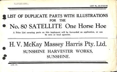
Manual - Sunshine Harvester Mckay Massey Harris - List of duplicate parts with illustrations for the No 80 Satellite One Horse Hoe, H.V. McKay Massey Harris Pty. Ltd
... Small booklet with no cover listing duplicate partw with illustrations for the No. 80 Satellite One Horse Hoe...Small booklet with no cover listing duplicate partw with illustrations for the No. 80 Satellite One Horse Hoe Manual Sunshine Harvester Mckay Massey Harris - List of duplicate parts with illustrations for the No 80 Satellite One Horse Hoe H.V. ...Ex Museum of Victoria - Lot 2, Box 2 of 3"G. Mulkearns" is type-written on the front page.h.v. mckays massey ferguson, sunshine harvester works, farm machinery -
 Sunshine and District Historical Society Incorporated
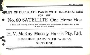
Manual - Sunshine Harvester McKay Massey Harris - List of duplicate parts with illustrations for the No. 80 Satellite One Horse Hoe, H.V. McKay Massey Harris Pty. Ltd
... Small booklet with no cover listing duplicate parts with illustrations for the No. 80 Satellite One Horse Hoe. See also Registration No. 1377...McKays Massey Ferguson Sunshine Harvester Works Farm Machinery Small booklet with no cover listing duplicate parts with illustrations for the No. 80 Satellite One Horse Hoe. See also Registration No. 1377 Manual Sunshine Harvester McKay Massey Harris - List of duplicate parts with illustrations for the No. 80 Satellite One Horse Hoe H.V. ...Ex Museum of Victoria - Lot, Box 2 of 3h.v. mckays massey ferguson, sunshine harvester works, farm machinery -
 Sunshine and District Historical Society Incorporated
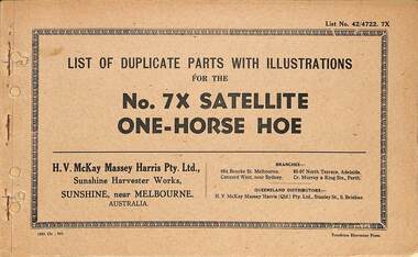
Manual - Sunshine Harvester Mckay Massey Harris - List of duplicate parts with illustrations for the No 7X Satellite One Horse Hoe, SUNSHINE HARVESTER PRESS
... Small soft cover booklet stapled along the left spine listing duplicate parts with illustrations for the No. 7X Satellite One-Horse Hoe...McKays Massey Ferguson Sunshine Harvester Works Farm Machinery Small soft cover booklet stapled along the left spine listing duplicate parts with illustrations for the No. 7X Satellite One-Horse Hoe Manual Sunshine Harvester Mckay Massey Harris - List of duplicate parts with illustrations for the No 7X Satellite One Horse Hoe SUNSHINE HARVESTER PRESS H.V. ...Ex Museum of Victoria - Lot 2, Box 2 of 3h.v. mckays massey ferguson, sunshine harvester works, farm machinery -
 Sunshine and District Historical Society Incorporated
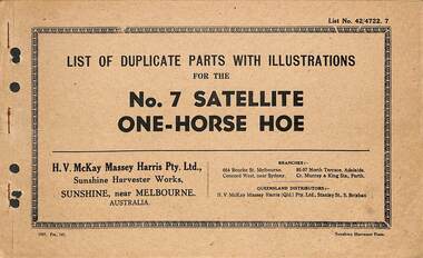
Manual - Sunshine Harvester McKay Massey Harris - List of duplicate parts with illustrations for the No. 7 Satellite One-Horse Hoe, Sunhsine Harvester Press
... Small soft cover booklet stapled along the left spine listing duplicate parts with illustrations for the No. 7 Satellite One-Horse Hoe...McKays Massey Ferguson Sunshine Harvester Works Farm Machinery Small soft cover booklet stapled along the left spine listing duplicate parts with illustrations for the No. 7 Satellite One-Horse Hoe Manual Sunshine Harvester McKay Massey Harris - List of duplicate parts with illustrations for the No. 7 Satellite One-Horse Hoe Sunhsine Harvester Press H.V. ...Ex Museum of Victoria, Lot 2, Box 2 of 3h.v. mckays massey ferguson, sunshine harvester works, farm machinery -
 Eltham District Historical Society Inc
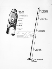
Photograph - Black and White Print, NASA, Four stage solid fuel Scout vehicle and cross section, 1960
... First solid fuel rocket used by N.A.S.A. to launch a satellite on orbital trajectory. Front cap comes off and satellite built of tghin mylar plastic film and aluminium foil emerges and inflates. ...First solid fuel rocket used by N.A.S.A. to launch a satellite on orbital trajectory. Front cap comes off and satellite built of tghin mylar plastic film and aluminium foil emerges and inflates. ...On reverse: Four stage solid fuel Scout vehicle and cross section of payload instrumentation. First solid fuel rocket used by N.A.S.A. to launch a satellite on orbital trajectory. Front cap comes off and satellite built of tghin mylar plastic film and aluminium foil emerges and inflates. Radio beacon built in for tracking.alan gardiner collection, space industry, 1960, nasa, rocket, scout solid fuel rocket -
 Bendigo Military Museum
Photograph - Royal Australian Survey Corps Aerial Surveys, c1980
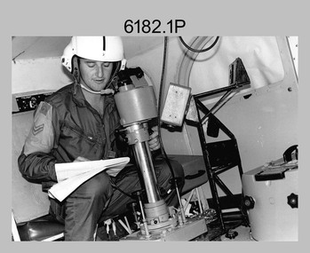
... Introduced in 1974–1975, the Magnavox AN/PRR-14 portable Doppler satellite (US Navy Navigation Satellite System – TRANSIT) receivers and computing system provided independent three-dimensional point positions anywhere in the world, anytime, in any weather accurate to about 1.5metres with precise satellite ephemerides. ...An Australian Army Kiowa helicopter supporting a field survey party undertaking Magnavox AN/PRR-14 portable Doppler satellite observations. ...Introduced in 1974–1975, the Magnavox AN/PRR-14 portable Doppler satellite (US Navy Navigation Satellite System – TRANSIT) receivers and computing system provided independent three-dimensional point positions anywhere in the world, anytime, in any weather accurate to about 1.5metres with precise satellite ephemerides. ...This is a set of nine photographs of technicians from the Royal Australian Survey Corps operating aerial surveys equipment c1980s. In photo .1P, CPL Steve Gloster was operating a RC10 air survey camera mounted in an Australian Army Pilatus Porter aircraft. The Wild RC10 super wide-angle air survey cameras were first introduced in 1971, were equipped with virtual distortion free lenses for supplementary, spot and special photography. In photo .2P, Roger Rees was operating Air Profile Recorder (APR) equipment. it was possibly taken during OP NERVOSE 84, sometime between June – August 1984 when based in Ngukurr, Northern Territory. The APR was operated at this time in unison with an RC10 camera. In 1963 the Royal Australian Survey Corps introduced the radar airborne profile recorder (Canadian Applied Research Ltd, Mark V, Airborne Profiler Recorder) was introduced for 1:100,000 mapping to replace terrain heighting by aneroid barometry. Later in 1974-1975, the Australian developed WREMAPS II airborne laser terrain profile recorder was introduced. In photo .3P, Neil Jones appears at the door of Airsearch Beechcraft Queen Air aircraft, Registration / Serial VH-MWX. This aircraft was typically used by RA Svy on air survey operations flying mission with Aerodist, APR and RC10 camera equipment. The Australian Army’s Pilatus Porter (short take-off and landing turbo propeller) was also equipped with a Wild RC10 aerial mapping camera for identification photography. The Pilatus Porter was also used on RA Svy’s map field checking operations. Photo .9P was taken at a survey station at an unknown location. In this photo an Australian Army Kiowa Light Observation Helicopter (LOH) is supporting a field survey party undertaking Magnavox AN/PRR-14 portable Doppler satellite observations. The satellite receiver’s antenna is plumbed over the survey ground mark surrounded by white plastic panels. The panels were used to identify the survey station on aerial photography. Introduced in 1974–1975, the Magnavox AN/PRR-14 portable Doppler satellite (US Navy Navigation Satellite System – TRANSIT) receivers and computing system provided independent three-dimensional point positions anywhere in the world, anytime, in any weather accurate to about 1.5metres with precise satellite ephemerides. The Bell OH-58 Kiowa LOH was a family of military helicopters used for observation, utility, and direct fire support. It was identified by RA Svy in the mid-1970s that considerable time was lost in replacing unserviceable remote equipment by road. Therefore Aerodist operations (pre-dating satellite receiver operations) were fully supported by Army’s Kiowa LOH aircraft. This is a set of nine photographs of technicians from the Royal Australian Survey Corps operating aerial surveys equipment c1980s. .1P to .3P, .5P to .9P - Colour and black and white photos on photographic paper and scanned at 300 dpi. .4P - Colour photo on 35mm slide film and scanned at 96 dpi. .1) & .2) - Photo, black & white, c1980s, CPL Steve Gloster operating an RC10 air camera. .3) - Photo, colour, 1984, Roger Rees operating Air Profile Recorder (APR) equipment. .4) - Photo, colour, c1980s, Neil Jones at the door of an Airsearch Beechcraft Queen Air aircraft, typically used by RA Svy on air survey operations. .5) - Photo, colour, c1980s. A Beechcraft King Air aircraft, also used by RA Svy on air survey operations. .6) - Photo, colour, c1980s. An Australian Army Pilatus Porter, used by RA Svy on air survey and map field checking operations. SGT Peter Mustart is possibly in the foreground. .7) to .8) - Photo, colour, c1980s. An Australian Army Pilatus Porter and unidentified personnel, used by RA Svy on air survey and map field checking operations. .9) - Photo, colour, c1980s. An Australian Army Kiowa helicopter supporting a field survey party undertaking Magnavox AN/PRR-14 portable Doppler satellite observations. There are biro marks on photos .4P to .9Proyal australian survey corps, rasvy, army survey regiment, asr, fortuna, aerial surveys -
 Whitehorse Historical Society Inc.
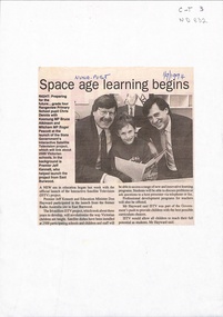
Newspaper - Article, Space age learning begins, 1/09/1994
... Launch of the interactive satellite television project at the former Radio Australia site at East Burwood. ...Whitehorse Historical Society Inc. 2-10 Deep Creek Road Mitcham melbourne interactive satellite television kennett jeff hayward don dennis christopher atkinson bruce education Launch of the interactive satellite television project at the former Radio Australia site at East Burwood. ...Launch of the interactive satellite television project at the former Radio Australia site at East Burwood. It will revolutionise the way Australian children are taught. Students will be able to discuss problems or ask questions to a host presenter via telephone or fax.interactive satellite television, kennett, jeff, hayward, don, dennis, christopher, atkinson, bruce, education -
Tatura Irrigation & Wartime Camps Museum
Book, Department of Agriculture Victoria, Institute for Sustainable Agriculture, Salinity report March 1993, 1993
... Farm planning blueprint. Satellite image of plains and Lodden river. ...Farm planning blueprint. Satellite image of plains and Lodden river. Soft cover Institute for Sustainable Agriculture, Salinity report March 1993 Book Book Department of Agriculture Victoria ...Investigation of salinity problems by staff at Tatura, Kyabram, Shepparton, and Cobram Institutes.Department of Agriculture photos on front. Saline waterlogged land near Shepparton. Measuring white clover growth. Salinity management plans for research. Farm planning blueprint. Satellite image of plains and Lodden river. Soft coverColour photos on front. Dept of Agriculture, Institute for Sustainable Agriculture, Salinity Repory March 1993. back cover multi colourssalinity, department of agriculture, kyabram, tatura, shepparton, cobram -
 Eltham District Historical Society Inc
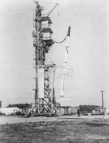
Photograph - Black and White Print, NASA, Four stage Scout solid fuel rocket on launching pad at Wallops Island facility, 1960
... On reverse: Four stage Scout solid fuel rocket on launching pad at Wallops Island facility. First orbital satellite attempt from this base and first with solid fuel rocket....Eltham District Historical Society Inc 728 Main Rd Eltham melbourne Alan Gardiner Collection Space Industry 1960 NASA Rocket Scout Solid Fuel Rocket Virginia Wallops Island On reverse: Four stage Scout solid fuel rocket on launching pad at Wallops Island facility. First orbital satellite attempt from this base and first with solid fuel rocket. ...On reverse: Four stage Scout solid fuel rocket on launching pad at Wallops Island facility. First orbital satellite attempt from this base and first with solid fuel rocket.alan gardiner collection, space industry, 1960, nasa, rocket, scout solid fuel rocket, virginia, wallops island -
Port Melbourne Historical & Preservation Society
Photograph - Double-sided aerial photograph, Hobson's Bay and the Yarra River/Port Phillip and Western Port Bay, Surveyor General and Director of Mapping, Apr 1990
... Port Phillip and Western Port Bays - satellite photo....Port Phillip and Western Port Bays - satellite photo. Photograph Double-sided aerial photograph, Hobson's Bay and the Yarra River/Port Phillip and Western Port Bay Surveyor General and Director of Mapping Port of Melbourne Authority (PMA) Government Printer ...Landsat imagery - an extract from the atlas of VictoriaAerial photos of Port Phillip and Western Port (double sided aerial photographs). 1995 side A: Hobson's Bay and Yarra River - aerial photo mosaic; side B. Port Phillip and Western Port Bays - satellite photo.port of melbourne authority -
 Robin Boyd Foundation
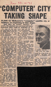
Newspaper - Clipping, The Sun, Computer' city taking shape, 28.10.1971
... Robin Boyd conceived the idea of a satellite city in Sunbury. Computers were used to help with design formulation....Robin Boyd Foundation 290 Walsh Street South Yarra melbourne Robin Boyd conceived the idea of a satellite city in Sunbury. Computers were used to help with design formulation. ...Robin Boyd conceived the idea of a satellite city in Sunbury. Computers were used to help with design formulation.S and date in red pen.sunbury, walsh st library -
 Robin Boyd Foundation
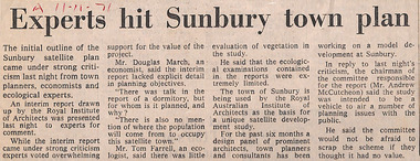
Newspaper - Clipping, The Age (possibly), Experts hit Sunbury town plan, 11.11.71
... Robin Boyd conceived the idea of a satellite city in Sunbury, formulated through the Royal Australian Institute of Architects, Victorian chapter....Robin Boyd Foundation 290 Walsh Street South Yarra melbourne Robin Boyd conceived the idea of a satellite city in Sunbury, formulated through the Royal Australian Institute of Architects, Victorian chapter. ...Robin Boyd conceived the idea of a satellite city in Sunbury, formulated through the Royal Australian Institute of Architects, Victorian chapter.A and date in red pen.sunbury, walsh st library -
Port Melbourne Historical & Preservation Society
Photograph - Double-sided aerial photograph, Hobson's Bay and the Yarra River/Port Phillip and Western Port Bay, Surveyor General and Director of Mapping, Apr 1990
... Port Phillip and Western Port Bays - satellite photo...Port Phillip and Western Port Bays - satellite photo Photograph Double-sided aerial photograph, Hobson's Bay and the Yarra River/Port Phillip and Western Port Bay Surveyor General and Director of Mapping Port of Melbourne Authority (PMA) Government Printer ...Landsat imagery - an extract from the atlas of VictoriaAerial photos of Port Phillip and Western Port (double sided aerial photographs), framed and with timber display stand. 1995 side A: Hobson's Bay and Yarra River - aerial photo mosaic; side B. Port Phillip and Western Port Bays - satellite photomelbourne harbor trust - port of melbourne authority -
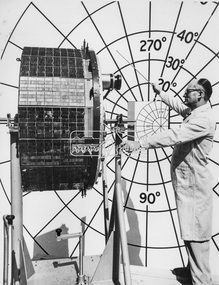
 Eltham District Historical Society Inc
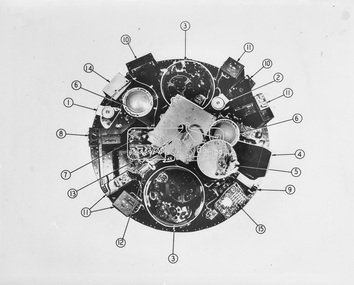
Photograph - Black and White Print, NASA, Tiros II - Taken from above with cover removed, 1960
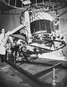
... ...Satellite...Eltham District Historical Society Inc 728 Main Rd Eltham melbourne Alan Gardiner Collection Space Industry 1960 Satellite Tiros II On reverse: Tiros II - Taken from above with cover removed: 1. ...On reverse: Tiros II - Taken from above with cover removed: 1. Wide angle TV camera 2. Narrow angle TV camera 3. TV tape recorders 4. Infra red - 5 channel radiometer 5. Infra red electronics 6. Electronic operations sequence timing 7. Relays for magnetic stabilisation for altitude 8. Control box for electronics 9. Infra red horizon scanner 10. Electronic camera circuits 11. Electronic TV tape circuits 12. Telemetry switches 13. Antenna diplexer (covering storage batteries) 14. Automatic signal generator 15. Fuse board and current regulatoralan gardiner collection, space industry, 1960, satellite, tiros ii -
 Eltham District Historical Society Inc
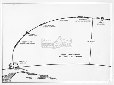
Photograph - Black and White Print, NASA, Tiros II Launch Sequence, 1960
... ...Satellite...Eltham District Historical Society Inc 728 Main Rd Eltham melbourne Alan Gardiner Collection Space Industry 1960 Satellite Tiros II On reverse: Tiros II Launch Sequence Black and white print on photo paper 20.5 x 25 cm Also large format negative (B&W) 11.8 x 16.3 cm Negative copy of photo Tiros II Launch Sequence Photograph Black and White Print NASA ...On reverse: Tiros II Launch Sequencealan gardiner collection, space industry, 1960, satellite, tiros ii -
 Eltham District Historical Society Inc
Photograph - Black and White Print, NASA, Tiros II - Mounted for camera calibration, 1960
... ...Satellite...Eltham District Historical Society Inc 728 Main Rd Eltham melbourne Alan Gardiner Collection Space Industry 1960 Satellite Tiros II On reverse: Tiros II - Mounted for camera calibration. ...On reverse: Tiros II - Mounted for camera calibration. Wide angle camera lens protrudes at upper right.alan gardiner collection, space industry, 1960, satellite, tiros ii -
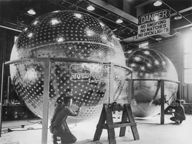 Eltham District Historical Society Inc
Photograph - Black and White Print, NASA, Fully inflated 12 foot diameter sphere as it will appear after ejection, 1960
... ...Satellite...Eltham District Historical Society Inc 728 Main Rd Eltham melbourne Alan Gardiner Collection Space Industry 1960 Satellite NASA On reverse: Fully inflated 12 foot diameter sphere as it will appear after ejection Black and white print 20.5 x 25 cm Also large format negative (B&W) 11.8 x 16.3 cm Negative copy of photo NASA L-60-7424 Fully inflated 12 foot diameter sphere as it will appear after ejection Photograph Black and White Print NASA ...On reverse: Fully inflated 12 foot diameter sphere as it will appear after ejectionalan gardiner collection, space industry, 1960, satellite, nasa -
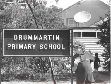 Bendigo Historical Society Inc.
Photograph - PHOTOGRAPH. DRUMMARTIN PRIMARY SCHOOL, 1994
... This looks like the scene outside many country schools over the past century - but for one major change - the Satellite dish on the schools roof. Pictured is g5rade one student Garreth Cail. ...This looks like the scene outside many country schools over the past century - but for one major change - the Satellite dish on the schools roof. Pictured is g5rade one student Garreth Cail. ...Photogrqph. Drummartin Primary School. Rear. Things Don't change much at an old school - or do they. This looks like the scene outside many country schools over the past century - but for one major change - the Satellite dish on the schools roof. Pictured is g5rade one student Garreth Cail. At the schools 120th birthday celebrations. -
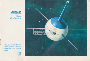 Eltham District Historical Society Inc
Document - Folder, Aerospace Industry, 1958-1961
... Details which Honeywell systems are deployed in the following US Space Industry vehicles: Vanguard space exploration satellite, Discoverer defence rocket, Tiros meteorology satellite, Midas defence rocket, X-15 spy plane, Scout space exploration rocket, Echo communications satellite, Mercury manned flight rocket, Centaur space exploration rocket, Advent communications rocket, Mariner space exploration satellite, Dyna Soar manned manoeuvrable space flight. ...Eltham District Historical Society Inc 728 Main Rd Eltham melbourne Honeywell Scout rocket Echo satellite Mercury rocket Centaur rocket Advent rocket Mariner satellite Dyna Soar X-15 Midas rocket Tiros satellite Discoverer rocket Vanguard satellite aerospace industry Alan Gardiner Collection Space Industry EDHS_06000-2 Folder Aerospace Industry Contents: 1. ...honeywell, scout rocket, echo satellite, mercury rocket, centaur rocket, advent rocket, mariner satellite, dyna soar, x-15, midas rocket, tiros satellite, discoverer rocket, vanguard satellite, aerospace industry, alan gardiner collection, space industry -
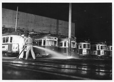 Melbourne Tram Museum
Photograph - Black & White Photograph/s, Herald and Weekly Times, 26/06/1967 12:00:00 AM
... The TV programme was the first world wide made through new overseas satellite systems....The TV programme was the first world wide made through new overseas satellite systems. Photograph Black & White Photograph/s Herald and Weekly Times ...Photographs, Black and White, of: "South Melbourne Depot - re "Our World" TV programme. Hosing the yard to produce a wintry affect. W5 774 at left, then 980, 834, 955, 940. Monday 26/6/67" Herald and Weekly Times photograph with Copyright stamp on rear. The TV programme was the first world wide made through new overseas satellite systems.In ink on the rear: Keith Kings stamp and number S-A-1082 "South Melbourne Depot - re "Our World" TV programme. Hosing the yard to produce a wintry affect. W5 774 at left, then 980, 834, 955, 940. Monday 26/6/67"trams, tramways, south melbourne depot, tv broadcasts, w5 class, sw6 class, tram 774, tram 980, tram 834, tram 955, tram 940, pcc class