Showing 112 items matching "satellites"
-
 Moorabbin Air Museum
Book, Rodney Donald Champness, OUTBACK RADIO from Flynn to Satellites, 2004
... OUTBACK RADIO from Flynn to Satellites...Moorabbin Air Museum Moorabbin Airport 12 First Street Moorabbin melbourne OUTBACK RADIO from Flynn to Satellites Book Rodney Donald Champness ... -
 Sunshine and District Historical Society Incorporated
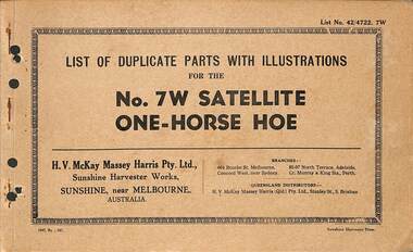
Manual - H.V. McKay Massey Harris - List of duplicate parts with illustrations for the No. 7 W Satellite One-Horse Hoe, SUNSHINE HARVESTER PRESS
... Small soft cover booklet stapled along the left spine listing duplicate parts with illustrations for the No. 7 W Satellite One-Horse Hoe...No. 7 W Satellite One-Horse Hoe...McKays Massey Ferguson Sunshine Harvester Works Farm Machinery No. 7 W Satellite One-Horse Hoe Small soft cover booklet stapled along the left spine listing duplicate parts with illustrations for the No. 7 W Satellite One-Horse Hoe Manual H.V. ...No. 7 W Satellite One-Horse Hoeh.v. mckays massey ferguson, sunshine harvester works, farm machinery -
 Melton City Libraries
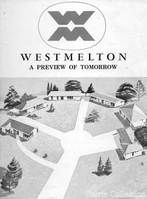
Document, West Melton: A preview of tomorrow, c.1969
... The development, called Westmelton Satellite City, was described as ‘a preview of tomorrow’.101 It was the first estate built in a ‘modern’ style, with curved streets, and dozens of culs de sac. ...A marketing brochure for the Westmelton Satellite City development...Local Significant Events Council A marketing brochure for the Westmelton Satellite City development West Melton: A preview of tomorrow Document Barrie Collection ..."In April 1969, the first major residential development in Melton began with the release of 148 homes for purchase. This was the first stage of a staggered release of a planned 30,000 homes for 100,000 people by 1990. The development, called Westmelton Satellite City, was described as ‘a preview of tomorrow’.101 It was the first estate built in a ‘modern’ style, with curved streets, and dozens of culs de sac. Westmelton was also the first major development in Victoria to build all the supply lines to the houses – including electricity and telephone lines – underground. The six different home designs in Westmelton were ‘specially designed for the future’, and with allotments ten feet wider than regulations required, there was plenty of ‘space for gracious living’ and for a family swimming pool. The developers of this new estate were active in promoting Westmelton as a new community within the Shire of Melton. By 1971, the Westmelton City News reported that Ian McIntosh, General Manager of Westmelton, had given away $100,000 on behalf of the company ‘to aid community projects’. This included a $72,000 donation towards building a community centre in Westmelton, and $25,000 for the shire’s Olympic-sized swimming pool. Ian McIntosh and his family moved to Melton and Ian said he was ‘very much aware of the needs of [the] Westmelton community’. By the end of 1971, Westmelton was home to 100 new families. The modern residences were obviously an appealing drawcard, but so was the country feel that characterised Melton. Mrs C. Allen, described as a ‘housewife’, said she and her husband chose to move to Westmelton because of ‘the quality homes ... and we both love the clean, fresh, natural environment that surrounds us’. Similarly, Mr W. Coxhead, insurance consultant, moved to Westmelton because of the ‘clean, fresh country air’. Accountant Mr B. Swanton echoed their sentiments, describing Westmelton as ‘far enough away from the industrial pollution carried over Melbourne suburbs by prevailing westerly winds’. The new development attracted an increasing number of young, professional couples and families, representing the beginning of a significant shift from the predominantly rural and farming community of the district’s past. The Westmelton development had four different ‘neighbourhoods’ designed to cater to a variety of different lifestyle needs. Westmelton was the first to be established, followed by Brookfield, which offered ‘superb land in a rustic setting’. Brookfield Acres offered ‘wide open spaces with lots of room for a pool and even a tennis court’ on huge one-acre blocks, while Westlake was an innovative development with ‘different sized homesites’ and ‘lakeside living’.Westmelton was the first of many residential developments that would come to play a huge role in shaping the shire in the decades to follow".A marketing brochure for the Westmelton Satellite City developmentlocal significant events, council -
 Queenscliffe Maritime Museum
Print - Melbourne by Satellite by Woman's Weekly c1986, Aerial photo of Port Phillip c1986, c1986
... Colour print insert from Woman's Weekly 1986, 'Melbourne by Satellite'....Print Melbourne by Satellite by Woman's Weekly c1986 ...Port PhillipAerial view of Port Phillip from 705km, 1986.Colour print insert from Woman's Weekly 1986, 'Melbourne by Satellite'.Reverse " Nil " -
 Tennis Australia
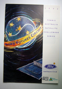
Tournament Programme
... Programme: Tennis Australia Satellite Challenger Series 1992 Materials: Paper, Ink...Tennis Australia Melbourne Park Olympic Boulevard Melbourne Park Melbourne melbourne Tennis Programme: Tennis Australia Satellite Challenger Series 1992 Materials: Paper, Ink Tournament Programme ...Programme: Tennis Australia Satellite Challenger Series 1992 Materials: Paper, Inktennis -
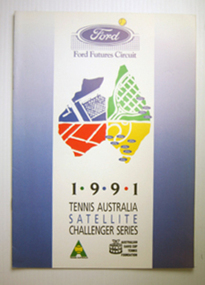 Tennis Australia
Tournament Programme
... Programme: Tennis Australia Satellite Challenger Series 1991 Materials: Paper, Ink...Tennis Australia Melbourne Park Olympic Boulevard Melbourne Park Melbourne melbourne Tennis Programme: Tennis Australia Satellite Challenger Series 1991 Materials: Paper, Ink Tournament Programme ...Programme: Tennis Australia Satellite Challenger Series 1991 Materials: Paper, Inktennis -
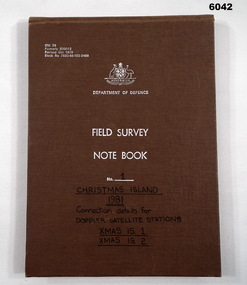 Bendigo Military Museum
Journal - Field Survey Notebook No1 Christmas Island 1981, SSGT JD Mobbs and CPL NF Kelly, Department of Defence, Field survey Notebook No1 Christmas Island 1981, 09.02.1981
... "Connection Details for Doppler Satellite Stations." "Xmas Is 1", "Xmas Is 2"...Kelly, CPL Royal Australian Survey Corps RASvy Fortuna Army Survey Regiment Army Svy Regt ASR "Connection Details for Doppler Satellite Stations." "Xmas Is 1", "Xmas Is 2" Cloth covered Cardboard, 100 Pages, Field Survey Notebook Department of Defence, Field survey Notebook No1 Christmas Island 1981 Journal Field Survey Notebook No1 Christmas Island 1981 SSGT JD Mobbs and CPL NF Kelly ...Notebook compiled by J.D. Mobbs, SSGT and N.F. Kelly, CPLCloth covered Cardboard, 100 Pages, Field Survey Notebook"Connection Details for Doppler Satellite Stations." "Xmas Is 1", "Xmas Is 2"royal australian survey corps, rasvy, fortuna, army survey regiment, army svy regt, asr -
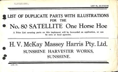 Sunshine and District Historical Society Incorporated
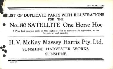
Manual - Sunshine Harvester Mckay Massey Harris - List of duplicate parts with illustrations for the No 80 Satellite One Horse Hoe, H.V. McKay Massey Harris Pty. Ltd
... Small booklet with no cover listing duplicate partw with illustrations for the No. 80 Satellite One Horse Hoe...Small booklet with no cover listing duplicate partw with illustrations for the No. 80 Satellite One Horse Hoe Manual Sunshine Harvester Mckay Massey Harris - List of duplicate parts with illustrations for the No 80 Satellite One Horse Hoe H.V. ...Ex Museum of Victoria - Lot 2, Box 2 of 3"G. Mulkearns" is type-written on the front page.h.v. mckays massey ferguson, sunshine harvester works, farm machinery -
 Eltham District Historical Society Inc
Photograph - Black and White Print, NASA, Tiros II, 1960
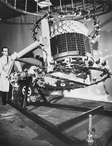
... ...Satellite...On reverse: Tiros II - Satellite mounted in cage to test magnetic stabilisation system....Eltham District Historical Society Inc 728 Main Rd Eltham melbourne Alan Gardiner Collection Space Industry 1960 Satellite Tiros II On reverse: Tiros II - Satellite mounted in cage to test magnetic stabilisation system. ...On reverse: Tiros II - Satellite mounted in cage to test magnetic stabilisation system.alan gardiner collection, space industry, 1960, satellite, tiros ii -
 Eltham District Historical Society Inc
Photograph - Black and White Print, NASA, Tiros II, 1960
... ...Satellite...On reverse: Tiros II - Mounted in machine to test satellite's stabilisation system. Lights test solar cells....Eltham District Historical Society Inc 728 Main Rd Eltham melbourne Alan Gardiner Collection Space Industry 1960 Satellite Tiros II On reverse: Tiros II - Mounted in machine to test satellite's stabilisation system. ...On reverse: Tiros II - Mounted in machine to test satellite's stabilisation system. Lights test solar cells.alan gardiner collection, space industry, 1960, satellite, tiros ii -
 Sunshine and District Historical Society Incorporated
Manual - Sunshine Harvester McKay Massey Harris - List of duplicate parts with illustrations for the No. 80 Satellite One Horse Hoe, H.V. McKay Massey Harris Pty. Ltd
... Small booklet with no cover listing duplicate parts with illustrations for the No. 80 Satellite One Horse Hoe. See also Registration No. 1377...McKays Massey Ferguson Sunshine Harvester Works Farm Machinery Small booklet with no cover listing duplicate parts with illustrations for the No. 80 Satellite One Horse Hoe. See also Registration No. 1377 Manual Sunshine Harvester McKay Massey Harris - List of duplicate parts with illustrations for the No. 80 Satellite One Horse Hoe H.V. ...Ex Museum of Victoria - Lot, Box 2 of 3h.v. mckays massey ferguson, sunshine harvester works, farm machinery -
 Sunshine and District Historical Society Incorporated
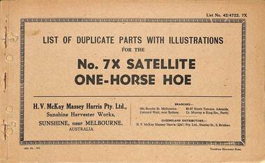
Manual - Sunshine Harvester Mckay Massey Harris - List of duplicate parts with illustrations for the No 7X Satellite One Horse Hoe, SUNSHINE HARVESTER PRESS
... Small soft cover booklet stapled along the left spine listing duplicate parts with illustrations for the No. 7X Satellite One-Horse Hoe...McKays Massey Ferguson Sunshine Harvester Works Farm Machinery Small soft cover booklet stapled along the left spine listing duplicate parts with illustrations for the No. 7X Satellite One-Horse Hoe Manual Sunshine Harvester Mckay Massey Harris - List of duplicate parts with illustrations for the No 7X Satellite One Horse Hoe SUNSHINE HARVESTER PRESS H.V. ...Ex Museum of Victoria - Lot 2, Box 2 of 3h.v. mckays massey ferguson, sunshine harvester works, farm machinery -
 Sunshine and District Historical Society Incorporated
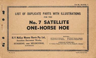
Manual - Sunshine Harvester McKay Massey Harris - List of duplicate parts with illustrations for the No. 7 Satellite One-Horse Hoe, Sunhsine Harvester Press
... Small soft cover booklet stapled along the left spine listing duplicate parts with illustrations for the No. 7 Satellite One-Horse Hoe...McKays Massey Ferguson Sunshine Harvester Works Farm Machinery Small soft cover booklet stapled along the left spine listing duplicate parts with illustrations for the No. 7 Satellite One-Horse Hoe Manual Sunshine Harvester McKay Massey Harris - List of duplicate parts with illustrations for the No. 7 Satellite One-Horse Hoe Sunhsine Harvester Press H.V. ...Ex Museum of Victoria, Lot 2, Box 2 of 3h.v. mckays massey ferguson, sunshine harvester works, farm machinery -
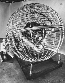
 Eltham District Historical Society Inc
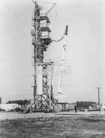
Photograph - Black and White Print, NASA, Four stage solid fuel Scout vehicle and cross section, 1960
... First solid fuel rocket used by N.A.S.A. to launch a satellite on orbital trajectory. Front cap comes off and satellite built of tghin mylar plastic film and aluminium foil emerges and inflates. ...First solid fuel rocket used by N.A.S.A. to launch a satellite on orbital trajectory. Front cap comes off and satellite built of tghin mylar plastic film and aluminium foil emerges and inflates. ...On reverse: Four stage solid fuel Scout vehicle and cross section of payload instrumentation. First solid fuel rocket used by N.A.S.A. to launch a satellite on orbital trajectory. Front cap comes off and satellite built of tghin mylar plastic film and aluminium foil emerges and inflates. Radio beacon built in for tracking.alan gardiner collection, space industry, 1960, nasa, rocket, scout solid fuel rocket -
 Bendigo Military Museum
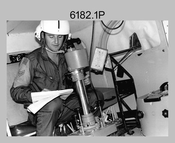
Photograph - Royal Australian Survey Corps Aerial Surveys, c1980
... Introduced in 1974–1975, the Magnavox AN/PRR-14 portable Doppler satellite (US Navy Navigation Satellite System – TRANSIT) receivers and computing system provided independent three-dimensional point positions anywhere in the world, anytime, in any weather accurate to about 1.5metres with precise satellite ephemerides. ...An Australian Army Kiowa helicopter supporting a field survey party undertaking Magnavox AN/PRR-14 portable Doppler satellite observations. ...Introduced in 1974–1975, the Magnavox AN/PRR-14 portable Doppler satellite (US Navy Navigation Satellite System – TRANSIT) receivers and computing system provided independent three-dimensional point positions anywhere in the world, anytime, in any weather accurate to about 1.5metres with precise satellite ephemerides. ...This is a set of nine photographs of technicians from the Royal Australian Survey Corps operating aerial surveys equipment c1980s. In photo .1P, CPL Steve Gloster was operating a RC10 air survey camera mounted in an Australian Army Pilatus Porter aircraft. The Wild RC10 super wide-angle air survey cameras were first introduced in 1971, were equipped with virtual distortion free lenses for supplementary, spot and special photography. In photo .2P, Roger Rees was operating Air Profile Recorder (APR) equipment. it was possibly taken during OP NERVOSE 84, sometime between June – August 1984 when based in Ngukurr, Northern Territory. The APR was operated at this time in unison with an RC10 camera. In 1963 the Royal Australian Survey Corps introduced the radar airborne profile recorder (Canadian Applied Research Ltd, Mark V, Airborne Profiler Recorder) was introduced for 1:100,000 mapping to replace terrain heighting by aneroid barometry. Later in 1974-1975, the Australian developed WREMAPS II airborne laser terrain profile recorder was introduced. In photo .3P, Neil Jones appears at the door of Airsearch Beechcraft Queen Air aircraft, Registration / Serial VH-MWX. This aircraft was typically used by RA Svy on air survey operations flying mission with Aerodist, APR and RC10 camera equipment. The Australian Army’s Pilatus Porter (short take-off and landing turbo propeller) was also equipped with a Wild RC10 aerial mapping camera for identification photography. The Pilatus Porter was also used on RA Svy’s map field checking operations. Photo .9P was taken at a survey station at an unknown location. In this photo an Australian Army Kiowa Light Observation Helicopter (LOH) is supporting a field survey party undertaking Magnavox AN/PRR-14 portable Doppler satellite observations. The satellite receiver’s antenna is plumbed over the survey ground mark surrounded by white plastic panels. The panels were used to identify the survey station on aerial photography. Introduced in 1974–1975, the Magnavox AN/PRR-14 portable Doppler satellite (US Navy Navigation Satellite System – TRANSIT) receivers and computing system provided independent three-dimensional point positions anywhere in the world, anytime, in any weather accurate to about 1.5metres with precise satellite ephemerides. The Bell OH-58 Kiowa LOH was a family of military helicopters used for observation, utility, and direct fire support. It was identified by RA Svy in the mid-1970s that considerable time was lost in replacing unserviceable remote equipment by road. Therefore Aerodist operations (pre-dating satellite receiver operations) were fully supported by Army’s Kiowa LOH aircraft. This is a set of nine photographs of technicians from the Royal Australian Survey Corps operating aerial surveys equipment c1980s. .1P to .3P, .5P to .9P - Colour and black and white photos on photographic paper and scanned at 300 dpi. .4P - Colour photo on 35mm slide film and scanned at 96 dpi. .1) & .2) - Photo, black & white, c1980s, CPL Steve Gloster operating an RC10 air camera. .3) - Photo, colour, 1984, Roger Rees operating Air Profile Recorder (APR) equipment. .4) - Photo, colour, c1980s, Neil Jones at the door of an Airsearch Beechcraft Queen Air aircraft, typically used by RA Svy on air survey operations. .5) - Photo, colour, c1980s. A Beechcraft King Air aircraft, also used by RA Svy on air survey operations. .6) - Photo, colour, c1980s. An Australian Army Pilatus Porter, used by RA Svy on air survey and map field checking operations. SGT Peter Mustart is possibly in the foreground. .7) to .8) - Photo, colour, c1980s. An Australian Army Pilatus Porter and unidentified personnel, used by RA Svy on air survey and map field checking operations. .9) - Photo, colour, c1980s. An Australian Army Kiowa helicopter supporting a field survey party undertaking Magnavox AN/PRR-14 portable Doppler satellite observations. There are biro marks on photos .4P to .9Proyal australian survey corps, rasvy, army survey regiment, asr, fortuna, aerial surveys -
 Eltham District Historical Society Inc
Photograph - Black and White Print, NASA, Four stage Scout solid fuel rocket on launching pad at Wallops Island facility, 1960
... On reverse: Four stage Scout solid fuel rocket on launching pad at Wallops Island facility. First orbital satellite attempt from this base and first with solid fuel rocket....Eltham District Historical Society Inc 728 Main Rd Eltham melbourne Alan Gardiner Collection Space Industry 1960 NASA Rocket Scout Solid Fuel Rocket Virginia Wallops Island On reverse: Four stage Scout solid fuel rocket on launching pad at Wallops Island facility. First orbital satellite attempt from this base and first with solid fuel rocket. ...On reverse: Four stage Scout solid fuel rocket on launching pad at Wallops Island facility. First orbital satellite attempt from this base and first with solid fuel rocket.alan gardiner collection, space industry, 1960, nasa, rocket, scout solid fuel rocket, virginia, wallops island -
 Whitehorse Historical Society Inc.
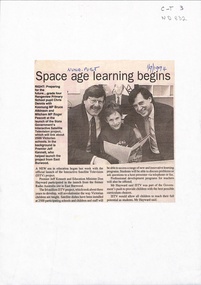
Newspaper - Article, Space age learning begins, 1/09/1994
... Launch of the interactive satellite television project at the former Radio Australia site at East Burwood. ...Whitehorse Historical Society Inc. 2-10 Deep Creek Road Mitcham melbourne interactive satellite television kennett jeff hayward don dennis christopher atkinson bruce education Launch of the interactive satellite television project at the former Radio Australia site at East Burwood. ...Launch of the interactive satellite television project at the former Radio Australia site at East Burwood. It will revolutionise the way Australian children are taught. Students will be able to discuss problems or ask questions to a host presenter via telephone or fax.interactive satellite television, kennett, jeff, hayward, don, dennis, christopher, atkinson, bruce, education -
Tatura Irrigation & Wartime Camps Museum
Book, Department of Agriculture Victoria, Institute for Sustainable Agriculture, Salinity report March 1993, 1993
... Farm planning blueprint. Satellite image of plains and Lodden river. ...Farm planning blueprint. Satellite image of plains and Lodden river. Soft cover Institute for Sustainable Agriculture, Salinity report March 1993 Book Book Department of Agriculture Victoria ...Investigation of salinity problems by staff at Tatura, Kyabram, Shepparton, and Cobram Institutes.Department of Agriculture photos on front. Saline waterlogged land near Shepparton. Measuring white clover growth. Salinity management plans for research. Farm planning blueprint. Satellite image of plains and Lodden river. Soft coverColour photos on front. Dept of Agriculture, Institute for Sustainable Agriculture, Salinity Repory March 1993. back cover multi colourssalinity, department of agriculture, kyabram, tatura, shepparton, cobram -
Port Melbourne Historical & Preservation Society
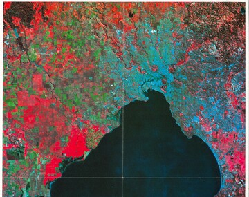
Photograph - Double-sided aerial photograph, Hobson's Bay and the Yarra River/Port Phillip and Western Port Bay, Surveyor General and Director of Mapping, Apr 1990
... Port Phillip and Western Port Bays - satellite photo....Port Phillip and Western Port Bays - satellite photo. Photograph Double-sided aerial photograph, Hobson's Bay and the Yarra River/Port Phillip and Western Port Bay Surveyor General and Director of Mapping Port of Melbourne Authority (PMA) Government Printer ...Landsat imagery - an extract from the atlas of VictoriaAerial photos of Port Phillip and Western Port (double sided aerial photographs). 1995 side A: Hobson's Bay and Yarra River - aerial photo mosaic; side B. Port Phillip and Western Port Bays - satellite photo.port of melbourne authority -
 Robin Boyd Foundation
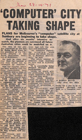
Newspaper - Clipping, The Sun, Computer' city taking shape, 28.10.1971
... Robin Boyd conceived the idea of a satellite city in Sunbury. Computers were used to help with design formulation....Robin Boyd Foundation 290 Walsh Street South Yarra melbourne Robin Boyd conceived the idea of a satellite city in Sunbury. Computers were used to help with design formulation. ...Robin Boyd conceived the idea of a satellite city in Sunbury. Computers were used to help with design formulation.S and date in red pen.sunbury, walsh st library -
 Robin Boyd Foundation
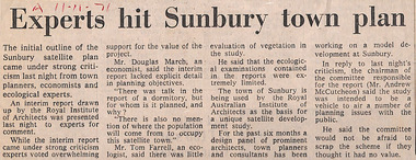
Newspaper - Clipping, The Age (possibly), Experts hit Sunbury town plan, 11.11.71
... Robin Boyd conceived the idea of a satellite city in Sunbury, formulated through the Royal Australian Institute of Architects, Victorian chapter....Robin Boyd Foundation 290 Walsh Street South Yarra melbourne Robin Boyd conceived the idea of a satellite city in Sunbury, formulated through the Royal Australian Institute of Architects, Victorian chapter. ...Robin Boyd conceived the idea of a satellite city in Sunbury, formulated through the Royal Australian Institute of Architects, Victorian chapter.A and date in red pen.sunbury, walsh st library -
Port Melbourne Historical & Preservation Society
Photograph - Double-sided aerial photograph, Hobson's Bay and the Yarra River/Port Phillip and Western Port Bay, Surveyor General and Director of Mapping, Apr 1990
... Port Phillip and Western Port Bays - satellite photo...Port Phillip and Western Port Bays - satellite photo Photograph Double-sided aerial photograph, Hobson's Bay and the Yarra River/Port Phillip and Western Port Bay Surveyor General and Director of Mapping Port of Melbourne Authority (PMA) Government Printer ...Landsat imagery - an extract from the atlas of VictoriaAerial photos of Port Phillip and Western Port (double sided aerial photographs), framed and with timber display stand. 1995 side A: Hobson's Bay and Yarra River - aerial photo mosaic; side B. Port Phillip and Western Port Bays - satellite photomelbourne harbor trust - port of melbourne authority -
 Bendigo Historical Society Inc.
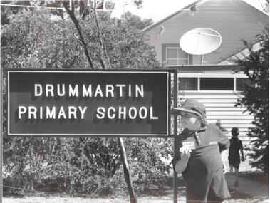
Photograph - PHOTOGRAPH. DRUMMARTIN PRIMARY SCHOOL, 1994
... This looks like the scene outside many country schools over the past century - but for one major change - the Satellite dish on the schools roof. Pictured is g5rade one student Garreth Cail. ...This looks like the scene outside many country schools over the past century - but for one major change - the Satellite dish on the schools roof. Pictured is g5rade one student Garreth Cail. ...Photogrqph. Drummartin Primary School. Rear. Things Don't change much at an old school - or do they. This looks like the scene outside many country schools over the past century - but for one major change - the Satellite dish on the schools roof. Pictured is g5rade one student Garreth Cail. At the schools 120th birthday celebrations. -
 Eltham District Historical Society Inc
Document - Folder, Aerospace Industry, 1958-1961
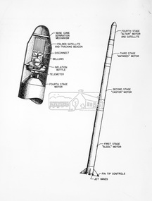
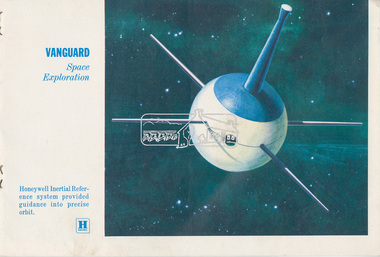
... Document: Table 1 – Satellite Communications Systems, c.1961 14. ...Eltham District Historical Society Inc 728 Main Rd Eltham melbourne Honeywell Scout rocket Echo satellite Mercury rocket Centaur rocket Advent rocket Mariner satellite Dyna Soar X-15 Midas rocket Tiros satellite Discoverer rocket Vanguard satellite aerospace industry Alan Gardiner Collection Space Industry EDHS_06000-2 Folder Aerospace Industry Contents: 1. ...honeywell, scout rocket, echo satellite, mercury rocket, centaur rocket, advent rocket, mariner satellite, dyna soar, x-15, midas rocket, tiros satellite, discoverer rocket, vanguard satellite, aerospace industry, alan gardiner collection, space industry -
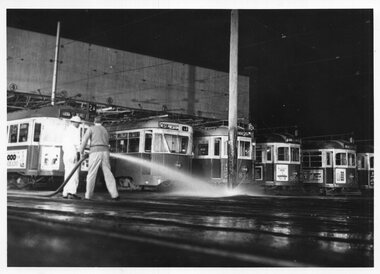 Melbourne Tram Museum
Photograph - Black & White Photograph/s, Herald and Weekly Times, 26/06/1967 12:00:00 AM
... The TV programme was the first world wide made through new overseas satellite systems....The TV programme was the first world wide made through new overseas satellite systems. Photograph Black & White Photograph/s Herald and Weekly Times ...Photographs, Black and White, of: "South Melbourne Depot - re "Our World" TV programme. Hosing the yard to produce a wintry affect. W5 774 at left, then 980, 834, 955, 940. Monday 26/6/67" Herald and Weekly Times photograph with Copyright stamp on rear. The TV programme was the first world wide made through new overseas satellite systems.In ink on the rear: Keith Kings stamp and number S-A-1082 "South Melbourne Depot - re "Our World" TV programme. Hosing the yard to produce a wintry affect. W5 774 at left, then 980, 834, 955, 940. Monday 26/6/67"trams, tramways, south melbourne depot, tv broadcasts, w5 class, sw6 class, tram 774, tram 980, tram 834, tram 955, tram 940, pcc class -
Moorabbin Air Museum
Book - Space flight, Flight into Space
... ...Satellites...Moorabbin Air Museum Moorabbin Airport 12 First Street Moorabbin melbourne Space flight Tests & troubles Guided missiles Satellites Space environment Zero gravity Rocky space Telescopes in space Space radio Vacuum of space Other planets Technical & general overview of the future of spaceflight, circa 1953 Flight into Space Book Space flight ...Technical & general overview of the future of spaceflight, circa 1953non-fictionTechnical & general overview of the future of spaceflight, circa 1953tests & troubles, guided missiles, satellites, space environment, zero gravity, rocky space, telescopes in space, space radio, vacuum of space, other planets -
National Wool Museum
Book, Knitting, Patons Knitting Book no. 583
... Prior to the launch of Sputnik by the Soviets on Oct. 4, 1957, there was little awareness of satellites; also, the Vanguard and the Thor were American rockets launched from Cape Canaveral during the same era. ...Prior to the launch of Sputnik by the Soviets on Oct. 4, 1957, there was little awareness of satellites; also, the Vanguard and the Thor were American rockets launched from Cape Canaveral during the same era. ...This book was owned by the late Dr Elizabeth Kerr and was donated to the Museum by the executor of her estate, Margaret Cameron. It was produced by Patons and Baldwins and contains knitting patterns for mens, womens and childrens garments. This book would appear to have been produced at the time of the Sputnik launch in 1957 - unusually the garments have been given names like 'Supersonic', 'Satellite', 'Thor', 'Nikes', 'Rocket', 'Vanguard', 'Canaveral', and 'Electra'. Prior to the launch of Sputnik by the Soviets on Oct. 4, 1957, there was little awareness of satellites; also, the Vanguard and the Thor were American rockets launched from Cape Canaveral during the same era. As far as is presently known, Patons 'Jet' wool first appeared in the mid 1950s - the name probably represented modernity and was a reflection of the public interest in rockets / jets / supersonic aircraft / space travel which occurred in the post World War II era and which culminated in Sputnik and the formation of NASA in 1958.No. 583 Featuring PATONS JET TRIPLEKNIT / Patons / KNITTING BOOK 583 / WITH T.V. DESIGNS / 2'-knitting handicrafts - history, patons and baldwins (australia) ltd, knitting, handicrafts - history -
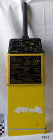 Flagstaff Hill Maritime Museum and Village
Equipment - EPIRB Transmitter
... This model EPIRB relies on four satellites with orbit times of approximately 100 minutes. ...This model EPIRB relies on four satellites with orbit times of approximately 100 minutes. ...This distress EPIRB unit (Emergency Position Indication Radio Beacon) was found on the beach at Levy's Point, Warrnambool, in December 2000 by a Warrnambool resident. Local police were alerted at the time. This distress signal unit is a world-wide COSPAS/SARSAT, satellite assisted, SAR (Search and Rescue) system for location of distress transmissions emitted by an EPIRB. Offshore cruising vessels must have such a unit as part of its essential safety equipment. This model EPIRB relies on four satellites with orbit times of approximately 100 minutes. Earlier units relied solely on aircraft flying overhead to detect and forward on the EPIRB’s location to Search And Rescue authorities, whereas this new system utilises satellites. An employee from the Lokata firm provided additional information about the Lokata EPIRB units. They had a machined aluminium case with labels that were also made on site. The units could be activated manually or automatically released when a magnetic switch in the case casing was activated. This later model, circa 1983, would have been mounted externally on a vessel's bulkhead in a spring-loaded, stainless-steel protective 'skeleton' mounting, The unit released when the water pressure sensor detected a set time it was under the water, in a similar way that life crafts were released. Each unit was registered to a particular vessel - the vessel's details on this unit are indecipherable. The Lokata Company was established in 1970, designing and manufacturing marine products including communications. The company no longer makes products with the “Lokata” brand. In 2001 Sartech Engineering Ltd. took over the support for the Lokata EPIRB beacons. This emergency location device is a late 20th century invention to help save lives at sea. It adds to the history of maritime life, its risks, the lives lost as sea, and the many inventions aimed as rescuing and saving lives. The local area is notorious for the number of lives lost through shipwreck. It also carries stories of heroic efforts to save lives, and other inventions to help reduce the chance of accidents at sea.EPIRB unit; “Emergency Position Indication Radio Beacon”. A distress communication unit for sending a distress location transmission in an emergency at sea. The EPIRB is a yellow, rectangular box with dials, buttons, indicator lights and instruction. An antenna protrudes from the top of the unit. The EPIRB unit sends a 406P (X) EPIRB, with 406M-Hz frequency, 48-hour duration signal. The maker was LOKATA Ltd in England. Remnants of a white label remain on the side. Circa 1980s."NAME OF VESSEL 'SERVICE IF SELF TEST FAILS' " “LO-KATA” moulded into the body. "406P (X) EPIRB" “Model 406” "Lokata Type No 92408" "UK Type approved to MPT 1278" "Class 2" "Made by Lokata Ltd, Falmouth Cornwall England TR10 8AE"" "LOKATE LTD. New North Road Hainault, Ilford Essex IG6 2UR" "ARMED / SAFE / TRANSMIT / CODE / DISPLAY / SET / wait / pass / fail / TEST" "IDENTIFIER / 1349:24034234N" [some characters may be different] "COUNTRY / DENMARK" "VESSEL IDENTITY / 124 [the rest is indecipherable]flagstaff hill, warrnambool, shipwrecked-coast, flagstaff-hill, flagstaff-hill-maritime-museum, maritime-museum, shipwreck-coast, flagstaff-hill-maritime-village, emergency position indicating radio beacon, epirb, lokata ltd, marine safety equipment, satellite transmitting beacon, safety equipment, distress signal, life saving, safety at sea, shipwreck location, lo-kata, falmouth, emergency, beacon, radio signal, communication, marine equipment -
 Grey Street Primary School, Traralgon
Scrapbook, Newspaper Cuttings 1994, 1994
... Items about Preps starting, new principal, 19th Surrey Downs visit, Kosciusko St PS fire, Safety House Program, Junior sports Week, Admin upgrade, tabloid sports carnival, Education Week, Greyathon, restoration work in Traralgon, satellite dishes for interactive learning, Bookweek, Mr Coverdale's American Reunion, Childrens Week, School Fair, PASE courses, Presentation Night...Grey Street Primary School, Traralgon 30-44 Grey Street Traralgon gippsland Items about Preps starting, new principal, 19th Surrey Downs visit, Kosciusko St PS fire, Safety House Program, Junior sports Week, Admin upgrade, tabloid sports carnival, Education Week, Greyathon, restoration work in Traralgon, satellite dishes for interactive learning, Bookweek, Mr Coverdale's American Reunion, Childrens Week, School Fair, PASE courses, Presentation Night Contact covered scrapbook Newspaper Cuttings 1994 Scrapbook ...Items about Preps starting, new principal, 19th Surrey Downs visit, Kosciusko St PS fire, Safety House Program, Junior sports Week, Admin upgrade, tabloid sports carnival, Education Week, Greyathon, restoration work in Traralgon, satellite dishes for interactive learning, Bookweek, Mr Coverdale's American Reunion, Childrens Week, School Fair, PASE courses, Presentation NightContact covered scrapbook -
 Bendigo Military Museum
Booklet - ORTHOPHOTOMAPPING IN THE ROYAL AUSTRALIAN SURVEY CORPS 1977, Army Svy Regt Tech Svcs Jun 77, Jun 1977
... An orthophoto or orthophoto map is a highly accurate geometrically corrected aerial or satellite image where distortions from camera tilt and terrain relief have been removed, resulting in a uniform scale. ...An orthophoto or orthophoto map is a highly accurate geometrically corrected aerial or satellite image where distortions from camera tilt and terrain relief have been removed, resulting in a uniform scale. ...The booklet outlines in detail all aspects of Orthophoto mapping including current equipment, reproduction techniques and the role of orthophoto maps as produced by the Royal Australian Survey Corps. An orthophoto or orthophoto map is a highly accurate geometrically corrected aerial or satellite image where distortions from camera tilt and terrain relief have been removed, resulting in a uniform scale. It therefore acts as a "map accurate" photograph allowing for precise measurements of distances and areas. A4 size booklet of 23 numbered pagesroyal australian survey corps, fortuna, army survey regiment, rasvy, asr