Showing 6 items matching "sawpit gully"
-
 Creswick Campus Historical Collection - University of Melbourne
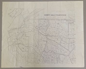
Map - Sawpit Gully Plantation showing plantation lots up to 1976, Sawpit Gully Plantation W.B.P No. 304
... Sawpit Gully Plantation showing plantation lots up to 1976...Sawpit Gully Plantation W.B.P No. 304...Creswick Campus Historical Collection - University of Melbourne 4 Water Street University of Melbourne Creswick Campus Building 719/718 Creswick goldfields Printed map, contours at 25 ft. Sawpit Gully Plantation W.B.P No. 304 Map Sawpit Gully Plantation showing plantation lots up to 1976 ...Printed map, contours at 25 ft. -
 Federation University Historical Collection
Report, Cultural Landscapes Study of Creswick Goldfields Area for Australian Hertiage Commission
... ...sawpit gully...Barker Library (top floor) Mount Helen goldfields goldfields of victoria goldfields tourism marketing tourism creswick creswick goldfields allendale broomfield rocklyn bullengarook mollongghip dean scrub hill clarkes hill creswick railway station creswick school of forestry sawpit gully oak gully creswick cemetery kingston creswick avenue of honour kerrins bridge berry deep leads mine system australasian mine site creswick alluvial workings calembeen park ascot anderson's mill smeaton hepburn lagoon White bound report with clear cover Cultural Landscapes Study of Creswick Goldfields Area for Australian Hertiage Commission Report Chris McConville Chris Olver ...White bound report with clear covergoldfields of victoria, goldfields tourism, marketing, tourism, creswick, creswick goldfields, allendale, broomfield, rocklyn, bullengarook, mollongghip, dean, scrub hill, clarkes hill, creswick railway station, creswick school of forestry, sawpit gully, oak gully, creswick cemetery, kingston, creswick avenue of honour, kerrins bridge, berry deep leads mine system, australasian mine site, creswick alluvial workings, calembeen park, ascot, anderson's mill, smeaton, hepburn lagoon -
Creswick Campus Historical Collection - University of Melbourne
Plant specimen - Sample, 1902
... This sample is of a quarter disc section of sequioa planted in 1902 at Creswick State Nursery in Sawpit Gully by John Johnstone. Cut down in 2015 to make the La Gerche sculpture....Creswick Campus Historical Collection - University of Melbourne 4 Water Street University of Melbourne Creswick Campus Building 719/718 Creswick goldfields This sample is of a quarter disc section of sequioa planted in 1902 at Creswick State Nursery in Sawpit Gully by John Johnstone. Cut down in 2015 to make the La Gerche sculpture. ...This sample is of a quarter disc section of sequioa planted in 1902 at Creswick State Nursery in Sawpit Gully by John Johnstone. Cut down in 2015 to make the La Gerche sculpture.Wood Specimen -
 Federation University Historical Collection
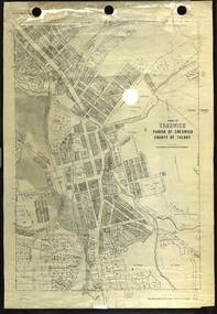
Plan, Creswick, Parish of Creswick, County of Talbot, 1928, 1928
... Parish Plan of Creswick showing Slaty Creek, Old Gold Workings, Police Reserve, Railway Station, Public Gardens, Sawpit Gully, Hospital Reserve, Nigh Soil Depot, Eureka Terracotta Tile COmpany, Creswick Creek, Forest COmmission, Roycroft's Race...creswick Eureka Terracotta Tile Co parish plan Parish Plan of Creswick showing Slaty Creek, Old Gold Workings, Police Reserve, Railway Station, Public Gardens, Sawpit Gully, Hospital Reserve, Nigh Soil Depot, Eureka Terracotta Tile COmpany, Creswick Creek, Forest COmmission, Roycroft's Race Creswick, Parish of Creswick, County of Talbot, 1928 Plan Plan Department of Lands and Survey ...Parish Plan of Creswick showing Slaty Creek, Old Gold Workings, Police Reserve, Railway Station, Public Gardens, Sawpit Gully, Hospital Reserve, Nigh Soil Depot, Eureka Terracotta Tile COmpany, Creswick Creek, Forest COmmission, Roycroft's Racecreswick, eureka terracotta tile co, parish plan -
 Bendigo Historical Society Inc.
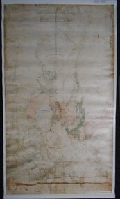
Map - PLAN GENERAL SURVEY MALMSBURY PORCUPINE INN, FOREST CREEK TO GOLDEN POINT. ALEXANDRA RANGE 1853
... Colour Copy of Plan of the General Survey from the Town of Malmsbury to the Porcupine Inn, from the sources of Forest Creek to Golden Point, shewing (sic) the Alexandrian Range also Sawpit Gully Bendigo and Bullock Creeks. Handwritten note under the title a follows '' Forwarded to the Colonial Secretary with my letter No A 53/105 dated 30th March 1853 for transmission to the Geological Surveyor. ...Hoddle Colour Copy of Plan of the General Survey from the Town of Malmsbury to the Porcupine Inn, from the sources of Forest Creek to Golden Point, shewing (sic) the Alexandrian Range also Sawpit Gully Bendigo and Bullock Creeks. Handwritten note under the title a follows '' Forwarded to the Colonial Secretary with my letter No A 53/105 dated 30th March 1853 for transmission to the Geological Surveyor. ...Colour Copy of Plan of the General Survey from the Town of Malmsbury to the Porcupine Inn, from the sources of Forest Creek to Golden Point, shewing (sic) the Alexandrian Range also Sawpit Gully Bendigo and Bullock Creeks. Handwritten note under the title a follows '' Forwarded to the Colonial Secretary with my letter No A 53/105 dated 30th March 1853 for transmission to the Geological Surveyor. R Hoddle Surveyor General. ' Stamped by Department of Mines Victoria with record#123 in Top right Hand corner. Also contains a catalogue number 2053/M/2. Part of the Contents of a DVD entitled 'Mapping Great Change' - Archival Maps, produced to support an exhibition in the Post Office Gallery Bendigo. A description of the Map, its history and implications for both historical and future discussions is contained in an Essay 'Mapping Great Changes' : The landscape of central Victoria by Gerry Gill.R. Hoddlemap, bendigo, country lands -
 Bendigo Historical Society Inc.
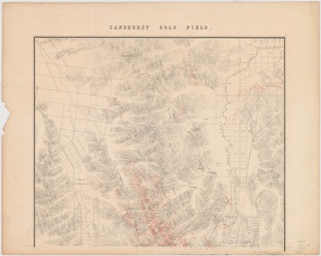
Map - Sandhurst Goldfield 1873, 1873
... On 14 November 1852 Smyth arrived in Melbourne and went to the gold diggings, where he worked as a carter on the construction of roads at Sawpit Gully. Back in Melbourne, on 7 November 1853 he became a draftsman under the surveyor-general, Andrew Clarke, and soon was acting chief draftsman. ...On 14 November 1852 Smyth arrived in Melbourne and went to the gold diggings, where he worked as a carter on the construction of roads at Sawpit Gully. Back in Melbourne, on 7 November 1853 he became a draftsman under the surveyor-general, Andrew Clarke, and soon was acting chief draftsman. ...Robert Brough Smyth (1830-1889), civil servant and mining engineer, was born on 18 February 1830 near Wallsend, Northumberland, England, son of Edward Smith, mining engineer, and his wife Elizabeth, née Brough. On 14 November 1852 Smyth arrived in Melbourne and went to the gold diggings, where he worked as a carter on the construction of roads at Sawpit Gully. Back in Melbourne, on 7 November 1853 he became a draftsman under the surveyor-general, Andrew Clarke, and soon was acting chief draftsman. Smyth compiled numerous reports and wrote catalogues for exhibitions of minerals and fossils. In November 1869 he superintended the establishment of a museum of economic geology, mineralogy and mining and published in Melbourne The Gold Fields and Mineral Districts of Victoria … Covertly involved in the controversy that led to the disbanding of the Geological Survey in 1869, he became its director on its reinstatement in 1871; he increased its part in the search for and proving of economic mineral and coal deposits. In 1875 he became chief inspector of mines and published the geological reports on John Forrest's Western Australian exploration. On 19 June 1860 Smyth had become honorary secretary to the Board for the Protection of Aborigines and in 1863 became a voting member. Zealous and determined, he assumed the role of chairman, which belonged ex officio to the chief secretary, and wielded great power, including the dubious dismissal of John Green, general inspector of Aborigines in 1861-75 with whom he had earlier collaborated. Smyth's compilation, The Aborigines of Victoria … (1878), arose from his efforts to gather information and artefacts of Victorian Aboriginal cultures at a time when their vestiges were fast disappearing. The work, still valuable though long since superseded, relied heavily upon others such as L. Fison, G. B. Halford, A. Howitt and J. Milligan. Press reports and a petition from officers in the Mining Department accused Smyth of 'tyrannical and overbearing conduct', and in February 1876 a board of inquiry was constituted and heard evidence until April. McCoy defended 'one of the best heads of department he had ever known' but the board found the charges of 'excessive severity … in the main substantiated', and reported that Smyth had been irritable, lacking self-control and over-fastidious, but acknowledged his 'unremitting energy and zealous labours in the public service'. On 4 May Smyth resigned all public offices except his membership of the Aborigines' board. Source: Australian Dictionary of Biography. https://adb.anu.edu.au/biography/smyth-robert-brough-4621Original map printed on paper on canvas; copy of map with original. Title: Sandhurst gold field [cartographic material] / surveyed and compiled under the direction of R. Brough Smyth and Thos. Couchman, Angus Mackay ; additions made to the survey under the same direction by Regd. A.F. Murray, April 1873. "Lithd. by R. Shepherd" Topographic map of Sandhurst gold field, with relief shown by hachures. Shows roads, railways and public buildings. "Note - blocks held under leasing regulations are outlined and numbered in red" Map is also available on State Library Victoria: https://find.slv.vic.gov.au/discovery/fulldisplay?vid=61SLV_INST:SLV&search_scope=slv_local&tab=searchProfile&context=L&docid=alma994975393607636 sandhurst, goldfield, lease holdings, gullies, brough smyth, state library of victoria