Showing 219 items matching "sea navigation"
-
 Flagstaff Hill Maritime Museum and Village
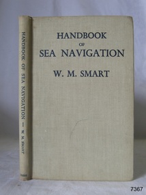
Book - Reference guide, William Marshall Smart (W M Smart), Professor of Astronomy, A Handbook of Sea Navigation, 1943
... A Handbook of Sea Navigation......sea navigation...A Handbook of Sea Navigation: The Theory & Practice of Astronomical Navigation at Sea, with diagrams and charts Author: W M Smart, M.A., D.SC., F.R.A.S. ...Melbourne Frederick Henry (Harry) Slamen 361 Swanston Street Melbourne A Handbook of Sea Navigation Maritime handbook navigation instructiono sea navigation Pencil: "12/6" [12 shillings 6 pence] Sticker: "G.F. ...Author W M Smart, M.A., D.SC., F.R.A.S. (William Marshall Smart), (1889-1975) Regius Professor of Astronomy in the University of Glasgow, Instructor-Lieut. in the Royal Navy during World War I. and John Couch Adams Astronomer in the University of Cambridge. In 1943 he was elected as a fellow of the Royal Society of Edinburg. From 1949-1951 he was President of the Royal Astronomical Society and a member of the Royal Institute of Navigation. In 1958 he was awarded the Lorimer Medal of the Astronomical Society of Edinburgh. The publisher firm, Longmans, Green & Co, was originally founded in 1724 in London by Thomas Longman under the name Longman. In August of that year, he bought the two shops and goods of William Taylor and set up his publishing house there at 39 Paternoster Row. The shops were called Black Swan and Ship, and it is said that the 'ship' sign was the inspiration for Longman's Logo. After many changes of name and management, the firm was incorporated in 1926 as Longmans, Green & Co. Pty Ltd. The firm was acquired by Pearson in 1968 and was known as Pearson Longman or Pearson PLC. The book was sold by Collins Book Depot which was founded by Frederick Henry (Harry) Slamen in 1922. In 1929 the form became a Proprietary Limited Company with an additional two stores, at 95 Elizabeth and 361 Swanston Streets, Melbourne. Collins Booksellers is still owned by the Stamen family. It is the largest Australian-owned bookselling chain.The book is significant due to its connection with navigation at sea. Its author W M Smart was a learned astronomer and an Instructor-Lieutenant for the Royal Navy during World War I. His achievements were recognised in 1958 when he was awarded the Lorimer Medal of the Astronomical Society of Edinburgh.A Handbook of Sea Navigation: The Theory & Practice of Astronomical Navigation at Sea, with diagrams and charts Author: W M Smart, M.A., D.SC., F.R.A.S. (William Marshall Smart) Publisher: Longmans, Green and Co Printer: Collins Book Depot Date: 1943 Textured green hardcover book. Inscriptions on the Fly page.Pencil: "12/6" [12 shillings 6 pence] Sticker: "G.F. Byrne / Faunce Crescent / O'Connor, A.C.T. / Australia 2001" Stamp: "COLLINS BOOK DEPOT PTY. LTD. / Technical Book Department / 361 Swanston St., Melb. G - - -"flagstaff hill, flagstaff hill maritime museum and village, warrnambool, maritime museum, maritime village, great ocean road, shipwreck coast, longmans green and co., thomas longman, paternoster row london, w m smart, william marshall smart, astronomer, navigator, professor of astronomy, 1943, g.f. byrne, collins book depot, technical book department, 361 swanston st., melbourne, frederick henry (harry) slamen, 361 swanston street melbourne, a handbook of sea navigation, maritime handbook, navigation instructiono, sea navigation -
 Moorabbin Air Museum
Book (Item) - Hughes' Tables For Sea And Air Navigation
... Hughes' Tables For Sea And Air Navigation...Hughes' Tables For Sea And Air Navigation...Moorabbin Air Museum Moorabbin Airport 12 First Street Moorabbin melbourne Hughes' Tables For Sea And Air Navigation Book Hughes' Tables For Sea And Air Navigation ... -
 Nhill Aviation Heritage Centre
Book - Reference Book, Hughes' Tables for Sea and Air Navigation, 1938
... Hughes' Tables for Sea and Air Navigation...Nautical Almanac Office Red with gold lettering on spine Hughes' Tables for Sea and Air Navigation Book Reference Book L.J.Comrie ...Red with gold lettering on spinenon-fiction -
 Flagstaff Hill Maritime Museum and Village
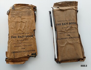
Booklet - Book and World Chart for Emergency Navigation, George Grady Press, The Raft Book, 1943
... ...sea navigation...The booklet included navigational advice and ideas such as ocean currents, estimation of distance, using a compass, measurement of angles, recognising and steering by the stars, land indications from sea birds, migration of sea birds and insects, sounds from the land, the scent of the land and ocean currents and the colour of the sea etc. ...navigation. The contents are folded to take up the least possible space and therefore should not be removed until needed. 2. if the chart and tape are immersed in water for a long period, there will be a slight variation in the scale but the strength and resistence to tear of the paper will not be changed. In the event of long immersion, dry the chart and tape as much as possible before using in order to in order to get the greatest accuracy in scale. Front of booklet - THE RAFT BOOK / LORE OF THE SEA...The two copies of "The Raft Book" are significant as they are a written summary of the many methods of sea navigation (both modern and historical) that existed in the 1940's. ...Harold Gatty was born on January 5th, 1903 in Campbell Town, Tasmania. He was a navigator and aviation pioneer. He began his career learning navigation at the age of 14 as a midshipman at the Royal Australian Naval College but withdrew after three years and became an apprenticed ship's officer with the Patrick Steamship Company of Sydney. After W. W. 1 he joined the Australian Merchant Navy where he learned the constellations while standing night watch and became an expert in celestial navigation while serving on many ships sailing between Australia and California. In 1927 he moved to California and opened a navigation school and also a laboratory repairing navigational equipment. At this time he became very interested in air navigation and was aware of the limitations of existing methods and instruments for aerial navigation. He began researching ways of improving aerial navigation. Two early inventions of his were his air sextant and a ground speed and drift indicator which formed the basis of the automatic pilot which later came to be standard equipment on most aircraft. He worked with several record breaking pilots including Ann Morrow Lindbergh (who went on to serve as a navigator for her husband Charles Lindbergh), helped Wiley Post break the world record circumnavigating the Earth, invented a new method of "dead reckoning" that revolutionised the ability to fly safely through cloudy conditions without drifting off course and famously navigated a small plane (whilst trying to cross the Pacific) over 1900 km through fog (with no radio) and using only his dead reckoning techniques, back to their starting point in Japan after they developed fuel problems. In 1932 Gatty received the Distinguished Flying Cross from President Hoover. In 1934 Gatty formed the South Seas Commercial Company with Donald Douglas with the aim to deliver air services to the islands of the South Pacific. The Company was sold to Pan Am but he continued to work for them. In 1935 he went on a sailing expedition investigating several small islands in the South Pacific and was briefly marooned on Baker Island. He was able to use his extensive knowledge of seabird habits to save the crew. He was also very interested in the ability of the Polynesians to navigate using the stars. During the Second World War Gatty was given the honorary rank of Group Captain in the Royal Australian Air Force (RAAF) and worked for the U. S. Army Air Forces (USAAF) in the South Pacific. In 1943 he moved to Washington where he developed a survival book (The Raft Book) specifically for boat crews or air crews flying over the Pacific to help them survive and navigate their life rafts in remote areas of the ocean. The original book was 152 pages long however a condensed version was made which consisted of a 64 page booklet, combined map and star chart and calendar strip enclosed in a waterproof slipcase, to be placed in life rafts for emergency use. The booklet included navigational advice and ideas such as ocean currents, estimation of distance, using a compass, measurement of angles, recognising and steering by the stars, land indications from sea birds, migration of sea birds and insects, sounds from the land, the scent of the land and ocean currents and the colour of the sea etc. After W.W.2 Gatty moved to Fiji and formed Fiji Airways (which later became Air Pacific). Harold Gatty died in August 1957.The two copies of "The Raft Book" are significant as they are a written summary of the many methods of sea navigation (both modern and historical) that existed in the 1940's. They are also a record of Harold Gatty, who played a significant role in the development of modern day aerial navigation using his understanding of different sea navigational techniques.Two rectangular brown packets with waterproof coverings (oiled paper) titled "The Raft Book" by Harold Gatty. Each packet contains a folded 64 page paper booklet with detailed instructions for navigating a small craft in open seas, a folded chart (with a map of the world and oceans, well known constellations, latitude and longitude charts, Greenwich time and a scale for string lengths and Harp scale) and a long folded paper calendar strip.Front of package - "WATERPROOFED EDITION OF/ THE RAFT BOOK / By Harold Gatty / BOOK AND WORLD CHART / FOR / EMERGENCY NAVIGATION / To open envelope tear along above line. If the envelope is used again fold the flap to keep contents dry. 1. This envelope contains a book, chart and tape for emergency navigation. The contents are folded to take up the least possible space and therefore should not be removed until needed. 2. if the chart and tape are immersed in water for a long period, there will be a slight variation in the scale but the strength and resistence to tear of the paper will not be changed. In the event of long immersion, dry the chart and tape as much as possible before using in order to in order to get the greatest accuracy in scale. Front of booklet - THE RAFT BOOK / LORE OF THE SEA AND SKY /By Harold Gatty IMPORTANT FOR YOUR SECURITY/Upon abandoning ship you may have to be your own navigator. Take the following pre/cautions for your own safety:/ Carry a good type of pocket watch / keep it wound and have it running on Greenwich (England) / Time, which you can get from the navigating officer. / Keep track of the date at Greenwich; and on a 24-hour basis, / know whether the time is, say, 6 hours (6 A.M.) showing on / your watch, or 18 hours (6P.M.) Greenwich. / PROECT YOUR WATCH. GET A RUBBER SACK FOR IT (OBTAIN FROM PHARMACIST) AND KEEP IT DRY / KEEP A PENCIL IN YOUR POCKET/ POSITION OF SHIP WHEN ABANDONED PRINTED IN UNITED STATES OF AMERICA GEORGE GRADY PRESS, NEW YORK/COPYRIGHT, 1943, BY HAROLD AND FENNA GATTYflagstaff hill maritime museum and village, shipwreck coast, warrnambool, the raft book, harold gatty, book and world chart for emergency navigation, ww 2, ww ii, navigation, air navigation, aerial navigation, lindbergh, wiley post, dead reckoning, south seas commercial company, u.s. army airforce, usaaf, survival book, life rafts, sea navigation, emergency navigation, fiji airways, harp scale -
Moorabbin Air Museum
Book (Item) - The Use of Radar at Sea- The Institute of Navigation - by Capt FJ Wylie
... The Use of Radar at Sea- The Institute of Navigation - by Capt FJ Wylie...Moorabbin Air Museum Moorabbin Airport 12 First Street Moorabbin melbourne Book The Use of Radar at Sea- The Institute of Navigation - by Capt FJ Wylie ... -
Box Hill Historical Society
Book, McIntyre, Kenneth Gordon, The Secret Discovery of Australia: Portuguese Ventures 200 Years before Captain Cook, 1977
... An understanding of deep - sea navigation and of the policies that drove the Maritime Powers of Spain and Portugal to compete to rule the world on either side of the Pope's meridian including the Australian coast. ...An understanding of deep - sea navigation and of the policies that drove the Maritime Powers of Spain and Portugal to compete to rule the world on either side of the Pope's meridian including the Australian coast. ...An understanding of deep - sea navigation and of the policies that drove the Maritime Powers of Spain and Portugal to compete to rule the world on either side of the Pope's meridian including the Australian coast. An historical mystery unearthing of secrets that have been kept for hundreds of years. Index; maps; bibliography.explorers, australia, portuguese, mahogany ship -
 Flagstaff Hill Maritime Museum and Village
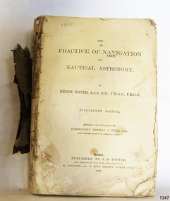
Book - Technical Reference, Henry Raper, Lieut. R.N, The Practice of Navigation and Nautical Astronomy, 1891
... sea...maritime...practical navigation...It includes topics on nautical navigation, astronomy, navigation charts, calculations and mathematical tables, time, tides, ships, longitude, and position at sea. ...navigation Admiralty Charts Henry Raper Thomas A. Hull Royal Navy J D Potter Royal Astronomical Society Royal Geographical Society calculations mathematical tables longitude latitude nautical time location at sea position at sea maritime practical navigation Spottswoode and Co. ...This technical textbook is the nineteenth edition of the book by Henry Raper, Lieutenant in the Royal Navy with awards that include F.R.A.S. (Fellow of the Royal Astronomical Society) and F.R.G.S. (Friend of the Royal Geographical Society). The book is dedicated in honour of Rear-Admiral Sir Francis Beaufort K.C.B., Hydrographer to the Admiralty. He was awarded the title K.C.B. (King's Commander) as a Member of the Order of Bath, an order of British Chivalry, The book was first published in 1840 and soon became a resource for navigation students. It includes topics on nautical navigation, astronomy, navigation charts, calculations and mathematical tables, time, tides, ships, longitude, and position at sea. Thomas A. Hull, who revised and expanded this edition, was a Commander in the Royal Navy and had previously been Superintendent of Admiralty Charts used for navigation worldwide by seamen from many walks of life. The publisher, J D Potter of London, was at that time the sole agent for the Admiralty Charts produced by the Royal Navy. Printer Spottswoode and Co.,. was established by William Strachan in 1738. In 1819 his nephews A and R Spottswoode took over the business and bought premises in New-Street Square and Shoe Lane. In 1850 over 200 workers were employed by the firm. and five years later the business became Spottswoode & Co. Andrew Spottswoode invented the Spottswoode Press.This technical book was very popular as a textbook for students of maritime navigation, written and updated by members of the British Royal Navy and relied upon for accurate advice and information. The first edition was published in 1840, this edition was updated, expanded and published in 1891 when ports around the world were filling with travellers, merchants and business people. Title: The Practice of Navigation and Nautical Astronomy Author: Henry Raper, Lieut, R.N., F.R.A.S., F.R.G.S. Nineteenth Edition, revised and enlarged by Commander Thomas A. Hull, R.N., Late Superintendant of Admiralty Charts Dedication: To Rear-Admiral Sir Francis Beaufort K.C.B. Publisher: J D Potter, London, sole agent for the sale of Admiralty Charts Printer: Spottswoode and Co. New-Street Square, London Date: 1891 Small leather hardcover book with gold embossed text and lines on the spine. The Dedication in the book is as follows: - "To Rear-Admiral Sir Francis Beaufort K.C.B. Hydrographer to the Admiralty. Sir, The eminent station which you occupy in the naval scientific world renders it highly gratifying to me to dedicate the following Work to you as a testimony of my regard and esteem; while the general accordance of my views on the subject with those of your more experienced judgement, gives me the greater confidence in laying my labours before the Public. I have the honour to be, Sir, Your obedient servant, HENRY RAPER"flagstaff hill maritime museum, maritime museum, shipwreck coast, flagstaff hill, warrnambool, flagstaff hill maritime village, book, navigation, nautical astronomy, hydrography, nautical charts, nautical navigation, astronomical navigation, admiralty charts, henry raper, thomas a. hull, royal navy, j d potter, royal astronomical society, royal geographical society, calculations, mathematical tables, longitude, latitude, nautical time, location at sea, position at sea, maritime, practical navigation, spottswoode and co., sir francis beaufort, k.c.b., rear-admiral sir francis beaufort, hydrographer to the admiralty, scientific book, naval science -
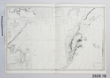 Flagstaff Hill Maritime Museum and Village
Document - Navigation Chart, Sea of Okhotsk
... British Admiralty Navigation Chart - Sea of Okhotsk...Flagstaff Hill Maritime Museum and Village 89 Merri Street Warrnambool great-ocean-road Warrnambool Shipwrecked-coast Flagstaff-Hill Flagstaff-Hill-Maritime-Museum Maritime-Museum Shipwreck-coast Flagstaff-Hill-Maritime-Village Shipwrecked-artefact Navigation Chart British Admiralty Navigation Chart British Admiralty Navigation Chart - Sea of Okhotsk Sea of Okhotsk Document Navigation Chart ...British Admiralty Navigation Chart - Sea of Okhotskwarrnambool, shipwrecked-coast, flagstaff-hill, flagstaff-hill-maritime-museum, maritime-museum, shipwreck-coast, flagstaff-hill-maritime-village, shipwrecked-artefact, navigation chart, british admiralty navigation chart -
 Warrnambool and District Historical Society Inc.
Book, The Practical Measurer, 1863
... Navigation Company for 16 years. Osborne wrote many articles with nautical themes using the nom-de-plume of ‘Sliding Gunter’ and had a great love of, and interest in, the ship, ‘Julia Percy’ and when he died in 1902 his body was put on board the ‘Julia Percy’ and he was buried at sea. ...Navigation Company for 16 years. Osborne wrote many articles with nautical themes using the nom-de-plume of ‘Sliding Gunter’ and had a great love of, and interest in, the ship, ‘Julia Percy’ and when he died in 1902 his body was put on board the ‘Julia Percy’ and he was buried at sea. ...This book, ‘The Practical Measurer’, by Alexander Peddie, is subtitled ‘Tradesman and Wood Merchant’s Assistant’. It is a tradesman’s guide to measuring and contains many tables of measurement. The inscription in the front of the book shows that it belonged to Thomas Osborne and that he obtained it from D. McColl who is identified in the inscription as the Chief Engineer of the steam ship, ‘Julia Percy’. There is a record of a Donald McColl owning the vessel ‘Mimmie Dyke’ and sailing it to Mauritius in 1856 and there is also a record of the death of a Donald McColl in 1880 so these two facts may refer to the D.McColl mentioned by Thomas Osborne (especially as he refers to him as ‘poor old Mr D. McColl’). Thomas Hamilton Osborne was born in Port Fairy in 1851. He had a lifelong interest in ships and in Warrnambool was the Secretary and then Manager of the Western Steam Navigation Company for 16 years. Osborne wrote many articles with nautical themes using the nom-de-plume of ‘Sliding Gunter’ and had a great love of, and interest in, the ship, ‘Julia Percy’ and when he died in 1902 his body was put on board the ‘Julia Percy’ and he was buried at sea. The ‘Julia Percy’ (built 1876) was a well-known steamship on the western Victorian coast for many years. Later it plied the Queensland coast, saw service in West Australian waters, was renamed the ‘Leeuin’ and was used as a coal hulk until it was scuttled in 1935. The signature in the book of T. Hyland may indicate that he donated the book to the Warrnambool and District Historical Society. This book is of prime importance because:- 1. As a book printed in 1863 it is of antiquarian interest. 2. The connection with Thomas Osborne is of key interest as he was a notable figure in Warrnambool’s 19th century history, especially in maritime circles. 3. The connection with the ship, ‘Julia Percy’, is of particular interest as it was a prominent ship in Warrnambool’s maritime history. This is a hard cover book of 448 pages with brown and gold leather binding on the spine and cover edges and a brown and tan mottled pattern cover. The book has a Preface, a Contents page, information on how to measure all types of solid figures and how to measure work involved in the various trades – masons, carpenters, painters, glaziers, plumbers etc. It also has two Appendices with information on the measurement of sawn timber. The text has many tables and diagrams. The first page has a handwritten inscription in black ink and the back pages have some mathematical calculations written in pencil and a mathematical problem with its solution written in ink. Handwritten: ‘T. P. Hyland’ Stamped: ‘T.H.Osborne’ Typed label: ‘Mr T. H. Osborne, Warrnambool’ Handwritten: ‘T.H. Osborne, Warrnamool, Australia, given to me by poor old Mr D. McColl, Chf. Engineer, Julia Percy S.S., 1888’ thomas osborne, history of warrnambool, maritime history of victoria, ‘julia percy’ steamship -
 Warrnambool and District Historical Society Inc.
Documents, Letters to Sliding Gunter, 1902
... Navigation Company becoming manager in 1883. After the company failed he joined with Mark Saltau and they traded as Saltau and Osborne. His writings as Sliding Gunter appeared in The Warrnambool Standard and the Belfast Gazette. He was knowlegable and maintained an interest in shipping and the sea...Navigation Company becoming manager in 1883. After the company failed he joined with Mark Saltau and they traded as Saltau and Osborne. His writings as Sliding Gunter appeared in The Warrnambool Standard and the Belfast Gazette. He was knowlegable and maintained an interest in shipping and the sea ...Sliding Gunter was the nom de Plume of Thomas Hamilton Tracey Osborne. Thomas Hamilton Tracey Osborne was born at Belfast 4/9/1851, the son of Thomas Hamilton Trail Osborne and his second wife Eliza nee Treacey. The young Thomas spent many hours among seamen and ships at Port Fairy. He moved to Warrnambool and commenced work as secretary to the Western Steam Navigation Company becoming manager in 1883. After the company failed he joined with Mark Saltau and they traded as Saltau and Osborne. His writings as Sliding Gunter appeared in The Warrnambool Standard and the Belfast Gazette. He was knowlegable and maintained an interest in shipping and the sea. He died in 11th December 1902 and his body was taken on board the Julia Percy and was buried at sea out from the Breakwater. He was well liked in the district and people lined the Cannon Hill area and the foreshore to farewell him. As an avid writer he corresponded with many people and this letter is one such letter The writer J J Crawford from Koroit tells the story of some of his family and their travels to Australia and early years in South Australia. The contents of letters such as these show he drew information from various sources.These letters as they relate to one of Warrnambool's earliest writers hold historic and social significance.002192.1 Plain white paper letter handwritten in black ink on back and front of letter 002192.2 Plain white paper letter handwritten in black ink on front and section on the back written sideways. Both letters are in the same hand.002192.1 dated 27 Feb 1902, Koroit. Signed J J Crawford 002192.2 Dated 1 March 1902, Koroit.sliding gunter -
 Warrnambool and District Historical Society Inc.
Document, Letter to Mr J H Osborne 1901, 1901
... Navigation Company becoming manager in 1883. After the company failed he joined with Mark Saltau and they traded as Saltau and Osborne. His other main interest was writing some of which he did under the nom de plume of Sliding Gunter. These articles appeared in The Warrnambool Standard and the Belfast Gazette. He was knowlegable and maintained an interest in shipping and the sea...Navigation Company becoming manager in 1883. After the company failed he joined with Mark Saltau and they traded as Saltau and Osborne. His other main interest was writing some of which he did under the nom de plume of Sliding Gunter. These articles appeared in The Warrnambool Standard and the Belfast Gazette. He was knowlegable and maintained an interest in shipping and the sea ...Thomas Hamilton Tracey Osborne was born at Belfast 4/9/1851, the son of Thomas Hamilton Trail Osborne and his second wife Eliza nee Treacey. The young Thomas spent many hours among seamen and ships at Port Fairy. He moved to Warrnambool and commenced work as secretary to the Western Steam Navigation Company becoming manager in 1883. After the company failed he joined with Mark Saltau and they traded as Saltau and Osborne. His other main interest was writing some of which he did under the nom de plume of Sliding Gunter. These articles appeared in The Warrnambool Standard and the Belfast Gazette. He was knowlegable and maintained an interest in shipping and the sea. He died in 11th December 1902 and his body was taken on board the Julia Percy and was buried at sea out from the Breakwater. He was well liked in the district and people lined the Cannon Hill area and the foreshore to farewell him. As an avid writer he corresponded with many people and this letter is one such letter. It relates to recollections of the wreck of the Maria in 1840 out of Adelaide and the loss of life which followed. Unfortunately the letter is incomplete.This letter is of interest as it is addressed to one of Warrnambool's interesting people at the turn of the 20th century. Thomas Hamilton Tracey Osborne has left a legacy of much written work which records aspects of Warrnambool's history as well as his interest in ships and seafaring. This letter shows he drew his information from various sources.One lined page of a letter written in black pen. A wide margin on the left side of the page . The back is blank.The letter is addressed to Mr T H Osborne. Date November 30th 1901.thomas hamilton tracey osborne, western steam navigation company, saltau and osborne, 1901 letter, wreck of the maria 1840 -
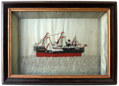 Warrnambool and District Historical Society Inc.
Textile - Casino embroidery, S.S. Casino
... Navigation Company bought the ship. It was used as a coastal steamer solely on the west coast of Victoria run from 1882. On the morning of 10th July 1932 an attempt was made to berth the ship at Apollo Bay in heavy seas. ...Navigation Company bought the ship. It was used as a coastal steamer solely on the west coast of Victoria run from 1882. On the morning of 10th July 1932 an attempt was made to berth the ship at Apollo Bay in heavy seas. ...The SS Casino was a coastal trader of 450 tons gross, 160.4 feet in length, built at Dundee for the Newcastle and Hunter Steam Navigation Company. It had saloon accommodation for 35 people, fore-cabin 25 and carried 300 tons (425 tonnes) of cargo.The Casino called at Warrnambool on 30th May 1882 while on her delivery voyage and narrowly escaped being dragged ashore by gale force winds. While the ship was in Warrnambool the directors of the Belfast and Koroit Steam Navigation Company bought the ship. It was used as a coastal steamer solely on the west coast of Victoria run from 1882. On the morning of 10th July 1932 an attempt was made to berth the ship at Apollo Bay in heavy seas. Captain Middleton decided to take the ship out into the bay and wait until the seas abated, not realising that the anchor used to steady the ship as she was being manoeuvred had pierced her hull. The ship was put about and headed to the beach, but sank. The captain and four crew members were swept off the deck, and though one crew member was rescued, four drowned. The beaded picture was made by Mary Wickham, the grandmother of the donor. This item has significance linking a piece of handcraft and a local ship from the late 19th century.It has significant artistic value. Hand worked embroidery of black, white, maroon, gold & clear glass beads on a background of white polished cotton. The embroidery is in a black painted wooden frame. It is backed by a sheet of "War Cry" 26th April 1896. "Casino" in gold beading on bow of ship.the casino ship, warrnambool casino, warrnambool shipwrecks -
 Warrnambool and District Historical Society Inc.
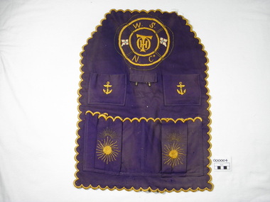
Textile - Work Apron, 1883-1899
... Navigation Company. He was Company manager in 1883 until its dissolution in 1899. Osborne wrote many articles on early Warrnambool, particularly maritime material under the name of " Sliding Gunter". When he died he was buried at sea...Navigation Company. He was Company manager in 1883 until its dissolution in 1899. Osborne wrote many articles on early Warrnambool, particularly maritime material under the name of " Sliding Gunter". When he died he was buried at sea ...The personal 'carry-all', a cloth apron like article was utilised by Thomas Hamilton Osborne in his work with the Warrnambool Steamship Navigation Company. He was Company manager in 1883 until its dissolution in 1899. Osborne wrote many articles on early Warrnambool, particularly maritime material under the name of " Sliding Gunter". When he died he was buried at sea off the breakwater.His sister Mrs Annabella Kell is thought to have made this article.This is a significant item as T.H.Osborne was a key figure in 19th Century Warrnambool history, particularly in maritime affairs. Six sided, scalloped edges, four pockets, two metal hooks, purple woven fabric with yellow and gold embroidery, lifebuoy outline with W.S.N.Co and THO initials embroidered and two flags. Machine sewing of pockets and tab to base apron.W.S.N.Co THO initials on top of each other Two metal hookswork apron, warrnambool steamship navigation company, wsnc, thomas hamilton tracey osborne, annabella kell, sliding gunter -
 Flagstaff Hill Maritime Museum and Village
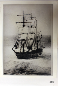
Photograph, post 1889
... sea battered the hull to pieces. The Marine Board inquiry found the wreck was caused by a "one man style of navigation" and that the Captain had not heeded the advice of his crew. ...sea battered the hull to pieces. The Marine Board inquiry found the wreck was caused by a "one man style of navigation" and that the Captain had not heeded the advice of his crew. ...The photograph shows the three-masted iron and steel bark "Newfield" sailing in open seas. It event would have been between 1889-1892 during the ship's working life. ABOUT THE NEWFIELD The Newfield was a three-masted iron and steel barque, built in Dundee, Scotland, in 1889 by Alexander Stephen and Sons. It was owned by the Newfield Ship Company in 1890 and later that year It was registered in Liverpool to owners Brownells and Co. The Newfield left Sharpness, Scotland, on 28th May 1892 with a crew of 25 under the command of Captain George Scott and on 1st June left Liverpool. She was bound for Brisbane, Australia, with a cargo of 1850 tons of fine rock salt, the main export product of Sharpness. At about 9pm on 28th August 1892, in heavy weather, Captain Scott sighted, between heavy squalls, the Cape Otway light on the mainland of Victoria but, due to a navigational error (the ship’s chronometers were wrong), he assumed it to be the Cape Wickham light on King Island, some 40 miles south. He altered his course to the north, expecting to enter Bass Strait. The ship was now heading straight for the south west Victorian coast and at about 1:30am ran aground on a reef about 100 yards from shore and one mile east of Curdie’s Inlet, Peterborough. The ship struck heavily three times before grounding on an inner shoal with 6 feet of water in the holds. Rough sea made the job of launching lifeboats very difficult. The first two lifeboats launched by the crew were smashed against the side of the ship and some men were crushed or swept away. The third lifeboat brought eight men to shore. It capsized when the crew tried to return it to the ship for further rescue The Port Campbell rocket crew arrived and fired four rocket lines, none of which connected with the ship. A local man, Peter Carmody, volunteered to swim one mile to the ship with a line to guide the fourth and final lifeboat safely to shore. Seventeen men survived the shipwreck but the captain and eight of his crew perished. One of the men, apprentice William McLeod, was rescued by local woman Margaret E. MacKenzie. The Newfield remained upright on the reef with sails set for a considerable time as the wind slowly ripped the canvas to shreds and the sea battered the hull to pieces. The Marine Board inquiry found the wreck was caused by a "one man style of navigation" and that the Captain had not heeded the advice of his crew. According to Jack Loney ‘… when the drama was over . . the Newfield was deserted except for the Captain’s dog and two pigs.’ Flagstaff Hill Maritime Museum has several artefacts that have been salvaged from the wreck. The report from SHP documented the following in regards to the Newfield collection: Flagstaff Hill’s collection of artefacts from the Newfield is of historical and archaeological significance at a State level, because of its association with the shipwreck, which is on the Victorian Heritage Register. The collection is significant because of its relationship between the objects. The Newfield collection is archaeologically significant as it is the remains of an international cargo ship. The Newfield collection is historically significant for representing aspects of Victoria’s shipping history and its potential to interpret sub-theme 1.5 (Living with natural processes). The collection is also historically significant for its association with the shipwreck. Black and white photograph of the three-masted sailing ship “Newfield” in the open sea, sails unfurled. The ship was built in 1859 by Alexander Stephen and Sons Limited of Dundee, Scotland. flagstaff hill, warrnambool, shipwrecked-coast, flagstaff-hill, flagstaff-hill-maritime-museum, maritime-museum, shipwreck-coast, flagstaff-hill-maritime-village, barque newfield, photograph, 1880s sailing ship -
 Flagstaff Hill Maritime Museum and Village
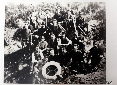
Photograph - Ship Crew, 1889-1892
... sea battered the hull to pieces. The Marine Board inquiry found the wreck was caused by a "one man style of navigation" and that the Captain had not heeded the advice of his crew. ...sea battered the hull to pieces. The Marine Board inquiry found the wreck was caused by a "one man style of navigation" and that the Captain had not heeded the advice of his crew. ...This black and white photograph shows the crew of the barque Newfield. They are pictured seated on a grassy slope and rock, a lifebuoy from the Newfield, Liverpool, resting on the men in the front row. The men are formally dressed, some with bowler hats, a bow tie and pipe, rather than in their sailing uniforms. ABOUT THE NEWFIELD The Newfield left Sharpness, Scotland, on 28th May 1892 with a crew of 25 under the command of Captain George Scott and on 1st June left Liverpool. She was bound for Brisbane, Australia, with a cargo of 1850 tons of fine rock salt, the main export product of Sharpness. At about 9pm on 28th August 1892, in heavy weather, Captain Scott sighted, between heavy squalls, the Cape Otway light on the mainland of Victoria but, due to a navigational error (the ship’s chronometers were wrong), he assumed it to be the Cape Wickham light on King Island, some 40 miles south. He altered his course to the north, expecting to enter Bass Strait. The ship was now heading straight for the south west Victorian coast. At about 1:30am the Newfield ran aground on a reef about 100 yards from shore and one mile east of Curdie’s Inlet, Peterborough. The ship struck heavily three times before grounding on an inner shoal with 6 feet of water in the holds. Rough sea made the job of launching lifeboats very difficult. The first two lifeboats launched by the crew were smashed against the side of the ship and some men were crushed or swept away. The third lifeboat brought eight men to shore. It capsized when the crew tried to return it to the ship for further rescue The rescue was a difficult operation. The Port Campbell Rocket Crew arrived and fired four rocket lines, none of which connected with the ship. Peter Carmody, a local man, volunteered to swim about one mile off shore to the ship with a line to guide the fourth and final lifeboat safely to shore. He was assisted by James McKenzie and Gerard Irvine. Seventeen men survived the shipwreck but the captain and eight of his crew perished. The Newfield remained upright on the reef with sails set for a considerable time as the wind slowly ripped the canvas to shreds and the sea battered the hull to pieces. The Marine Board inquiry found the wreck was caused by a "one man style of navigation" and that the Captain had not heeded the advice of his crew. According to Jack Loney ‘… when the drama was over . . the Newfield was deserted except for the Captain’s dog and two pigs.’ Peter Carmody was awarded the Bramley Moore medal by the Liverpool Shipwreck and Humane Society for Saving Life at Ssea, which he received by mail on January 21st 1893. Flagstaff Hill’s collection of artefacts from the Newfield is significant for its association with the shipwreck Newfield, which is listed on the Victorian Heritage Registry. The collection is significant because of the relationship between the objects. The Newfield collection is archaeologically significant as the remains of an international cargo ship. The Newfield collection is historically significant for representing aspects of Victoria’s shipping history and its association with the shipwreck. The Letter accompanying the Medal for Bravery awarded to Peter Carmody is significant because the attempt to save lives is associated with the shipwreck Newfield. Black and white photograph of the crew of the sailing ship “Newfield”. The men in formal dress are seated on rocky slope with the ship’s lifebuoy showing the name “NEWFIELD, LIVERPOOL”. Photograph taken 1889-1892 flagstaff hill, warrnambool, shipwrecked-coast, flagstaff-hill, flagstaff-hill-maritime-museum, maritime-museum, shipwreck-coast, flagstaff-hill-maritime-village, newfield, photograph, crew of the newfield, 19th century sailing ship, peterborough, cape otway, medal for bravery -
 Flagstaff Hill Maritime Museum and Village
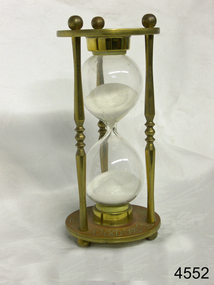
Instrument - Hourglass
... sea were gradually replaced in the late 1700’s to early 1800’s by the more accurate chronometers (marine clocks) when they became reliable instruments. DEAD RECKONING (or Deduced Reckoning) Dead reckoning is the term used to describe the method of calculating the ship’s position from its speed and direction, used in early maritime travel, mostly in European waters. Both the (1) speed and the (2) direction of travel were recorded on a Traverse Board at half-hourly intervals during a helmsman’s watch of 4 hours. The navigator would record the readings in his ship’s log, plot them on his navigational...sea were gradually replaced in the late 1700’s to early 1800’s by the more accurate chronometers (marine clocks) when they became reliable instruments. DEAD RECKONING (or Deduced Reckoning) Dead reckoning is the term used to describe the method of calculating the ship’s position from its speed and direction, used in early maritime travel, mostly in European waters. Both the (1) speed and the (2) direction of travel were recorded on a Traverse Board at half-hourly intervals during a helmsman’s watch of 4 hours. The navigator would record the readings in his ship’s log, plot them on his navigational ...An hourglass or sandglass is an instrument for measuring a defined time and can be used perpetually by simply turning it over immediately the top bulb empties. The clear blown glass is shaped into two equal sized bulbs with a narrow passage in the centre and contains uniform sized sand or glass particles in the lower bulb. The width of the neck regulates the constant flow of the particles. The glass is held in a stand with top and bottom of equal shape and size. Hourglasses can measure an infinite variety of time by gauging the size of the particles, the shape and size of the bulbs and the size of the passage between the bulbs, thus measuring hours or minutes or even seconds. Generally an hourglass sits between discs of wood at the ends, which are joined by long wooden spindles between the ends and tightened by screw caps. The length of time can be adjusted by adding or removing sand particles. The use of the marine sandglass (or hourglass) has been recorded in the 14th century in European shipping. A one minute sandglass was used in conjunction with the ship’s log for ‘dead reckoning’, (see below) that is, for measuring the ship’s speed through the water. They were also used to regulate ringing the ship’s timetable; for example a 4 hour sandglass was used for the length of the sailors’ watch, and a half hour timer for taking of readings for the ship’s log; the ship’s bell would be rung every half hour. It was usually the role of the cabin boy to watch and turn the sandglasses over at the exact time of them emptying their upper chambers and to ring the ship’s bell. Hourglasses have been used historically for many hundreds of years. Some have been used for timing church sermons, in cooking, in industry and at sea. Even today they are used for measuring the cooking time of eggs and timing a player’s turn in games such as Boggle and Pictionary. The sandglasses at sea were gradually replaced in the late 1700’s to early 1800’s by the more accurate chronometers (marine clocks) when they became reliable instruments. DEAD RECKONING (or Deduced Reckoning) Dead reckoning is the term used to describe the method of calculating the ship’s position from its speed and direction, used in early maritime travel, mostly in European waters. Both the (1) speed and the (2) direction of travel were recorded on a Traverse Board at half-hourly intervals during a helmsman’s watch of 4 hours. The navigator would record the readings in his ship’s log, plot them on his navigational chart and give his updated course directions to the next helmsman on watch, along with the cleared Traverse Board. This was a very approximate, but none-the-less helpful, method of navigation. The wooden Traverse Board was a simple pegboard with a diagram of a compass with eight peg holes along the radius to each of the compass points, plus a grid with ascending half hours in the left column and increasing ship’s speed in knots in a row across the column headings, with a peg hole in each of the intersecting cells. A number of wooden pegs were attached to strings on the board. By placing one peg consecutively in the direction’s radius hole, starting from the centre, and the speed holes when the half hourly reading was taken, a picture of speed and direction for the whole 4 hour watch was created. (1) To measure the ship’s speed a one minute hourglass timer was usually used to measure the ship’s speed through the water and help to calculate its longitude. A rope, with knots at regular standard intervals and a weight such as a log at the end, would be thrown overboard at the stern of the ship. At the same time the hourglass would be turned over and a seaman would start counting the number of knots on the rope that passed freely through his hands as the ship travelled. When the timer ran out the counting would be stopped. A timer of one minute (one-sixtieth of an hour), knots spaced one-sixtieth of a nautical mile apart, and simple arithmetic easily gave the speed of the ship in nautical miles per hour ("knots"). This would be recorded every half hour. The speed could however be inaccurate to the travel being affected by ocean currents and wind. (2) To calculate the ship’s direction a compass sighting would be recorded each half hour.Marine hourglasses or sandglasses were used from around the 14th to 19th century during the time of sailing ships. This hourglass is representative of that era, which is during the time of the colonisation of Australia. Hourglass or sandglass; an instrument used to measure time. Two equal sized clear glass bulbs joined with a narrow passage between them, containing equal sized particles of sand grains in lower bulb. Glass sits in a brass collar at each end, in a frame comprising 3 decorative brass columns or posts, each attached top and bottom, using round screw-on feet, to round brass discs. Disc have Roman numerals for the numbers 1 - 12 pressed into their inner surfaces and hieroglyphics on the outer surfaces. Roman numerals on inner surface of discs " I II III IV V VI VII VIII IX X XI XII " Hieroglyphics impressed on outer surface of discsflagstaff hill, warrnambool, shipwrecked coast, flagstaff hill maritime museum, maritime museum, shipwreck coast, flagstaff hill maritime village, great ocean road, horology, hourglass, hour glass, sandglass, sand glass, timing instrument, dead reckoning, deduced reckoning, finding latitude at sea, sandglass with hieroglyphics and roman numerals, hourglass with hieroglyphics and roman numerals, brass hourglass -
 Mission to Seafarers Victoria
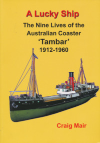
Book, Nautical Association of Australia Inc, A Lucky Ship – Nine Lives of Australian Coaster Tambar 1912-1960, 2013
... Navigation Company, Tambar worked as a lifeline to isolated river and island communities, first in New South Wales, then for the Tasmanian Government and Holymans in Bass Strait (King Island) and as the last steamer serving the Gippsland Lakes. In between she even spent a few years in Papua New Guinea. When World War II broke out, Tambar was commissioned into the RAN as an auxiliary minesweeper, but after the terrible Darwin air raid in 1942 became the first vessel of the newly formed Salvage Board, later assisting in the search for survivors of the Battle of the Coral Sea. ...This high-quality book is the extraordinary story of an ordinary little ship that had a long and eventful life. Perhaps few Australian coasters have had a more interesting and varied history. Built in Scotland in 1912 for the North Coast Steam Navigation Company, Tambar worked as a lifeline to isolated river and island communities, first in New South Wales, then for the Tasmanian Government and Holymans in Bass Strait (King Island) and as the last steamer serving the Gippsland Lakes. In between she even spent a few years in Papua New Guinea. When World War II broke out, Tambar was commissioned into the RAN as an auxiliary minesweeper, but after the terrible Darwin air raid in 1942 became the first vessel of the newly formed Salvage Board, later assisting in the search for survivors of the Battle of the Coral Sea. Returning to Bass Strait in 1944 for a few more years, she then spent the 1950s on standby as a salvage vessel in Melbourne, working on Merilyn, Terawhiti, E.J. Fairnie, and River Burnett. Craig Mair grew up in Grangemouth, Scotland where Tambar was built, and became interested after inheriting a builder's model from his father. He has consulted thousands of records, including the ship's logs, tracked down witnesses, and assembled over 100 photographs and maps to give a unique insight into Tambar's story, and coastal Australia in the middle decades of the twentieth century, before roads took over the transport task. Besides many colourful stories of shipwrecks and strandings, strange cargoes, salty characters, exotic places, wartime air raids, and salvage jobs, the book includes a definitive account of the worst Second World War 'friendly fire' incident in Australian waters in Moreton Bay in 1942.250 pages, Appendices, Bibliography and Indices, extensively illustratednon-fictionThis high-quality book is the extraordinary story of an ordinary little ship that had a long and eventful life. Perhaps few Australian coasters have had a more interesting and varied history. Built in Scotland in 1912 for the North Coast Steam Navigation Company, Tambar worked as a lifeline to isolated river and island communities, first in New South Wales, then for the Tasmanian Government and Holymans in Bass Strait (King Island) and as the last steamer serving the Gippsland Lakes. In between she even spent a few years in Papua New Guinea. When World War II broke out, Tambar was commissioned into the RAN as an auxiliary minesweeper, but after the terrible Darwin air raid in 1942 became the first vessel of the newly formed Salvage Board, later assisting in the search for survivors of the Battle of the Coral Sea. Returning to Bass Strait in 1944 for a few more years, she then spent the 1950s on standby as a salvage vessel in Melbourne, working on Merilyn, Terawhiti, E.J. Fairnie, and River Burnett. Craig Mair grew up in Grangemouth, Scotland where Tambar was built, and became interested after inheriting a builder's model from his father. He has consulted thousands of records, including the ship's logs, tracked down witnesses, and assembled over 100 photographs and maps to give a unique insight into Tambar's story, and coastal Australia in the middle decades of the twentieth century, before roads took over the transport task. Besides many colourful stories of shipwrecks and strandings, strange cargoes, salty characters, exotic places, wartime air raids, and salvage jobs, the book includes a definitive account of the worst Second World War 'friendly fire' incident in Australian waters in Moreton Bay in 1942.naa, australian national line, interest group, moreton bay, tambar, coaster, ships -
 Mission to Seafarers Victoria
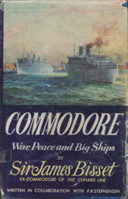
Book, Sir James Bisset, Commodore War, Peace and Big Ships, 1961
... Howard's passion was anything related to the sea, navigational, sea scouts and war conflicts. ...470 pages, black and white photographsnon-fictionjames bisset, ww2, howard timbury, first fleet fellowship victoria, interest group -
 Mission to Seafarers Victoria
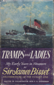
Book, Sir James Bisset, Tramps and Ladies, My Early Years in Steamers by Sir James Bisset, 1959
... Howard's passion was anything related to the sea, navigational, sea scouts and war conflicts. ...315 pages, black and white photographs, dust jacket with book cover.non-fictionjames bisset, ww2, howard timbury, first fleet fellowship victoria, interest group -
 Mission to Seafarers Victoria
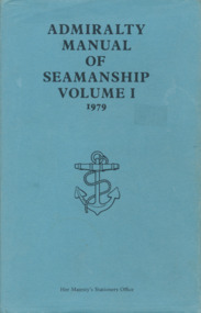
Book, Her Majesty's Stationery Office, Admiralty Manual of Navigation Vol.1 1979, 1979
... Howard's passion was anything related to the sea, navigational, sea scouts and war conflicts. ...509 pages, illustrated , navy linen cover with light blue dust jacket.non-fictionhoward timbury, first fleet fellowship victoria, interest group, education, navigation -
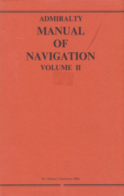 Mission to Seafarers Victoria
Book, Her Majesty's Stationery Office, Admiralty Manual of Navigation Vol.2, 1973
... Howard's passion was anything related to the sea, navigational, sea scouts and war conflicts. ...This volume of the Admiralty Manual of Navigation describes off-shore navigation - the safe conduct of a ship across the open sea where, in general, hearings of objects on land cannot be obtained except by means of radio waves (i.e. using radio fixing aids). The first chapters are mainly concerned with distances, courses, tracks and charts; then various methods of obtaining position lines and positions from astronomical observations are explained, including a rapid. method in the last chapter. The volume also contains an outline of meteorrology and weather forecasting.329 pages, illustrated, navy blue linen cover and red paper dust jacket.non-fictionThis volume of the Admiralty Manual of Navigation describes off-shore navigation - the safe conduct of a ship across the open sea where, in general, hearings of objects on land cannot be obtained except by means of radio waves (i.e. using radio fixing aids). The first chapters are mainly concerned with distances, courses, tracks and charts; then various methods of obtaining position lines and positions from astronomical observations are explained, including a rapid. method in the last chapter. The volume also contains an outline of meteorrology and weather forecasting.howard timbury, first fleet fellowship victoria, interest group, navigation, education -
 Mission to Seafarers Victoria
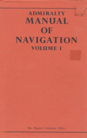
Book, Her Majesty's Stationery Office, Admiralty Manual of Navigation Vol.1, 1977
... Howard's passion was anything related to the sea, navigational, sea scouts and war conflicts. ...This revised edition follows the previous editions in giving a practical guide to navigation and pilotage which, although written primarily for naval officers, will be suitable for all students of navigation. Astronomical navigation and meteorology can be read in Volume II of this manual. The quality of detailed thoroughness that has always distinguished this book is retained, and it has been brought up to date, particularly in the chapters on radio aids to navigation and navigational instruments.544 pages, illustrated, navy blue linen cover and red paper dust jacket.non-fictionThis revised edition follows the previous editions in giving a practical guide to navigation and pilotage which, although written primarily for naval officers, will be suitable for all students of navigation. Astronomical navigation and meteorology can be read in Volume II of this manual. The quality of detailed thoroughness that has always distinguished this book is retained, and it has been brought up to date, particularly in the chapters on radio aids to navigation and navigational instruments.howard timbury, first fleet fellowship victoria, interest group, navigation, education -
 Mission to Seafarers Victoria
Book, Her Majesty's Stationery Office, Admiralty Manual of Navigation Vol.1 1954, 1954
... Howard's passion was anything related to the sea, navigational, sea scouts and war conflicts. ...Volume I is a practical guide for executive officers covering the syllabus laid down for examination in navigation and pilotage for the rank of Lieutenant, but omitting the study of nautical astronomy and meteorology.536 pages, illustrated, navy glossy paper cover with embossed golden anchor and no dust jacket.non-fictionVolume I is a practical guide for executive officers covering the syllabus laid down for examination in navigation and pilotage for the rank of Lieutenant, but omitting the study of nautical astronomy and meteorology.howard timbury, first fleet fellowship victoria, interest group, navigation, education -
 Mission to Seafarers Victoria
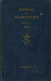
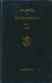
Book, Her Majesty's Stationery Office, Manual of Seamanship Vol.3 1951, 1951
... Howard's passion was anything related to the sea, navigational, sea scouts and war conflicts. ...The Manual of Seamanship is divided into three volumes. Volume III comprises information on the more advanced aspects of seamanship, and is intended as a book of reference for seamen of experience.484 pages, illustrated, navy glossy paper cover with embossed golden anchor and no dust jacket.non-fictionThe Manual of Seamanship is divided into three volumes. Volume III comprises information on the more advanced aspects of seamanship, and is intended as a book of reference for seamen of experience.howard timbury, first fleet fellowship victoria, interest group, navigation, education -
 Mission to Seafarers Victoria
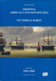
Book, Marten Syme, Shipping Arrivals and Departures, Victorian Ports Volume 3 1856-1860, 1984
... Howard's passion was anything related to the sea, navigational, sea scouts and war conflicts. ..."This book is dedicated to the seamen who supplied the physical link for trade and immigration in the development of the Colony".non-fiction"This book is dedicated to the seamen who supplied the physical link for trade and immigration in the development of the Colony".howard timbury, interest group, navigation, genealogy, family history, ship registers -
 Mission to Seafarers Victoria
Book, Marten Syme, Shipping Arrivals and Departures, Victorian Ports Volume 2 1846-1855, 1984
... Howard's passion was anything related to the sea, navigational, sea scouts and war conflicts. ..."This book is dedicated to the seamen who supplied the physical link for trade and immigration in the development of the Colony".non-fiction"This book is dedicated to the seamen who supplied the physical link for trade and immigration in the development of the Colony". howard timbury, first fleet fellowship victoria, interest group, ship registers, genealogy, family history -
 Mission to Seafarers Victoria
Book, Her Majesty's Stationery Office, Manual of Seamanship Vol.1 1951, 1954
... Howard's passion was anything related to the sea, navigational, sea scouts and war conflicts. ...Volume I is a practical guide for executive officers covering the syllabus laid down for examination in navigation and pilotage for the rank of Lieutenant, but omitting the study of nautical astronomy and meteorology.536 pages, illustrated, navy glossy paper cover with embossed golden anchor and no dust jacket.non-fictionVolume I is a practical guide for executive officers covering the syllabus laid down for examination in navigation and pilotage for the rank of Lieutenant, but omitting the study of nautical astronomy and meteorology.howard timbury, first fleet fellowship victoria, interest group, navigation, education -
 Mission to Seafarers Victoria
Book, Her Majesty's Stationery Office, Manual of Seamanship Vol.2 1951, 1954
... Howard's passion was anything related to the sea, navigational, sea scouts and war conflicts. ...Volume I is a practical guide for executive officers covering the syllabus laid down for examination in navigation and pilotage for the rank of Lieutenant, but omitting the study of nautical astronomy and meteorology.536 pages, illustrated, navy glossy paper cover with embossed golden anchor and no dust jacket.non-fictionVolume I is a practical guide for executive officers covering the syllabus laid down for examination in navigation and pilotage for the rank of Lieutenant, but omitting the study of nautical astronomy and meteorology.howard timbury, first fleet fellowship victoria, interest group, navigation, education -
 Mission to Seafarers Victoria
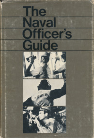
Book, Naval Institute Press, The Naval Officer's Guide, 1970
... Howard's passion was anything related to the sea, navigational, sea scouts and war conflicts. ...509 pages, illustrated , navy linen cover with light blue dust jacket.non-fictionhoward timbury, first fleet fellowship victoria, interest group, education, navigation -
 Mission to Seafarers Victoria
Book, Naval Institute Press, Standard Seamanship for the Merchant navy, 1970
... Howard's passion was anything related to the sea, navigational, sea scouts and war conflicts. ...509 pages, illustrated , navy linen cover with light blue dust jacket.non-fictionhoward timbury, first fleet fellowship victoria, interest group, education, navigation