Showing 65 items matching "sedgwick street"
-
 Marysville & District Historical Society
Document (Item) - Research Document, Rene de Koning, Sedgwick Street Named After Adam Sedgwick (1785 - 1873), 13-08-2022
... Sedgwick Street Named After Adam Sedgwick (1785 - 1873)......sedgwick street...An account of the life of Adam Sedgwick whom Sedgwick Street in Marysville in Victoria is named for....An account of the life of Adam Sedgwick whom Sedgwick Street in Marysville in Victoria is named for....An account of the life of Adam Sedgwick whom Sedgwick Street in Marysville in Victoria is named for. ...An account of the life of Adam Sedgwick whom Sedgwick Street in Marysville in Victoria is named for.An account of the life of Adam Sedgwick whom Sedgwick Street in Marysville in Victoria is named for. Adam Sedgwick was a British geologist and Anglican priest, one of the founders of modern geology. He proposed the Cambrian and Devonian period of the geological timescale. Based on work which he did on Welsh rock strata, he proposed the Cambrian period in 1835, in a joint publication in which Roderick Murchison also proposed the Silurian period. Later in 1840, to resolve what later became known as the Great Devonian Controversy about rocks near the boundary between the Silurian and Carboniferous periods, he and Murchison proposed the Devonian period. adam sedgwick, sedgwick street, marysville, victoria -
 Marysville & District Historical Society
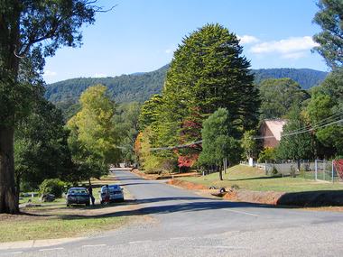
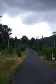
Photograph (Item) - Colour photograph, Travel Victoria, 2004
... sedgwick street...A colour photograph of the view looking down Sedgwick Street towards Lyell Street in Marysville in Victoria....A colour photograph of the view looking down Sedgwick Street towards Lyell Street in Marysville in Victoria....Sedgwick Street, Marysville, Victoria, Australia...A colour photograph of the view looking down Sedgwick Street towards Lyell Street in Marysville in Victoria. sedgwick street lyell street marysville victoria travel victoria photograph A colour photograph of the view looking down Sedgwick Street towards Lyell Street in Marysville in Victoria. ...A colour photograph of the view looking down Sedgwick Street towards Lyell Street in Marysville in Victoria.A colour photograph of the view looking down Sedgwick Street towards Lyell Street in Marysville in Victoria.sedgwick street, lyell street, marysville, victoria, travel victoria, photograph -
 Marysville & District Historical Society
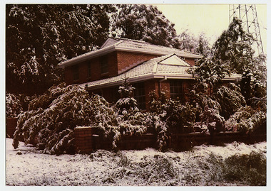
Photograph (Item) - Colour photograph, Unknown
... sedgwick street...A colour photograph of a brick house that was situated in Sedgwick Street in Marysville in Victoria....A colour photograph of a brick house that was situated in Sedgwick Street in Marysville in Victoria. The house and garden are covered in a light dusting of snow....Sedgwick Street, Marysville, Victoria, Australia...Marysville & District Historical Society 39 Darwin Street Marysville yarra-valley-and-the-dandenong-ranges A colour photograph of a brick house that was situated in Sedgwick Street in Marysville in Victoria. A colour photograph of a brick house that was situated in Sedgwick Street in Marysville in Victoria. ...A colour photograph of a brick house that was situated in Sedgwick Street in Marysville in Victoria.A colour photograph of a brick house that was situated in Sedgwick Street in Marysville in Victoria. This house, along with most of the buildings in Marysville, was destroyed in the 2009 Black Saturday bushfires.sedgwick street, marysville, victoria, 2009 black saturday bushfires, photograph -
 Marysville & District Historical Society
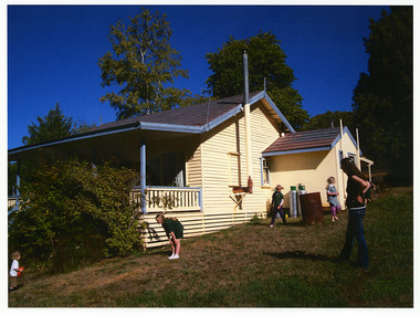
Photograph (Item) - Colour photograph, Unknown
... sedgwick street...A colour photograph of a cream weatherboard house that was situated in Sedgwick Street in Marysville in Victoria....A colour photograph of a cream weatherboard house that was situated in Sedgwick Street in Marysville in Victoria. Shows a lady and four children standing outside the house....Sedgwick Street, Marysville, Victoria, Australia...Marysville & District Historical Society 39 Darwin Street Marysville yarra-valley-and-the-dandenong-ranges A colour photograph of a cream weatherboard house that was situated in Sedgwick Street in Marysville in Victoria. A colour photograph of a cream weatherboard house that was situated in Sedgwick Street in Marysville in Victoria. ...A colour photograph of a cream weatherboard house that was situated in Sedgwick Street in Marysville in Victoria.A colour photograph of a cream weatherboard house that was situated in Sedgwick Street in Marysville in Victoria. This house, along with most of the other buildings in Marysville, was destroyed in the 2009 Black Saturday bushfires.sedgwick street, marysville, victoria, 2009 black saturday bushfires, photograph -
 Ballarat Heritage Services
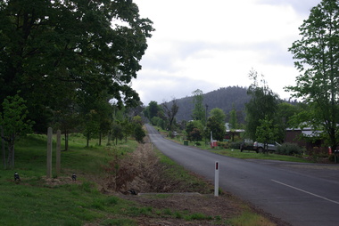
Photograph - Colour, Clare Gervasoni, Sedgwick Street, Marysville, 2014, 02/11/2014
... Sedgwick Street, Marysville, 2014...Sedgwick Street, Marysville, Victoria, Australia...Ballarat Heritage Services PO Box 2209 Bakery Hill Post Office goldfields bushfire black saturday marysville Four colour photographs of Pack Street, Marysville, after the 2009 'Black Saturday' bushfire. Sedgwick Street, Marysville, 2014 Photograph - Colour Clare Gervasoni ...Four colour photographs of Pack Street, Marysville, after the 2009 'Black Saturday' bushfire. bushfire, black saturday, marysville -
 Ballarat Heritage Services
Photograph - Colour, Clare Gervasoni, Sedgwick Street, Marysville, 2012, 15/12/2012
... Sedgwick Street, Marysville, 2012...Sedgwick Street, Marysville, Victoria, Australia...Ballarat Heritage Services PO Box 2209 Bakery Hill Post Office goldfields bushfire black saturday Marysville Four colour photographs of Pack Street, Marysville, after the 2009 'Black Saturday' bushfire. Sedgwick Street, Marysville, 2012 Photograph - Colour Clare Gervasoni ...Four colour photographs of Pack Street, Marysville, after the 2009 'Black Saturday' bushfire. bushfire, black saturday, marysville -
 Marysville & District Historical Society
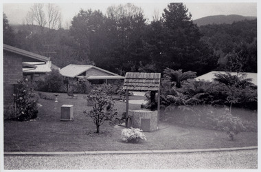
Photograph (Item) - Black and white photograph, Unknown
... Sedgwick Street, Marysville, Victoria, Australia ...A black and white photograph that shows a few of the residential units that were situated in The Village in Marysville in Victoria.A black and white photograph that shows a few of the residential units that were situated in The Village in Marysville in Victoria. This residential village was destroyed in the 2009 Black Saturday bushfires.the village, marysville, victoria, 2009 black saturday bushfires, photograph -
 Marysville & District Historical Society
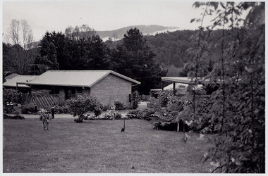
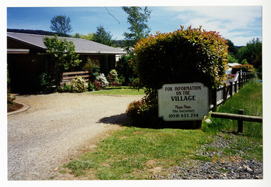
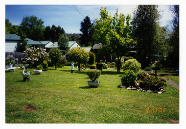
Photograph (Item) - Colour photograph, 1998
... Sedgwick Street, Marysville, Victoria, Australia ...A colour photograph that shows the entrance to The Village in Marysville in Victoria.A colour photograph that shows the entrance to The Village in Marysville in Victoria. This residential village was destroyed in the 2009 Black Saturday bushfires.the village, marysville, victoria, 2009 black saturday bushfires, photograph -
 Marysville & District Historical Society
Photograph (Item) - Colour photograph, 1998
... Sedgwick Street, Marysville, Victoria, Australia ...A colour photograph that shows the gardens at The Village in Marysville in Victoria.A colour photograph that shows the gardens at The Village in Marysville in Victoria. This residential village was destroyed in the 2009 Black Saturday bushfires.the village, marysville, victoria, 2009 black saturday bushfires, photograph -
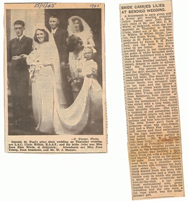
 Bendigo Historical Society Inc.
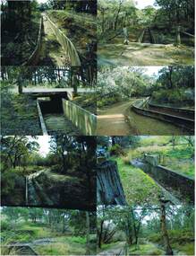
Photograph - COLIBAN MAIN CHANNEL, July,2009
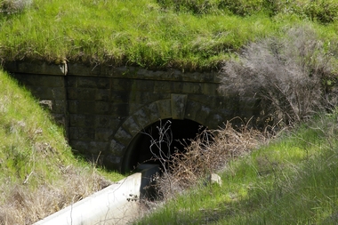
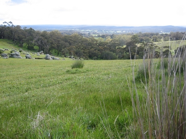
... Street Bendigo goldfields PLACE Water coliban race Coliban Main Channel. Ray Smith and Phil Wilkin - Bendigo Historical Society. Photograph - colour. All photographs are of the Coliban Main Channel. Photo's 1,2,3,4 + 5 = were taken from South Mandurang Road, Spring Road end. Photo's 6,7,8,9,10,11,12 + 13 = were taken top of dirt road section of Springs Road. Photo's 14 + 15 = Taken between Sedgwick ...Photograph - colour. All photographs are of the Coliban Main Channel. Photo's 1,2,3,4 + 5 = were taken from South Mandurang Road, Spring Road end. Photo's 6,7,8,9,10,11,12 + 13 = were taken top of dirt road section of Springs Road. Photo's 14 + 15 = Taken between Sedgwick and North Harcourt, used to be called 'Prestonvale'. Photo No.14 is called Wirths Tunnel, 633 metres in length. Three more sheets of photo's of the Coliban Main Channel, between Sedgwick and Harcourt North. If more info.Ray Smith and Phil Wilkin - Bendigo Historical Society.place, water, coliban race, coliban main channel. -
Bendigo Historical Society Inc.
Map - SEDGWICK, 5/04/1881
... History House 11 Mackenzie Street Bendigo goldfields MAP Bendigo parish plan Sedgwick Map: Parish of Sedgwick, County of Bendigo. ...Map: Parish of Sedgwick, County of Bendigo. Parish plan (number 312 in map cupboard 1)map, bendigo, parish plan, sedgwick -
 The Beechworth Burke Museum
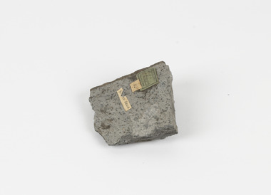
Geological specimen - Spotted Slate, Unknown
... The Beechworth Burke Museum Loch Street Beechworth high-country This specimen was recovered from Sedgwick, VIC. ...This specimen was recovered from Sedgwick, VIC. Spotted slate is a fine-grained porphyroblastic metamorphic rock with a number of compounds including muscovite, quartz, graphite with cordierite poikiloblasts and more. The cordierite poikiloblasts are rounded crystals that size up to 2.5 mm. the growth of these crystals is in response to metamorphism of low to medium intensity. The town Sedgwick was named after British geologist Adam Sedgwick This specimen is part of a larger collection of geological and mineral specimens collected from around Australia (and some parts of the world) and donated to the Burke Museum between 1868-1880. A large percentage of these specimens were collected in Victoria as part of the Geological Survey of Victoria that begun in 1852 (in response to the Gold Rush) to study and map the geology of Victoria. Collecting geological specimens was an important part of mapping and understanding the scientific makeup of the earth. Many of these specimens were sent to research and collecting organisations across Australia, including the Burke Museum, to educate and encourage further study.A solid rectangular hand-sized spotted slate specimen in a shade of light grey with darker flecks throughout Spotted Slate / Locality: Sedgwick Victoria | This is an early specimen / from the Quarter sheet / map. See sample 62 / page 18. Described as 'Spotted Slate' but these / days we would call it spotted hornfels / C. William 15/4/21 slate, spotted slate, victoria, beechworth, burke museum, geological specimen, mineralogy, sedgwick, sedgwick victoria, spotted slate specimen -
 Bendigo Historical Society Inc.
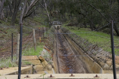
Photograph - Historical Society Field Trip to the Springs at Sedgwick, Abt 2009
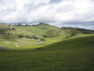
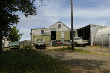
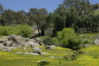
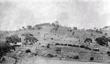
... Street Bendigo goldfields The Phil Wilkin Collection contains a series of 11 Items. The related items can be found by clicking on the reference link below. The following history of the Young family and their descendants who lived at the Springs is provided by Phil Wilkin. His Great Grandparents were Frances Young and August Wirth. Phil has also provided notes on the Wilkin Family and some history of the gold mining in Sedgwick ...The Phil Wilkin Collection contains a series of 11 Items. The related items can be found by clicking on the reference link below. The following history of the Young family and their descendants who lived at the Springs is provided by Phil Wilkin. His Great Grandparents were Frances Young and August Wirth. Phil has also provided notes on the Wilkin Family and some history of the gold mining in Sedgwick. Frances Young's parents Joseph and Margaret Young owned the property called "The Old Place, Preston Vale or Wellington Flat" at Sedgwick near the Springs. Joseph Young owned and Managed the Standard Brewery which was located at Campbells Creek during the late 1800’s early 1900’s. Joseph and Margaret are buried in the Harcourt cemetery. In 1880 August Wirth lived at Mosquito Creek (Lake Eppalock, Victoria) when he married Frances Young. In 1902 they moved to part of Joseph Young's property. They milked cows and sold cattle for a living. One of their children Charles Wirth (Phil Wilkin's Grandfather) bought the land in 1935 after his parents had died. Charles Wirth was a councillor and also was president of the Shire of Strathfieldsaye. The "Old Place" was part of the property owned by members of the family. The old house at the Springs was burnt out by bushfire in January 1944 and much of the stonework was later vandalized by campers. The original Coliban Water Works were designed in 1863 by the Irish engineer Joseph Brady. The system included 70 kilometres of open water channels, aqueducts, syphons and tunnels to carry water (by gravity) from the Coliban River at Malmsbury, north to Castlemaine and Bendigo. Sedgwick is a locality in Central Victoria, Australia. It is located in the City of Greater Bendigo. Facilities include a public hall that opened in 1958 and CFA Rural fire station. It was named Upper Emu Creek until 1901 when it was renamed as Sedgwick after British geologist Adam Sedgwick.Twenty nine photos taken on a field trip by the Bendigo Historical Society to "The Springs" on the main Coliban water channel from Malmsbury to the Sandhurst Reservoir in Bendigo. The water race descends through a concrete chute, and continues sharply around the contour of the hills. Once it descended into a syphon across the gully. The are 182 photos in this series and can be found at 8683.1 to 8683.11. The series also includes photos of the surrounding farming land and the remains of an old house. There are also some notes on the pioneers of the district.history, bendigo, coliban water, joseph brady, irrigation, the springs, sedgwick -
 Bendigo Historical Society Inc.
Photograph - Historical Society Field Trip to the Springs at Sedgwick, Abt 2009
... Street Bendigo goldfields The Phil Wilkin Collection contains a series of 11 Items. The related items can be found by clicking on the reference link below. The following history of the Young family and their descendants who lived at the Springs is provided by Phil Wilkin. His Great Grandparents were Frances Young and August Wirth. Phil has also provided notes on the Wilkin Family and some history of the gold mining in Sedgwick ...The Phil Wilkin Collection contains a series of 11 Items. The related items can be found by clicking on the reference link below. The following history of the Young family and their descendants who lived at the Springs is provided by Phil Wilkin. His Great Grandparents were Frances Young and August Wirth. Phil has also provided notes on the Wilkin Family and some history of the gold mining in Sedgwick. Frances Young's parents Joseph and Margaret Young owned the property called "The Old Place, Preston Vale or Wellington Flat" at Sedgwick near the Springs. Joseph Young owned and Managed the Standard Brewery which was located at Campbells Creek during the late 1800’s early 1900’s. Joseph and Margaret are buried in the Harcourt cemetery. In 1880 August Wirth lived at Mosquito Creek (Lake Eppalock, Victoria) when he married Frances Young. In 1902 they moved to part of Joseph Young's property. They milked cows and sold cattle for a living. One of their children Charles Wirth (Phil Wilkin's Grandfather) bought the land in 1935 after his parents had died. Charles Wirth was a councillor and also was president of the Shire of Strathfieldsaye. The "Old Place" was part of the property owned by members of the family. The old house at the Springs was burnt out by bushfire in January 1944 and much of the stonework was later vandalized by campers. The original Coliban Water Works were designed in 1863 by the Irish engineer Joseph Brady. The system included 70 kilometres of open water channels, aqueducts, syphons and tunnels to carry water (by gravity) from the Coliban River at Malmsbury, north to Castlemaine and Bendigo. Sedgwick is a locality in Central Victoria, Australia. It is located in the City of Greater Bendigo. Facilities include a public hall that opened in 1958 and CFA Rural fire station. It was named Upper Emu Creek until 1901 when it was renamed as Sedgwick after British geologist Adam Sedgwick.Twenty five photos taken on a field trip by the Bendigo Historical Society to "The Springs" on the main Coliban water channel from Malmsbury to the Sandhurst Reservoir in Bendigo. The water race descends through a concrete chute, and continues sharply around the contour of the hills. Once it descended into a syphon across the gully. The are 182 photos in this series and can be found at 8683.1 to 8683.11. The series also includes photos of the surrounding farming land and the remains of an old house. There are also some notes on the pioneers of the district.history, bendigo, coliban water, joseph brady, irrigation, the springs, sedgwick -
 Bendigo Historical Society Inc.
Photograph - Historical Society Field Trip to the Springs at Sedgwick, Abt 2009
... Street Bendigo goldfields The Phil Wilkin Collection contains a series of 11 Items. The related items can be found by clicking on the reference link below. The following history of the Young family and their descendants who lived at the Springs is provided by Phil Wilkin. His Great Grandparents were Frances Young and August Wirth. Phil has also provided notes on the Wilkin Family and some history of the gold mining in Sedgwick ...The Phil Wilkin Collection contains a series of 11 Items. The related items can be found by clicking on the reference link below. The following history of the Young family and their descendants who lived at the Springs is provided by Phil Wilkin. His Great Grandparents were Frances Young and August Wirth. Phil has also provided notes on the Wilkin Family and some history of the gold mining in Sedgwick. Frances Young's parents Joseph and Margaret Young owned the property called "The Old Place, Preston Vale or Wellington Flat" at Sedgwick near the Springs. Joseph Young owned and Managed the Standard Brewery which was located at Campbells Creek during the late 1800’s early 1900’s. Joseph and Margaret are buried in the Harcourt cemetery. In 1880 August Wirth lived at Mosquito Creek (Lake Eppalock, Victoria) when he married Frances Young. In 1902 they moved to part of Joseph Young's property. They milked cows and sold cattle for a living. One of their children Charles Wirth (Phil Wilkin's Grandfather) bought the land in 1935 after his parents had died. Charles Wirth was a councillor and also was president of the Shire of Strathfieldsaye. The "Old Place" was part of the property owned by members of the family. The old house at the Springs was burnt out by bushfire in January 1944 and much of the stonework was later vandalized by campers. The original Coliban Water Works were designed in 1863 by the Irish engineer Joseph Brady. The system included 70 kilometres of open water channels, aqueducts, syphons and tunnels to carry water (by gravity) from the Coliban River at Malmsbury, north to Castlemaine and Bendigo. Sedgwick is a locality in Central Victoria, Australia. It is located in the City of Greater Bendigo. Facilities include a public hall that opened in 1958 and CFA Rural fire station. It was named Upper Emu Creek until 1901 when it was renamed as Sedgwick after British geologist Adam Sedgwick.Twenty six photos taken on a field trip by the Bendigo Historical Society to "The Springs" on the main Coliban water channel from Malmsbury to the Sandhurst Reservoir in Bendigo. The water race descends through a concrete chute, and continues sharply around the contour of the hills. Once it descended into a syphon across the gully. The are 182 photos in this series and can be found at 8683.1 to 8683.11. The series also includes photos of the surrounding farming land and the remains of an old house. There are also some notes on the pioneers of the district.history, bendigo, coliban water, joseph brady, irrigation, the springs, sedgwick -
 Bendigo Historical Society Inc.
Photograph - Historical Society Field Trip to the Springs at Sedgwick, Abt 2009
... Street Bendigo goldfields The Phil Wilkin Collection contains a series of 11 Items. The related items can be found by clicking on the reference link below. The following history of the Young family and their descendants who lived at the Springs is provided by Phil Wilkin. His Great Grandparents were Frances Young and August Wirth. Phil has also provided notes on the Wilkin Family and some history of the gold mining in Sedgwick ...The Phil Wilkin Collection contains a series of 11 Items. The related items can be found by clicking on the reference link below. The following history of the Young family and their descendants who lived at the Springs is provided by Phil Wilkin. His Great Grandparents were Frances Young and August Wirth. Phil has also provided notes on the Wilkin Family and some history of the gold mining in Sedgwick. Frances Young's parents Joseph and Margaret Young owned the property called "The Old Place, Preston Vale or Wellington Flat" at Sedgwick near the Springs. Joseph Young owned and Managed the Standard Brewery which was located at Campbells Creek during the late 1800’s early 1900’s. Joseph and Margaret are buried in the Harcourt cemetery. In 1880 August Wirth lived at Mosquito Creek (Lake Eppalock, Victoria) when he married Frances Young. In 1902 they moved to part of Joseph Young's property. They milked cows and sold cattle for a living. One of their children Charles Wirth (Phil Wilkin's Grandfather) bought the land in 1935 after his parents had died. Charles Wirth was a councillor and also was president of the Shire of Strathfieldsaye. The "Old Place" was part of the property owned by members of the family. The old house at the Springs was burnt out by bushfire in January 1944 and much of the stonework was later vandalized by campers. The original Coliban Water Works were designed in 1863 by the Irish engineer Joseph Brady. The system included 70 kilometres of open water channels, aqueducts, syphons and tunnels to carry water (by gravity) from the Coliban River at Malmsbury, north to Castlemaine and Bendigo. Sedgwick is a locality in Central Victoria, Australia. It is located in the City of Greater Bendigo. Facilities include a public hall that opened in 1958 and CFA Rural fire station. It was named Upper Emu Creek until 1901 when it was renamed as Sedgwick after British geologist Adam Sedgwick.Twenty five photos taken on a field trip by the Bendigo Historical Society to "The Springs" on the main Coliban water channel from Malmsbury to the Sandhurst Reservoir in Bendigo. The water race descends through a concrete chute, and continues sharply around the contour of the hills. Once it descended into a syphon across the gully. The are 182 photos in this series and can be found at 8683.1 to 8683.11. The series also includes photos of the surrounding farming land and the remains of an old house. There are also some notes on the pioneers of the district.history, bendigo, coliban water, joseph brady, irrigation, the springs, sedgwick -
 Bendigo Historical Society Inc.
Photograph - The Young and Wirth Families at Preston Vale, near the Springs Sedgwick, 1880s-1900s
... Street Bendigo goldfields The Phil Wilkin Collection contains a series of 11 Items. The related items can be found by clicking on the reference link below. The following history of the Young family and their descendants who lived at the Springs is provided by Phil Wilkin. His Great Grandparents were Frances Young and August Wirth. Phil has also provided notes on the Wilkin Family and some history of the gold mining in Sedgwick ...The Phil Wilkin Collection contains a series of 11 Items. The related items can be found by clicking on the reference link below. The following history of the Young family and their descendants who lived at the Springs is provided by Phil Wilkin. His Great Grandparents were Frances Young and August Wirth. Phil has also provided notes on the Wilkin Family and some history of the gold mining in Sedgwick. Frances Young's parents Joseph and Margaret Young owned the property called "The Old Place, Preston Vale or Wellington Flat" at Sedgwick near the Springs. Joseph Young owned and Managed the Standard Brewery which was located at Campbells Creek during the late 1800’s early 1900’s. Joseph and Margaret are buried in the Harcourt cemetery. In 1880 August Wirth lived at Mosquito Creek (Lake Eppalock, Victoria) when he married Frances Young. In 1902 they moved to part of Joseph Young's property. They milked cows and sold cattle for a living. One of their children Charles Wirth (Phil Wilkin's Grandfather) bought the land in 1935 after his parents had died. Charles Wirth was a councillor and also was president of the Shire of Strathfieldsaye. The "Old Place" was part of the property owned by members of the family. The old house at the Springs was burnt out by bushfire in January 1944 and much of the stonework was later vandalized by campers. The original Coliban Water Works were designed in 1863 by the Irish engineer Joseph Brady. The system included 70 kilometres of open water channels, aqueducts, syphons and tunnels to carry water (by gravity) from the Coliban River at Malmsbury, north to Castlemaine and Bendigo. Sedgwick is a locality in Central Victoria, Australia. It is located in the City of Greater Bendigo. Facilities include a public hall that opened in 1958 and CFA Rural fire station. It was named Upper Emu Creek until 1901 when it was renamed as Sedgwick after British geologist Adam Sedgwick.Thirty Four Photos of Joseph Young's property near "The Springs" on the main Coliban water channel from Malmsbury to the Sandhurst Reservoir in Bendigo. This item contains family history of Joeph's descendant Charles Wirth, who was a councillor for the Shire of Strathfieldsaye. The water race descends through a concrete chute, and continues sharply around the contour of the hills. Once it descended into a syphon across the gully. The are 182 photos in this series and can be found at 8683.1 to 8683.11. The series also includes photos of the surrounding farming land and the remains of an old house. There are also some notes on the pioneers of the district.history, bendigo, coliban water, joseph brady, irrigation, the springs, sedgwick, charles wirth, preston vale, joseph and margaret young, standard brewery campbells creek harcourt, phil wilkin collection -
Bendigo Historical Society Inc.
Photograph - Phil Wilkin Collection - The Springs at Sedgwick 11 Items
... Street Bendigo goldfields The Phil Wilkin Collection contains a series of 11 Items. The related items can be found by clicking on the reference link below. The following history of the Young family and their descendants who lived at the Springs is provided by Phil Wilkin. His Great Grandparents were Frances Young and August Wirth. Phil has also provided notes on the Wilkin Family and some history of the gold mining in Sedgwick ...The Phil Wilkin Collection contains a series of 11 Items. The related items can be found by clicking on the reference link below. The following history of the Young family and their descendants who lived at the Springs is provided by Phil Wilkin. His Great Grandparents were Frances Young and August Wirth. Phil has also provided notes on the Wilkin Family and some history of the gold mining in Sedgwick. Frances Young's parents Joseph and Margaret Young owned the property called "The Old Place, Preston Vale or Wellington Flat" at Sedgwick near the Springs. Joseph Young owned and Managed the Standard Brewery which was located at Campbells Creek during the late 1800’s early 1900’s. Joseph and Margaret are buried in the Harcourt cemetery. In 1880 August Wirth lived at Mosquito Creek (Lake Eppalock, Victoria) when he married Frances Young. In 1902 they moved to part of Joseph Young's property. They milked cows and sold cattle for a living. One of their children Charles Wirth (Phil Wilkin's Grandfather) bought the land in 1935 after his parents had died. Charles Wirth was a councillor and also was president of the Shire of Strathfieldsaye. The "Old Place" was part of the property owned by members of the family. The old house at the Springs was burnt out by bushfire in January 1944 and much of the stonework was later vandalized by campers. The original Coliban Water Works were designed in 1863 by the Irish engineer Joseph Brady. The system included 70 kilometres of open water channels, aqueducts, syphons and tunnels to carry water (by gravity) from the Coliban River at Malmsbury, north to Castlemaine and Bendigo. Sedgwick is a locality in Central Victoria, Australia. It is located in the City of Greater Bendigo. Facilities include a public hall that opened in 1958 and CFA Rural fire station. It was named Upper Emu Creek until 1901 when it was renamed as Sedgwick after British geologist Adam Sedgwick.The Phil Wilkin Collection contains a series of eleven Items about the Young family and their descendants who lived at the Springs and is provided by Phil Wilkin. His Great Grandparents were Frances Young and August Wirth. Phil has also provided notes on the Wilkin Family and some history of the gold mining in Sedgwick. The are 182 photos in this series and can be found at 8683.1 to 8683.11. The series also includes photos of the surrounding farming land and the remains of an old house. There are also some notes on the pioneers of the district. On DVDhistory, bendigo, coliban water, joseph brady, irrigation, the springs, sedgwick -
 Bendigo Historical Society Inc.
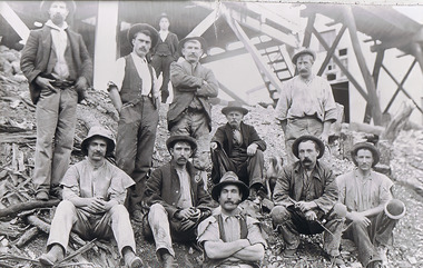
Photograph - The Sedgwick Gold Mine, abt 1909
... Street Bendigo goldfields The Phil Wilkin Collection contains a series of 11 Items. The related items can be found by clicking on the reference link below. The following history of the Young family and their descendants who lived at the Springs is provided by Phil Wilkin. His Great Grandparents were Frances Young and August Wirth. Phil has also provided notes on the Wilkin Family and some history of the gold mining in Sedgwick ...The Phil Wilkin Collection contains a series of 11 Items. The related items can be found by clicking on the reference link below. The following history of the Young family and their descendants who lived at the Springs is provided by Phil Wilkin. His Great Grandparents were Frances Young and August Wirth. Phil has also provided notes on the Wilkin Family and some history of the gold mining in Sedgwick. Frances Young's parents Joseph and Margaret Young owned the property called "The Old Place, Preston Vale or Wellington Flat" at Sedgwick near the Springs. Joseph Young owned and Managed the Standard Brewery which was located at Campbells Creek during the slate 1800’s early 1900’s. Joseph and Margaret are buried in the Harcourt cemetery. In 1880 August Wirth lived at Mosquito Creek (Lake Eppalock, Victoria) when he married Frances Young. In 1902 they moved to part of Joseph Young's property. They milked cows and sold cattle for a living. One of their children Charles Wirth (Phil Wilkin's Grandfather) bought the land in 1935 after his parents had died. Charles Wirth was a councillor and also was president of the Shire of Strathfieldsaye. The "Old Place" was part of the property owned by members of the family. The old house at the Springs was burnt out by bushfire in January 1944 and much of the stonework was later vandalized by campers. The original Coliban Water Works were designed in 1863 by the Irish engineer Joseph Brady. The system included 70 kilometres of open water channels, aqueducts, syphons and tunnels to carry water (by gravity) from the Coliban River at Malmsbury, north to Castlemaine and Bendigo. Sedgwick is a locality in Central Victoria, Australia. It is located in the City of Greater Bendigo. Facilities include a public hall that opened in 1958 and CFA Rural fire station. It was named Upper Emu Creek until 1901 when it was renamed as Sedgwick after British geologist Adam Sedgwick.Four photos of the miners and information on the Sedgwick Gold Mine. There are 182 photos in this series and can be found at 8683.1 to 8683.11. The series also includes photos of the surrounding farming land and the remains of an old house. There are also some notes on the pioneers of the district.history, bendigo, coliban water, joseph brady, irrigation, the springs, sedgwick, phil wilkin collection, sedgwick gold mine -
 Bendigo Historical Society Inc.
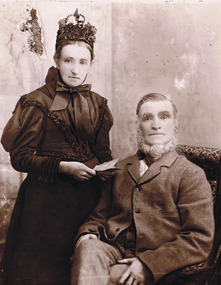
Photograph - Joseph and Margaret Young from Preston Vale (near The Springs) Sedgwick, 1800s-1900s
... Street Bendigo goldfields The Phil Wilkin Collection contains a series of 11 Items. The related items can be found by clicking on the reference link below. The following history of the Young family and their descendants who lived at the Springs is provided by Phil Wilkin. His Great Grandparents were Frances Young and August Wirth. Phil has also provided notes on the Wilkin Family and some history of the gold mining in Sedgwick ...The Phil Wilkin Collection contains a series of 11 Items. The related items can be found by clicking on the reference link below. The following history of the Young family and their descendants who lived at the Springs is provided by Phil Wilkin. His Great Grandparents were Frances Young and August Wirth. Phil has also provided notes on the Wilkin Family and some history of the gold mining in Sedgwick. Frances Young's parents Joseph and Margaret Young owned the property called "The Old Place, Preston Vale or Wellington Flat" at Sedgwick near the Springs. Joseph Young owned and Managed the Standard Brewery which was located at Campbells Creek during the late 1800’s early 1900’s. Joseph and Margaret are buried in the Harcourt cemetery. In 1880 August Wirth lived at Mosquito Creek (Lake Eppalock, Victoria) when he married Frances Young. In 1902 they moved to part of Joseph Young's property. They milked cows and sold cattle for a living. One of their children Charles Wirth (Phil Wilkin's Grandfather) bought the land in 1935 after his parents had died. Charles Wirth was a councillor and also was president of the Shire of Strathfieldsaye. The "Old Place" was part of the property owned by members of the family. The old house at the Springs was burnt out by bushfire in January 1944 and much of the stonework was later vandalized by campers. The original Coliban Water Works were designed in 1863 by the Irish engineer Joseph Brady. The system included 70 kilometres of open water channels, aqueducts, syphons and tunnels to carry water (by gravity) from the Coliban River at Malmsbury, north to Castlemaine and Bendigo. Sedgwick is a locality in Central Victoria, Australia. It is located in the City of Greater Bendigo. Facilities include a public hall that opened in 1958 and CFA Rural fire station. It was named Upper Emu Creek until 1901 when it was renamed as Sedgwick after British geologist Adam Sedgwick.12 photos and historical document of Joseph and Margaret Young. There are 182 photos in this series and can be found at 8683.1 to 8683.11. The series also includes photos of the surrounding farming land and the remains of an old house. There are also some notes on the pioneers of the district.history, bendigo, coliban water, joseph brady, irrigation, the springs, sedgwick, phil wilkin collection, standard brewery campbells creek, joeseph and margaret young -
 Bendigo Historical Society Inc.
Photograph - The Wilkin Family of Sedgwick, 1800s-1900s
... Street Bendigo goldfields The Phil Wilkin Collection contains a series of 11 Items. The related items can be found by clicking on the reference link below. The following history of the Young family and their descendants who lived at the Springs is provided by Phil Wilkin. His Great Grandparents were Frances Young and August Wirth. Phil has also provided notes on the Wilkin Family and some history of the gold mining in Sedgwick ...The Phil Wilkin Collection contains a series of 11 Items. The related items can be found by clicking on the reference link below. The following history of the Young family and their descendants who lived at the Springs is provided by Phil Wilkin. His Great Grandparents were Frances Young and August Wirth. Phil has also provided notes on the Wilkin Family and some history of the gold mining in Sedgwick. Frances Young's parents Joseph and Margaret Young owned the property called "The Old Place, Preston Vale or Wellington Flat" at Sedgwick near the Springs. Joseph Young owned and Managed the Standard Brewery which was located at Campbells Creek during the late 1800’s early 1900’s. Joseph and Margaret are buried in the Harcourt cemetery. In 1880 August Wirth lived at Mosquito Creek (Lake Eppalock, Victoria) when he married Frances Young. In 1902 they moved to part of Joseph Young's property. They milked cows and sold cattle for a living. One of their children Charles Wirth (Phil Wilkin's Grandfather) bought the land in 1935 after his parents had died. Charles Wirth was a councillor and also was president of the Shire of Strathfieldsaye. The "Old Place" was part of the property owned by members of the family. The old house at the Springs was burnt out by bushfire in January 1944 and much of the stonework was later vandalized by campers. The original Coliban Water Works were designed in 1863 by the Irish engineer Joseph Brady. The system included 70 kilometres of open water channels, aqueducts, syphons and tunnels to carry water (by gravity) from the Coliban River at Malmsbury, north to Castlemaine and Bendigo. Sedgwick is a locality in Central Victoria, Australia. It is located in the City of Greater Bendigo. Facilities include a public hall that opened in 1958 and CFA Rural fire station. It was named Upper Emu Creek until 1901 when it was renamed as Sedgwick after British geologist Adam Sedgwick.17 photos and historical document of the Wilkin Family associated with the Springs near Sedgwick. There are 182 photos in this series and can be found at 8683.1 to 8683.11. The series also includes photos of the surrounding farming land and the remains of an old house. There are also some notes on the pioneers of the district.history, bendigo, coliban water, joseph brady, irrigation, the springs, sedgwick, phil wilkin collection, standard brewery campbells creek, joeseph and margaret young, wilkin family -
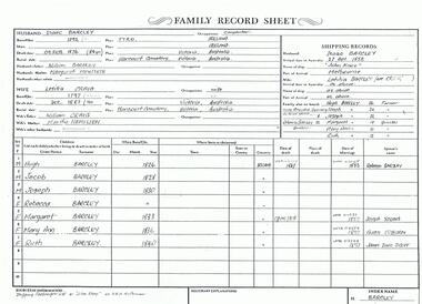 Bendigo Historical Society Inc.
Photograph - The Wilkin Family of Sedgwick - Isaac and Letitia Barcley, 1800s-1900s
... Street Bendigo goldfields The Phil Wilkin Collection contains a series of 11 Items. The related items can be found by clicking on the reference link below. The following history of the Young family and their descendants who lived at the Springs is provided by Phil Wilkin. His Great Grandparents were Frances Young and August Wirth. Phil has also provided notes on the Wilkin Family and some history of the gold mining in Sedgwick ...The Phil Wilkin Collection contains a series of 11 Items. The related items can be found by clicking on the reference link below. The following history of the Young family and their descendants who lived at the Springs is provided by Phil Wilkin. His Great Grandparents were Frances Young and August Wirth. Phil has also provided notes on the Wilkin Family and some history of the gold mining in Sedgwick. Frances Young's parents Joseph and Margaret Young owned the property called "The Old Place, Preston Vale or Wellington Flat" at Sedgwick near the Springs. Joseph Young owned and Managed the Standard Brewery which was located at Campbells Creek during the late 1800’s early 1900’s. Joseph and Margaret are buried in the Harcourt cemetery. In 1880 August Wirth lived at Mosquito Creek (Lake Eppalock, Victoria) when he married Frances Young. In 1902 they moved to part of Joseph Young's property. They milked cows and sold cattle for a living. One of their children Charles Wirth (Phil Wilkin's Grandfather) bought the land in 1935 after his parents had died. Charles Wirth was a councillor and also was president of the Shire of Strathfieldsaye. The "Old Place" was part of the property owned by members of the family. The old house at the Springs was burnt out by bushfire in January 1944 and much of the stonework was later vandalized by campers. The original Coliban Water Works were designed in 1863 by the Irish engineer Joseph Brady. The system included 70 kilometres of open water channels, aqueducts, syphons and tunnels to carry water (by gravity) from the Coliban River at Malmsbury, north to Castlemaine and Bendigo. Sedgwick is a locality in Central Victoria, Australia. It is located in the City of Greater Bendigo. Facilities include a public hall that opened in 1958 and CFA Rural fire station. It was named Upper Emu Creek until 1901 when it was renamed as Sedgwick after British geologist Adam Sedgwick.Seven historical documents of Isacc and Letitia Barcley who were associated with the Wilkin Family and also with the Springs near Sedgwick. There are 182 photos in this series and can be found at 8683.1 to 8683.11. The series also includes photos of the surrounding farming land and the remains of an old house. There are also some notes on the pioneers of the district.history, bendigo, coliban water, joseph brady, irrigation, the springs, sedgwick, phil wilkin collection, joeseph and margaret young, letitia and isacc barclay -
 Bendigo Historical Society Inc.
Photograph - BLACK AND WHITE PHOTOGRAAPH OF GREYHOUND
... History House 11 Mackenzie Street Bendigo goldfields CLUBS AND ASSOCIATIONS Sport Greyhound racing Black and white photograph of greyhound. 3rd shot - Local dog trialling, Brian Rogan - Sedgwick. ...Black and white photograph of greyhound. 3rd shot - Local dog trialling, Brian Rogan - Sedgwick. Dolly.clubs and associations, sport, greyhound racing -
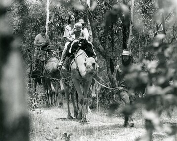 Bendigo Historical Society Inc.
Photograph - SEDGWICK CAMEL FARM
... History House 11 Mackenzie Street Bendigo goldfields AGRICULTURE Farm camel farm Black and white photo of Paul Robinson leads a party of fours on a trek trough bush at Sedgwick camel farm. ...Black and white photo of Paul Robinson leads a party of fours on a trek trough bush at Sedgwick camel farm.agriculture, farm, camel farm -
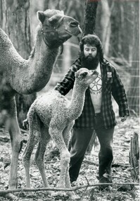 Bendigo Historical Society Inc.
Photograph - SEDGWICK CAMEL FARM
... History House 11 Mackenzie Street Bendigo goldfields AGRICULTURE Farm camel farm Black and white photo of Paul Robinson with a camel calf and a camel at the Sedgwick camel farm. ...Black and white photo of Paul Robinson with a camel calf and a camel at the Sedgwick camel farm.agriculture, farm, camel farm -
 Bendigo Historical Society Inc.
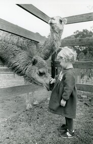
Photograph - SEDGWICK CAMEL FARM
... History House 11 Mackenzie Street Bendigo goldfields AGRICULTURE Farm camel farm Black and white photo of a young girl patting a camel with another camel looking on at Sedgwick camel farm. ...Black and white photo of a young girl patting a camel with another camel looking on at Sedgwick camel farm.agriculture, farm, camel farm -
 Bendigo Historical Society Inc.
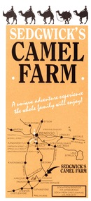
Ephemera - Camel Farm, about 1980s
... History House 11 Mackenzie Street Bendigo goldfields Now called Mattie's Sanctuary, it provides homes for all livestock animals although there is a particular emphasis on excess male camels from the camel dairies of regional Victoria. history bendigo merle lummis collection sedgwick's camel farm epson market Sedgewick Camel Farm and Epsom Market Brochures 1. ...Now called Mattie's Sanctuary, it provides homes for all livestock animals although there is a particular emphasis on excess male camels from the camel dairies of regional Victoria.Sedgewick Camel Farm and Epsom Market Brochures 1. Camel Farm: Advertising Brochure complete with map of location, hours of operation, tours and prices. 2. Epsom Market, times and phone number, location, times of opening and invitation to become a seller. history, bendigo, merle lummis collection, sedgwick's camel farm, epson market