
Showing 6 items matching "sherbrooke falls"
-
 Mt Dandenong & District Historical Society Inc.
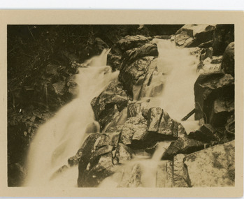
Photograph, Sherbrooke Falls, Sherbrooke, c1913
... Sherbrooke Falls, Sherbrooke......Sherbrooke Falls...On reverse - Sherbrooke Falls, Sherbrooke...Sherbrooke Falls, Sherbrooke Photograph ...This set of 8 photographs was produced by the Rose Stenograph Co. c1913 to be included in photograph albums. The show tourist scenes of Sassafras and surrounds. The photographs were donated by a family in Western Australia whose parents lived in Sassafras c1918.Small b & w photograph from a series of 8 showing scenes from Sassafras produced by the Rose Stenograph Co. c1913.On reverse - Sherbrooke Falls, Sherbrookesherbrooke, sherbrooke falls, sassafras, falls -
 Southern Sherbrooke Historical Society Inc.
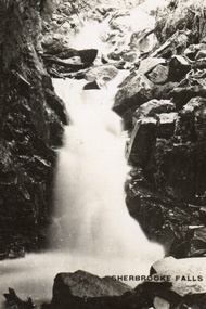
Postcard, Sherbrooke Falls
... Sherbrooke Falls...Sepia-toned postcard featuring Sherbrooke Falls running heavily. Rocks at side of Falls. ...Sherbrooke Falls Postcard ...Sepia-toned postcard featuring Sherbrooke Falls running heavily. Rocks at side of Falls. -
 Southern Sherbrooke Historical Society Inc.
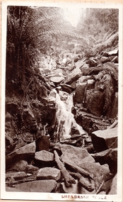
Photograph, Sherbrooke Falls
... Sherbrooke Falls...Photo of the falls in Sherbrooke Forest. Huge amount of large rocks in and around creek bed. ...At the top of the falls a man sits with another person who appears to be a woman. c.1920. Sherbrooke Falls Photograph ...Photo of the falls in Sherbrooke Forest. Huge amount of large rocks in and around creek bed. Ferns grow up sides of banks. Low volume of water indicates dry season. At the top of the falls a man sits with another person who appears to be a woman. c.1920. -
 Southern Sherbrooke Historical Society Inc.
Information folder - Charles Hammond
... ...sherbrooke falls...dandenong ranges bushfires belgrave tecoma puffing billy coles nursery nathania springs sherbrooke falls dandenong reservoir Photocopies of watercolours reproduced in book "Charlie Hammond's Sketchbook", showing scenes in the Dandenong Ranges, early 1900s. ...Photocopies of watercolours reproduced in book "Charlie Hammond's Sketchbook", showing scenes in the Dandenong Ranges, early 1900s. -article, "Library gains a colonial treasure", Age, 17 July 1987, 2 copies, re. acquisition of Hammond sketchbooks by State Library of Victoria -photocopy of first two pages from book, Charles Hammond's Sketch-book.dandenong ranges, bushfires, belgrave, tecoma, puffing billy, coles nursery, nathania springs, sherbrooke falls, dandenong reservoir -
Southern Sherbrooke Historical Society Inc.
Map - photocopy, Woodcock & McCormack, civil engineers & architects & surveyors, The Major Estate, Belgrave
... Arrows to Belgrave, Sherbrooke Falls, Main Rd and store....Arrows to Belgrave, Sherbrooke Falls, Main Rd and store. The Major Estate, Belgrave Map - photocopy Woodcock & McCormack, civil engineers & architects & surveyors ...A photocopy taken from the original land sale map provided to the society through Karel Coxell of Stockdale & Leggo. The original maps are stored in large bound account books and were originally the propert of McNally Real Estate. The books are held (in 22 A3 sheets. Shows The Serpentine between Government Rd (now Sandells Rd) and Government Rd(now Terrys Ave), Belgrave. Arrows to Belgrave, Sherbrooke Falls, Main Rd and store.land sales, advertisement, real estate subdivision, t. mahoney -
 Mont De Lancey
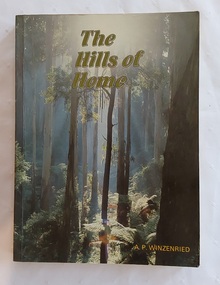
Book, Arthur Paul Wizenreid et al, The Hills of Home: A Bicentennial History of the Shire of Sherbrooke, 1988
... The forest offers popular hiking trails, including the walk to Sherbrooke Falls, and multiple picnic areas like Grants Picnic Ground. ...This 374-page work traces the history of the Shire of Sherbrooke in Victoria, Australia. It covers the region's development from before European colonisation up to the bicentennial year. Sherbrooke Forest is a prominent 800+ hectare section of the Dandenong Ranges National Park, located about 40 km east of Melbourne. Famous for its towering Mountain Ash trees and dense fern gullies, it is a premier location for spotting wild lyrebirds, wallabies, and cockatoos. The forest offers popular hiking trails, including the walk to Sherbrooke Falls, and multiple picnic areas like Grants Picnic Ground.This is a local history of the Shire of Sherbrooke in Victoria, Australia, documenting its development. The cover front has a beautiful green toned scene of the forest trees with the title printed at the top in pale green lettering outlined in black. The author is printed in yellow at the bottom. The title page lists the publishing details with Original pen and ink drawings by Jillienne Winzenried printed at the bottom. There is an Acknowledgements page, Foreword, Contents and Introduction. At the back, Chapter 18 is a Prologue, followed by three Appendices, Endnotes and an Index. Throughout the book are black and white photos as well as coloured ones, maps, illustrations, lists, advertisements. The back cover has a photograph with a black surround depicting a woman seated looking at autumn leaves. Pp. 374 non-fictionThis 374-page work traces the history of the Shire of Sherbrooke in Victoria, Australia. It covers the region's development from before European colonisation up to the bicentennial year. Sherbrooke Forest is a prominent 800+ hectare section of the Dandenong Ranges National Park, located about 40 km east of Melbourne. Famous for its towering Mountain Ash trees and dense fern gullies, it is a premier location for spotting wild lyrebirds, wallabies, and cockatoos. The forest offers popular hiking trails, including the walk to Sherbrooke Falls, and multiple picnic areas like Grants Picnic Ground. australian history, dandenong ranges - history, dandenong ranges - tourism and travel, tourism - victoria, sherbrooke forest - victoria
