Showing 15 items matching "sherwood estate"
-
 Hume City Civic Collection
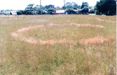
Photograph, early 1990's
... sherwood estate...A coloured photograph of a sacred site featuring an Aboriginal ring within the Sherwood Housing Estate. There is a cleared grassed area with a distinctive ring in the foreground with the housing estate in the background....The former Shire of Bulla published a detailed study of the Aboriginal Ring sites in the early 1990's. sherwood estate aboriginal ring sites george evans collection A coloured photograph of a sacred site featuring an Aboriginal ring within the Sherwood Housing Estate. ...This is one of a series of Aboriginal rings which are found in the Sunbury area. The former Shire of Bulla published a detailed study of the Aboriginal Ring sites in the early 1990's.A coloured photograph of a sacred site featuring an Aboriginal ring within the Sherwood Housing Estate. There is a cleared grassed area with a distinctive ring in the foreground with the housing estate in the background.sherwood estate, aboriginal ring sites, george evans collection -
 Hume City Civic Collection
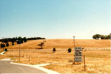
Photograph, c late 1990s
... A view of the Aboriginal ring and sacred site and its close proximity to a proposed housing estate at Sherwood near Racecourse Road....Despite rapid development in the area, those sites are protected heritage sites. aboriginal culture aboriginal rings sacred sites george evans collection A view of the Aboriginal ring and sacred site and its close proximity to a proposed housing estate at Sherwood near Racecourse Road. Photograph ...The series of 9 photographs were taken to be included in a study of archaeological sites and Aboriginal rings in the Sunbury area. Five earth rings which are thought to be associated with male initiation ceremonies have been identified in Sunbury. Only 3 others have been found in the rest of Victoria. Despite rapid development in the area, those sites are protected heritage sites.A view of the Aboriginal ring and sacred site and its close proximity to a proposed housing estate at Sherwood near Racecourse Road.aboriginal culture, aboriginal rings, sacred sites, george evans collection -
 Eltham District Historical Society Inc
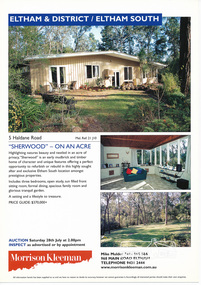
Folder, Sherwood, 5 Haldane Road, Eltham
... estate...mudbrick...haldane road...eltham south...Sherwood...Eltham District Historical Society Inc 728 Main Rd Eltham melbourne Morrison Kleeman Real Estate sales information material gayle blackwood collection houses morrison kleeman real estate mudbrick haldane road eltham south Sherwood 1 document, 2 pages A4 Sherwood, 5 Haldane Road, Eltham Folder ...Morrison Kleeman Real Estate sales information material1 document, 2 pages A4 gayle blackwood collection, houses, morrison kleeman real estate, mudbrick, haldane road, eltham south, sherwood -
 Surrey Hills Historical Society Collection
Folder of real estate advertisements, Folders of real estate advertisements (Streets beginning with S), Various
... Surrey Hills Historical Society Collection 190A Canterbury Road Canterbury melbourne st georges avenue st james avenue salisbury avenue scheele street scottsdale street serpentine street shepherd street shepreth street sherwood road shrimpton court sir garnet road smythe avenue stanhope street streeton court suffolk road sunbury crescent surrey avenue sydenham lane sythney court A4 folders with individual pockets for each property in streets beginning with S located in Surrey Hills and Mont Albert. Folders are ordered by street name and then chronologically by property number. Each property has its own pocket. This may include multiple real estate ...A4 folders with individual pockets for each property in streets beginning with S located in Surrey Hills and Mont Albert. Folders are ordered by street name and then chronologically by property number. Each property has its own pocket. This may include multiple real estate advertisements collected from sales over time. It may also include copies of any research undertaken by Alan Holt and / or members of the SHNCHC team. These are augmented by cards in the Alan Holt index file and by his property registers of Surrey Hills and Mont Albert.st georges avenue, st james avenue, salisbury avenue, scheele street, scottsdale street, serpentine street, shepherd street, shepreth street, sherwood road, shrimpton court, sir garnet road, smythe avenue, stanhope street, streeton court, suffolk road, sunbury crescent, surrey avenue, sydenham lane, sythney court -
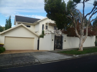
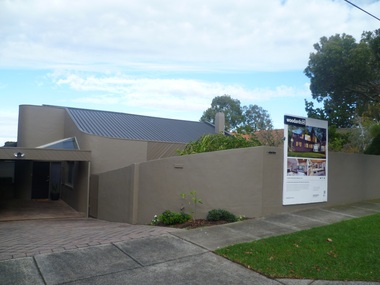
 Surrey Hills Historical Society Collection
Photograph - 1 Sherwood Road, Surrey Hills, On The Street Where You Live Project
... These photos provide a snapshot of real estate in the suburbs of Mont Albert and Surrey Hills during a period of rapid change with many properties on large blocks demolished to create higher density residential development or renewal of single dwellings. At particular risk were properties not covered by heritage overlays, especially interwar housing and post 1950's housing. On The Street Where You Live Project Photograph 1 Sherwood ...Photos documenting this address as part of a photographic series undertaken by volunteer photographers during 2013 and 2014 for The Street Where You Live Project. This was organised through the Surrey Hills Neighbourhood Centre and covered the postcode 3127 in the cities of Boroondara and Whitehorse.These photos provide a snapshot of real estate in the suburbs of Mont Albert and Surrey Hills during a period of rapid change with many properties on large blocks demolished to create higher density residential development or renewal of single dwellings. At particular risk were properties not covered by heritage overlays, especially interwar housing and post 1950's housing. -
 Surrey Hills Historical Society Collection
Photograph - 3 Sherwood Road, Surrey Hills, On The Street Where You Live Project
... These photos provide a snapshot of real estate in the suburbs of Mont Albert and Surrey Hills during a period of rapid change with many properties on large blocks demolished to create higher density residential development or renewal of single dwellings. At particular risk were properties not covered by heritage overlays, especially interwar housing and post 1950's housing. On The Street Where You Live Project Photograph 3 Sherwood ...Photos documenting this address as part of a photographic series undertaken by volunteer photographers during 2013 and 2014 for The Street Where You Live Project. This was organised through the Surrey Hills Neighbourhood Centre and covered the postcode 3127 in the cities of Boroondara and Whitehorse.These photos provide a snapshot of real estate in the suburbs of Mont Albert and Surrey Hills during a period of rapid change with many properties on large blocks demolished to create higher density residential development or renewal of single dwellings. At particular risk were properties not covered by heritage overlays, especially interwar housing and post 1950's housing. -
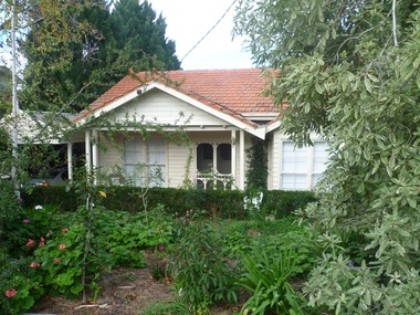
 Surrey Hills Historical Society Collection
Photograph - 5 Sherwood Road, Surrey Hills, On The Street Where You Live Project
... These photos provide a snapshot of real estate in the suburbs of Mont Albert and Surrey Hills during a period of rapid change with many properties on large blocks demolished to create higher density residential development or renewal of single dwellings. At particular risk were properties not covered by heritage overlays, especially interwar housing and post 1950's housing. On The Street Where You Live Project Photograph 5 Sherwood ...Photos documenting this address as part of a photographic series undertaken by volunteer photographers during 2013 and 2014 for The Street Where You Live Project. This was organised through the Surrey Hills Neighbourhood Centre and covered the postcode 3127 in the cities of Boroondara and Whitehorse.These photos provide a snapshot of real estate in the suburbs of Mont Albert and Surrey Hills during a period of rapid change with many properties on large blocks demolished to create higher density residential development or renewal of single dwellings. At particular risk were properties not covered by heritage overlays, especially interwar housing and post 1950's housing. -
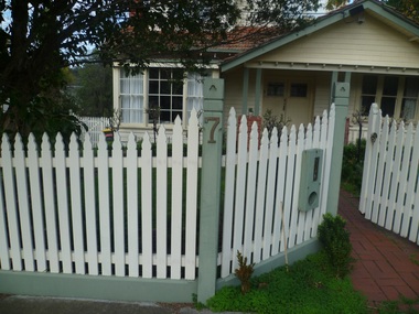 Surrey Hills Historical Society Collection
Photograph - 7 Sherwood Road, Surrey Hills, On The Street Where You Live Project
... These photos provide a snapshot of real estate in the suburbs of Mont Albert and Surrey Hills during a period of rapid change with many properties on large blocks demolished to create higher density residential development or renewal of single dwellings. At particular risk were properties not covered by heritage overlays, especially interwar housing and post 1950's housing. On The Street Where You Live Project Photograph 7 Sherwood ...Photos documenting this address as part of a photographic series undertaken by volunteer photographers during 2013 and 2014 for The Street Where You Live Project. This was organised through the Surrey Hills Neighbourhood Centre and covered the postcode 3127 in the cities of Boroondara and Whitehorse.These photos provide a snapshot of real estate in the suburbs of Mont Albert and Surrey Hills during a period of rapid change with many properties on large blocks demolished to create higher density residential development or renewal of single dwellings. At particular risk were properties not covered by heritage overlays, especially interwar housing and post 1950's housing. -
 Surrey Hills Historical Society Collection
Photograph - 9 Sherwood Road, Surrey Hills, On The Street Where You Live Project
... These photos provide a snapshot of real estate in the suburbs of Mont Albert and Surrey Hills during a period of rapid change with many properties on large blocks demolished to create higher density residential development or renewal of single dwellings. At particular risk were properties not covered by heritage overlays, especially interwar housing and post 1950's housing. On The Street Where You Live Project Photograph 9 Sherwood ...Photos documenting this address as part of a photographic series undertaken by volunteer photographers during 2013 and 2014 for The Street Where You Live Project. This was organised through the Surrey Hills Neighbourhood Centre and covered the postcode 3127 in the cities of Boroondara and Whitehorse.These photos provide a snapshot of real estate in the suburbs of Mont Albert and Surrey Hills during a period of rapid change with many properties on large blocks demolished to create higher density residential development or renewal of single dwellings. At particular risk were properties not covered by heritage overlays, especially interwar housing and post 1950's housing. -
 Surrey Hills Historical Society Collection
Photograph - 11 Sherwood Road, Surrey Hills, On The Street Where You Live Project
... These photos provide a snapshot of real estate in the suburbs of Mont Albert and Surrey Hills during a period of rapid change with many properties on large blocks demolished to create higher density residential development or renewal of single dwellings. At particular risk were properties not covered by heritage overlays, especially interwar housing and post 1950's housing. On The Street Where You Live Project Photograph 11 Sherwood ...Photos documenting this address as part of a photographic series undertaken by volunteer photographers during 2013 and 2014 for The Street Where You Live Project. This was organised through the Surrey Hills Neighbourhood Centre and covered the postcode 3127 in the cities of Boroondara and Whitehorse.These photos provide a snapshot of real estate in the suburbs of Mont Albert and Surrey Hills during a period of rapid change with many properties on large blocks demolished to create higher density residential development or renewal of single dwellings. At particular risk were properties not covered by heritage overlays, especially interwar housing and post 1950's housing. -
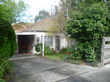 Surrey Hills Historical Society Collection
Photograph - 13 Sherwood Road, Surrey Hills, On The Street Where You Live Project
... These photos provide a snapshot of real estate in the suburbs of Mont Albert and Surrey Hills during a period of rapid change with many properties on large blocks demolished to create higher density residential development or renewal of single dwellings. At particular risk were properties not covered by heritage overlays, especially interwar housing and post 1950's housing. On The Street Where You Live Project Photograph 13 Sherwood ...Photos documenting this address as part of a photographic series undertaken by volunteer photographers during 2013 and 2014 for The Street Where You Live Project. This was organised through the Surrey Hills Neighbourhood Centre and covered the postcode 3127 in the cities of Boroondara and Whitehorse.These photos provide a snapshot of real estate in the suburbs of Mont Albert and Surrey Hills during a period of rapid change with many properties on large blocks demolished to create higher density residential development or renewal of single dwellings. At particular risk were properties not covered by heritage overlays, especially interwar housing and post 1950's housing. -
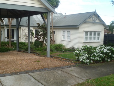
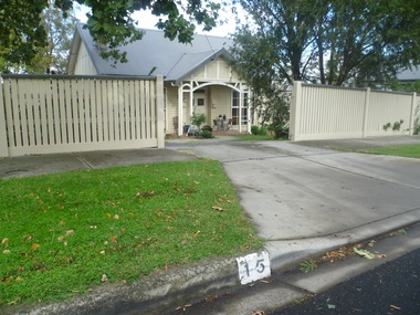 Surrey Hills Historical Society Collection
Photograph - 15 Sherwood Road, Surrey Hills, On The Street Where You Live Project
... These photos provide a snapshot of real estate in the suburbs of Mont Albert and Surrey Hills during a period of rapid change with many properties on large blocks demolished to create higher density residential development or renewal of single dwellings. At particular risk were properties not covered by heritage overlays, especially interwar housing and post 1950's housing. On The Street Where You Live Project Photograph 15 Sherwood ...Photos documenting this address as part of a photographic series undertaken by volunteer photographers during 2013 and 2014 for The Street Where You Live Project. This was organised through the Surrey Hills Neighbourhood Centre and covered the postcode 3127 in the cities of Boroondara and Whitehorse.These photos provide a snapshot of real estate in the suburbs of Mont Albert and Surrey Hills during a period of rapid change with many properties on large blocks demolished to create higher density residential development or renewal of single dwellings. At particular risk were properties not covered by heritage overlays, especially interwar housing and post 1950's housing. -
 Surrey Hills Historical Society Collection
Photograph - 17 Sherwood Road, Surrey Hills, On The Street Where You Live Project
... These photos provide a snapshot of real estate in the suburbs of Mont Albert and Surrey Hills during a period of rapid change with many properties on large blocks demolished to create higher density residential development or renewal of single dwellings. At particular risk were properties not covered by heritage overlays, especially interwar housing and post 1950's housing. On The Street Where You Live Project Photograph 17 Sherwood ...Photos documenting this address as part of a photographic series undertaken by volunteer photographers during 2013 and 2014 for The Street Where You Live Project. This was organised through the Surrey Hills Neighbourhood Centre and covered the postcode 3127 in the cities of Boroondara and Whitehorse.These photos provide a snapshot of real estate in the suburbs of Mont Albert and Surrey Hills during a period of rapid change with many properties on large blocks demolished to create higher density residential development or renewal of single dwellings. At particular risk were properties not covered by heritage overlays, especially interwar housing and post 1950's housing. -
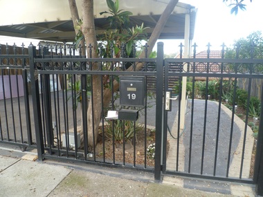 Surrey Hills Historical Society Collection
Photograph - 19 Sherwood Road, Surrey Hills, On The Street Where You Live Project
... These photos provide a snapshot of real estate in the suburbs of Mont Albert and Surrey Hills during a period of rapid change with many properties on large blocks demolished to create higher density residential development or renewal of single dwellings. At particular risk were properties not covered by heritage overlays, especially interwar housing and post 1950's housing. On The Street Where You Live Project Photograph 19 Sherwood ...Photos documenting this address as part of a photographic series undertaken by volunteer photographers during 2013 and 2014 for The Street Where You Live Project. This was organised through the Surrey Hills Neighbourhood Centre and covered the postcode 3127 in the cities of Boroondara and Whitehorse.These photos provide a snapshot of real estate in the suburbs of Mont Albert and Surrey Hills during a period of rapid change with many properties on large blocks demolished to create higher density residential development or renewal of single dwellings. At particular risk were properties not covered by heritage overlays, especially interwar housing and post 1950's housing. -
Canterbury History Group
Drawing - Illustration, Original house names on original Strathcona property, Turnbull, Glen, 1/12/2008
... Estate... "Glen Allen"... "Shalimar"... "Hilary"... "Sherwood...Canterbury Strathcona Baptist Girls Grammar School Scott Street Bryson Street Claremont Crescent Prospect Hill Road Claremont Park Estate "Glen Allen" "Shalimar" "Hilary" "Sherwood" "Marshalton" "ELston" "Whitefoord" "Natrie" A 4 Drawing Illustration, Original house names on original Strathcona property Turnbull, Glen ...Illustration prepared by Glen Turnbull of the original house names on the original Strathcona property. This covers the area bounded by Scott Street, Bryson Street, Claremont Crescent and Prospect Hill Road, Canterbury.A 4canterbury, strathcona baptist girls grammar school, scott street, bryson street, claremont crescent, prospect hill road, claremont park estate, "glen allen", "shalimar", "hilary", "sherwood", "marshalton", "elston", "whitefoord", "natrie"