Showing 1658 items matching "site plan"
-
![Booklet: Historic Aradale [NMIT Site Plan and Introduction 2003], HiBooklet: Historic Aradale [NMIT Site Plan and Introduction 2003]](/media/collectors/4fac93a2023fd71f703efeec/items/50bbef912162ef06b884a6bc/item-media/50bc39322162ef06b884f20b/item-fit-380x285.jpg?cb=6) NMIT (Northern Melbourne Institute of TAFE)
NMIT (Northern Melbourne Institute of TAFE)Booklet: Historic Aradale [NMIT Site Plan and Introduction 2003], HiBooklet: Historic Aradale [NMIT Site Plan and Introduction 2003]
... Booklet: Historic Aradale [NMIT Site Plan and Introduction 2003]...HiBooklet: Historic Aradale [NMIT Site Plan and Introduction 2003]......Aradale Site Plan...Twenty-seven page colour booklet, with introduction and site plans for the Ararat Campus of NMIT, 2003. ...NMIT (Northern Melbourne Institute of TAFE) Aradale NMIT Ararat Aradale Site Plan Program for Official opening 2002 NMIT Twenty-seven page colour booklet, with introduction and site plans for the Ararat Campus of NMIT, 2003. ...Twenty-seven page colour booklet, with introduction and site plans for the Ararat Campus of NMIT, 2003. One large A3 copy and one smaller A4 copy. Also Program for Official opening of Aradale Campus Sunday 17 November 2002. Also large aerial photograph of Aradale campus 2003. Also VHS video Ararat Rural City Council celebrates rebirth of Aradale, Ballarat Win TV State television news 15/3/2002. Bill Braithwaite, Ararat Rural City Council, Peter Ray, NMIT.aradale, nmit ararat, aradale site plan, program for official opening 2002, nmit -
 Emerald Museum & Nobelius Heritage Park
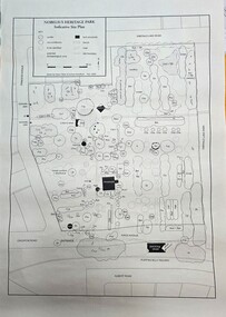
Map - Map of Nobelius Heritage Park - 2003, Nobelius Heritage Park, Indicative Site Plan - drawn November 2003, c2003
... Nobelius Heritage Park, Indicative Site Plan - drawn November 2003...Image of Indicative Site Plan of Nobelius Heritage Park...Nobelius Heritage Park, indicative site plan (Legend)/locations of tress/plants on the site...Emerald Museum & Nobelius Heritage Park 5 Crichton Rd Emerald yarra-valley-and-the-dandenong-ranges Laid out plan of Nobelius Heritage Park dated 2003, showing locations of trees and plants Nobelius Heritage Park, indicative site plan (Legend)/locations of tress/plants on the site Image of Indicative Site Plan of Nobelius Heritage Park Nobelius Heritage Park, Indicative Site Plan - drawn November 2003 Map Map of Nobelius Heritage Park - 2003 ...Laid out plan of Nobelius Heritage Park dated 2003, showing locations of trees and plantsImage of Indicative Site Plan of Nobelius Heritage ParkLaid out plan of Nobelius Heritage Park dated 2003, showing locations of trees and plants -
 Moorabbin Air Museum
Book (Item) - Ansett Sydney Airport Site Plan
... Ansett Sydney Airport Site Plan...Ansett Sydney Airport Site Plan...Moorabbin Air Museum Moorabbin Airport 12 First Street Moorabbin melbourne Ansett Sydney Airport Site Plan Book Ansett Sydney Airport Site Plan ... -
 Federation University Historical Collection
Plan - Site Plan, Mount Helen Campus Academic area
... Site Plan...site plan...Federation University site plan made for the Ballarat College of Advanced Education ...Federation University site plan made for the Ballarat College of Advanced Education site plan federation university ballarat college of advanced education Mount Helen Campus Campus Plan printed with location names and symbols Printed architectural plan of the Mount Helen campus Mount Helen Campus Academic area Plan Site Plan ...Federation University site plan made for the Ballarat College of Advanced Education Printed architectural plan of the Mount Helen campusprinted with location names and symbolssite plan, federation university, ballarat college of advanced education, mount helen campus, campus plan -
 Greensborough Historical Society
Planning Document, Banyule City Council, Site plan of Greensborough 1997, 28/07/1997
... Site plan of Greensborough 1997...Site plans for the area bounded by Flintoff Street; Grimshaw Street; Main Street and Para Road Greensborough. these plans show the area before the development of Watermarc....Set of 8 site plans...This plan shows central Greensborough before the Watermarc development greensborough greensborough swimming pool Set of 8 site plans Site plan of Greensborough 1997 Planning Document Banyule City Council ...Site plans for the area bounded by Flintoff Street; Grimshaw Street; Main Street and Para Road Greensborough. these plans show the area before the development of Watermarc.This plan shows central Greensborough before the Watermarc developmentSet of 8 site plansgreensborough, greensborough swimming pool -
 Federation University Historical Collection
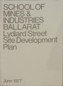
Book, School of Mines & Industries Ballarat Lydiard Streete Site Development Plan, 1977, 06/1977
... School of Mines & Industries Ballarat Lydiard Streete Site Development Plan, 1977......development plan...site...Brown soft covered book of the Lydiard Street Site Development Plan....Barker Library (top floor) Mount Helen goldfields Ballarat School of Mines and industry is a predecessor of Federation University Australia. ballarat school of mines development plan site development lydiard street site influences campus plan Ballarat School of Mines Campus Brown soft covered book of the Lydiard Street Site Development Plan. ...Ballarat School of Mines and industry is a predecessor of Federation University Australia.Brown soft covered book of the Lydiard Street Site Development Plan.ballarat school of mines, development plan, site development, lydiard street, site influences, campus plan, ballarat school of mines campus -
 Federation University Historical Collection
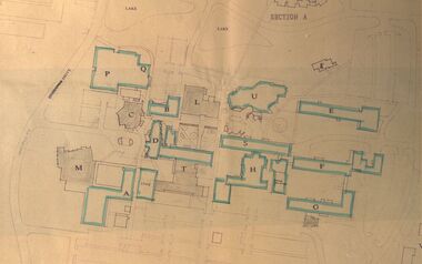
Plan, Site Plan of Ballarat School of Mines Campus, Lydiard St Ballarat, 1976
... Site Plan of Ballarat School of Mines Campus, Lydiard St Ballarat...Copy of site plan of SMB campus showing existing buildings, Stage 2 buildings, and future buildings....Site Plan of Ballarat School of Mines Campus, Lydiard St Ballarat Plan Plan ...Copy of site plan of SMB campus showing existing buildings, Stage 2 buildings, and future buildings.ewan jones, smb stage 2, b barbour, building plans, ballarat school of mines, buildings, ballarat school of mines, architectural plans -
Port Melbourne Historical & Preservation Society
Plan - Market site and Council Depot, City of Port Melbourne, City Engineer, City of Port Melbourne Site plan of Market Properties and Council Depot, 1938 - 1939
... City of Port Melbourne Site plan of Market Properties and Council Depot...City of Port Melbourne Site plan of Market Properties and Council Depot. ...Site plan also shows the library and old Fire Station. ...City of Port Melbourne Site plan of Market Properties and Council Depot. Site plan also shows the library and old Fire Station. Made approximately 1938 to 1939. Pencil markings show later use of the site when the market property was used as part of the council depot.red pen "686"built environment - civic, built environment - commercial, engineering department - city of port melbourne -
University of Melbourne, Burnley Campus Archives
Plan, 30 Lorne Pde Surrey Hills Preliminary Site Plan 1:100, c. 1980
... 30 Lorne Pde Surrey Hills Preliminary Site Plan 1:100...Tracing paper copy, "Preliminary Site Plan," by "?N." and a rough sketch on paper. ...Possibly Landscape Design Project 1978. 30 Lorne Pde Surrey Hills Preliminary Site Plan 1:100 Plan ...Tracing paper copy, "Preliminary Site Plan," by "?N." and a rough sketch on paper. Scale 1:100. Possibly Landscape Design Project 1978.surrey hills, landscape design -
University of Melbourne, Burnley Campus Archives
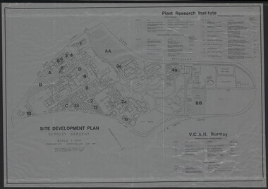
Plan - Photocopy, V.C.A.H. Burnley Site Plan, 1989
... V.C.A.H. Burnley Site Plan...Photocopy of site plan of the Victorian College of Agriculture and Horticulture. ...V.C.A.H. Burnley Site Plan Plan Photocopy ...Donated by Emma Ferguson and Jo van Berkel for their Oct 1994 Thesis.Photocopy of site plan of the Victorian College of Agriculture and Horticulture. Scale 1:500. Overall plan of garden with main buildings and gardens named. (Also see B11.0711 and B11.0715 for the same plan.)Note on reverse, "Not from Archives."victorian college of agriculture and horticulture, research institute, emma ferguson, jo van berkel -
Port Melbourne Historical & Preservation Society
Plan - Multi-unit development, 164 Ingles Street, Port Melbourne, Site Plan 164 Ingles Street, 2015
... Site Plan 164 Ingles Street...Site plan for multi unit development. 164 Ingles St, Port Melbourne 2015-2016 A3 sheet black and white printing On the site of Symex, J KItchen &Sons factory site...Port Melbourne Historical & Preservation Society Port Melbourne Town Hall 333 Bay Street Port Melbourne melbourne built environment - domestic woodruff street development pty ltd canny building pty ltd j kitchen & sons pty ltd symex holdings ltd Site plan for multi unit development. 164 Ingles St, Port Melbourne 2015-2016 A3 sheet black and white printing On the site of Symex, J KItchen &Sons factory site Site Plan 164 Ingles Street Plan Multi-unit development, 164 Ingles Street, Port Melbourne ...Site plan for multi unit development. 164 Ingles St, Port Melbourne 2015-2016 A3 sheet black and white printing On the site of Symex, J KItchen &Sons factory sitebuilt environment - domestic, woodruff street development pty ltd, canny building pty ltd, j kitchen & sons pty ltd, symex holdings ltd -
University of Melbourne, Burnley Campus Archives
Plan, Site plan 48 Barnard Grove Kew, 1995-1998
... Site plan 48 Barnard Grove Kew ...(1) Set of drawings - Folio 1995 by Meghan Bate includes Preliminary Plan 48 Barnard Grove Kew dated 1.6.95. (2) Tracing paper Site Plan. Scale 1:100. Unnamed. (3) Photocopy of Preliminary Plan of 'Hill Residence 48 Barnard Grove Kew' by Joanna Cutter, p3 of 4, dated 01.06.1998. ...Scale 1:100. Site plan 48 Barnard Grove Kew Plan ...(1) Set of drawings - Folio 1995 by Meghan Bate includes Preliminary Plan 48 Barnard Grove Kew dated 1.6.95. (2) Tracing paper Site Plan. Scale 1:100. Unnamed. (3) Photocopy of Preliminary Plan of 'Hill Residence 48 Barnard Grove Kew' by Joanna Cutter, p3 of 4, dated 01.06.1998. Scale 1:100.kew, joanna cutter, meghan bate -
 University of Melbourne, Burnley Campus Archives
Plan, Victorian College of Agriculture and Horticulture - Burnley Site Plan, 1986
... Victorian College of Agriculture and Horticulture - Burnley Site Plan...Scale 1:500. (1) 3 prints of the plan, 1 small, 2 larger (1 with legend and grid). (2) Tracing paper copy, no legend, no grid. (3) Paper copy, legend and grid, of Ornamental Garden Area. (4) "Drawing Orchard Site Plan," grid and legend printed, the rest hand drawn. (5) Film and paper copies without grid and legend. ...Victorian College of Agriculture and Horticulture - Burnley Site Plan Plan ...Given to Archives by Jim Galea (Staff 1985-87).Prints and paper copies of plan of Burnley Campus by Fresco Color Group No 60 337-A dated February 1986. Scale 1:500. (1) 3 prints of the plan, 1 small, 2 larger (1 with legend and grid). (2) Tracing paper copy, no legend, no grid. (3) Paper copy, legend and grid, of Ornamental Garden Area. (4) "Drawing Orchard Site Plan," grid and legend printed, the rest hand drawn. (5) Film and paper copies without grid and legend. N.B. 11.0716, Further development of Plan. vcah, burnley, fresco color group, orchard, burnley gardens -
 Sunshine and District Historical Society Incorporated
Plan - H.V. McKay Massey Harris & Massey Ferguson Maps
... Collection of site plans and aerial photograpths...McKay Massey Harris Maps Site Plan 1933 3152.04 - H.V. McKay Massey Harris Maps 1924 Site Plan 3152.05 - H.V. ...McKay Massey Harris Maps Site Plan 1933 3152.04 - H.V. McKay Massey Harris Maps 1924 Site Plan 3152.05 - H.V. ...3152.01 - H.V. McKay Massey Harris Maps 1922 Site Plan 3152.02 - H.V. McKay Massey Harris Maps Factory Gas And Water Plants 1941 3152.03 - H.V. McKay Massey Harris Maps Site Plan 1933 3152.04 - H.V. McKay Massey Harris Maps 1924 Site Plan 3152.05 - H.V. McKay Massey Harris Maps 1927 Site Plan 3152.06 - H.V. McKay Massey Harris Maps 1956 Type Of Buildings Site Plan 3152.07 - H.V. McKay Massey Harris Maps 1986 Restricted Area Construction Plan 3152.08 - H.V. McKay Massey Harris Maps Factory Gas And Water Control Plan 1941 3152.09 - H.V. McKay Massey Harris Maps Aerial Photoh.v. mckays massey ferguson, sunshine harvester works -
Dandenong & District Historical Society
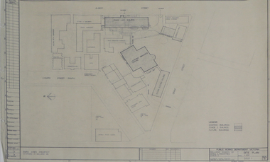
Document, Dandenong High School Existing Site Plan
... Dandenong High School Existing Site Plan...Dandenong & District Historical Society 1st Floor, 39 Clow Street Dandenong melbourne PDF Dandenong High School Existing Site Plan Document ...PDFnon-fiction -
 Whitehorse Historical Society Inc.
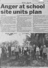
Newspaper - Article, Anger at school site plan, 23/10/1996
... Anger at school site plan...Anger at school site plan Newspaper Article ...Article in Whitehorse Gazette 28/10/1996 about objections by neighbouring residents to development of the Forest Hill Secondary College site.forest hill secondary college, mahoneys road, forest hill, canterbury road, thornhill drive, oscar, geoff, land subdivision -
University of Melbourne, Burnley Campus Archives
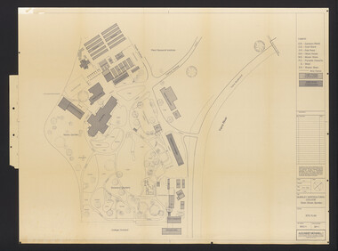
Plan, VCAH Burnley College, Swan Street Richmond - Site Plan 1:1000 Fire Services Survey, 1991
... VCAH Burnley College, Swan Street Richmond - Site Plan 1:1000 Fire Services Survey...VCAH Burnley College, Swan Street Richmond - Site Plan 1:1000 Fire Services Survey Plan ...Plan with Buildings named, External Hydrant Sources and Main Entry Points marked. Scale 1:1000. Dated January 1991.vcah, burnley, fire safety -
 University of Melbourne, Burnley Campus Archives
Plan, Burnley Horticultural College: Site Plan, 1983-1984
... Burnley Horticultural College: Site Plan...Burnley Horticultural College: Site Plan Plan ...Plans of the Burnley Campus, Ornamental Gardens from Plan 11.0715 by Alexander Metherell Pty. Ltd. Dated November 1983. Scale 1:500. (1) 5 copies, buildings shaded showing construction type. Job No BHC/1 Drawing No SP/1. Tree placements stamped on, includes legend. (2) 2 copies No SP/1c. In Description column, "A" Building Names 7/02/1984. Also see B15.0352 full report. B11.0715 originals. B11.0599 SP/3.ornamental gardens, burnley campus, burnley horticultural college, alexander metherell p/l -
 National Wool Museum
Archive - Architectural Plan, Plant Layout: R S & S Mill, 1973
... ...Site plan...Site plan of the R S & S Mill, 1st Dec, 1973....National Wool Museum 26 Moorabool Street Geelong geelong-and-the-bellarine-peninsula Site plan of the R S & S Mill, 1st Dec, 1973. ...Site plan of the R S & S Mill, 1st Dec, 1973.Architectural drawing on paper showing hand written diagrams and text. PE/C - 389textile mills - design textile mills - history, textile mills - design, textile mills - history, returned soldiers and sailors mill, r s & s mill, architecture, plan, site plan -
 University of Melbourne, Burnley Campus Archives
Plan, Site Development Plan - Burnley Gardens, 1988-1989
... Site Development Plan - Burnley Gardens...(1) Site development plan prepared by Steve Mullany June 1989. ...Includes legend. (2) 1 tracing paper copy, 3 paper copies, 1 enlargement (some slight variations). Site Development Plan - Burnley Gardens Plan ...Used by Honours student, Linda Hipwell in 1999.(1) Site development plan prepared by Steve Mullany June 1989. Scale 1:1000. Photogrammetric plot prepared for the VCAH by Stereometric Services from aerial photography taken 10.07.1988. Plant Research Institute, proposed major buildings 1989-99. Includes legend. (2) 1 tracing paper copy, 3 paper copies, 1 enlargement (some slight variations). plant research, linda hipwell, vcah, students -
 University of Melbourne, Burnley Campus Archives
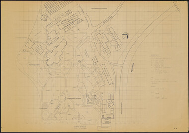
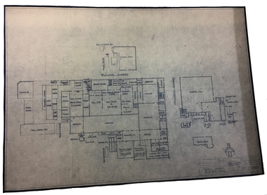
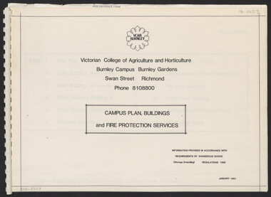
Plan, Campus Plan, Buildings and Fire Protection Services
... Site plan...Prepared by Fooks Martin Sandow, Architects. Site Plan: Scale 1:1000. All Others: 1:200. Main Building - Ground Floor, First Floor. ...Prepared by Fooks Martin Sandow, Architects. Site Plan: Scale 1:1000. All Others: 1:200. Main Building - Ground Floor, First Floor. ...site plan, buildings, administration building, plant science laboratories, quad, library, student amenities building, engineering, urban horticulture, nursery -
Glen Eira Historical Society
Plan - Mount Scopus College, St. Kilda East
... ... Site Plan...The planning brief describes the school’s facilities, classrooms, playground and the planned development of the school. It includes a site plan and an architect’s illustration of the proposed development....The planning brief describes the school’s facilities, classrooms, playground and the planned development of the school. It includes a site plan and an architect’s illustration of the proposed development. ...A copy of the amended Planning brief for the development of Mount Scopus College dated 24/10/1982. It includes a covering letter listing the amendments. The planning brief describes the school’s facilities, classrooms, playground and the planned development of the school. It includes a site plan and an architect’s illustration of the proposed development.mount scopus college, st. kilda east, city of caulfield, mayfield street, talbot avenue, floyd jeff, building permits, planning act, shaw house, m.m.b.w. planning scheme, classrooms, kindergarten, playgrounds, library, multipurpose hall, car parking, students, teachers, staff, secondary school, primary school, synagogue, architects, syman justin and bialek, site plan, hall, building development, education department, town and country planning board, brick, zoning, traffic, property, landscape planning, planting, fence -
 RMIT Design Archives
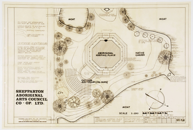
Work on paper - Architectural drawings, Aboriginal Keeping Place, Shepparton International Village
... Site plan drawing of the Shepparton Aboriginal Arts Council building, now known as the Bangerang Cultural Centre. ...Site Plan...RMIT Design Archives RMIt University, Building 100 154 Victoria Street Carlton melbourne Site plan drawing of the Shepparton Aboriginal Arts Council building, now known as the Bangerang Cultural Centre. ...Site plan drawing of the Shepparton Aboriginal Arts Council building, now known as the Bangerang Cultural Centre. The building is located in the Parkside Gardens, formerly the Shepparton International Village, and is the first Aboriginal cultural museum developed and managed by the Aboriginal community. The building is part of the Victorian Heritage Register. Romberg designed the building in conjunction with project instigator and Bangerang Elder, John Sandy Atkinson, OAM. At the request of Romberg, Atkinson created some concept sketches for the building from which Romberg designed the finished structure.Site PlanInitialed in grey pencil, bottom right: 'F.R'architecture, museum -
 Bendigo Historical Society Inc.
Plan - SANDHURST BOYS CENTRE COLLECTION: PART DETAIL SURVEY
... Sandhurst Boys Centre site plan;...Client is the Mental Health Department, Municipality is City of Bendigo. Site plan of area bounded by O'Dwyer St and Finn St, North Bendigo. ...BENDIGO Institutions sandhurst boys centre Sandhurst Boys Centre site plan; Prepared by the Public Works Department for the Government of Victoria. ...Prepared by the Public Works Department for the Government of Victoria. Client is the Mental Health Department, Municipality is City of Bendigo. Site plan of area bounded by O'Dwyer St and Finn St, North Bendigo. Handwritten note on back - Update of whole centre 10/4/91. Details include: oval, tennis court, grandstand, area is bounded by an un-named watercourse. Also indicated are 14 nissen huts, 2 toilet blocks, 3 weatherboard buildings, 1 galvanised iron building,2 galvanised iron sheds (one new), residence, garage, fowl shed, and a carpark. bendigo, institutions, sandhurst boys centre, sandhurst boys centre site plan; -
 Melbourne Tram Museum
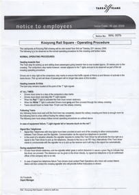
Document - Notice to Employees, Yarra Trams, "Kooyong Rail Square - Operating Procedure", Jan 2008
... Document provides information on the operation of the rail square (also known as a tram square, railway Square) at the Kooyong Glenferrie Road level crossing. Provides a site plan, signal information and operational procedures including when items fail. ...Single A4 sheet, printed double sided, with a coloured site plan....Melbourne Tram Museum 8 Wallen Road Hawthorn melbourne Document provides information on the operation of the rail square (also known as a tram square, railway Square) at the Kooyong Glenferrie Road level crossing. Provides a site plan, signal information and operational procedures including when items fail. ...Document provides information on the operation of the rail square (also known as a tram square, railway Square) at the Kooyong Glenferrie Road level crossing. Provides a site plan, signal information and operational procedures including when items fail. Dated 16/1/2008.Demonstrates an instruction into the operation of the Kooyong rail squareSingle A4 sheet, printed double sided, with a coloured site plan.trams, tramway square, rail square, railway square, glenferrie road, kooyong level crossing, operations, instructions -
Federation University Historical Collection
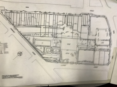
Book - Report, Lydiard Street Site Development Plan, School of Mines and Industries, Ballarat, 1977, 1977
... Lydiard Street Site Development Plan, School of Mines and Industries, Ballarat, 1977...Barker Library (top floor) Mount Helen goldfields The Ballarat School of Mines is a predecessor institution of Federation University Australia. ballarat school of mines lydiard street campus g.j. harrison Campus Plan master plan SMB Campus Ballarat School of Mines Campus Brown soft covered ring bound report of 20 pages. Lydiard Street Site Development Plan, School of Mines and Industries, Ballarat, 1977 Book Report ...The Ballarat School of Mines is a predecessor institution of Federation University Australia.Brown soft covered ring bound report of 20 pages. ballarat school of mines, lydiard street campus, g.j. harrison, campus plan, master plan, smb campus, ballarat school of mines campus -
Stawell Historical Society Inc
Map, Stawell Joint Venture, Mine Site Detail Plan, September 1989
... Mine Site Detail Plan ...Stawell Historical Society Inc 46 Longfield St Stawell grampians mining gold map 1989 Mine Site Detail Plan Map Stawell Joint Venture ...1989mining, gold, map -
 University of Melbourne, Burnley Campus Archives
Plan, M. Drake et al, Incubator Building and Random Sample Laying Test Burnley Gardens - Site Location Plan, 1967
... Incubator Building and Random Sample Laying Test Burnley Gardens - Site Location Plan...Plan by Public Works Dept., Melbourne. M. Drake (draughtsman), R. G. Wilson, Chief Architect. Incubator Building and Random Sample Laying Test Burnley Gardens - Site Location Plan Plan M. ...Plan by Public Works Dept., Melbourne. M. Drake (draughtsman), R. G. Wilson, Chief Architect.Copy 2 has some pencil additionsm. drake, g.r. wilson, burnley gardens, buildings, victoria public works department -
Whitehorse Historical Society Inc.
Map, Proposed Mitcham Shopping Centre, 1979
... Site plan and ground floor tenancy layout. Four stages of development for this shopping centre by Clarke Hopkins and Clarke Architects included....Proposed shopping complex of Mitcham - site plan and ground floor tenancy layout. Four stages of development for this shopping centre by Clarke Hopkins and Clarke Architects included....Whitehorse Historical Society Inc. 2-10 Deep Creek Road Mitcham melbourne Site plan and ground floor tenancy layout. Four stages of development for this shopping centre by Clarke Hopkins and Clarke Architects included. ...Proposed shopping complex of Mitcham.Proposed shopping complex of Mitcham - site plan and ground floor tenancy layout. Four stages of development for this shopping centre by Clarke Hopkins and Clarke Architects included.Proposed shopping complex of Mitcham.mitcham shopping centre, city of nunawading, coles supermarket, mitcham -
 Kew Historical Society Inc
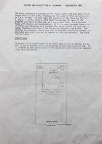
Document, Pru Sanderson Design Pty Ltd, History and Description of 'Glencara', Sackville Street, 1984-1988
... History, description, site plan and house plan of 'Glencara' at 59 Sackville Street, Kew....2-page document with site plan and internal layout of Glencara (b.1893,) 59 Sackville Street, Kew. ...Kew Historical Society Inc Kew Court House 188 High Street Kew melbourne History, description, site plan and house plan of 'Glencara' at 59 Sackville Street, Kew. glencara -- sackville street -- kew (vic) houses -- sackville street -- kew 2-page document with site plan and internal layout of Glencara (b.1893,) 59 Sackville Street, Kew. ...History, description, site plan and house plan of 'Glencara' at 59 Sackville Street, Kew.2-page document with site plan and internal layout of Glencara (b.1893,) 59 Sackville Street, Kew. The text in the document is identical to that in Pru Sanderson's Kew Conservation Study (1988).glencara -- sackville street -- kew (vic), houses -- sackville street -- kew