Showing 83 items matching "skyline road"
-
 Eltham District Historical Society Inc
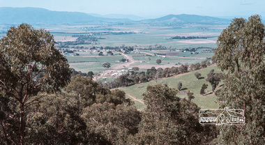
Photograph, Fred Mitchell, Yarra Glen Valley from lookout on Skyline Road, Yarra Glen, 1968, 1968
... Yarra Glen Valley from lookout on Skyline Road, Yarra Glen, 1968......Skyline Road...Eltham District Historical Society Inc 728 Main Rd Eltham melbourne fred mitchell collection 1968 Skyline Road Yarra Glen Digital copy of colour photograph Yarra Glen Valley from lookout on Skyline Road, Yarra Glen, 1968 Photograph Fred Mitchell ...Digital copy of colour photographfred mitchell collection, 1968, skyline road, yarra glen -
 Eltham District Historical Society Inc
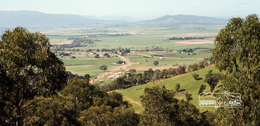
Photograph, Fred Mitchell, Yarra Glen Valley from lookout on Skyline Road, Yarra Glen, 1968, 1968
... Yarra Glen Valley from lookout on Skyline Road, Yarra Glen, 1968......skyline road...Eltham District Historical Society Inc 728 Main Rd Eltham melbourne fred mitchell collection 1968 skyline road yarra glen Digital copy of colour photograph Yarra Glen Valley from lookout on Skyline Road, Yarra Glen, 1968 Photograph Fred Mitchell ...Digital copy of colour photographfred mitchell collection, 1968, skyline road, yarra glen -
 Round the Bend Conservation Co-operative
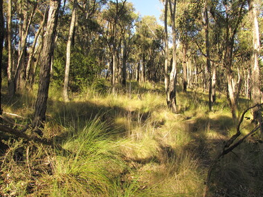
The Co-operative's aim of living in harmony with the bush provides a sanctuary for both flora and fauna in its box ironbark forest and grassy dry forest, 1980's
... Co-op Community Site, Skyline Road, Bend of Islands, Environmental Living Zone, Victoria, 3097 ...Colour photographround the bend co-op, environmental living zone elz -
 Melbourne Tram Museum
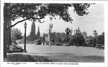
Postcard, Rose Stereograph Co, "The City skyline from St Kilda Road Melbourne", late 1930s
... "The City skyline from St Kilda Road Melbourne"...P4731 titled "The City skyline from St Kilda Road Melbourne". Photo looking north from the intersection Alexandra Ave, along St Kilda Road. ...Melbourne Tram Museum 8 Wallen Road Hawthorn melbourne Rose Series postcard No. P4731 titled "The City skyline from St Kilda Road Melbourne". ...Rose Series postcard No. P4731 titled "The City skyline from St Kilda Road Melbourne". Photo looking north from the intersection Alexandra Ave, along St Kilda Road. In the view is W2 class tram No. 600? (St Kilda Beach route 17). In the background are two other W2 class trams. A policeman is on point duty with all the southbound motor cars stopped in a line. The tram stop on the light standard in the middle of the road is also visible. See item 8037 for a similar view.Yields information about St. Kilda Road and Swanston Street mid 1930s.Postcard - printed real photograph with Rose Stereograph Co. name on the rear. Two copies held.Second copy has "From D J Harrington" in ink on the rear.tramways, trams, st kilda road, alexandra ave, tram 600, route 17, w2 class, swanston st -
 Ringwood and District Historical Society
Photograph, Looking at Menzies Drive, North Ringwood and the special storage section of the plant yard from Kubis Drive near Oban Road in Dec 1977
... Hubbard Park on skyline beyond road cutting in centre...Hubbard Park on skyline beyond road cutting in centre Part of a 101-photo record of the development of the "Bel Air" Estate, Ringwood North, including road works to Debbie Place, Kubis Drive, Jenkins Close, Burlock Avenue, Pamela Court, Manuelo Terrace, Lyn Court, Rudolf Court, Werac Drive, Iluka Place and Glenvale Road. ...Part of a 101-photo record of the development of the "Bel Air" Estate, Ringwood North, including road works to Debbie Place, Kubis Drive, Jenkins Close, Burlock Avenue, Pamela Court, Manuelo Terrace, Lyn Court, Rudolf Court, Werac Drive, Iluka Place and Glenvale Road. From the Jack Lundy Clarke collection (39 Burlock Avenue, North Ringwood) of photos taken from 1976 to 1982. The developer, Mr Kubis, named streets after his family and associates.Hubbard Park on skyline beyond road cutting in centre -
 Kiewa Valley Historical Society
Souvenir Postcard Folder – Falls Creek Ski Village
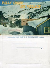
... road. Early lodges included Bogong (c.1946), Skyline (1947), Albury (1949), Myrtleford (1949) and Dawn (c.1950)....road. Early lodges included Bogong (c.1946), Skyline (1947), Albury (1949), Myrtleford (1949) and Dawn (c.1950). ...After World War II, the Kiewa Hydroelectric Scheme was started in the Kiewa River valley by the State Electricity Commission of Victoria. On land previously used only for summer cattle grazing in the natural alpine grasslands, the first ski lodge was built in 1948 by workers from the scheme. The first lift, a rope tow, was built in 1951 and the first chairlift in Australia was constructed there in 1957. Falls Creek Post Office opened on 9 June 1958 (with telegraph and telephone facilities only until 1964) .Despite strong opposition from the head of the Kiewa scheme, who didn't want tourists clogging up his roads and destroying his "dry" construction camps by bringing in booze, Falls Creek boomed as much as Hotham, partly owing to its relatively good access road. Early lodges included Bogong (c.1946), Skyline (1947), Albury (1949), Myrtleford (1949) and Dawn (c.1950).The souvenir postcard photographed and produced by an enterprising local businessman Mr S K Pearce, was produced as a memento for skiers and other visitors to the Falls Creek and Mt Beauty area to send to family and friends as a reminder of their visit to the region, or to keep as a personal souvenir. It presented an excellent promotional opportunity for enterprising local businessmen to promote the area to skiers and tourists near and far. It also presents an excellent pictorial history of the falls creek area around the late 1950’s to early 1960’sColour postcard folder (unused) containing 13 photographs of the Falls Creek ski area and surrounds. Inside cover has a brief description of the area and the services available to visitors Printed on front cover- FALLS CREEK SKI VILLAGE. Your Souvenir Folder Photo of skiing slopes of the village Inside front flap - a brief description of the Falls Creek area and the services available to visitors 1. Diana Lodge parking area and Spion Kopje 2. Winterhaven Lodge 3. Ski Hirage Centre and skiing slopes 4. Ski Lodges from main road 5. Nelse and Arundel Lodges 6. Day visitors’ shelter and parking area 7. Summit T-Bar lift 8. Spur T-bar looking towards Village and Spion Kopje 9. T-bar lower station and Snow Crystal Inn 10. ‘Akja’ rescue sled in use 11. Falls Creek road and Grand Coeur Lodge annex 12. Rope tows and beginner slopes 13. Back cover- Published by Nucolorvue Pty Ltd Mentone Vic. Printed in Australia For S.K.Pearce Pty Ltd Tawonga and Mt Beauty falls creek, snow, bogong high plains, victorian alps -
 Eltham District Historical Society Inc
Album - Document, J.A. McDonald, Report to Works Committee: Garbage Disposal, Eltham and Montmorency Ridings, c. 1956
... Road construction...Shire Engineer...Skyline...McDonald Montmorency Park Panorama Avenue Report Road construction Shire Engineer Skyline Theatre Tips W.U. Hughes Works Committee: Garbage Disposal Six typed foolscap pages Inserted in an album of 78 foolscap pages containing a sequence of photos, adhered via glue or sticky tape, with typed or handwritten headings and captions in pencil. ...Reference report associated with photos: EDHS_05569-30-4 Box Hill Tip EDHS_05569-30-6 Camberwell Tip EDHS_05569-30-7 Camberwell Tip EDHS_05569-30-8 Camberwell TipRecord of various Shire of Eltham infrastructure works undertaken during the period of 1952-1962 involving bridge and road reconstruction projects, sometimes with Eltham Shire Council Project Reference numbers quoted. It was during this period that a number of significant improvements were made to roads and new bridges constructed within the shire that remain in place as of present day (2022). In many situations, the photos provide a tangible visible record of infrastructure that existed throughout the early days of the Shire. The album was put together by or under the direction of the Shire Engineer, J.A. McDonald.infrastructure, shire of eltham, benchmark studies, box hill state school, box hill teachers college, box hill tip, andrew park, camberwell city council tip, eltham lower park, eltham tip, health inspector, heidelberg city tip, j.a. mcdonald, montmorency park, panorama avenue, report, road construction, shire engineer, skyline theatre, tips, w.u. hughes, works committee: garbage disposal -
 Greensborough Historical Society
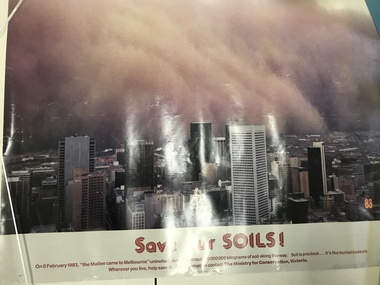
Poster, Victoria. Ministry for Conservation, Save our soils, 08/02/1983
... Greensborough Historical Society 34A Glenauburn Road Lower Plenty Lower Plenty melbourne In February 1983, Melbourne experienced a dust storm when red soil from the Mallee blew across the state of Victoria. This poster shown the red dust rolling across Melbourne's skyline ...In February 1983, Melbourne experienced a dust storm when red soil from the Mallee blew across the state of Victoria. This poster shown the red dust rolling across Melbourne's skyline.Colour poster printed on papermelbourne, dust storms, mallee -
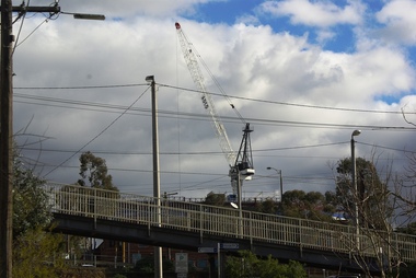 Greensborough Historical Society
Photograph - Digital image, Marilyn Smith, Crane at Watermarc, 11/08/2016
... Greensborough Historical Society 34A Glenauburn Road Lower Plenty Lower Plenty melbourne Cranes on the skyline at Watermarc development 2016. ...Cranes on the skyline at Watermarc development 2016. New Banyule Council offices are being built at 1 Flintoff Street, over the Watermarc building.Digital copy of colour photograph.watermarc, one flintoff, banyule council -
 Greensborough Historical Society
Photograph - Digital image, Marilyn Smith, Crane at Watermarc, 19/07/2016
... Greensborough Historical Society 34A Glenauburn Road Lower Plenty Lower Plenty melbourne Cranes on the skyline at Watermarc development 2016, taken from Main Street. ...Cranes on the skyline at Watermarc development 2016, taken from Main Street. New Banyule Council offices are being built at 1 Flintoff Street, over the Watermarc building.Digital copy of colour photograph.watermarc, one flintoff, banyule council, main street greensborough -
 Greensborough Historical Society
Photograph - Digital image, Workers removing blackout sheets from SLV Dome with Melbourne skyline in background, 1947, 1947_
... Greensborough Historical Society 34A Glenauburn Road Lower Plenty Lower Plenty melbourne This photograph shows workers removing the blackout material from the State Library of Victoria Dome in 1947. The Melbourne skyline ...This photograph shows workers removing the blackout material from the State Library of Victoria Dome in 1947. The Melbourne skyline is in the background.This is a copy of one of the photographs donated to the SLV by GHS member Rex Smith in 2003.Digital copy of black and white photograph.rex smith -
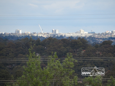
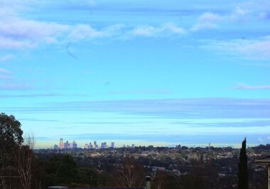 Greensborough Historical Society
Photograph - Digital image, Marilyn Smith, Melbourne City skyline from Greensborough, 16/08/2015
... Greensborough Historical Society 34A Glenauburn Road Lower Plenty Lower Plenty melbourne Greensborough is approximately 23 kilometres from the Melbourne Central Business District. This photo of the Melbourne skyline ...Greensborough is approximately 23 kilometres from the Melbourne Central Business District. This photo of the Melbourne skyline was taken from Greensborough.Digital copy of colour photographgreensborough, melbourne -
 Greensborough Historical Society
Slide - Slide Set, Nu-Color-Vue Slide, Slides of Melbourne, 1970s
... Greensborough Historical Society 34A Glenauburn Road Lower Plenty Lower Plenty melbourne Travel slides were often purchased as a memento of a city visited. This collection of slides is of Melbourne circa 1970s, including the city skyline, Yarra and MCG, St Patrick's Cathedral and Princes Bridge and city skyline at dusk. ...Travel slides were often purchased as a memento of a city visited. This collection of slides is of Melbourne circa 1970s, including the city skyline, Yarra and MCG, St Patrick's Cathedral and Princes Bridge and city skyline at dusk. Also includes slides of a koala and a kookaburra.5 colour slides slide sets, travel slides, melbourne, koalas, kookaburras -
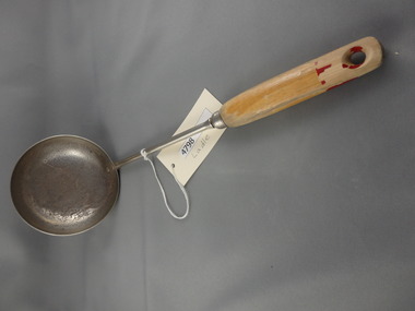 Greensborough Historical Society
Kitchenware, Ladle, 1950s
... Greensborough Historical Society 34A Glenauburn Road Lower Plenty Lower Plenty melbourne Kitchen ladle, circa 1950s. kitchenware ladles "Skyline" Metal soup ladle with wooden handle painted red Ladle Kitchenware ...Kitchen ladle, circa 1950s.Metal soup ladle with wooden handle painted red"Skyline"kitchenware, ladles -
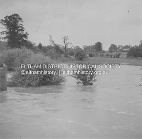 Eltham District Historical Society Inc
Album - Photograph, J.A. McDonald, Eltham-Greensborough Road, 18 Oct. 1956
... skyline to the right of centreeline is a gap in the trees where the railway line runs. The Silver Street bridge over the railway is visible. Beware!.. our rivers are rising (1956, October 19). The Argus (Melbourne, Vic. : 1848 - 1957), p. 1. Retrieved August 24, 2022, from http://nla.gov.au/nla.news-article84392304 Record of various Shire of Eltham infrastructure works undertaken during the period of 1952-1962 involving bridge and road reconstruction projects, sometimes with Eltham Shire Council Project Reference numbers quoted. ...Bridge Street Bridge Flooding on Hill’s property 18th October 1956 This view is looking west north west from the Bridge Street Bridge across the present day Eltham Skatepark. The shed visibile in the distance is directly opposite Brisbane Street where it used to run into Susan Street but now turns the corner. To the right of the shes is the site for present-dayHarris Plumbing which was formerly occupied by Sibbel Builders; to the left the site now occupied by Bunnings. At the skyline to the right of centreeline is a gap in the trees where the railway line runs. The Silver Street bridge over the railway is visible. Beware!.. our rivers are rising (1956, October 19). The Argus (Melbourne, Vic. : 1848 - 1957), p. 1. Retrieved August 24, 2022, from http://nla.gov.au/nla.news-article84392304Record of various Shire of Eltham infrastructure works undertaken during the period of 1952-1962 involving bridge and road reconstruction projects, sometimes with Eltham Shire Council Project Reference numbers quoted. It was during this period that a number of significant improvements were made to roads and new bridges constructed within the shire that remain in place as of present day (2022). In many situations, the photos provide a tangible visible record of infrastructure that existed throughout the early days of the Shire. The album was put together by or under the direction of the Shire Engineer, J.A. McDonald.infrastructure, road construction, shire of eltham, bridge construction, bridge street bridge, eltham, eltham-greensborough road, 1956-10-18, diamond creek (creek), floods, floodwater, hill property, silver street bridge -
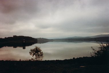 Eltham District Historical Society Inc
Photograph, Sugarloaf Reservoir from Skyline Drive, 1989, 1989
... Road, Eltham, Vic. 3095; relocated to archival safe storage. Sugarloaf Reservoir is situated on former farmland. This large water storage was completed in 1982 and serves Melbourne's northern suburbs. Within the visitor areas are two picnic grounds and other recreational facilities. Below its massive rock embankment is located the Winnecke Treatment Plan designed to purify its water before being piped into Melbourne. The dam partly inundated the old firing ranges of the former Christmas Hills Rifle Club. Source: Christmas Hills Now and then: Yarra Glen & District Historical Society, 2004. skyline ...Originally contained in a 'magnetic' photo album believed to have been donated by Mr Eric Stephenson, Jingalong, 110 Ryans Road, Eltham, Vic. 3095; relocated to archival safe storage. Sugarloaf Reservoir is situated on former farmland. This large water storage was completed in 1982 and serves Melbourne's northern suburbs. Within the visitor areas are two picnic grounds and other recreational facilities. Below its massive rock embankment is located the Winnecke Treatment Plan designed to purify its water before being piped into Melbourne. The dam partly inundated the old firing ranges of the former Christmas Hills Rifle Club. Source: Christmas Hills Now and then: Yarra Glen & District Historical Society, 2004. Two colour photographsskyline drive, sugarloaf reservoir -
 Eltham District Historical Society Inc
Photograph, Liz Pidgeon, Heritage Excursion; Maroondah Aqueduct, 3 September 2016, 3 September 2016
... Road North, officially Diamond Creek, but on the northern boundary of Eltham. (Melway ref.12 B10). maroondah aqueduct eltham north activities eltham district historical society heritage excursion skyline melbourne Aqueduct trail Born Digital Heritage Excursion; Maroondah Aqueduct, 3 September 2016 Photograph Photograph Liz Pidgeon ...Photo of Melbourne City skyline. Newsletter No., 229, August 2016 Heritage Excursion - Maroondah Aqueduct Walk - Saturday 3rd September The Maroondah Aqueduct was once a major link in Melbourne’s water supply system. It was built between 1886 and 1891 to transfer water from the Watts River near Healesville to the Preston Reservoir. It was 66 km in length, made up of 41 km of open channel, 10 km of tunnel through hills and 15 km of pipeline across stream valleys known as inverted siphons. The section of the aqueduct through the Eltham area has been abandoned since the 1980s but the open channel has largely been retained. A recreational path follows the aqueduct reserve. For our excursion on 3rd September we intend to walk along the section of the aqueduct adjacent to Allendale Road. This is a section not visited on previous excursions and includes the transition from open channel to the inverted siphon across the Diamond Creek valley. Apart from the aqueduct itself the main feature of the walk is the extensive views across Eltham North and Diamond Creek. Along the way we will talk about the history of the aqueduct and the area. This easy walk is about 3 km return and will take 2 to 2.5 hours. It will start at 2pm at the junction of Allendale Road with Godber Road and Zig Zag Road North, officially Diamond Creek, but on the northern boundary of Eltham. (Melway ref.12 B10). Born Digitalmaroondah aqueduct, eltham north, activities, eltham district historical society, heritage excursion, skyline, melbourne, aqueduct trail -
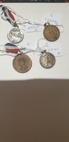 Colac RSL Sub Branch
Medal - Medals x 4, a) Centenary of Melbourne medal. b) Borough & Shire of Colac. 1945 Peace & Victory Medal. c) Coronation Medal 1937. d) Victory Medal 1945, NK
... Colac RSL Sub Branch 21 Murray Street Colac great-ocean-road Commemorative medallions medium a) Front:- Centenary of Melbourne. 1932. Man looking at city skyline. 1835. ...Commemorative medallionsmediumRound commemorative medals x 4. a) Silver coloured medal with a with Red, white and blue ribbon. b) Bronze coloured medal. No ribbon c) Bronze " " with a red, white and blue ribbon d) Silver " " . No ribbon a) Front:- Centenary of Melbourne. 1932. Man looking at city skyline. 1835. Back:- Centenary of Victoria. 1934. Sailing ship/shoreline. 1834 b) Front:- Borough & Shire of Colac. Coat of Arms surrounded by wreath and crossed swords. Back:- Peace and Victory. Surrounded by a wreath c) Front:- King George VI & Queen Elizabeth. Portraits of King and Queen Back:- To Commemorate their Majesties' Coronation d) Front:- Man with a sword on a map of Australia. 1945 Back:- Map -
 Port Melbourne Historical & Preservation Society
Photograph - Port Melbourne foreshore, Elizabeth Cromb, 1990s
... Road, after wetlands had been created by the cleanup of the BP site. Before the building of Beacon Cove. Natural Environment Beacons Town Planning Built Environment Piers and Wharves - Station Pier Piers and Wharves - Princes Pier Transport - Ferries Elizabeth CROMB Beacon Cove One of two colour photos Port Melbourne foreshore, taken and sent by Elizabeth CROMB: Beacon Cove site pre-development. City skyline ...Photographed by Betty CROMB, who lived at corner of The Boulevard and Barak Road, after wetlands had been created by the cleanup of the BP site. Before the building of Beacon Cove.One of two colour photos Port Melbourne foreshore, taken and sent by Elizabeth CROMB: Beacon Cove site pre-development. City skyline in background. View toward inland beacon and temporary wetlands soon to become Beacon Cove (The supplementray file is a letter from the donor)natural environment, beacons, town planning, built environment, piers and wharves - station pier, piers and wharves - princes pier, transport - ferries, elizabeth cromb, beacon cove -
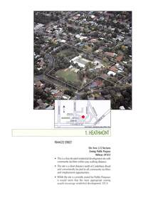 Ringwood and District Historical Society
Document - Advertisement, Sale by Tender - Residential Development Site - Frances Street, Heathmont, Victoria - 1999
... Road Ringwood North melbourne Tenders close 12:00 noon on Wednesday 5th May, 1999. Agents - Colliers Jardine - William Carew 0412 539 717; Peter Bremner 0412 326 942. 2-page extract from booklet advertising development sites for sale by tender under instructions from the Education Department of Victoria. Includes aerial view and location map of former Heathmont Primary School site. (Subsequent residential development of Skyline ...2-page extract from booklet advertising development sites for sale by tender under instructions from the Education Department of Victoria. Includes aerial view and location map of former Heathmont Primary School site. (Subsequent residential development of Skyline Place, Heathmont.)Tenders close 12:00 noon on Wednesday 5th May, 1999. Agents - Colliers Jardine - William Carew 0412 539 717; Peter Bremner 0412 326 942. -
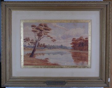 Glenelg Shire Council Cultural Collection
Painting, A.S. Murray, Scene on the River Murray, n.d
... road Art collection Previously located in History House Front: A.S. Murray Plaque attached to frame: SCENE on the RIVER MURRAY Back: (no inscriptions) The painting depicts a large body of water surrounded by tree-covered riverbank. Depicted in shades of blue and grey, the water features patches of brown and blue which illustrate the reflections of riverbank trees. In the foreground to the left of the water is a large tree which extends up to cover the top left skyline ...Art collection Previously located in History HouseThe painting depicts a large body of water surrounded by tree-covered riverbank. Depicted in shades of blue and grey, the water features patches of brown and blue which illustrate the reflections of riverbank trees. In the foreground to the left of the water is a large tree which extends up to cover the top left skyline of the work. Featured in the background is a dense patch of trees completed in shades of blue. To the right of the water is a dense patch of trees completed in shades of brown and black. These trees reach into a purple and blue cloud-filled sky. The work has a gilded ornate frame with cardboard and gold mount and exposed canvas.Front: A.S. Murray Plaque attached to frame: SCENE on the RIVER MURRAY Back: (no inscriptions) -
 Ringwood and District Historical Society
Photograph, View East from Avery Crt North Ringwood. 1981
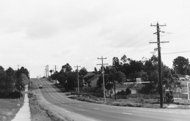
... Ringwood and District Historical Society 125A Warrandyte Road Ringwood North melbourne Written on back of photograph, "24/8/81. View EAST from Avery Crt Nth Ringwood. Wonga Rd in centre below clump of pine trees on skyline. ...Written on back of photograph, "24/8/81. View EAST from Avery Crt Nth Ringwood. Wonga Rd in centre below clump of pine trees on skyline. -
 Ringwood and District Historical Society
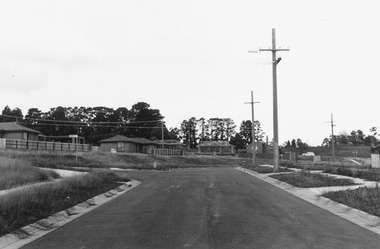
Photograph, Northward view from Mullum Road corner, Oban Road, Ringwood - 1981
... Oban Road between Mullum and Wonga Roads (on skyline)".....Oban Road between Mullum and Wonga Roads (on skyline)".. Northward view from Mullum Road corner, Oban Road, Ringwood - 1981. ...Written on back of photograph, "E622, N6, 1981. Oban Road between Mullum and Wonga Roads (on skyline)".. -
 Ringwood and District Historical Society
Photograph, Southward view from the end of Jull Road, North Ringwood - 1981, later extended as Jull Parade
... Jull Road, North Ringwood from its temporary end looking south towards the sports ground (on skyline). ...Jull Road, North Ringwood from its temporary end looking south towards the sports ground (on skyline). ...Written on back of photograph, "E621. N4. 1981. Jull Road, North Ringwood from its temporary end looking south towards the sports ground (on skyline). The white car is on Oban Road". -
 City of Melbourne Libraries
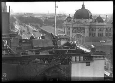
Photograph, Bull, Hugh Jones, 1897-1993, Fire at Cathedral Hotel, Swanston Street, Melbourne
... skyline, while not in clear focus, is of interest. On the right is the impressive dome of Flinders Street Station, with the clock at 4.50 pm. Its grand frontage, and some of the façade along Flinders Street, are visible. To the left is the wide and grand-scaled St Kilda Road...skyline, while not in clear focus, is of interest. On the right is the impressive dome of Flinders Street Station, with the clock at 4.50 pm. Its grand frontage, and some of the façade along Flinders Street, are visible. To the left is the wide and grand-scaled St Kilda Road ...Fire at the Cathedral Hotel! Southward view Firemen in their shiny brass Merryweather style helmets battle a fire in the roof of the Cathedral Hotel, Tuesday 3 March 1936. It was located on the corner of Swanston Street and Flinders Lane and so named for its proximity to St Paul’s Cathedral, just visible at top left. The fire broke out in between the roof space and wooden ceiling of the hotel at around 4.30 pm, causing disruption to afternoon commuters – hence the banked-up trams along St Kilda Road. The hoses snaking across the roof have been dragged up through the hotel’s front door. The scene of devastation on the roof appears to be a result of both the fire and firefighting efforts. The panoramic background is dominated by the dome of Flinders Street Station, the wide, treed boulevard of St Kilda Road, and a densely built-up industrial area south of the Yarra with its elevated signage and substantial buildings. Featured in "Newsworthy: Melbourne in photographs 1933-1936" exhibition at East Melbourne Library, October to December 2023. Exhibition caption by project volunteer, Louise McKenzie. Photographer notations on slide: "Fire at Cathedral Hotel Swanston St 1936 B104" Description: This photo, taken from an adjacent building, shows 12 firemen fighting a fire on the roof of the Cathedral Hotel, Melbourne. There is evidence of considerable damage to the roof of the building as a result of the fire and fire fighting efforts. The photo gives a feeling of elevation, as the firemen are in focus, with an out of focus panoramic background, showing the dome of Flinders Street Station, and St Kilda Road down to the Shrine. Research by project volunteer, Louise McKenzie: The Age reported on 4 March 1936 that the fire broke out in rubbish between the roof space and wooden ceiling of the Cathedral Hotel at 4.30 pm. “The Eastern Hill fire brigade was notified by telephone, and an almost simultaneous call was also received at fire brigade headquarters from a street alarm.” The firemen in their dark uniforms with brass buttons, gold epaulettes and shiny brass Merryweather helmets, stand out against the broken slate tiles and dislodged timber of the damaged roofing, all of which look blackened and in disarray. Two pale water hoses snake thickly across the roof. It is a scene of some devastation and chaos. Three chimney pots by contrast sit plump and strong against the damage. The Cathedral Hotel is located on the corner of Swanston Street and Flinders Lane, so named due to its proximity to St Pauls Cathedral (just visible at far left) on the corner of Flinders and Swanston streets. This intersection is a hub and focus of Melbourne activity. The backgrounded Melbourne skyline, while not in clear focus, is of interest. On the right is the impressive dome of Flinders Street Station, with the clock at 4.50 pm. Its grand frontage, and some of the façade along Flinders Street, are visible. To the left is the wide and grand-scaled St Kilda Road, leading down to the Shrine of Remembrance. There are many trams on Princes Bridge (mostly heading northward), together with some trucks and pedestrians. The pedestrian walkway along Princes Bridge is wide, and the Bridge balustrade lined with flag poles. The middle background shows a large number of trees. This was the site of Wirths Brothers Circus, an impressive complex including an octagonal circus Hippodrome (5000 seat auditorium), Pleasure Park, roller skating rink, and Dance Hall. Today it is the site of the Melbourne Arts Centre. Adjacent to the station is a large covered area, still extant today as part of the Station precinct. Floating above the horizon is sign advertising 'DUNLOP', located in the formerly industrial area which is today’s Southbank. Port Phillip Bay is faintly visible in the distance. The city seems sprawling, but uncrowded, and well punctuated by trees. Two photos were included an Age pictorial, one showing the firefighters at work, the other a crowd scene at street level (see References). These images are not part of the McKenzie Collection. References: No title (1936, March 4). The Age (Melbourne, Vic. : 1854 - 1954), p. 13. Retrieved February 5, 2024, from http://nla.gov.au/nla.news-article205256255 FIRE AT A CITY HOTEL. (1936, March 4). The Age (Melbourne, Vic. : 1854 - 1954), p. 12. Retrieved February 5, 2024, from http://nla.gov.au/nla.news-article205256231 FIRE IN ROOF OF CITY HOTEL (1936, March 4). The Argus (Melbourne, Vic. : 1848 - 1957), p. 8. Retrieved February 5, 2024, from http://nla.gov.au/nla.news-article11018696 Hotel Roof Fire Draws Crowd (1936, March 4). Examiner (Launceston, Tas. : 1900 - 1954), p. 8 (DAILY). Retrieved February 5, 2024, from http://nla.gov.au/nla.news-article52000751 'Flinders Lane Melbourne 1966', Peter Andrew Barrett, Facebook, 12 June 2020, https://www.facebook.com/120943481324886/photos/a.512123662206864/3025002490918956/?type=3Photographer notations on slide: "Fire at Cathedral Hotel Swanston St 1936 B104".fires, 1930-1939, hotels -
 City of Melbourne Libraries
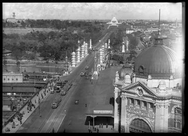
Photograph, Bull, Hugh Jones, 1897-1993, Princes Bridge Centenary pylons under construction
... The roadway in the foreground is an extension of Swanston Street, which becomes Princes Bridge, then St Kilda Road, stretching towards the Shrine of Remembrance, and diverting past it. The Shrine had not yet been officially dedicated, and looks very white and dominant on the skyline. ...The roadway in the foreground is an extension of Swanston Street, which becomes Princes Bridge, then St Kilda Road, stretching towards the Shrine of Remembrance, and diverting past it. The Shrine had not yet been officially dedicated, and looks very white and dominant on the skyline. ...Princes Bridge Centenary pylons under construction Possibly taken from Young and Jacksons Hotel (formerly Princes Bridge Hotel) on the corner of Flinders and Swanston streets, Flinders Street Station’s clocks and main entrance dominate, along with its distinctive copper dome and decorative façade. The time on the main clock is 1.40pm, and the sign underneath, reflecting Melbourne’s upcoming Centenary reads, “We must accommodate our Centenary visitors! Citizens! Do your share by taking paying guests.” At left is the original Princes Bridge Station, today the site of Federation Square. The riverside tram terminus advertises a Café/Tobacconist/Refreshment Room selling cigars & cigarettes, fountain drinks & confectionery, and in smaller text: “Leave your boot repairs here”. Nearly everyone is dressed in dark suits, coats and hats. The footpaths are wide and there are no traffic lights. The roadway stretches towards the Shrine of Remembrance, not yet dedicated but very dominant on the skyline. Government House is clearly visible across the wide parkland that would come to be known as Kings Domain and that is an area of deep importance to the people of the Eastern Kulin. Originally, Birrarung was part of a network of swamps and lagoons linked to the course of the river. From 1896, Public Works Department engineer Carlo Catani, oversaw a new channel to straighten the river and the swamps and lagoons were filled with spoil from the channel works. From the same vantage point today, only the top of the tower of Government House would be visible. The photo captures the pylons along Princes Bridge, mid-construction and being installed to mark Melbourne’s Centenary. The pylons were not without controversy. Both The Argus and The Age bemoaned them for being “made almost entirely of imported softwood timber”, denying work to native hardwood timber workers and sawmillers, and leading visitors to think Australia did not have its own exceptional native hardwoods. The pylons were also variously described in their incomplete state, as unimaginative and resembling an oilfield. Published: The Age 5 September 1934 Featured in "Newsworthy: Melbourne in photographs 1933-1936" exhibition at East Melbourne Library, October to December 2023. Exhibition caption by project volunteer, Louise McKenzie Photographer notations on slide: "Pylons + St Kilda Rd C57" Published: Age (Melbourne, Vic. : 1854 - 1954), Wednesday 5 September 1934, page 11 Published title: DECORATIONS -- THEN AND NOW. Published caption: "Although not completed yet, some impression of the effect of the decorations on Princes-bridge may be obtained from the first picture which shows the majestic sweep of St Kilda road with the Shrine of Remembrance and Government House dominating the horizon. The area to the left of St. Kilda-road and in front of Government House is portion of the area which it is proposed to call the King's Domain, which extends to Domain-road and Anderson-street..." Description: East-facing, elevated view of Flinders Street Station and Princes Bridge, featuring partially completed pylons erected for Melbourne's Centenary celebrations. The Shrine of Remembrance and Government House can be seen in the distance. In the foreground are trams, cars and trucks, pedestrians, Batman Avenue tram terminus and refreshment rooms. Signage on Flinders Street Station encourages citizens to accommodate Centenary visitors. The Melbourne Centenary was held 1934-35 in celebration John Batman's proclamation that Melbourne "the place for a village". Centenary events included a visit by Prince Henry, Duke of Gloucester. A Centenary Cake measuring 50 feet in height and ten tons in weight was cut into 250,000 pieces and sold at 1 shilling per piece for charity. Spectacular floodlighting of city landmarks, the creation of the Pioneer Women's Memorial Garden, and the MacRobertson Air Race from London, were other notable activities. Research by project volunteer, Louise McKenzie: The photo in The Age collage of 5 September 1934 has a slightly cropped foreground. The original photo has been taken from an elevated vantage point, most probably the roof of the Nicholas Building on the corner of Flinders and Swanston streets. The right foreground is dominated by the main “clocks” entrance to Flinders Street Station, showing its distinctive copper dome and decorative façade. The time on the main clock is 1.40 pm. The main sign on the front of the Station reads, "We Must Accommodate our Centenary Visitors! Citizens! Do your share by taking paying guests. Write to The Official Centenary Accommodation Bureau, 436 Collins St. City. Tel M 4671”. Another sign at eye level at the main entrance says: “Cheap Trips on Sundays”. The sign on the end of the roof along the eastern side of the station reads, “The Babies Need Your Help! Support Broadmeadows Foundling Hospital Appeal. July and August”. Run by the Sisters of St Joseph of the Sacred Heart, St Joseph’s Foundling Hospital was a purpose built infants’ home for up to 300 babies, plus accommodation for expectant mothers, mainly single women. In the early 1930s, the department (Victorian Children’s Welfare Department) contracted St Joseph’s Foundling Hospital to care for an additional 60 infant state wards, and up to 175 non wards at any given time. In 1931 it also operated a mothercraft training school. The centre foreground shows the commencement of Princes Bridge. Beneath the left side of the bridge was the site of the original Princes Bridge Station, by this time incorporated into Flinders Street Station, and today the area is the site of Federation Square. It was linked to Flinders Street station by the railway tracks that ran underneath the northern approach to the bridge. This photo shows a tram terminus which has a Café/Tobacconist/Refreshment Room, selling cigars & cigarettes, fountain drinks & confectionary, and a sign: Leave your boot repairs here. In the foreground is a wide roadway running south/north, comprising two vehicle lanes each heading north/south, and a central section containing two sets of tram tracks. There are cars, buses and delivery vans on the roadway. The trams visible are Glen Iris (Route No. 6; tram no. 448), Toorak (Route No. 8, tram no. 333), ? (No. 7), ? (No. 1), and ? (No. 2A). The footpaths are extremely wide. There is a square newspaper/magazine stand on the eastern side footpath. And also a “Ferry” sign. There are no traffic lights, but a policeman is visible on the roadway. There are pedestrians – men, women, children, a porter with trolley, women with prams. Clothing comprises dark suits, coats and hats for nearly everyone. There are double headed “Collins Street” lights along the side of the roadway, and along the northern riverbank. The roadway in the foreground is an extension of Swanston Street, which becomes Princes Bridge, then St Kilda Road, stretching towards the Shrine of Remembrance, and diverting past it. The Shrine had not yet been officially dedicated, and looks very white and dominant on the skyline. On the LHS of St Kilda Road, Government House is clearly visible across the wide parkland to be known as Kings Domain. The Kings Domain area is important to the people of the Eastern Kulin nation, and also has historical importance for its association with the early settlement of Melbourne and the foundation of British colonial administration in Victoria. On the southern side of the Yarra River (Birrarung) an historic rowing boathouse is visible, located adjacent to the Alexandra Gardens. Originally Birrarung was part of a network of swamps and lagoons linked to the course of the river. From 1896, under the guidance of engineer Carlo Catani* a new channel to straighten the river was created and the swamps and lagoons were filled with spoil from the channel works. The gardens were then created and completed in time for a Royal visit by the Duke of York in May 1901. The gardens are named after Alexandra of Denmark, the wife of King Edward VII. Both these areas, plus the Royal Botanic Gardens Victoria, Shrine of Remembrance Reserve, Sidney Myer Music Bowl, Government House, and the Queen Victoria Gardens together form the Domain Parklands. The extent of the subsequent plantings is evident today, where from the same vantage point only the top of the tower of Government House would be visible. *Catani was born in Florence in 1852, but after arriving in Melbourne worked as a civil engineer for the Victorian Government. His last major project was the reclamation of the foreshore of St Kilda, envisaged in the style of a European resort, complete with a split level esplanade, bathing pavilions, dance halls, amusements and a French-Italian style of landscape complete with palms. The gardens at the end of Fitzroy Street, St Kilda, now bear his name. The historic boathouse visible across the Yarra is another glimpse into Melbourne’s past. “Boathouse Row” comprises 7 amateur rowing clubs, the first established in 1859 (Melbourne University Boat Club). Other Clubs were Richmond, Melbourne, Banks, Melbourne Grammar School, Yarra Yarra and Mercantile. South of the river and west of the bridge is an area today developed into the Melbourne arts precinct of Hamer Hall and the Arts Centre. But at this time it was the home of Wirths Olympia Circus, which comprised Wirths Pleasure Park (an amusement park), a 5,000 seat auditorium – Hippodrome, a roller skating rink, a glaciarium, a cinema, and the Green Mill Dance Hall. Dog shows were also held at Olympia. The Green Mill Dance Hall closed in 1950, and the remainder of the Wirth buildings on site were destroyed by fire in December 1953. The feature of the photo is the pylons erected along Princes Bridge to mark Melbourne’s Centenary in 1934. The sixteen plastered pylons were designed by Roy Prentice, the second person to qualify as an architect at The University of Melbourne’s Bachelor of Architecture degree, in 1933, aged 27. Simon Reeves in his article marking the 100th birthday of Roy Prentice on 20 June 2006 reports that the State Electricity Commission sponsored this work, and the Argus reported that “… the pylons were “illuminated from within to give the effect of soft radiance”. Australia Home Beautiful 1 Oct 1934 reports in a very detailed and comprehensive article: The 10 taller pylons, including flagpole, were 48 ft, with a base of 8 ft. Timber-framed and faced with fibrous plaster and galvanised sheet iron, each structure was securely bolted to a concrete foundation three feet in depth. Panels of glass let into the shaft of each pylon were indirectly lit by 40, 100 watt lamps, and the upper bank of internal lamps were dyed so as to flood the panels with a deep red light. The decorative painted shields and flagpoles/pennants were illuminated by three 200 watt projectors concealed in the roof of each pylon, and were part of an electric night light decoration scheme involving 28 miles of wire to supply more than 20,000 lights. An article in the Argus on 18 October 1934 provided minute detail of the lighting erected in Melbourne for the Centenary, converting it “… into a coloured fairyland by night.” The estimated cost of 10 pounds per hour the lights were on. The display included 800 standard light poles 30 feet high which were tiered with electric bulbs concealed in inverted cones, 138 specially designed “Venetian poles” draped in flags trophies and streamers. The streets included in the electric night light decoration scheme were Bourke Street from Spring to William, the entire length of Collins Street, Flinders Street from Elizabeth to Spring, Lonsdale Street from Elizabeth to Swanston, Swanston and Elizabeth Streets from Flinders to Lonsdale, and parts of Springs and Spencer Streets. Together with the Princes Bridge pylons, approximately 28 miles of wire was required to supply power to the more than 20,000 lights. And that is just in the city of Melbourne. It was estimated the same amount of lighting was duplicated among other local councils. The pylons were not without controversy. The Argus on 28 August 1934 in an article headed “Imported Timber in Pylons” reported that the Princes Bridge pylons are “made almost entirely of imported softwood timber”, and have therefore denied work to native hardwood timber workers and sawmillers. The same day the Melbourne Age ran a similar story, bemoaning the fact that foreign oregon had been used which may lead tourists to think Australia did not have its own exceptional native hardwoods. A Camberwell City Councillor described the pylons as unimaginative, and the Herald reported that skeletons of pylons for the Centenary decorations in their present form led the area to resemble an oilfield! The Yarra River and Princes Bridge have long been a focal point of Melbourne life. In the early days of European settlement in Melbourne a rope-hauled punt carried people across the Yarra River. A surge in population and increased shipping traffic created a need for a bridge. There was difficulty in agreeing on a suitable site for the bridge (options were crossing at Elizabeth, Swanston, Queen or Market Streets), but the NSW Government favoured Swanston Street and the Melbourne Town Council decided on a temporary bridge across the Yarra spanning from the foot of Swanston Street. This first bridge was a single span timber toll bridge designed by Scottish born bridge designer David Lennox, and completed in 1845. It was 120 feet long, had a roadway of 17 feet wide, and a footpath on one side of 4 feet. It was leased to the Melbourne Bridge Company in the name of Robert A Balbirnie. The tollhouse was on the north side of the river and the toll keeper, Patrick Doherty, was credited with saving nine lives during the four years he was in charge of the toll station. The second bridge was stone (completed 1850), and named Prince’s Bridge after the HRH Prince of Wales, later Edward VII. It was designed with an elliptical single arc and an exceedingly small rise in proportion to the span. However, this design created an obstacle for flood waters, and together with Melbourne’s increasing population it was quickly apparent that a new bridge was required. At its opening on 15 November 1850 coincided with the imminent declaration of Victoria as a separate colony, it provided a moment of great celebration for Melbournians and “The opening ceremony was described as the grandest processional display witnessed in the colony.” (ToMelbourne.com.au) Princes Bridge in its present form, as depicted in this photograph, was designed by Jenkins, D’Ebro and Grainger, and constructed in 1886-88 by David Munro. John Grainger (father of Australian composer Percy Grainger) did the majority of the design work for the bridge. The structure was to have three arches each 96 feet wide measured across the river, and the banks on both sides were raised to allow more space for floodwater to flow. St Kilda Road was originally many feet below the current level. The bridge is of architectural significance for its substantial size, giant half columns, extensive use of wrought and cast iron, decorative elements (cast-iron lamps) and the skilled stonemasonry in the construction of the abutments and piers. Its main design features are similar to those of Blackfriars Bridge in London (1870). The bluestones were quarried from Footscray, the Malmsbury stones were from quarries at Kyneton, and the granite from Harcourt. The cost was met by the State of Victoria, City of Melbourne, and six out of seven of its municipalities, and their coats of arms feature on the bridge. The building of the bridge reflected the boom period of Melbourne, including the Victorian gold rush 1851- late 1860s, and its contractor, David Munro, was also responsible for the construction of Queens Bridge and Sandridge Railway Bridge. The Centenary pylons are no longer in place, but today this intersection still plays a major part in Melbourne’s daily life: people still meet “under the clocks” at Flinders Street station, and the route in and out of the city along St Kilda Road is often a feature of parades such as Moomba, the Grand Final Parade, and of course the Anzac Day Parade which commences at the Princes Bridge intersection and finishes at the Shrine of Remembrance. There are many tram routes, which cross the Bridge, and it directs pedestrians towards the Arts Precinct, the various components of Domain Park, plus the Southbank restaurant and rowing precincts. Even though this is a street scene, it feels very intimate; the viewer is instantly immersed in the activity of a Melbourne afternoon, looking down St Kilda Road from a viewpoint near today’s Federation Square. References: DECORATIONS -- THEN AND NOW. (1934, September 5). The Age (Melbourne, Vic. : 1854 - 1954), p. 11. Retrieved September 21, 2023, from http://nla.gov.au/nla.news-article205880269 'Flinders Street railway station', Wikipedia, https://en.wikipedia.org/wiki/Flinders_Street_railway_station 'St Joseph’s Foundling Hospital (1901-75)', Finding Records, Department of Health and Human Services, State of Victoria, https://www.findingrecords.dhhs.vic.gov.au/collectionresultspage/St-JosephsFoundling-Hospital-Babies-Home#departmental-administration 'Alexandra Gardens', City of Melbourne, https://www.melbourne.vic.gov.au/community/parks-open-spaces/major-parks-gardens/Pages/alexandra-gardens.aspx 'Wirths Circus', Wikipedia, https://en.wikipedia.org/wiki/Wirth's_Circus 'Roy Prentice: Centenary Architect', Built Heritage Pty Ltd, Simon Reeves, https://www.builtheritage.com.au/downloads/prentice.pdf 'Princes Bridge', Heritage Council Victoria, https://vhd.heritagecouncil.vic.gov.au/places/817 PORT PHILLIP. (1846, April 1). The Sydney Morning Herald (NSW : 1842 - 1954), p. 3. Retrieved September 21, 2023, from http://nla.gov.au/nla.news-article12886251 'Edward VII', Wikipedia, https://en.wikipedia.org/wiki/Edward_VII 'Princes Bridge', ToMelbourne.com, https://tomelbourne.com.au/princes-bridge/ 'Princes Bridge', eMelbourne, https://www.emelbourne.net.au/biogs/EM01189b.htm 'Princes Bridge', Australia for everyone, http://australiaforeveryone.com.au/files/melbourne/princes-bridge.html 'Victorian gold rush', Wikipedia, https://en.wikipedia.org/wiki/Victorian_gold_rush IMPORTED TIMBER IN PYLONS (1934, August 28). The Argus (Melbourne, Vic. : 1848 - 1957), p. 9. Retrieved September 21, 2023, from http://nla.gov.au/nla.news-article10952507 Princes-Bridge Pylons. (1934, August 28). The Age (Melbourne, Vic. : 1854 - 1954), p. 7. Retrieved September 21, 2023, from http://nla.gov.au/nla.news-article205532235 Pylons Appear Near Princes Bridge (1934, August 18). The Herald (Melbourne, Vic. : 1861 - 1954), p. 1. Retrieved September 21, 2023, from http://nla.gov.au/nla.news-article243104375 PRINCES-BRIDGE PYLONS. (1934, September 20). The Age (Melbourne, Vic. : 1854 - 1954), p. 10. Retrieved September 21, 2023, from http://nla.gov.au/nla.news-article205873535 28 Miles of Wire (1934, October 18). The Argus (Melbourne, Vic. : 1848 - 1957), p. 1 (The Junior Argus). Retrieved September 21, 2023, from http://nla.gov.au/nla.news-article10977836 'Historical references for Boathouse Row, Melbourne', http://boathouserowmelbourne.com.au/history/ 'ITALIAN DELEGATION TO HONOUR CARLO CATANI, DESIGNER OF THE ST KILDA FORESHORE, St Kilda Historical Society, 2001, https://web.archive.org/web/20070928061938/http://www.skhs.org.au/~SKHSarticles/articles/Carlo_Catani.html# HISTORY IN LIGHTS (1934, July 12). The Herald (Melbourne, Vic. : 1861 - 1954), p. 16. Retrieved September 21, 2023, from http://nla.gov.au/nla.news-article243172436 'Dressing Melbourne for the Duke', The Australian home beautiful: a journal for the home builder. Vol 12 No. 10 (1 October 1934), page 21, 58. Retrieved September 14, 2023, from http://nla.gov.au/nla.obj-2950922209Photographer notations on slide: "Pylons + St Kilda Rd C57".centenaries, bridges, lighting, flinders street railway station -
 Falls Creek Historical Society
Photograph - Joan Meyer at Diamantina Hut, c1968
... Skyline Lodge. Falls Creek Victorian Snowfields Joan Meyer Diamantina Hut A black and white image of Joan Meyer in Diamantina Hut. The hut on Mt Hotham, was built originally as a Country Roads Board workers hut in the early 1920s to shelter workers who were building and maintaining the Great Alpine Rd. ...MEYER COLLECTION - FALLS CREEK PHOTOS In 1947 a determined group of like-minded State Electricity Commission (SEC) staff including Ray Meyer, the chief surveyor of the Kiewa Hydro-Electric Scheme, had a common interest that revolved around the skiing potential of the snow-covered high plains which included what is now the resort of Falls Creek. The six SEC employees, Toni St Elmo, Ray Meyer, Jack Minogue, Lloyd Dunn, Adrian Ruffenacht and Dave Gibson (together with their families) banded together to secretly build a 'hut' that was the first ski lodge at Falls Creek. Using a road built in 1930s to gain access to Falls Creek, their hut project was carried out in secret as efforts by other skiers were blocked by H.H.C. Williams – the engineer in charge of the Hydro Scheme. In 1946 Ray Meyer made a trip to the Lands Office in Melbourne. He came away with a 99-year lease on three acres that was ideally suited for a hut designed by Lloyd Dunn. Adrian Ruffenacht (Design Engineer for the KHS) had suggested where the group should build because of easy access to a spring for water. Much of the building material required was scavenged from derelict huts on the high plains. Due to the need for secrecy, the determined group worked on the hut in the evenings and weekends to avoid detection. During the building period the group had met at Echidna Rock (now known as Eagle Rock) where Skippy St Elmo announced, "This is my favourite ‘Skyline’.” And so the first lodge in the area at Falls Creek Ski Resort came into existence. With the development of the International Poma in the 1970s, the Skyline Lodge, which was sited between the ski-lift’s pole one and pole two, was demolished. However, the legacy of Ray Meyer, Toni St Elmo, Jack Minogue, Lloyd Dunn, Adrian Ruffenacht and Dave Gibson and Skyline lives on in the vibrant atmosphere of Falls Creek Resort. The MEYER COLLECTION documents developments on the Kiewa Hydro Scheme and their life at Falls Creek from the mid 1930s to 1960s.This image is significant because it depicts a member of a pioneering family of Falls Creek area, and one of the founders of Skyline Lodge.A black and white image of Joan Meyer in Diamantina Hut. The hut on Mt Hotham, was built originally as a Country Roads Board workers hut in the early 1920s to shelter workers who were building and maintaining the Great Alpine Rd. It was rebuilt in about 1968 as the original hut was burnt down in the 1939 fires.falls creek, victorian snowfields, joan meyer, diamantina hut -
Box Hill Historical Society
Photograph - Aerial Photographs
... Road...Drive in theatres...Skyline...Aerial photographs Burwood Highway Elgar Road Drive in theatres Skyline Photograph Aerial Photographs ...Aerial view of Box Hill showing corner of Burwood Highway and Elgar Road, looking north to Box Hill. Shows Burwood Drive-In Theatre, bottom right.aerial photographs, burwood highway, elgar road, drive in theatres, skyline -
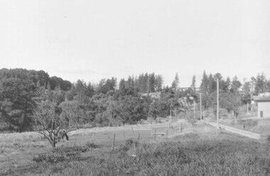
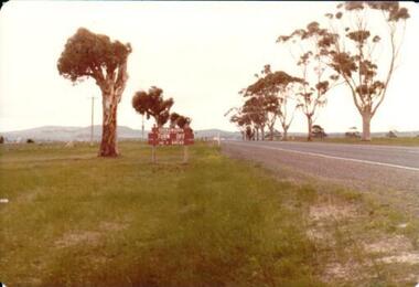 Hume City Civic Collection
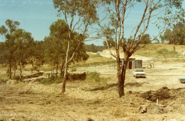
Photograph, 1/08/1980
... Trees are growing on either side of the road and Mt. Holden can be seen across the skyline....Trees are growing on either side of the road and Mt. Holden can be seen across the skyline. Photograph ...On 4th August 1978 the construction of the Goonawarra Estate commenced. The estate was formerly known as the Goonawarra Farm and overlooked the Sunbury town and the Jacksons Creek valley. Plans for the development included a golf course, houses, community and recreational facilities..The golf course opened in 1980 and the housing construction continued throughout the last two decadesd of the twentieth century and into the twenty firsat century.A coloured photograph showing the signpost indicating the entrance to the Goonawarra Estate from Sunbury Road. Trees are growing on either side of the road and Mt. Holden can be seen across the skyline.goona warra golf club, goonawarra farm, goonawarra housing estate, sharkey, robert b., kilkenny homes, australian ideas homes pty.ltd., craftsmen homes., glamor homes, villa bella homes, mt. holden, george evans collection -
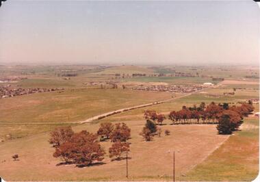 Hume City Civic Collection
Photograph, 1980s
... Road area in the early 1980s. wilson's lane mt. holden bald hill sunbury george evans collection A landscape coloured photograph with rounded corners. It is a panoramic view of Sunbury taken from the southern slopes of Mt. Holden. In the foreground there is a small cluster of trees and in the middle distance there is some evidence of housing development. Bald Hill can be seen on the skyline ...The photograph was taken above Reservoir Road on the lower slopes of Mt. Holden. It is looking south down Wilson's Lane towards some of the early Sunbury developments which grew around the Gap Road area in the early 1980s.A landscape coloured photograph with rounded corners. It is a panoramic view of Sunbury taken from the southern slopes of Mt. Holden. In the foreground there is a small cluster of trees and in the middle distance there is some evidence of housing development. Bald Hill can be seen on the skyline.wilson's lane, mt. holden, bald hill, sunbury, george evans collection