Showing 122 items matching sluice
-
 Linton and District Historical Society Inc
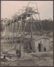
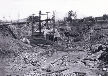
Photograph, Electro Hydraulic Dredge, Snake Valley, 1909
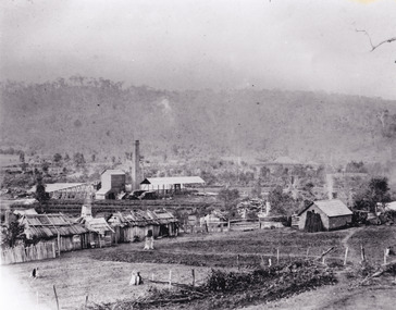
Electro hydraulic dredge Snake Valley 1909. J Mc Bennett, was an engineer back at the main base, at Dawson's dam on the Carngham Road, Between Linton and Snake Valley. These dredges were used for getting gold. The streams of water under high pressure just washed the hills and ground away. This dredge closed down early 1910. 200 H.P. motors were used and 10 in. pumps.Black and white image of three workmen, one beside mining building the other two at dredge pump outlet. Image mounted on dark brown card. Between 1904 and 1911 the Electro Hydraulic Company sought to extract gold in an area north of Linton known as the Hard Hills. By blasting water from high-pressure hoses into the hillsides, soil containing gold was washed out for sluicing. Two gravel pumps in Dawson's Dam pumped the wash through the sluices. Despite considerable investment in expensive equipment, the Company did not have a great deal of success, and the mining operation ceased in 1911.mining, gold, mining equipment, electro hydraulic dredge, dredging, sluicing, dawson's dam, snake valley, miners -
 The Beechworth Burke Museum
Photograph
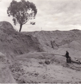
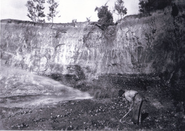
This photograph depicts a man in dark clothing, standing in front of a cut away section of earth. He is undertaking hydraulic sluicing, which involves the use of high powered hoses, in order to cut away the earth which can then be sifted for gold. There is a single tree in the background and the earth contains numerous signs of damage because of the mining. Beechworth become a mining settlement after the discovery of gold in 1852. Gold fever had already spread across Australia's colonies and the American states. Sluicing the landscape for gold, as shown in this photograph, was done by diverting water and washing away the lighter dirt, allowing the gold particles to sift down in to catchments for collection. In Beechworth, there was considerable discontent caused by attempts to restrict water use for sluicing to those with certain 'water rights'. The extensive use of hydraulic sluicing, and the washing away of top soils has continued to impact the surrounds of Beechworth in to the present day. Sluicing as a method for gold mining which was widespread across Victoria during the 1870s. The erosion of the top soil in search of gold has a continuing environmental impact on the landscape and this photograph depicts but one example of this occurring and can provide much information to a researcher interested in understanding the history of gold mining in Victoria. This image of the miner and hose is historically important because it demonstrates the methods of goldmining employed in the later years of the goldrush at Beechworth. It shows how much land is washed away by the use of this technology. The image has good interpretive capacity because it allows researchers to see a different mining technique to what is usually presented. Black and white square photograph on card.reverse: 84-50-3 / 1997 3141 / smdsluicing, goldmining, beechworth, burke museum, miners, gold miners, gold sluicing, environmental impact -
 The Beechworth Burke Museum
Photograph - Photograph - Reproduction
This photograph depicts mining operations within the Beechworth area, in an unidentified valley where sluicing was utilised as a method for extracting gold from the environment. After gold was discovered in the region in 1851, sluicing became a characteristic of gold mining in the region - "Ovens miners carved intricate networks of races" throughout the region - involved the diversion of water in many channels, or water races, which contained inbuilt 'ripple devices' designed to trap gold for later extraction. By 1871, 900 miles of water races had been cut into the Beechworth Mining District. As suggested by the numerous figures involved in labouring along the water race, sluicing was a source of considerable employment within the region. This image is of important historical significance for its ability to convey information about sluicing and the methods used to find gold in the 1850s, and provides clues as to how sluicing and the widespread construction of water ranges changed the environment of the region. This image is important for current research into the history of the Ovens region in Victoria, which played such a prominent role in the early Australian gold mining industry. Therefore, this image has the capacity to be beneficial for research into society and the motivations of those living and working in this region during this period and therefore, has social significance. The Beechworth Burke Museum has additional images relating to gold sluicing and and the mining activities in the area more generally, which can be analysed and studied alongside images like this one.A black and white rectangular photograph printed on matte photographic paperbeechworth, mining, miners, labour, water race, sluicing -
 The Beechworth Burke Museum
Photograph, 1910
This photograph dating to 1910 depicts an open cut sluicing site located in El Dorado captured looking east up the open cut from the number 3 Barge site. Sluicing was undertaken in the area from 1900 to 1942 with some short breaks between these periods. The image depicts a location mined by Cocks Pioneer Gold and Tin Sluicing Company (as recorded on the annotation on the card mount). It portrays open cut rocks with a crevice in the center of the image where the sluicing was being undertaken. There is a small timber structure on the right of the image which could be an entrance to a mine or supports made of wood to prevent a cave in at the open cut site and above the cut rock there is bush. The timber structure has rail tracks on top of the bridge which could suggest the identification of this structure as a mine entrance. The rail tracks were used for little carts which hauled soil from the mine. The Cocks Pioneer Gold and Tin Mines N.L was one of El Dorado's two largest open cut sluicing mines of the 20th Century. The other was named the Cocks El Dorado Gold Dredging Company. The Cocks Pioneer Mines operated from 1901 until 1941 and found a total of 117,378 ounces of Gold and 1,673 tones of tin concentrates over these years. The Cocks company was formed in 1898 and operated until 1941. Open cut sluicing involved the use of high-powered hoses which used the centrifugal sand pump system (known as hydraulic sluicing) which broke down the soil which was then processed for gold and other precious metals. From 1914 , four years after this image was captured, the company reformed to Cocks Pioneer Gold and Tin Mines NL (previously it was known as Cocks Pioneer Sluicing Co) and undertook large scale sluicing operations until 1929 and then 1934-1941. El Dorado is located on Reedy Creek and is surrounded by forested country to the north and east. It is 20 km east of Wangaratta in Victoria's regional north-east. John Cock was the son of a Cornish minor who arrived in El Dorado in 1858. Cock founded his gold and tin mining company which ran successfully for many years in the El Dorado region. It was an open cut sluicing company because of the abandonment of underground mining after this was deemed too dangerous. In 1935 Cock's El Dorado Company commissioned the floating dredge which is still visible in El Dorado today. The dredge was built by the Thompson engineering works, Castlemaine, and weighed over 2,000 tones and today has a place on the Victorian Registers of historic buildings. Interestingly, the name El Dorado does not derive from the gold in the region, but from the Barambogie pastoral run completed by William Baker in 1840-1841. Gold was discovered in El Dorado 1854 but the gold was too deep for individual prospectors to find, it required the use of heavy machinery.The search for gold is ingrained into the history of Victoria and therefore, images like this one which portray an open cut sluicing site can reveal important information for society and technology for the date when the photograph was taken. This image is of important historical significance for its ability to convey information about sluicing and the methods used to find gold in 1910. It also shows a location where sluicing was undertook which provides insight into the impact of sluicing on the environment at a time when it was done. This image is important for current research into the history of El Dorado, a small regional location near Wangaratta in Victoria's North East. Therefore, this image has the capacity to be beneficial for research into society and the motivations of those living and working in this region during this period and therefore, has social significance. The Beechworth Burke Museum has additional images relating to gold sluicing and El Dorado which can be analysed and studied alongside images like this one.Sepia coloured rectangular photograph printed on gloss photographic paper mounted on board.Obverse: COCKS PIONEER Q + T SL CO, N.L. / 1910 / LOOKING EAST UP OPEN CUT / FROM NO3 BARGE SITE / Reverse: 1997 . 2611 / A02611el dorado, north east gold, sluicing, gold sluicing, hydraulic sluicing, 1910, gold and tin mine, open cut mining, mining, gold mining, north-east victoria, beechworth, burke museum -
 The Beechworth Burke Museum
Photograph, 1907-8
The photo from 1907-8 is a sepia print, depicting a small valley with building at base. There are flumes visible above areas of water, trees on hills and a few small cottages on the hillside. Cock's Pioneer Gold & Tin Sluicing Co NZ No 2 Site. The photo was taken of Matthews Gully looking west. Sluicing was undertaken in the area from 1900 to 1942 with some short breaks between these periods. The image depicts a location mined by Cocks Pioneer Gold and Tin Sluicing Company (as recorded on the annotation on the card mount) The Cocks Pioneer Gold and Tin Mines N.L was one of El Dorado's two largest open cut sluicing mines of the 20th Century. The other was named the Cocks El Dorado Gold Dredging Company. The Cocks Pioneer Mines operated from 1901 until 1941 and found a total of 117,378 ounces of Gold and 1,673 tones of tin concentrates over these years. The Cocks company was formed in 1898 and operated until 1941. Open cut sluicing involved the use of high-powered hoses which used the centrifugal sand pump system (known as hydraulic sluicing) which broke down the soil which was then processed for gold and other precious metals. From 1914 , four years after this image was captured, the company reformed to Cocks Pioneer Gold and Tin Mines NL (previously it was known as Cocks Pioneer Sluicing Co) and undertook large scale sluicing operations until 1929 and then 1934-1941. El Dorado is located on Reedy Creek and is surrounded by forested country to the north and east. It is 20 km east of Wangaratta in Victoria's regional north-east. John Cock was the son of a Cornish minor who arrived in El Dorado in 1858. Cock founded his gold and tin mining company which ran successfully for many years in the El Dorado region. It was an open cut sluicing company because of the abandonment of underground mining after this was deemed too dangerous. In 1935 Cock's El Dorado Company commissioned the floating dredge which is still visible in El Dorado today. The dredge was built by the Thompson engineering works, Castlemaine, and weighed over 2,000 tones and today has a place on the Victorian Registers of historic buildings. Interestingly, the name El Dorado does not derive from the gold in the region, but from the Barambogie pastoral run completed by William Baker in 1840-1841. Gold was discovered in El Dorado 1854 but the gold was too deep for individual prospectors to find, it required the use of heavy machinery.The search for gold is ingrained into the history of Victoria and therefore, images like this one which portray an open cut sluicing site can reveal important information for society and technology for the date when the photograph was taken. This image is of important historical significance for its ability to convey information about sluicing and the methods used to find gold in 1910. It also shows a location where sluicing was undertook which provides insight into the impact of sluicing on the environment at a time when it was done. This image is important for current research into the history of El Dorado, a small regional location near Wangaratta in Victoria's North East. Therefore, this image has the capacity to be beneficial for research into society and the motivations of those living and working in this region during this period and therefore, has social significance. The Beechworth Burke Museum has additional images relating to gold sluicing and El Dorado which can be analysed and studied alongside images like this one.Sepia coloured rectangle photograph printed on gloss photographic paper Reverse: 1997. 2613/ A02613/ No2 site/ Matthews Gully/ Cocks Pioneer G&T. ?? Co NZ/ No2 Site looking West/ 1907-8/ (7)sluicing, hydraulic sluicing, 1907, 1908, mining, cock's pioneer gold & tin sluicing co nz, nz, site no 2, matthews gully, west, valley, building, cottages, hillside, trees, water, gold and tin mine -
 Halls Gap & Grampians Historical Society
Photograph - B/W, C 1900
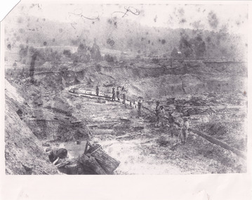
This claim was named "Kangaroo". It had a deep tunnel but produced little gold. The claim was later sold to an Ararat Syndicate which sluiced out the tunnel.Photo of five miners grouped about a trolley at the mouth of a tunnel.mining, mafeking -
 The Beechworth Burke Museum
Photograph, 1920 - 1930
Taken between circa 1920 - 1950 this photograph depicts the open mine in the Three Mile Mine at Barramutha. The mine was an important gold resource and was typically mined using a method known as hydraulic sluicing whereby high powered water jets are used to dislodge rock or move sediment. The remaining water sediment slurry is directed through sluice boxes to remove the gold. The Beechworth mining district was one of six mining districts established by the governor-in-council on 4th of January 1858 under the provisions of An Act for Amending the Laws Relating to the Goldfields (21 Vic no. 32).This photograph shows cultural and research value into the historical methods of hydraulic sluicing in the Beechworth mining disctrict. It also shows the evolution of the mining methods and has potential for understanding future engineering endeavors in the context of victorian mine goldfields.Black and White rectangular photograph printed on matte photographic paper.Reverse: Copied from original on loan from Webb (QLD)/ Donated Nov 2009/ Barnawatha Three Mile Mine c1920-1950 Minehead & Slicing/ Managed by John Weir, Peter Jensen, Jack Cox/ Owned by/ the Plain Bros then Parkinsons/ John worked for Pqarkinsons. three mile creek, three mile goldfields, three mile beechworth, goldfields, #beechworth, hydraulic mining, hydraulic sluice, burke museum -
 The Beechworth Burke Museum
Photograph - Photograph - Reproduction, ca. 1900
This image shows the approach to Beechworth from the south-west via the Newtown Bridge. Numerous early buildings line the road as it bifurcates to become Ford and High Streets on the ridge above Spring Creek and Newtown Falls. The sloping, rocky terrain and water course along the gorge show evidence of the intense mining activity that occurred at the site. The Ovens Gold Rush at Beechworth started when gold was found at Spring Creek in February 1852, prompting an influx of miners from around the world. The population grew over 20,000 by 1857. While the earliest mining at Beechworth was similar to that in other Victorian goldfields like Ballarat and Bendigo, Beechworth is notable for its use of hydraulic sluicing as a major method of removing wash-dirt. Hydraulic sluicing employs high pressure jets of water to blast away large areas of earth and wash it down to be run through a sluice box. Gold gets caught in the sluice and the remaining slurry is washed away. This method of mining is extremely effective but causes significant environmental impacts and damage to waterways. Large water quantities were required for large-scale sluicing, and the long water races and deep tailraces that were constructed in the Beechworth area in the nineteenth century are nonetheless considered feats of engineering. The site in the photograph is associated with the Rocky Mountain Mining Company who constructed an eight hundred meter tunnel under the township between 1876-1880 to reduce water levels at Spring Creek, which had been subject to diversions since the earliest days of alluvial mining. Over four million ounces of gold (115 tones) were found at Beechworth between 1852 and 1868, and the wealth from the gold rushes built Beechworth and the nationally significant buildings that remain standing today.This image shows the early development of the Beechworth township above Spring Creek, where gold was discovered in 1852. Evidence of hydraulic sluicing, a uniquely predominant method at Beechworth, and water-works engineering are present in the landscape. By the 1870s, alluvial gold deposits were depleted and increasingly complex engineering was required so deeper shafts could reach bedrock. This image is significant for understanding changes to the landscape and the evolution of mining methods and engineering practices related to the extensive construction, manipulation and management of water networks. The shift from smaller scale alluvial mining to larger company dominance in the mining industry has implications for understanding wider social, economic, political and industrial changes in the region of Beechworth and within the context of the Victorian Gold Rush more broadly. A black and white rectangular reproduction photograph printed on photographic paper. burke museum, beechworth museum, beechworth, gold fields, gold rush, victorian gold rush, hydraulic sluicing, rocky mountain mining company, spring creek, netwown falls, mining tunnels, water races, tailraces, colonial australia, australian gold rushes, mining technology, beechworth historic district, indigo gold trail, migration, indigo shire, gold mining, gold mining history -
 The Beechworth Burke Museum
Photograph
This photograph dates to 1899, towards the end of the gold rush in the Mopoke Gully area. A slurry of rocks after they have been broken up is depicted, and this is part of the hydraulic sluicing mining process. Four men are relaxing under a wooden structure, with a fifth bearded man standing near a stone wall. This photograph interestingly contains dogs alongside the miners. While dogs have been recorded as deterrents to thieves in the Victorian goldfields, these dogs appear as companions to these men. Mopoke Gully mines came under the 'Fryer's Creek' division of the Castlemaine District during the Gold Rush. After the Gold Rush began in Victoria with the discovery of gold at Ballarat in 1851, Gold was found in Castlemaine by December of that year. 20,000 diggers were spread across the Castlemaine region, and the area was yielding about 23,000 ounces of gold per week. Mopoke Gully was the site of the Mopoke Gully Water Wheel, operating under the Bendigo and Fryers Goldmining Company from 1887 until 1900. This Water Wheel was used in the gold mining technique of 'sluicing'. Hydraulic sluicing uses high pressure water jets to blast away the earth, which runs through a sluice box, catching the gold with all remaining slurry washing away. Hydraulicking is the process of breaking up the rocks and suspending it in a slurry. This Water Wheel was built the same year as the more famous 'Chewton Water Wheel', but was smaller in diameter (60ft as opposed to Chewton's 72ft). The Mopoke Water Wheel ruins are quite intact today, and are a registered archaeological site.The search for gold is ingrained into the history of Victoria and therefore, images like this one which portray a sluicing site can reveal important information for society and technology for the date when the photograph was taken. This image is of important historical significance for its ability to convey information about sluicing and the methods used to find gold in 1899. It also shows a location where sluicing was undertook which provides insight into the impact of sluicing on the environment at a time when it was done. This photograph reveals important information on the use of dogs on Victorian goldfields in 1899. Dogs were used both as companions, such as this photograph depicts, as well as deterrents to thieves. Sepia coloured rectangular photograph printed on gloss photographic paper mounted on card.Obverse: Reverse: A02497/ 1997.2497/ 'Good/ Luck/ Mine'/ Morepork/ Gully/ Mrs Joyce/ Bright/ Tunnel/ 800 ft/ 1899. beechworth, burke museum, gold, gold mining, 1899, castlemaine, mopoke gully, good luck mine, fryer's creek, gold rush, victorian gold rush, water wheel, sluicing, chewton, slurry -
 The Beechworth Burke Museum
Photograph, Circa 1920 - 1950
Taken between circa 1920 - 1950 this photograph depicts a man dressed in dark trousers, a white long sleeved shirt and broad-brimmed workers hat digging around in the Three Mile Mine at Barramutha. The mine was an important gold resource and was typically mined using a method known as hydraulic sluicing whereby high powered water jets are used to dislodge rock or move sediment. The remaining water sediment slurry is directed through sluice boxes to remove the gold. The Beechworth mining district was one of six mining districts established by the governor-in-council on 4th of January 1858 under the provisions of An Act for Amending the Laws Relating to the Goldfields (21 Vic no. 32). This photograph shows historic and research value into the historical methods of hydraulic sluicing in the Beechworth mining disctrict. It also shows the evolution of the mining methods and has potential for understanding future engineering endeavors in the context of victorian mine goldfields. Black and white rectangular photograph printed on matte photographic paper.Reverse: 7597.3/ Copied from original on loan from Webb (QLD)/ Donated Nov 2009/ Barnawatha Three Mile Mine 1920-1950/ Owned by Plain Bros then Parkinsons/ Managed by John Weir, Peter Jenson, Jack Cox/ Slicing. three mile creek, three mile goldfields, three mile beechworth, goldfields, #beechworth, hydraulic mining, hydraulic sluice, burke museum -
 The Beechworth Burke Museum
Photograph, 1910 - 1911
This photograph depicts Cock's Pioneer G & T Sluicing site No. 4 in El Dorado. Looking eastwards, the photo captures a wooden and tin building with various mining equipment strewn in the foreground. Underneath the verandah, figures can be seen. These are believed to be a Mr. Hollister (left), Mrs. Breustedt (4th from left), children Min and Chris Breustedt, and Kate Timmons holding a girl's hand. The Cocks Pioneer Gold and Tin Mines N.L was one of El Dorado's two largest open-cut sluicing mines of the 20th Century. The other was named the Cocks El Dorado Gold Dredging Company. The Cocks Pioneer Mines operated from 1901 until 1941 and found a total of 117,378 ounces of Gold and 1,673 tones of tin concentrates over these years. The Cocks company was formed in 1898 and operated until 1941. Open cut sluicing involved the use of high-powered hoses which used the centrifugal sand pump system (known as hydraulic sluicing) which broke down the soil which was then processed for gold and other precious metals. From 1914, four years after this image was captured, the company reformed to Cocks Pioneer Gold and Tin Mines NL (previously it was known as Cocks Pioneer Sluicing Co) and undertook large-scale sluicing operations until 1929 and then 1934-1941. The Cocks Pioneer was an extremely successful mining company during the 20th century. In the Annual Report of the Secretary for Mines for the year 1915, the Cocks Pioneer was the largest producer of gold and tin collecting 5,535 ozs. of gold and £7,500 of tin. Twenty years later in 1935, Cocks Pioneer was still one of the most profitable mines in Victoria, ranking as the second-highest dividend paying mine. The company produced a total of 3,650 kg of gold. El Dorado is located on Reedy Creek and is surrounded by forested country to the north and east. It is 20 km east of Wangaratta in Victoria's regional northeast. John Cock was the son of a Cornish miner who arrived in El Dorado in 1858. Cock founded his gold and tin mining company which ran successfully for many years in the El Dorado region. It was an open-cut sluicing company because of the abandonment of underground mining after this was deemed too dangerous. In 1935 Cock's El Dorado Company commissioned the floating dredge which is still visible in El Dorado today. The dredge was built by the Thompson engineering works, Castlemaine, and weighed over 2,000 tones and today has a place on the Victorian Registers of historic buildings. Interestingly, the name El Dorado does not derive from the gold in the region, but from the Barambogie pastoral run completed by William Baker in 1840-1841. Gold was discovered in El Dorado in 1854 but the gold was too deep for individual prospectors to find, it required the use of heavy machinery.The search for gold is ingrained into the history of Victoria and therefore, images like this one which portray an open cut sluicing site can reveal important information for society and technology for the date when the photograph was taken. This image is of important historical significance for its ability to convey information about sluicing and the methods used to find gold in 1910. It also shows a location where sluicing was undertook which provides insight into the impact of sluicing on the environment at a time when it was done. This image is important for current research into the history of El Dorado, a small regional location near Wangaratta in Victoria's North East. Therefore, this image has the capacity to be beneficial for research into society and the motivations of those living and working in this region during this period and therefore, has social significance. The Beechworth Burke Museum has additional images relating to gold sluicing and El Dorado which can be analysed and studied alongside images like this one.A black and white copy of a sepia coloured rectangular photograph printed on matte photographic paper mounted on boardObverse: COCKS PIONEER G + T SL CO, N.L. / 1910 - 11 / NO 4 SITE LOOKING EAST / 4 Reverse: 1997.2508 / AUG 29 1909cocks pioneer gold and tin sluicing company, el dorado, mining, sluicing, hydraulic mining, hollister, breustedt, timmons, gold, tin, gold rush, victoria -
 The Beechworth Burke Museum
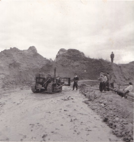
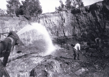
Photograph
The photograph depicts a mine cut with a tractor. Water is being used to sluice the front of the tractor, possibly to separate any gold that may have been picked up from the earth. A few people watch the demonstration. Water was a significant part of gold mining in the Beechworth area and miners used a method known as 'hydraulic sluicing'. Due to the amount of water required, many water races were constructed throughout the Beechworth Mining District. These were cut through solid rock and are an example of engineering achievement. Water usage in the area put Beechworth at the heart of water policy, with many firsts for Victorian colonial goldfield water management being established in the Beechworth Mining District. This photograph is significant as it depicts the use of water in gold mining in Beechworth. Beechworth was notable for it's use of water in mining.Black and white square photograph (portrait orientation) printed on matte photographic paper.Reverse: SW-50-2 / 1997 31136 / unreadable pencil markingssluicing, gold mining, mining, hydraulic sluice, hydraulic sluicing, beechworth mining district -
 The Beechworth Burke Museum
Photograph, 1920 - 1930
Taken between circa 1920 - 1930 this photograph depicts a Hydraulic water jet in the foreground and a man dressed in dark trousers, a white long sleeved shirt and broad-brimmed workers hat digging around in the Three Mile Mine at Barramutha. The mine was an important gold resource and was typically mined using a method known as hydraulic sluicing whereby high powered water jets are used to dislodge rock or move sediment. The remaining water sediment slurry is directed through sluice boxes to remove the gold. The Beechworth mining district was one of six mining districts established by the governor-in-council on 4th of January 1858 under the provisions of An Act for Amending the Laws Relating to the Goldfields (21 Vic no. 32).This photograph shows cultural and research value into the historical methods of hydraulic sluicing in the Beechworth mining disctrict. It also shows the evolution of the mining methods and has potential for understanding future engineering endeavors in the context of victorian mine goldfields.Black and White rectangular photograph printed on matte photographic paper. Reverse: Copied from original on loan from Webb (QLD)/ Donated Nov 2009/ Barnawatha Three Mile Mine c1920-1950/ Owned by Plain Bros then Parkinsons/ Managed by John Weir, Peter Jenson, Jack Cox/ Slicing. three mile creek, three mile goldfields, three mile beechworth, goldfields, #beechworth, hydraulic mining, hydraulic sluice, burke museum -
 The Beechworth Burke Museum
Photograph
This photograph dates to 1899, towards the end of the gold rush in the Mopoke Gully area. A large opening to a mine can be seen behind the men in the photograph, with a wheeled cart on a track leading to the men's position, where the soil and rocks have been hauled away. This photograph interestingly contains dogs alongside the miners. While dogs have been recorded as deterrents to thieves in the Victorian goldfields, these dogs appear as companions to these men. Mopoke Gully mines came under the 'Fryer's Creek' division of the Castlemaine District during the Gold Rush. After the Gold Rush began in Victoria with the discovery of gold at Ballarat in 1851, Gold was found in Castlemaine by December of that year. 20,000 diggers were spread across the Castlemaine region, and the area was yielding about 23,000 ounces of gold per week. Mopoke Gully was the site of the Mopoke Gully Water Wheel, operating under the Bendigo and Fryers Goldmining Company from 1887 until 1900. This Water Wheel was used in the gold mining technique of 'sluicing'. Hydraulic sluicing uses high pressure water jets to blast away the earth, which runs through a sluice box, catching the gold with all remaining slurry washing away. This Water Wheel was built the same year as the more famous 'Chewton Water Wheel', but was smaller in diameter (60ft as opposed to Chewton's 72ft). The Mopoke Water Wheel ruins are quite intact today, and are a registered archaeological site. The search for gold is ingrained into the history of Victoria and therefore, images like this one can reveal important information for society and technology for the date when the photograph was taken. This image is of important historical significance for its ability to convey information about sluicing and the methods used to find gold in 1899. This photograph reveals important information on the use of dogs on Victorian goldfields in 1899. Dogs were used both as companions, such as this photograph depicts, as well as deterrents to thieves. Sepia coloured rectangular photograph printed on gloss photographic paper mounted on card. Obverse: Williams/ Good/ Luck Reverse: A02498/ 1997. 2498/ Good Luck/ Mine/ 1899/ Mopoke. beechworth, burke museum, gold, gold mining, 1899, castlemaine, mopoke gully, good luck mine, fryer's creek, gold rush, victorian gold rush, water wheel, sluicing, chewton -
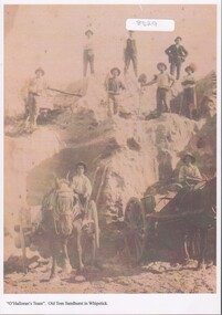 Bendigo Historical Society Inc.
Photograph - Sand mining at the Whipstick
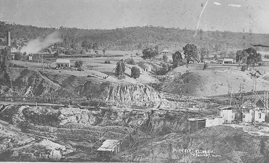
Old Tom mine included quartz mining and open cut mining. Today the remains of the battery site, cyanide plant, hydrolic sluicing and a 1930's puddler can be seen. It was operating in August 1874 and was taken over in 1897 by an English syndicate, J. R. Syndicate. By 1899 the mine had reached 500 feet in depth . The mine closed c. 1901.8529 Sand mining at Old Tom mine the Whipstick, Eaglehawk. O'Halloran's team of nine men and two horses and carts. Two men with horse and carts; and seven men on top of the sand deposit. A4 copy of 1513 Box 25sand mining, whipstick, old tom mine -
 The Beechworth Burke Museum
Photograph, est. 1860-1875
In 1875, the Rocky Mountain Extended Gold Sluicing Company Ltd was created, utilising the previous Rocky Mountain claim for the area near Lake Sambell. The company employed A.L Martin to survey an area for a tunnel underneath Beechworth and Johnson Stephens to dig it. The tunnel was built at a rate of 40 feet a month and eventually measured 800 metres. The tunnel was a true accomplishment both in the present and during the 19th century. It was considered to be a marvelous engineering feat. Beechworth is renowned for its hydraulic sluice method of mining. This involved soil being exposed to torrents of water from high-pressure hoses. From 1876 until its closure in 1921, the mine produced an astounding 47,926 ozs of gold. Companies like this were the source of income for many Chinese gold-diggers who sought to make their fortune on the goldfields of Beechworth. During the height of the rush, the town had around 7,000 Chinese inhabitants living on the outskirts of town as they were not permitted to live within Beechworth itself.The search for gold is ingrained into the history of Victoria and therefore, images like this one which portrays an open-cut sluicing site can reveal important information for society and technology for the date when the photograph was taken. This image is of important historical significance for its ability to convey information about sluicing and the methods used to find gold in 1910. It also shows a location where sluicing was undertaken which provides insight into the impact of sluicing on the environment at a time when it was done. This image of the Rocky Mountain mine is historically significant as the mining complex is now non-existent, with the only remains being the tunnel built in 1880 by the company, which was considered one of the greatest engineering feats of the time. The image also provides a first-hand look into the social and cultural networks at play during the 19th century with racial segregation of the Chinese at the 'Chinese Camp', as well as an insight into Beechworth's origins during the Gold Rush.A sepia rectangular photograph printed on matte photographic paper as a postcardReverse: Historic Beechworth / 7792.1 / ROCKY MOUNTAIN MINE / Viewed from the “Chinese Camp”, shown partly in the foreground, we see the central plant of the famous Rocky Mountain Mining Company. This extensive complex, of which nothing remains, was situated between Silver Creek and the present Lake Sambell area. The company was responsible for a tunnel cut through solid bedrock underneath the town of Beechworth and surfacing near the keystone bridge on the Wangaratta side. Completed in 1880 it was declared to be one of the greatest engineering feats in Australia. The tunnel is still basically intact today. / Series by Wooragee Graphics: Historic Beechworth. / COPYRIGHT BURKE MUSEUM / No.72 beechworth, rocky mountain mine, sluicing, gold rush, mining, gold -
 El Dorado Museum Association Inc.
Photograph - Digital Image
Riffle Boards on Barge, c1934. In sluicing, riffles are used to trap heavier gold particles as water washes over them. Cocks Pioneer Electric Gold & Tin Mine Company was formed in 1899. The company's first power station, located at the eastern end of the valley began operating with its 340 Kilowatt steam-powered generator. By 1909, from 2 500 000 cubic yards worked, reported recovery was 17 284 ounces of gold and 224 tons of tin ore. By 1909, Cocks Pioneer’s power plant had become inadequate and uneconomical. The barge was floated downstream about a mile, but lost time caused the operations to cease. Following testing, a new mine was established by diverting Reid's Creek at a cost of £25 000. Settling dams were built, one of which held 1 935 900 cubic feet. Sold earth banks, built against a wall of stringy bark saplings constructed and laced with vertical props, were built. In 1914, the company was reformed as Cock’s Pioneer Gold and Tin Mines NL, another power station was constructed at the western end of the township, near the junction of Clear and Reid's Creeks. From 6,800,000 cubic yards of material processed, the returns were 64 397 ounces of gold and 855 ton of tin. Cocks Pioneer mine then moved the barge downs stream and continued sluicing. In 1929 Cocks Pioneer Electric Gold and Tin Mining Company ceased operations due to a drop in values. Cock’s Pioneer Gold and Tin Mines NL carried on large-scale hydraulic sluicing operations until 1941. mines, mining, gold, gold mining, barge, riffles, sluicing, men, cocks pioneer, el dorado, eldorado -
 The Beechworth Burke Museum
Photograph - Photograph - Reproduction, 1890-1900
The photograph appears to depict the of the entrance to the Rocky Mountain Tunnel. The Rocky Mountain Tunnel runs from opening of the tunnel, underneath the Beechworth town, to the Gorge. This tunnel drained the excess water from the upper Spring Creek Goldfield to allow for mining access in the area. The Rocky Mountain Co. blasted through the granite rock to create the original 400ft-long tunnel in 1859, but between 1867 and 1871, the Rocky Mountain Gold Sluicing Co. widened and extended it. At its completion, it measured 14ft deep, 6ft wide, and almost half a mile long. The mining surveyor at Beechworth called it 'without doubt, the greatest undertaking of the kind in the colony'. When the company became the Rocky Mountain Extended Gold Sluicing Co. in the mid-1870s, they continued the tunnelling work. The work was reportedly vital to mining being able to continue at Beechworth and may have established world records in tunnelling through hard rock. The entrance at the Gorge side of the tunnel can be seen from the Beechworth Gorge Walk. The tunnel continues to be an outfall drain for the lake and the town.The search for gold is ingrained into the history of Victoria and therefore, images like this one which portray an open cut sluicing site can reveal important information for society and technology for the date when the photograph was taken. This image is of important historical significance for its ability to convey information about sluicing and the methods used to find gold in the late 1800s and early 1900s. It also shows a location where sluicing was undertook which provides insight into the impact of sluicing on the environment at a time when it was done. The Burke Museum is home to a substantial collection of Australian mining photographs which can be used to gain a deeper understanding into life on the gold fields, technology used in mining, the miners themselves and the impact of the gold digging on the environment.A black and white rectangular reproduced photograph printed on matte photographic paper.7814beechworth, beechworth museum, burke museum, australian museum, mining, rocky mountain mining co., rocky mountain mining company, mine, mining company, rocky mountain mine, mine entrance, rocky mountain, gold, gold mining -
 The Beechworth Burke Museum
Photograph - Photograph - Reproduction
The photograph is a reproduction of a postcard from the Rocky Mountain Mining Company. In 1875, the Rocky Mountain Extended Gold Sluicing Company Ltd was created, utilising the previous Rocky Mountain claim for the area near Lake Sambell. The company employed A.L Martin to survey an area for a tunnel underneath Beechworth and Johnson Stephens to dig it. The tunnel was built at a rate of 40 feet a month and eventually measured 800 metres. The tunnel was a true accomplishment both in the present and during the 19th century. It was considered to be a marvelous engineering feat. Beechworth is renowned for its hydraulic sluice method of mining. This involved soil being exposed to torrents of water from high-pressure hoses. From 1876 until its closure in 1921, the mine produced an astounding 47,926 ozs of gold. Companies like this were the source of income for many Chinese gold-diggers who sought to make their fortune on the goldfields of Beechworth. During the height of the rush, the town had around 7,000 Chinese inhabitants living on the outskirts of town as they were not permitted to live within Beechworth itself.This image of the Rocky Mountain mine is historically significant as the mining complex is now non-existent, with the only remains being the tunnel built in 1880 by the company, which was considered one of the greatest engineering feats of the time. The image also provides a first-hand look into the social and cultural networks at play during the 19th century with racial segregation of the Chinese at the 'Chinese Camp', as well as an insight into Beechworth's origins during the Gold Rush.Black and white rectangular reproduced photograph printed on paperbeechworth, rocky mountain mine, sluicing, gold rush, mining, gold -
 The Beechworth Burke Museum
Photograph - Photograph - Reproduction, W. D. Gibbon, Early 1900s
This photograph was taken in 1911 at Three Mile Creek, about five kilometers south of Beechworth town. Significant digging took place at this location from late 1855, which led to a flood of workers and stores to follow, though daily earnings were slim compared to the nearby Woolshed site. This remained the case even after workers at Three Mile Creek attempted to protest around Beechworth during an election in November 1855. Three Mile Creek was one of seven significant divisions of the Beechworth Mining District formalised by the Governor-in-Council in 1858, though by the time this photograph was taken, the boundaries of the original seven districts had shifted to create seventeen divisions. The Three Mile Goldfields was a site of rich alluvial gold deposits located about 5km south of Beechworth in Victoria. Today, the location of this gold deposit is called Baarmutha. It was a popular area for gold mining in the 1850s but became largely abandoned by the following decade. In 1865, a man named John Pund (a man second from the left in the back row of this photograph shares this surname) recognized that the area could be potentially rich if a better water supply could be obtained. He secured a 15 year license with three other miners. Within the next five years, these men had constructed 19 km of water race going from Upper Nine Mile Creek to Three Mile Creek. By 1881, these four men had delivered 950,000 gallons to the Three Mile Sluicing area which is depicted in this photograph. Pund would later go into partnership with John Alston Wallace who would become owner of the Star Hotel in Beechworth. The Three Mile sluicing location continued to be operational until 1950. The eleven miners in this photograph are: Back row: Led Guthrie, P. Pund, F. Beel, [Unknown] Miller Front row: Paddy McNamara, J. King, W. Beel, [Unknown] Garland, J. Clarke, J. Ryan, H. Bartsh In the background of the photograph is a huge dirt wall that appears to suffer damage caused by hydraulic sluicing. Hydraulic sluicing is a specialised mining technique that involves directing high pressure water flows at dirt to uncover gold. The technique played a significant role in shaping Beechworth's landscape during the gold rush to create the topography seen today.The search for gold is ingrained into the history of Victoria and therefore, images like this one which portray an open cut sluicing site can reveal important information for society and technology for the date when the photograph was taken. This image is of important historical significance for its ability to convey information about sluicing and the methods used to find gold in the late 1800s and early 1900s. It also shows a location where sluicing was undertook which provides insight into the impact of sluicing on the environment at a time when it was done. Images, like this one, of Australian gold rush history can reveal important information about the social and environmental impact of this period. This image depicts diggers standing in a mining location and therefore, this image has the capacity to reveal or support significant information for researchers studying the fashion and social status of diggers in Australia in approximately 1911. It can also provide information on the landscape of Australia in this period and the impact of mining for gold on both society and the Australian landscape. The Burke Museum is home to a substantial collection of Australian mining photographs which can be used to gain a deeper understanding into life on the gold fields, technology used in mining, the miners themselves and the impact of the gold digging on the environment.Black and white / sepia rectangular reproduced photograph printed on glossy photographic paper mounted on board.beechworth, beechworth museum, mining, mining team, three mile creek, sluicing, hydraulic sluicing, photography, gold sluicing, gold mining, pund mining -
 Halls Gap & Grampians Historical Society
Photograph - Sepia, C 1900
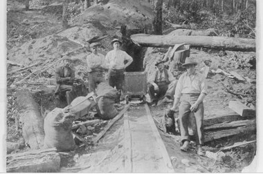
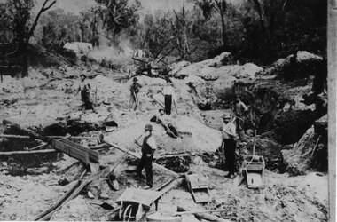
Horton's Reward Claim. This group of miners also worked another area called 'The Heather Bell" approx. 200 yards further up the gully. About half a pennyweight to the dish is obtained from the wash near the creek. They are panning off 3 dwts per day off one man's ground. This claim is about the best fitted up on the field. It is worked with a sluice box with iron ripples and feeder to match. The latter is a great advantage as there is a great fall below the claim for the tailings.Photo shows seven men working a goldfield using shovels and picks.mining, mount william, people -
 Federation University Historical Collection
Booklet, Ballarat School of Mines Student's Magazine, Second Term, 1907
Table of contents: Editorial, Notes on a sluicing scheme and plant, A trip through Eastern Gippsland, Rapid volumetric method for the estimation of phosphoric acid, The making potassium bromate, Engines for electrical work, Round the common fires and in the corridors, Brief notes on the installation and management of the high speed engines with special reference to the Belliss-Morcom engine, Sporting notes, Football, Sporting pars, News and notes, Electric furnaces, Patents, papers or work of former students, Notes on rope gearing, Answers to correspondents, Past students, Correspondence, Editorial notes.Green coloured booklet of 28 pages.ballarat school of mines, students' magazine, norman buley, ernest w. trend, beaumont, buley, charles, elliott, crossley, robin, pearce,, stanger-leathes, treloar, coulter, bieske, davenport, seward, clinton, ditchburn, dawson, campbell, past students, j. h. crittenden, adam mortan, bob allen, r. g. todd, w. wallace, arthur s. coyte, f. stewart, herbert coombes, t. phillipson, alf. a. booth, charles bailey, g. duncan, w. cairncross, j. richardson,, w. kennedy, c. m. harris, hubert f. hall, k. byron moore, w. white -
 Federation University Historical Collection
Book, Railway Practice: a collection of working plans and practical details of construction in the public works of the most celebrated engineers, 1847 (exact)
A green cloth hard cover book. Title and author's name are engraved in gold on spine. This is the 3rd edition, first series with black and white illustrations. It describes the engineering practices of the early days of British railroads. The book includes (series 1 to 4)and it contains, roads, tramroads and railroads, bridges, aqueducts, viaducts, wharfs, warehouses, roofs, and sheds, canals, locks, sluices, & the various works on rivers, streams, etc., harbours, docks, piers and jetties, tunnels, cuttings and embankments, the several works connected with the drainage of marshes, marine sands, and the irrigation of land, water-works, gas-works, water-wheels, mills, engines.civil engineering, railway practice, rail constructions, s c brees, western railway great britain, public works, railroads, canals, s.c. brees, samuel brees, samuel charles brees -
 El Dorado Museum Association Inc.
Photograph (item) - Digital Image
Cocks Pioneer Electric Gold & Tin Mine Company was formed in 1899. The company's first power station, located at the eastern end of the valley began operating with its 340 Kilowatt steam-powered generator. By 1909, from 2,500,000 cubic yards worked, reported recovery was 17,284 ounces of gold and 224 tons of tin ore. By 1909, Cocks Pioneer’s power plant had become inadequate and uneconomical. The barge was floated downstream about a mile, but lost time caused the operations to cease. Following testing, a new mine was established by diverting Reid's Creek at a cost of £25 000. Settling dams were built, one of which held 1,935,900 cubic feet. Sold earth banks, built against a wall of stringy bark saplings constructed and laced with vertical props, were built. In 1914, the company was reformed as Cock’s Pioneer Gold and Tin Mines NL, another power station was constructed at the western end of the township, near the junction of Clear and Reid's Creeks. From 6,800,000 cubic yards of material processed, the returns were 64,397 ounces of gold and 855 ton of tin. Cocks Pioneer mine then moved the barge downs stream and continued sluicing. In 1929 Cocks Pioneer Electric Gold and Tin Mining Company ceased operations due to a drop in values. Cock’s Pioneer Gold and Tin Mines NL carried on large-scale hydraulic sluicing operations until 1941. Handwritten across photograph: "PIONEER" - ELDORADO / F FOXCROFT PHOTO.mining, mines, gold, tin, gold mining, tin mining, sluicing, cocks pioneer, el dorado, eldorado -
 Federation University Historical Collection
Booklet, Ballarat School of Mines, Student Magazine, First Term, 1908
Table of Contents: The location and pegging of a tramway route, The unity of things, Students' third annual dinner, The transmission of power by rope driving, Visit to the Briseis main and new brothers home, School of Mines' sports committee, School of Mines' magazine committee, Diabolo, Limericks sluiced at Snake Valley, Obituary, Hints to the inexperienced, Fossilistic love, Past students, Some bunsen memories, Quaint and curious coincidences, Notes on analytical chemistry, New students, News and notes, Students' library, Sports and pastimes, School of Mines' annual dinner, Correspondence, Answers to correspondents, Editorial notes. Images.Booklet of 26 pages.pegging a tramway route, transmission of power by rope driving, briseis main and new brothers home, diabolo, snake valley, obituary, analytical chemistry, students' library, john brittain, a. e. c. kerr, w. smith, l. seward, leslie coulter, t. williams, f. treloar, whitington, hart, murphy, o. w. williams, l. knight, w. kingston, g. w. sides, w. gelard, w. t. sayer, s. r. white, a. c. hesselmann, r. j. moore, r. g. walker, j. a. peart, newton g. king, w. e. eyres, g.h davenport, a. d. r. galloway, j. e. b. crossley, j. smart, h. hylton, j. blayney, t. lennon, h. s. sheppard, p. c. osbourne, c.w. nash, les smith, w. b. tucker, c. w. white, a. j. robin, h. f. owen, l. a. westcott, e. m. boyer, ernie strick, isadore wittowski, m. tyler, h. m. conran, h. g. conran, h. g. cornell, l. j. middleton, j. d. orr, j. r. blight, w. g. taylor, l. hall, c. bult, g. o. ramsay, o. w. williams, stanley r. heron, john a. grant, william t. sayer, frederick l. treloar, patrick s. anderson, robert mitchell, frederick j. martell -
![View of Sailor’s Creek Bridge / [by] Nicholas Caire, circa 1876](https://victoriancollections.net.au/media/collectors/550653872162f11fb04854aa/items/577b5b7ed0cdd10948d14ae1/item-media/577b5be9d0cdd10948d196a2/item-fit-380x285.jpg) Kew Historical Society Inc
Kew Historical Society IncPhotograph, Anglo-Australasian Photographic Company, View of Sailor’s Creek Bridge, c.1876
Nicholas Caire was born on Guernsey in the Channel Islands in 1837. He arrived in Adelaide with his parents in about 1860. In 1867, following photographic journeys in Gippsland, he opened a studio in Adelaide. From 1870 to 1876 he lived and worked in Talbot in Central Victoria. In 1876 he purchased T. F. Chuck's studios in the Royal Arcade Melbourne. In 1885, following the introduction of dry plate photography, he began a series of landscape series, which were commercially successful. As a photographer, he travelled extensively through Victoria, photographing places few of his contemporaries had previously seen. He died in 1918. Reference: Jack Cato, 'Caire, Nicholas John (1837–1918)', Australian Dictionary of Biography.An original, rare photograph from the series 'Views of Victoria: General Series' by the photographer, Nicholas Caire (1837-1918). The series of 60 photographs that comprise the series was issued c. 1876 and reinforced a neo-Romantic view of the Australian landscape to which a growing nationalist movement would respond. Nicholas Caire was active as a photographer in Australia from 1858 until his death in 1918. His vision of the Australian bush and pioneer life had a counterpart in the works of Henry Lawson and other nationalist poets, authors and painters.Views of Victoria (General Series) No.31 / ‘View of Sailor’s Creek Bridge’ / Albumen silver photograph mounted on boardOn Reverse" ‘Sailor’s Creek as situated in the Jim Crow Ranges, which Range forms a portion of the Great Dividing Range of Mountains in Victoria. These hills contain many romantic spots. The one which forms the subject of the present illustration is a view of the Bridge which spans the Creek. Gold has been found throughout the course of the bed of this Creek in payable quantities. The diggers, as may be seen in the photograph, have constructed sluices in the side of the embankment for the purpose of washing the fine gold contained in the wash-dirt.’nicholas caire (1837-1918), sailor's creek (vic), gold mining (vic) -
 El Dorado Museum Association Inc.
Photograph (item) - Digital Image
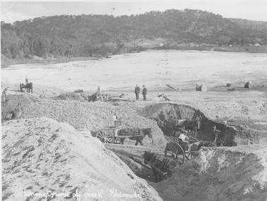
Altering course of Reedy Creek, El Dorado. Cocks Pioneer Electric Gold & Tin Mine Company was formed in 1899. The company's first power station, located at the eastern end of the valley began operating with its 340 Kilowatt steam-powered generator. By 1909, from 2,500,000 cubic yards worked, reported recovery was 17,284 ounces of gold and 224 tons of tin ore. By 1909, Cocks Pioneer’s power plant had become inadequate and uneconomical. The barge was floated downstream about a mile, but lost time caused the operations to cease. Following testing, a new mine was established by diverting Reid's Creek at a cost of £25 000. Settling dams were built, one of which held 1,935,900 cubic feet. Sold earth banks, built against a wall of stringy bark saplings constructed and laced with vertical props, were built. In 1914, the company was reformed as Cock’s Pioneer Gold and Tin Mines NL, another power station was constructed at the western end of the township, near the junction of Clear and Reid's Creeks. From 6,800,000 cubic yards of material processed, the returns were 64,397 ounces of gold and 855 ton of tin. Cocks Pioneer mine then moved the barge downs stream and continued sluicing. In 1929 Cocks Pioneer Electric Gold and Tin Mining Company ceased operations due to a drop in values. Cock’s Pioneer Gold and Tin Mines NL carried on large-scale hydraulic sluicing operations until 1941. Handwritten across the front: 'Altering course of creek. Eldorado'mining, gold, tin, sluicing, reedy creek, cocks pioneer, el dorado, eldorado, men, horses -
 El Dorado Museum Association Inc.
Photograph (item) - Digital Image
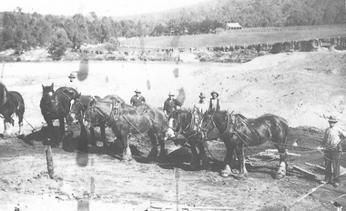
Horse team , Cocks Pioneer Cocks Pioneer Electric Gold & Tin Mine Company was formed in 1899. The company's first power station, located at the eastern end of the valley began operating with its 340 Kilowatt steam-powered generator. By 1909, from 2,500,000 cubic yards worked, reported recovery was 17 284 ounces of gold and 224 tons of tin ore. By 1909, Cocks Pioneer’s power plant had become inadequate and uneconomical. The barge was floated downstream about a mile, but lost time caused the operations to cease. Following testing, a new mine was established by diverting Reid's Creek at a cost of £25,000. Settling dams were built, one of which held 1,935,900 cubic feet. Sold earth banks, built against a wall of stringy bark saplings constructed and laced with vertical props, were built. In 1914, the company was reformed as Cock’s Pioneer Gold and Tin Mines NL, another power station was constructed at the western end of the township, near the junction of Clear and Reid's Creeks. From 6,800,000 cubic yards of material processed, the returns were 64,397 ounces of gold and 855 ton of tin. Cocks Pioneer mine then moved the barge downs stream and continued sluicing. In 1929 Cocks Pioneer Electric Gold and Tin Mining Company ceased operations due to a drop in values. Cock’s Pioneer Gold and Tin Mines NL carried on large-scale hydraulic sluicing operations until 1941. mining, gold, tin, sluicing, men, cocks pioneer, el dorado, eldorado, horses, gold mining, tin mining -
 El Dorado Museum Association Inc.
Photograph (item) - Digital Image
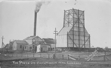
Cocks Pioneer Mine El Dorado, Power Station No. 2 was established in 1914 and located near junction of Reid's and Clear Creeks, Byawatha. Cocks Pioneer Electric Gold & Tin Mine Company was formed in 1899. The company's first power station, located at the eastern end of the valley began operating with its 340 Kilowatt steam-powered generator. By 1909, from 2,500,000 cubic yards worked, reported recovery was 17,284 ounces of gold and 224 tons of tin ore. By 1909, Cocks Pioneer’s power plant had become inadequate and uneconomical. The barge was floated downstream about a mile, but lost time caused the operations to cease. Following testing, a new mine was established by diverting Reid's Creek at a cost of £25,000. Settling dams were built, one of which held 1,935,900 cubic feet. Sold earth banks, built against a wall of stringy bark saplings constructed and laced with vertical props, were built. In 1914, the company was reformed as Cock’s Pioneer Gold and Tin Mines NL, another power station was constructed at the western end of the township, near the junction of Clear and Reid's Creeks. From 6,800,000 cubic yards of material processed, the returns were 64,397 ounces of gold and 855 ton of tin. Cocks Pioneer mine then moved the barge downs stream and continued sluicing. In 1929 Cocks Pioneer Electric Gold and Tin Mining Company ceased operations due to a drop in values. Cock’s Pioneer Gold and Tin Mines NL carried on large-scale hydraulic sluicing operations until 1941. Handwritten on front: 'THE POWER STN COCKS, PIONEER MINE, ELDORADO' / 'THELMA STUDIO / [underlined] WANGARATTA'mining, gold, tin, cocks pioneer, power, sluicing, el dorado, eldorado, byawatha, thelma studios, wangaratta, gold mining, tin mining, reid's creek, clear creek -
 El Dorado Museum Association Inc.
Photograph (item) - Digital Image
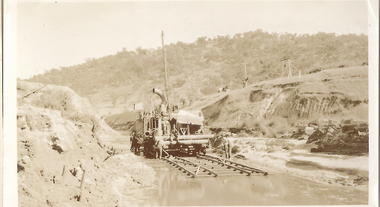
Cocks Pioneer Creek Diversion. Cocks Pioneer Electric Gold & Tin Mine Company was formed in 1899. The company's first power station, located at the eastern end of the valley began operating with its 340 Kilowatt steam-powered generator. By 1909, from 2,500,000 cubic yards worked, reported recovery was 17,284 ounces of gold and 224 tons of tin ore. By 1909, Cocks Pioneer’s power plant had become inadequate and uneconomical. The barge was floated downstream about a mile, but lost time caused the operations to cease. Following testing, a new mine was established by diverting Reid's Creek at a cost of £25,000. Settling dams were built, one of which held 1,935,900 cubic feet. Sold earth banks, built against a wall of stringy bark saplings constructed and laced with vertical props, were built. In 1914, the company was reformed as Cock’s Pioneer Gold and Tin Mines NL, another power station was constructed at the western end of the township, near the junction of Clear and Reid's Creeks. From 6,800,000 cubic yards of material processed, the returns were 64,397 ounces of gold and 855 ton of tin. Cocks Pioneer mine then moved the barge downs stream and continued sluicing. In 1929 Cocks Pioneer Electric Gold and Tin Mining Company ceased operations due to a drop in values. Cock’s Pioneer Gold and Tin Mines NL carried on large-scale hydraulic sluicing operations until 1941. mining, gold, tin, cocks pioneer, creek, gold mining, tin mining, el dorado, eldorado