Showing 8 items matching "snowy river (nsw)"
-
 Narre Warren and District Family History Group
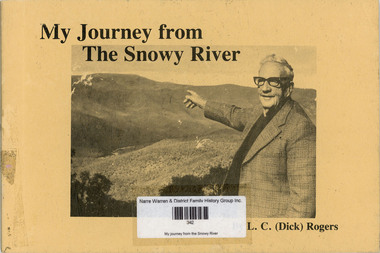
Book, LC 'Dick' Rogers, My journey from the Snowy River, 1982
... ...Snowy River (Vic.)...Snowy River (NSW...Narre Warren and District Family History Group 110 High Street Berwick melbourne droving Snowy River (Vic.) Snowy River (NSW) The reminiscences of LC Rogers outlining his life as a drover in Victoria and Queensland. ...The reminiscences of LC Rogers outlining his life as a drover in Victoria and Queensland. The author also describes the management of droving teams. Contents: Early days, Black Mountain Station, The bullock team, Dingoes, Shoeing horses, Bush days, Queensland experiences, Wulgulmerang, Later days at Wulgulmerang, Norwood - Swan Reach, Norwood - Kew, Travelling, The glorious future. Includes illustrations, maps and photographs.non-fictionThe reminiscences of LC Rogers outlining his life as a drover in Victoria and Queensland. The author also describes the management of droving teams. Contents: Early days, Black Mountain Station, The bullock team, Dingoes, Shoeing horses, Bush days, Queensland experiences, Wulgulmerang, Later days at Wulgulmerang, Norwood - Swan Reach, Norwood - Kew, Travelling, The glorious future. Includes illustrations, maps and photographs. droving, snowy river (vic.), snowy river (nsw) -
 Bendigo Military Museum
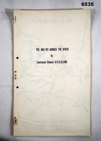
Journal - Royal Australian Survey Corps - The Bad Bit Across the River - LtCol HPG Clews 1934, LTCol HPG Clews RASvy, 1934
... River approximately 60 miles NW of Sydney, NSW. LtCol Clews was a remarkable man and his achievements were just as remarkable. He is affectionately known as "The Major." He served in the British Army 1909 - 1911 with the Sherwood Foresters. He then served in the Royal Australian Survey Corps from 1912 - 1949 and then served as the Senior Surveyor with the Snowy...River approximately 60 miles NW of Sydney, NSW. LtCol Clews was a remarkable man and his achievements were just as remarkable. He is affectionately known as "The Major." He served in the British Army 1909 - 1911 with the Sherwood Foresters. He then served in the Royal Australian Survey Corps from 1912 - 1949 and then served as the Senior Surveyor with the Snowy ...This Journal "The bad bit across the River" was written by - LtCol HPG Clews in 1934 and is about his experiences around the Colo River approximately 60 miles NW of Sydney, NSW. LtCol Clews was a remarkable man and his achievements were just as remarkable. He is affectionately known as "The Major." He served in the British Army 1909 - 1911 with the Sherwood Foresters. He then served in the Royal Australian Survey Corps from 1912 - 1949 and then served as the Senior Surveyor with the Snowy Mountains Authority from 1950-1958. A Survey Cairn is errected in Khancoban to record his life 1890 - 1980. This Journal records the field trip to establish Survey Control in very rugged country by a handful of party members on foot. The map shows the routes taken.14 x foolscap pages stapled and two hole punched. The Journal includes a map, 7 x pages of typed text and 4 x Annexesroyal australian survey corps, rasvy, fortuna, army survey regiment, army svy regt, asr, 2nd field survey company -
 Orbost & District Historical Society
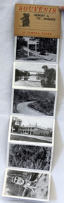
post cards, ca. 1945
... Snowy River bridge at Orbost, Snowy River at Orbost, Marlo from the sand dunes, Prince's Highway at Victorian-NSW. border, Genoa River and bridge at Genoa, Prince's Highway at Mt. ...River SOUVENIR Orbost to Vic Border 13 camera views A set of 13 black and white postcards in a fold-out format. Pictures are of : Nicholson Street, Snowy Rriver flats from Grand View, avenue leading to Obost. Snowy River bridge at Orbost, Snowy River at Orbost, Marlo from the sand dunes, Prince's Highway at Victorian-NSW ...This is a souvenir of Orbost from 1945.A set of 13 black and white postcards in a fold-out format. Pictures are of : Nicholson Street, Snowy Rriver flats from Grand View, avenue leading to Obost. Snowy River bridge at Orbost, Snowy River at Orbost, Marlo from the sand dunes, Prince's Highway at Victorian-NSW. border, Genoa River and bridge at Genoa, Prince's Highway at Mt. Drummer, Cann River hotel, fern scene, Euchre Valley, ponsasinorum near Cann River. SOUVENIR Orbost to Vic Border 13 camera viewspostcard souvenir photographs orbost cann-river -
 Orbost & District Historical Society
book, Snowy Water Inquiry, Snowy Water Inquiry Final Report, 1998
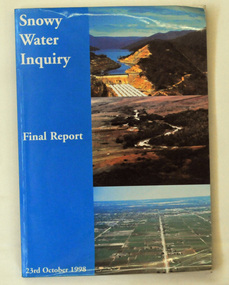
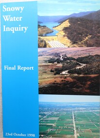
... The Snowy Water Inquiry was commissioned in 1998 with a brief to recommend environmental water release options to the Commonwealth, Victorian, and NSW Governments so that corporatisation of the Snowy Mountains Scheme could proceed. These release options related to the Snowy River...Orbost & District Historical Society Ruskin Street Orbost gippsland The Snowy Water Inquiry was commissioned in 1998 with a brief to recommend environmental water release options to the Commonwealth, Victorian, and NSW Governments so that corporatisation of the Snowy Mountains Scheme could proceed. These release options related to the Snowy River ...The Snowy Water Inquiry was commissioned in 1998 with a brief to recommend environmental water release options to the Commonwealth, Victorian, and NSW Governments so that corporatisation of the Snowy Mountains Scheme could proceed. These release options related to the Snowy River below Jindabyne, the Murray River and other rivers associated with the Scheme. The Inquiry objectives were that the recommendations would not adversely impact on water supplies to existing irrigators or the viability of the Snowy Mountains Scheme. (ref snowyhydro.com.au)This report contains information about water allocation and uses of the Snowy River.A book of 160 pp - Snowy River Inquiry Final report 23rd October 1998. Submitted to the Governments of New South Wales and Victoria / Commissioner: The Hon. Robert Webster. On the front cover are three aerial photographs of the Snowy River and Snowy Hydro Scheme. The book contains maps and photographs. snowy-river snowy-hydro snowy-mountains government-inquiry -
 Orbost & District Historical Society
Album - Florence M Taylor album, Florence M Taylor, c. 1910-1920s
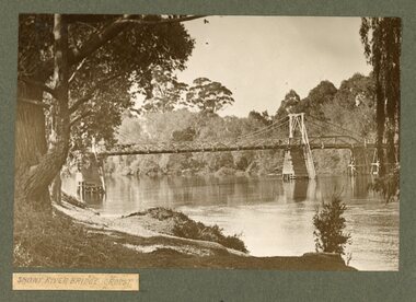
... NSW border. All photos were taken by J H Harvey in the early 20th century, and collected into this Album by Florence M Taylor who was Australia's first woman to be qualified as an architect and engineer. East Gippsland Orbost Genoa Cann River Bellbird Hotel Aboriginal camp Mallacoota Florence M Taylor Snowy ...This album was compiled by Florence M. Taylor who was the first women in Australia to be an architect, structural and civil engineer, town planner, and publisher. Florence was born in 1879 and died in 1969. Wikipedia: Florence Mary Taylor CBE (née Parsons; 29 December 1879 – 13 February 1969) was the first qualified female architect in Australia.[1] She was also the first woman in Australia to fly in a heavier-than-air craft in 1909[2] and the first female member of the UK's Institution of Structural Engineers in 1926.[3] However, she is best known for her role as publisher, editor and writer for the influential building industry trade journals established in 1907 with her husband George, which she ran and expanded after his death in 1928 until her retirement in 1961.[4] All photographs in this Album are attributed to J H Harvey (b1855, d1938), who was a well-known photographer, land surveyor and engineer. This album is significant because it contains photographs of East Gippsland, from Orbost to the NSW border. All photos were taken by J H Harvey in the early 20th century, and collected into this Album by Florence M Taylor who was Australia's first woman to be qualified as an architect and engineer. A grey covered album with gold lettering on the front and tied with cord along the spine. 8 pages with b/w photos. Some photos have been cut from the Album. All photos are labelled.on front cover: Through the county of Croagingolong, Victoria. Mrs F. M. Taylor.east gippsland, orbost, genoa, cann river, bellbird hotel, aboriginal camp, mallacoota, florence m taylor, snowy river bridge -
 Lakes Entrance Historical Society
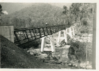
Photograph - Bridges, 1990
... Colour photograph showing McKillops Bridge across the Snowy River in the High Country near Deddick, East Gippsland near the Victorian / NSW border, south side of bridge, road to Deddick just visible opposite end, taken from west end of bridge. ...Lakes Entrance Historical Society 4 Marine Parade Lakes Entrance gippsland Also another photo taken later Bridges Waterways Topography Colour photograph showing McKillops Bridge across the Snowy River in the High Country near Deddick, East Gippsland near the Victorian / NSW border, south side of bridge, road to Deddick just visible opposite end, taken from west end of bridge. ...Also another photo taken laterColour photograph showing McKillops Bridge across the Snowy River in the High Country near Deddick, East Gippsland near the Victorian / NSW border, south side of bridge, road to Deddick just visible opposite end, taken from west end of bridge. River flowing to right, bridge of timber, steel and concrete, mountains around. East Gippsland Victoriabridges, waterways, topography -
 Wodonga & District Historical Society Inc
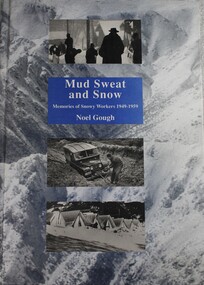
Book - Mud Sweat and Snow: Memories of Snowy Workers 1949-1959, Noel Gough, 1994
... Snowy Mountains Hydro-electric Scheme is a well-documented part of our nation’s history and a leading example of Australian innovation and ingenuity. As far back as the 1880s, Australians had been considering diverting water from some of Australia’s best-known rivers – the Murray, Murrumbidgee, Snowy and Tumut – to drought-proof parts of NSW and Victoria. ...This book tells the human story of the first decade of building the great Snowy Mountains Hydro-Electric Scheme, with adventures and anecdotes told by the workers themselves, and illustrated with unusual photographs. Appendices give further information about the project and list the workers named in Snowy records. The author began his 10 years with the Electrical and Mechanical Division at the age of 20. The construction of the Snowy Mountains Hydro-electric Scheme is a well-documented part of our nation’s history and a leading example of Australian innovation and ingenuity. As far back as the 1880s, Australians had been considering diverting water from some of Australia’s best-known rivers – the Murray, Murrumbidgee, Snowy and Tumut – to drought-proof parts of NSW and Victoria. It was not until 1944 that Commonwealth and State governments formed a committee to examine the development of water resources in the Snowy Mountains area. As a result of their work, on 7 July 1949, the Commonwealth Parliament passed legislation to establish a Statutory Authority and start construction of the Snowy Scheme. NSW. Construction was completed in 1974 at a total cost of $820 million. On completion, the Scheme consisted of seven power stations, 16 major dams, 80 kilometres of aqueducts and 145 kilometres of interconnected tunnels.non-fictionThis book tells the human story of the first decade of building the great Snowy Mountains Hydro-Electric Scheme, with adventures and anecdotes told by the workers themselves, and illustrated with unusual photographs. Appendices give further information about the project and list the workers named in Snowy records. The author began his 10 years with the Electrical and Mechanical Division at the age of 20. The construction of the Snowy Mountains Hydro-electric Scheme is a well-documented part of our nation’s history and a leading example of Australian innovation and ingenuity. As far back as the 1880s, Australians had been considering diverting water from some of Australia’s best-known rivers – the Murray, Murrumbidgee, Snowy and Tumut – to drought-proof parts of NSW and Victoria. It was not until 1944 that Commonwealth and State governments formed a committee to examine the development of water resources in the Snowy Mountains area. As a result of their work, on 7 July 1949, the Commonwealth Parliament passed legislation to establish a Statutory Authority and start construction of the Snowy Scheme. NSW. Construction was completed in 1974 at a total cost of $820 million. On completion, the Scheme consisted of seven power stations, 16 major dams, 80 kilometres of aqueducts and 145 kilometres of interconnected tunnels.snowy mountains hydro-electric scheme, hydroelectric power plants, snowy mountains -
 Wodonga & District Historical Society Inc
Book - Snowy Water Inquiry Final Report 23rd October 1998, Robert Webster et al, 1998
... Wodonga & District Historical Society Inc Hut 97, Bonegilla Migrant Experience, 132 Bonegilla Road Bonegilla the-murray snowy river hydro snowy river government inquiry water allocations water resources developmen The Snowy Water Inquiry was commissioned in 1998 with a brief to recommend environmental water release options to the Commonwealth, Victorian, and NSW Governments so that corporatisation of the Snowy Mountains Scheme could proceed. ...The Snowy Water Inquiry was commissioned in 1998 with a brief to recommend environmental water release options to the Commonwealth, Victorian, and NSW Governments so that corporatisation of the Snowy Mountains Scheme could proceed. This book contains the findings of the Inquiry into water allocation and uses of the Snowy River.A book of 160 pp - Snowy River Inquiry Final report 23rd October 1998. Submitted to the Governments of New South Wales and Victoria / Commissioner: The Hon. Robert Webster. On the front cover are three aerial photographs of the Snowy River and Snowy Hydro Scheme. The book contains maps and photographs.non-fictionThe Snowy Water Inquiry was commissioned in 1998 with a brief to recommend environmental water release options to the Commonwealth, Victorian, and NSW Governments so that corporatisation of the Snowy Mountains Scheme could proceed. This book contains the findings of the Inquiry into water allocation and uses of the Snowy River.snowy river hydro, snowy river government inquiry, water allocations, water resources developmen