Showing 8405 items matching "somer street"
-
 Sunshine and District Historical Society Incorporated
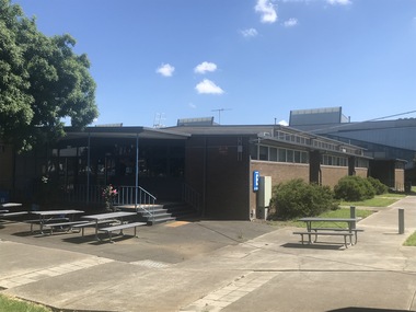
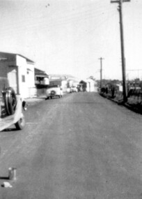
Photograph - Sunshine North Photographs 2021, John Alchin, 2021
... ...Somer Street...5621.01 - Ballarat Rd 438 - 460 Sunshine - Victoria University Sunshine Campus (Old Sunshine High School Library) 2021 Photo 01.JPG 5621.02 - Ballarat Rd 438 - 460 Sunshine - Victoria University Sunshine Campus 2021 Photo 03.JPG 5621.03 - Ballarat Rd 438 - 460 Sunshine - Victoria University Sunshine Campus 2021 Photo 02.JPG 5621.04 - Duke St Quarry West Side North of Surrey St 2021 Photo 01.JPG 5621.05 - Duke St Quarry West Side North of Surrey St 2021 Photo 08.JPG 5621.06 - Duke St Quarry West Side North of Surrey St 2021 Photo 05.JPG 5621.07 - Furlong Rd 18 - 44 North Sunshine Shops Photo 01.JPG 5621.08 - Furlong Rd 18 - 44 North Sunshine Shops Photo 02.JPG 5621.09 - Lloyd Reserve Sunshine North 2021 Photo 04.JPG 5621.10 - Lloyd Reserve Sunshine North 2021 Photo 05.JPG 5621.11 - Lloyd Reserve Sunshine North 2021 Photo 07.JPG 5621.12 - McIntyre Rd Road Bridge North Sunshine 2021 Photo 01.JPG 5621.13 - Pentecostal Missionary Church of Christ (4th Watch) 55 McIntyre Rd Sunshine North 2021 Photo 01.JPG 5621.14 - Phoenix St 120 Sunshine North 2021 Photo 03.JPG 5621.15 - Phoenix St Sunshine North - Faith & Power Ministry Revival Church North 2021 Photo 01.JPG 5621.16 - Railway Trestle Bridge North Sunshine 2021 Photo 04.JPG 5621.17 - Somers Street Sunshine North - Knights Stadium North 2021 Photo 02.JPG 5621.18 - St. ...Sunshine North Ballarat Road Duke Street Furlong Road McIntyre Road Phoenix Street Somer Street St. Albans Road Westmoreland Road Wiltshire Street Victoria University Sunshine High School Library Quarry Lloyd Reserve McIntyre Rd Road Bridge Pentecostal Missionary Church of Christ Faith & Power Ministry Revival Church North Railway Trestle Bridge Knights Stadium MMBW Depot Sunshine Christian School Maribyrnong Viaduct 5621.01 - Ballarat Rd 438 - 460 Sunshine - Victoria University Sunshine Campus (Old Sunshine High School Library) 2021 Photo 01.JPG 5621.02 - Ballarat Rd 438 - 460 Sunshine - Victoria University Sunshine Campus 2021 Photo 03.JPG 5621.03 - Ballarat Rd 438 - 460 Sunshine - Victoria University Sunshine Campus 2021 Photo 02.JPG 5621.04 - Duke St Quarry West Side North of Surrey St 2021 Photo 01.JPG 5621.05 - Duke St Quarry West Side North of Surrey St 2021 Photo 08.JPG 5621.06 - Duke St Quarry West Side North of Surrey St 2021 Photo 05.JPG 5621.07 - Furlong Rd 18 - 44 North Sunshine Shops Photo 01.JPG 5621.08 - Furlong Rd 18 - 44 North Sunshine Shops Photo 02.JPG 5621.09 - Lloyd Reserve Sunshine North 2021 Photo 04.JPG 5621.10 - Lloyd Reserve Sunshine North 2021 Photo 05.JPG 5621.11 - Lloyd Reserve Sunshine North 2021 Photo 07.JPG 5621.12 - McIntyre Rd Road Bridge North Sunshine 2021 Photo 01.JPG 5621.13 - Pentecostal Missionary Church of Christ (4th Watch) 55 McIntyre Rd Sunshine North 2021 Photo 01.JPG 5621.14 - Phoenix St 120 Sunshine North 2021 Photo 03.JPG 5621.15 - Phoenix St Sunshine North - Faith & Power Ministry Revival Church North 2021 Photo 01.JPG 5621.16 - Railway Trestle Bridge North Sunshine 2021 Photo 04.JPG 5621.17 - Somers Street Sunshine North - Knights Stadium North 2021 Photo 02.JPG 5621.18 - St. ...These photographs provide a visual record of assorted buildings, street views, and notable locations throughout Sunshine North in 2021.This collection of photographs preserves a visual record of Sunshine North 2021.5621.01 - Ballarat Rd 438 - 460 Sunshine - Victoria University Sunshine Campus (Old Sunshine High School Library) 2021 Photo 01.JPG 5621.02 - Ballarat Rd 438 - 460 Sunshine - Victoria University Sunshine Campus 2021 Photo 03.JPG 5621.03 - Ballarat Rd 438 - 460 Sunshine - Victoria University Sunshine Campus 2021 Photo 02.JPG 5621.04 - Duke St Quarry West Side North of Surrey St 2021 Photo 01.JPG 5621.05 - Duke St Quarry West Side North of Surrey St 2021 Photo 08.JPG 5621.06 - Duke St Quarry West Side North of Surrey St 2021 Photo 05.JPG 5621.07 - Furlong Rd 18 - 44 North Sunshine Shops Photo 01.JPG 5621.08 - Furlong Rd 18 - 44 North Sunshine Shops Photo 02.JPG 5621.09 - Lloyd Reserve Sunshine North 2021 Photo 04.JPG 5621.10 - Lloyd Reserve Sunshine North 2021 Photo 05.JPG 5621.11 - Lloyd Reserve Sunshine North 2021 Photo 07.JPG 5621.12 - McIntyre Rd Road Bridge North Sunshine 2021 Photo 01.JPG 5621.13 - Pentecostal Missionary Church of Christ (4th Watch) 55 McIntyre Rd Sunshine North 2021 Photo 01.JPG 5621.14 - Phoenix St 120 Sunshine North 2021 Photo 03.JPG 5621.15 - Phoenix St Sunshine North - Faith & Power Ministry Revival Church North 2021 Photo 01.JPG 5621.16 - Railway Trestle Bridge North Sunshine 2021 Photo 04.JPG 5621.17 - Somers Street Sunshine North - Knights Stadium North 2021 Photo 02.JPG 5621.18 - St. Albans Rd Sunshine North - Former MMBW Depot 2021 Photo 01.JPG 5621.19 - Westmoreland Rd 81 Sunshine North - Sunshine Christian School 2021 Photo 01.JPG 5621.20 - Westmoreland Rd 81 Sunshine North - Sunshine Christian School 2021 Photo 03.JPG 5621.21 - Wiltshire St 59 Sunshine North - 2021 Photo 01.JPG 5621.22 - Wiltshire St 59 Sunshine North - 2021 Photo 02.JPG 5621.23 - Maribyrnong Viaduct from Maribyrnong River Sth Side 2021 Video 01.MOV 5621.24 - Maribyrnong Viaduct from Maribyrnong River Sth Side 2021 Video 02.MOVsunshine north, ballarat road, duke street, furlong road, mcintyre road, phoenix street, somer street, st. albans road, westmoreland road, wiltshire street, victoria university, sunshine high school library, quarry, lloyd reserve, mcintyre rd road bridge, pentecostal missionary church of christ, faith & power ministry revival church north, railway trestle bridge, knights stadium, mmbw depot, sunshine christian school, maribyrnong viaduct -
 Greensborough Historical Society
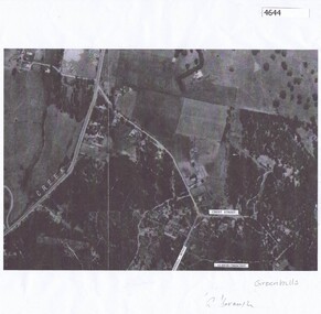
Map, Greenhills Estate 1945, 1945
... Black and white aerial map with some streets named...Aerial Map of Greenhills Estate 1945 greenhills aerial 1945 Black and white aerial map with some streets named Greenhills Estate 1945 Map Map ...Aerial Map of Greenhills Estate 1945 Black and white aerial map with some streets namedgreenhills, aerial 1945 -
 Greensborough Historical Society
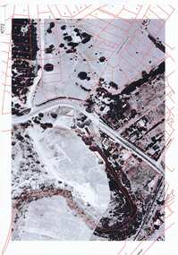
Aerial Photograph, Greenhills Aerial View, 1945_
... Photocopy of part of 1945 aerial survey. Some streets have been marked....Section from the 1945 aerial survey of Greensborough, including part of Diamond Creek Road, Greenhill Road, Crest Street and Albion Crescent. greenhills aerial 1945 Photocopy of part of 1945 aerial survey. Some streets have been marked. Greenhills Aerial View Aerial Photograph ...Section from the 1945 aerial survey of Greensborough, including part of Diamond Creek Road, Greenhill Road, Crest Street and Albion Crescent.Photocopy of part of 1945 aerial survey. Some streets have been marked.greenhills, aerial 1945 -
 Sunshine and District Historical Society Incorporated
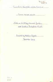
Document - Sunshine Harvester Works Timeline, Melcher Bajada
... Sunshine Harvester Works Timeline with some street names and notes on the H.V. McKay Memorial Gardens & Sunshine Presbyterian Church...A document complied by Melcher Bajada, S&DHS Reserch Officer Massey Ferguson Sunshine Harvester Works Sunshine Harvester Works Timeline with some street names and notes on the H.V. McKay Memorial Gardens & Sunshine Presbyterian Church An A4 typed document detailing key dates in the timeline of the Sunshine Harvester Works Document Sunshine Harvester Works Timeline Melcher Bajada ...A document complied by Melcher Bajada, S&DHS Reserch OfficerSunshine Harvester Works Timeline with some street names and notes on the H.V. McKay Memorial Gardens & Sunshine Presbyterian Churchmassey ferguson, sunshine harvester works -
Whitehorse Historical Society Inc.
Article, Readers all over the place, 2001
... Article on street sign construction by Art Craft, Nunawading, including photo of sign for Somers Street....Whitehorse Historical Society Inc. 2-10 Deep Creek Road Mitcham melbourne street signs art craft nunawading patterson matt naccari adrian holden lela Article on street sign construction by Art Craft, Nunawading, including photo of sign for Somers Street. Article on street sign construction by Art Craft, Nunawading, including photo of sign for Somers Street. ...Article on street sign construction by Art Craft, Nunawading, including photo of sign for Somers Street.Article on street sign construction by Art Craft, Nunawading, including photo of sign for Somers Street.Article on street sign construction by Art Craft, Nunawading, including photo of sign for Somers Street.street signs, art craft, nunawading, patterson, matt, naccari, adrian, holden, lela -
 Bendigo Historical Society Inc.
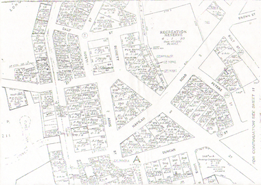
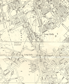
Map - LONG GULLY HISTORY GROUP COLLECTION: LONG GULLY
... Copy of a map of Long Gully area with some street names, size of allotments, number, measurements, date and names....History House 11 Mackenzie Street Bendigo goldfields BENDIGO History long gully history group The Long Gully History Group - Long Gully Housing Commission Housing Act 1958 Gazette Copy of a map of Long Gully area with some street names, size of allotments, number, measurements, date and names. ...Copy of a map of Long Gully area with some street names, size of allotments, number, measurements, date and names.bendigo, history, long gully history group, the long gully history group - long gully, housing commission, housing act 1958, gazette -
Whitehorse Historical Society Inc.
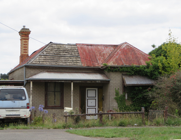
Newspaper - Article, 28 Somers Street, Mitcham, 31/08/1996
... Auction of 28 Somers Street, Mitcham on 7 September 1996. Alistair Knox, architect, owners, Joan and Noel Burley...Whitehorse Historical Society Inc. 2-10 Deep Creek Road Mitcham melbourne Somers Street Mitcham Knox Alistair Burley Joan Burley Noel Auctions Auction of 28 Somers Street, Mitcham on 7 September 1996. ...Auction of 28 Somers Street, Mitcham on 7 September 1996. Alistair Knox, architect, owners, Joan and Noel Burleysomers street, mitcham, knox, alistair, burley, joan, burley, noel, auctions -
 Bendigo Historical Society Inc.
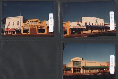
Photograph - National Trust Collection: 17 photographs of the frontage of properties fronting Mitchell Street, Bendigo, 1993
... Some Mitchell Street property address numbers on the rear of photographs...History House 11 Mackenzie Street Bendigo goldfields Social history, Historic buildings Millewa Hall Some Mitchell Street property address numbers on the rear of photographs National Trust Collection: 17 colour photographs of buildings with frontage to Mitchell Street, Bendigo - circa 1970s. ...Social history, Historic buildings National Trust Collection: 17 colour photographs of buildings with frontage to Mitchell Street, Bendigo - circa 1970s. Photos have hole punched in upper LH corner. 3229 a - Terminus Hotel 3229 b - cnr Mitchell & Wills Streets 3229 c - R. M. Hyett Motorcycles, cnr Mitchell and Mollison Streets 3229 d - Mitchell Street and Lyttleton Terrace and Mollison Street intersection 3229 e - Mitchell and Lyttleton Terrace intersection 3229 f - Mitchell and Lyttleton Terrace intersection 3229 g - 76-84 Mitchell Street 3229 h - 31-43 Mitchell Street 3229 i - "Toi Shan" Chinese restaurant 3229 j - Mitchell Street, Pall Mall to Hargreaves Street 3229 k - 79-85 Mitchell Street 3229 l - Bar-b-que Galore store, Mitchell Street 3229 m - 65-77 Mitchell Street 3229 n - ?? Mitchell Street 3229 o - 12-24 Mitchell Street; Plaza Theatre and Backhaus Building. Hargreaves Street to Bath Lane 3229 p - 58-74 Mitchell Street; Queen Street towards station 3229 q - Mitchell & Queen Street intersection, 26& 28 Mitchell StreetSome Mitchell Street property address numbers on the rear of photographsmillewa hall -
 Bendigo Historical Society Inc.
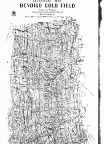
Map - LONG GULLY HISTORY GROUP COLLECTION: GEOLOGICAL MAP - BENDIGO GOLD FIELD
... Map shows Lines of Reef, Anticlines, Synclines, Shafts, Alluvial Contours Gullies and some street names. Copy is hard to read. There are two pages....Map shows Lines of Reef, Anticlines, Synclines, Shafts, Alluvial Contours Gullies and some street names. Copy is hard to read. There are two pages. ...Copy of a Geological Map of the Bendigo Gold Field. Map shows Lines of Reef, Anticlines, Synclines, Shafts, Alluvial Contours Gullies and some street names. Copy is hard to read. There are two pages.bendigo, history, long gully history group, the long gully history group - geological map - bendigo gold field, mines department, h herman, lightning hill line, hustlers line, derby line, paddy's gully line, garden gully line, deborah line, sheepshead line, new chum line, nell gwynne line, british and foreign line, napoleon line, carshalton line, thistle line, christmas line, lancashire line -
 Bendigo Historical Society Inc.
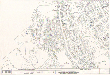
Map - LONG GULLY HISTORY GROUP COLLECTION: LONG GULLY AREA
... Made by the Land Titles Office. Some street names, reserves and allotment numbers are printed on the map....Made by the Land Titles Office. Some street names, reserves and allotment numbers are printed on the map. ...Copy of a map showing streets and allotments in the Long Gully area, last updated 30/05/97, printed 19/06/97. Made by the Land Titles Office. Some street names, reserves and allotment numbers are printed on the map.bendigo, history, long gully history group, the long gully history group - long gully area, land titles office, office of surveyor general, city of bendigo, shire of marong, state electricity commission -
Whitehorse Historical Society Inc.
Map, Subdivision Plan for part of Blackburn Park, c1910
... between the railway line and Whitehorse Road between Station Street and Alfred Street. Some purchasers noted between 1903 - 1912....Photocopy of advertisement for sale of subdivision of area in Blackburn between the railway line and Whitehorse Road between Station Street and Alfred Street. Some purchasers noted between 1903 - 1912....Whitehorse Historical Society Inc. 2-10 Deep Creek Road Mitcham melbourne between the railway line and Whitehorse Road between Station Street and Alfred Street. Some purchasers noted between 1903 - 1912. ...Photocopy of advertisement for sale of subdivision of area in BlackburnPhotocopy of advertisement for sale of subdivision of area in Blackburn between the railway line and Whitehorse Road between Station Street and Alfred Street. Some purchasers noted between 1903 - 1912.Photocopy of advertisement for sale of subdivision of area in Blackburnland subdivision, whitehorse road, blackburn, station street, blackburn, railway road, blackburn, queen street, blackburn, albert street, blackburn, chapel street, blackburn, george street, blackburn, cottage street, blackburn, alfred street, blackburn -
 Greensborough Historical Society
Map - Plan, Green's subdivision of Greensborough, 1860c
... This map shows the original subdivision of Greensborough by Edward Bernard Green. Some street names are different to today. ...This map shows the original subdivision of Greensborough by Edward Bernard Green. Some street names are different to today. This map shows the plan on which the town of Greensborough was based. edward bernard green greensborough Copy of early map showing subdivision of Greensborough. ...This map shows the original subdivision of Greensborough by Edward Bernard Green. Some street names are different to today. This map shows the plan on which the town of Greensborough was based.Copy of early map showing subdivision of Greensborough. Black ink on white paper.edward bernard green, greensborough -
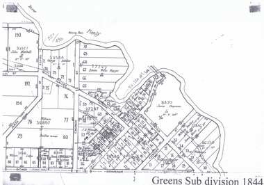 Greensborough Historical Society
Map - Plan, Green's subdivision of Greensborough 1844, 1844
... This map shows the original subdivision of Greensborough by Edward Bernard Green. Some street names are different to today. ...This map shows the original subdivision of Greensborough by Edward Bernard Green. Some street names are different to today. This map shows the plan on which the town of Greensborough was based. edward bernard green greensborough grimshaw street greensborough carter street flintoff street greensborough church street greensborough hailes street greensborough james st Copy of early map showing subdivision of Greensborough. ...This map shows the original subdivision of Greensborough by Edward Bernard Green. Some street names are different to today. This map shows the plan on which the town of Greensborough was based.Copy of early map showing subdivision of Greensborough. Black ink on white paper.edward bernard green, greensborough, grimshaw street greensborough, carter street, flintoff street greensborough, church street greensborough, hailes street greensborough, james st -
Greensborough Historical Society
Map - Plan, Green's subdivision of Greensborough1844 (part), 1844c
... This map shows the original subdivision of Greensborough by Edward Bernard Green. Some street names are different to today. ...This map shows the original subdivision of Greensborough by Edward Bernard Green. Some street names are different to today. This map shows the plan on which the town of Greensborough was based. edward bernard green greensborough Copy of early map showing subdivision of Greensborough. ...This map shows the original subdivision of Greensborough by Edward Bernard Green. Some street names are different to today. This map shows the plan on which the town of Greensborough was based.Copy of early map showing subdivision of Greensborough. Black ink on white paper.edward bernard green, greensborough -
Whitehorse Historical Society Inc.
Book, The Origins of Box Hill street names, 1985
... A listing of some of the streets of Box Hill with explanations as to their known or likely origins....A listing of some of the streets of Box Hill with explanations as to their known or likely origins. ...A listing of some of the streets of Box Hill with explanations as to their known or likely origins.A listing of some of the streets of Box Hill with explanations as to their known or likely origins.A listing of some of the streets of Box Hill with explanations as to their known or likely origins.box hill, street names -
 Greensborough Historical Society
Aerial Photograph, Greensborough aerial with property overlay, 1945_
... Enlargements of section of 1945 aerial survey photographs of central Greensborough, with property overlay boundaries and some street numbers by Noel Withers...Street names and some property numbers. Overlays by Noel Withers....Enlargements of section of 1945 aerial survey photographs of central Greensborough, with property overlay boundaries and some street numbers by Noel Withers greensborough plenty river aerial 1945 Street names and some property numbers. ...Enlargements of section of 1945 aerial survey photographs of central Greensborough, with property overlay boundaries and some street numbers by Noel WithersTwo photocopied enlargements with property overlay markingsStreet names and some property numbers. Overlays by Noel Withers.greensborough, plenty river, aerial 1945 -
 Stawell Historical Society Inc
Photograph, Railway Yards with loading ramps and weatherboard shed c1960
... Virtually the same view, but shows some more Wakeham Street houses. c 1960's. ...Showing Wakeham Street Houses in background c1960 stawell railways transport Virtually the same view, but shows some more Wakeham Street houses. c 1960's. ...Railway Yards Stawell with loading ramps and weatherboard shed. Showing Wakeham Street Houses in background c1960Virtually the same view, but shows some more Wakeham Street houses. c 1960's. stawell railways transport -
Melbourne Tram Museum
Document, Yarra Trams, "Ground Staff information for New Years Eve 2007", 21/12/2007
... Document titled "Ground Staff information for New Years Eve 2007", dated 21/12.2007, setting out the arrangements for the closure of some streets in the CBD for the New Year Celebrations. ...Melbourne Tram Museum 8 Wallen Road Hawthorn melbourne Document titled "Ground Staff information for New Years Eve 2007", dated 21/12.2007, setting out the arrangements for the closure of some streets in the CBD for the New Year Celebrations. ...Document titled "Ground Staff information for New Years Eve 2007", dated 21/12.2007, setting out the arrangements for the closure of some streets in the CBD for the New Year Celebrations. Has a table of contents. Gives background information, tram service changes, map, and ground staff names and staffing arrangement and site instructions for specific locations.Yields information about the tram arrangements in the CBD for the 2007/08 New Year Eve celebrations.Document - 16 A4 sheets stapled in top left hand corner.trams, tramways, new years eve, operations -
 Surrey Hills Historical Society Collection
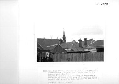
Photograph, View from Russell Street, of the rear 'Spencecroft' in 1988
... A black and white photograph of the rear of some buildings from Russell Street, at the rear of 'Spencecroft'....Some of the above may be in error. Research is currently being undertaken to authenticate claims previously asserted. house names spenceycroft spencecroft russell street surrey hills james rayment (mrs) elizabeth rayment A black and white photograph of the rear of some buildings from Russell Street, at the rear of 'Spencecroft'. ...Spenceycroft was home of James and Elizabeth Rayment, who had a dairy farm in the area in the 1870s. The house was located in Canterbury Road next to the Surrey Hills Presbyterian Church. For many years, it was hidden behind a large fence sheltering it from the noise of traffic along Canterbury Road. It has been claimed that it incorporated part of the original farmhouse built on the site by George Klepper, who planted a vineyard in the area. George’s family was one of a number of German families who settled in Surrey Hills during the later part of the 19th century. In recent years Spenceycroft was sold several times and became increasingly derelict. Since its last sale, it has been demolished. Some of the above may be in error. Research is currently being undertaken to authenticate claims previously asserted.A black and white photograph of the rear of some buildings from Russell Street, at the rear of 'Spencecroft'.house names, spenceycroft, spencecroft, russell street, surrey hills, james rayment, (mrs) elizabeth rayment -
 Sunshine and District Historical Society Incorporated
Administrative record - City of Sunshine - Commissioner Mr Alexander Alex George Gillon Collection 1976 - 1982 - Extraordinary Business Reports 4th April 1978, City of Sunshine, 4th April 1978
... Land Use Permit Car Sales Village Drive-In Theatre Somers Street Land Use Permit Storage of Fencing Materials Paramount Road Land Use Permit Bunting 556 Ballarat Road Land Use Permit Structure Improvements to existing service station Cnr Geelong Road and Francis Street Land Use Permit Alterations and additions to existing factory Lot 292 Hawthorn Avenue Land Use Permit Existing truck and earth moving equipment sales Geelong Road Land Use Permit Extensions of permit Flats Ballarat Road Variation Toilet Block Hampshire Road Plan of Subdivision Hook Street and Vule Street...City of Sunshine Alexander "Alex" George Gillon Somers Street Drive-In Theatre Sunshine North Paramount Road Tottenham Ballarat Road Albion Geelong Road Francis Street Brooklyn Hawthorn Avenue Ardeer Hampshire Road Sunshine Hook Street Vule Street St. ...Land Use Permit Car Sales Village Drive-In Theatre Somers Street Land Use Permit Storage of Fencing Materials Paramount Road Land Use Permit Bunting 556 Ballarat Road Land Use Permit Structure Improvements to existing service station Cnr Geelong Road and Francis Street Land Use Permit Alterations and additions to existing factory Lot 292 Hawthorn Avenue Land Use Permit Existing truck and earth moving equipment sales Geelong Road Land Use Permit Extensions of permit Flats Ballarat Road Variation Toilet Block Hampshire Road Plan of Subdivision Hook Street and Vule Street city of sunshine, alexander "alex" george gillon, somers street, drive-in theatre, sunshine north, paramount road, tottenham, ballarat road, albion, geelong road, francis street, brooklyn, hawthorn avenue, ardeer, hampshire road, sunshine, hook street, vule street, st. albans -
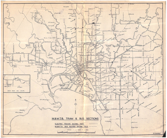 Melbourne Tram Museum
Map, Melbourne & Metropolitan Tramways Board (MMTB), "MMTB Tram and Bus Sections", mid 1960's?
... Shows railway lines, station, some cross streets. Scale 1"=1 Mile....Shows railway lines, station, some cross streets. Scale 1"=1 Mile. "MMTB Tram and Bus Sections" Map Melbourne & Metropolitan Tramways Board (MMTB) ...Map - photocopy - titled "MMTB Tram and Bus Sections" showing tram tracks and bus routes, drawing No. P13842, c mid 1960's, Footscray and Point Ormond shown as bus. Shows railway lines, station, some cross streets. Scale 1"=1 Mile.trams, tramways, map, buses, melbourne, footscray -
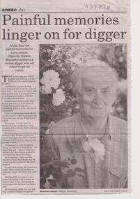 Whitehorse Historical Society Inc.
Article, Painful memories linger on, 19/04/2000
... Anzac Day feature on Raleigh Armstrong, returned World War 2 serviceman and on five Mitcham servicemen who died in the war, and after whom some Mitcham streets have been named, [note: errors in the article corrected] by Salena Brunsden. ...Also additional information provided by Giselda Bannister Anzac Day feature on Raleigh Armstrong, returned World War 2 serviceman and on five Mitcham servicemen who died in the war, and after whom some Mitcham streets have been named, [note: errors in the article corrected] by Salena Brunsden. ...Anzac Day feature on Raleigh Armstrong, returned World War 2 serviceman and on five Mitcham servicemen who died in the war, and after whom some Mitcham streets have been named, [note: errors in the article corrected] by Salena Brunsden. Also additional information provided by Giselda BannisterAnzac Day feature on Raleigh Armstrong, returned World War 2 serviceman and on five Mitcham servicemen who died in the war, and after whom some Mitcham streets have been named, [note: errors in the article corrected] by Salena Brunsden. Also additional information provided by Giselda Bannisternon-fictionAnzac Day feature on Raleigh Armstrong, returned World War 2 serviceman and on five Mitcham servicemen who died in the war, and after whom some Mitcham streets have been named, [note: errors in the article corrected] by Salena Brunsden. Also additional information provided by Giselda Bannisterarmstrong, raleigh edward, till, alwyn, loftus, owen spencer, bremner, william ross, peake, ronald mosely, vasey, george, young, joseph leopold, alwyn street, mitcham, owen street, mitcham, ross street, mitcham, ronald street, mitcham, vasey grove, mitcham, young street, mitcham, mcphee, peter -
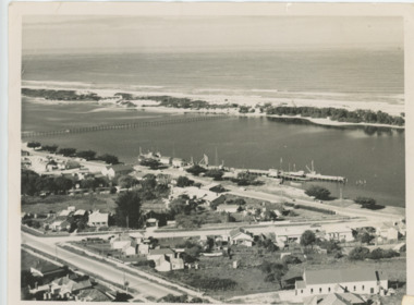 Lakes Entrance Historical Society
Photograph - Lakes Entrance, Brian Lloyd, c1954
... Black and white photograph of a section of the town taking in St Brendans church, Bulmer Street from Esplanade to Church Street, some of the waterfront, the footbridge and hummocks Lakes Entrance Victoria...Plus 2 other aerial views in album Aerial Photograph Township Beaches Black and white photograph of a section of the town taking in St Brendans church, Bulmer Street from Esplanade to Church Street, some of the waterfront, the footbridge and hummocks Lakes Entrance Victoria Photograph Lakes Entrance Brian Lloyd ...Aerial view of Lakes Entrance c1954. Plus 2 other aerial views in albumBlack and white photograph of a section of the town taking in St Brendans church, Bulmer Street from Esplanade to Church Street, some of the waterfront, the footbridge and hummocks Lakes Entrance Victoriaaerial photograph, township, beaches -
 Surrey Hills Historical Society Collection
Photograph, Stirling Crescent, Surrey Hills in 1930s, 1930s
... A black and white photograph of a street with some houses and cars on the left and electricity poles and the railway line on the right hand side....Phillip and Winifred Slavin are still listed in electoral roll in 1963 but by 1968 had moved to Gipps Street Collingwood, where he was still employed as a pastrycook. stirling crescent surrey hills bakery streetscape (Ms) Ada McBeath churches organist (Mr) Phillip Slavin (Mrs) Winifred Slavin streetscape pastrycook Wyclif Congregational Church (Mr) Paddy Slavin St Stephens Presbyterian Church A black and white photograph of a street with some houses and cars on the left and electricity poles and the railway line on the right hand side. ...Paddy Slavin had a bakery at 118 Union Road, which had a rear exit onto Stirling Crescent. On the left is part of Paddy Slavin’s Bakery at 118 Union Road. The house with the hedge was that of Ada McBeath, organist for many years at the St Stephens Presbyterian and the Wyclif Churches, who lived at No.16 from 1900-1943. Phillip and Winifred Slavin are still listed in electoral roll in 1963 but by 1968 had moved to Gipps Street Collingwood, where he was still employed as a pastrycook. A black and white photograph of a street with some houses and cars on the left and electricity poles and the railway line on the right hand side.stirling crescent, surrey hills, bakery, streetscape, (ms) ada mcbeath, churches, organist, (mr) phillip slavin, (mrs) winifred slavin, streetscape, pastrycook, wyclif congregational church, (mr) paddy slavin, st stephens presbyterian church -
 Victorian Interpretive Projects Inc.
Photograph - colour, Clare Gervasoni, House with shingle roof in Lydiard (North) Street, Ballarat, 2014, 18/01/2015
... Colour photograph of a clad weatherboard house in Lydiard (North) Street Ballarat. Some of the iron roofing has been removed exposing shingles....PO Box 93R, Redan, 3350 goldfields Although this house has been clad and had an iron roof put onto it, the historical integrity still appears to be intact. weatherboard shingles lydiard street house Colour photograph of a clad weatherboard house in Lydiard (North) Street Ballarat. Some of the iron roofing has been removed exposing shingles. ...Although this house has been clad and had an iron roof put onto it, the historical integrity still appears to be intact. Colour photograph of a clad weatherboard house in Lydiard (North) Street Ballarat. Some of the iron roofing has been removed exposing shingles.weatherboard, shingles, lydiard street, house -
 Bendigo Historical Society Inc.
Document - ENQUIRY: SAMUEL ROBBINS
... Enquiry re Samuel Robbins (died ca. 1885 - McIvor Street /Road?) Some information re possible reply?? ...Enquiry re Samuel Robbins (died ca. 1885 - McIvor Street /Road?) Some information re possible reply?? ...Enquiry re Samuel Robbins (died ca. 1885 - McIvor Street /Road?) Some information re possible reply?? On this page handwritten.person, individual, samuel robbins, jane penanula, brick layer. -
 Bendigo Historical Society Inc.
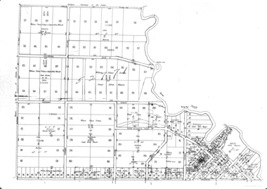
Map - LONG GULLY HISTORY GROUP COLLECTION: MAP OF LONG GULLY AREA
... Map shows Eaglehawk Road from Don Street to Weatherall Street, then Mt Korong Road to Dowding Street. Some contour lines on the map....Map shows Eaglehawk Road from Don Street to Weatherall Street, then Mt Korong Road to Dowding Street. Some contour lines on the map. Map LONG GULLY HISTORY GROUP COLLECTION: MAP OF LONG GULLY AREA ...BHS CollectionMap of Long Gully area printed on yellow paper. Map shows Eaglehawk Road from Don Street to Weatherall Street, then Mt Korong Road to Dowding Street. Some contour lines on the map.bendigo, history, long gully history group, the long gully history group - map of long gully area, borough of eaglehawk -
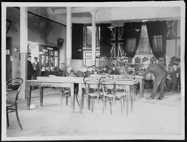 Mission to Seafarers Victoria
Photograph - Photograph, Sepia, c. 1910
... Men resting in the main hall of the Missions to seamen institute, Siddeley Street. Some are reading, the man standing is playing bagatelle, a form of pool game. ...Mission to Seafarers Victoria 717 Flinders Street Docklands melbourne seaman siddeley street institute main hall letters bentwood chairs post office bagatelle pool billiard games sailors In pencil: 137 Men resting in the main hall of the Missions to seamen institute, Siddeley Street. Some are reading, the man standing is playing bagatelle, a form of pool game. ...Men resting in the main hall of the Missions to seamen institute, Siddeley Street. Some are reading, the man standing is playing bagatelle, a form of pool game. On the left side at the back is the boot with sign saying: Sailors' lettersIn pencil: 137seaman, siddeley street institute, main hall, letters, bentwood chairs, post office, bagatelle, pool, billiard, games, sailors -
 Port Melbourne Historical & Preservation Society
Photograph - Harper's factory buildings, Beach and Rouse Streets, Port Melbourne. Awaiting redevelopment, 1980s
... c 1980s External view on Beach street of some of the buildings awaiting redevelopment. ...Port Melbourne Historical & Preservation Society Port Melbourne Town Hall 333 Bay Street Port Melbourne melbourne built environment built environment - commercial Harper's redevelopment Harper factory buildings on Beach and Rouse Streets (colour photo). c 1980s External view on Beach street of some of the buildings awaiting redevelopment. ...Harper factory buildings on Beach and Rouse Streets (colour photo). c 1980s External view on Beach street of some of the buildings awaiting redevelopment. built environment, built environment - commercial, harper's, redevelopment -
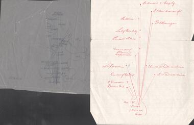 Bendigo Historical Society Inc.
Map - SNOB'S HILL - PLAN OF SNOB'S HILL AREA
... Plan drawn on tracing film of sand heap, dams, trig point and mines. Some un-named streets are also drawn in. Piece of notepaper has mines drawn in on a larger scale. ...History House 11 Mackenzie Street Bendigo goldfields MAP Bendigo goldfields Snob's Hill Plan of Snob's Hill Area New St Mungo Mullock Heap Duchess Trib S Devonshire Duchess of Edinburough W U Devonshire Hopewell Phoenix Unicorn Princess Alice Lady Barkly Sadowa E U Devonshire United Devonshire L? Ellenborough Belmont & Saxby Snob's Hill Plan drawn on tracing film of sand heap, dams, trig point and mines. Some ...Plan drawn on tracing film of sand heap, dams, trig point and mines. Some un-named streets are also drawn in. Piece of notepaper has mines drawn in on a larger scale. Notes prepared by Albert Richardson.map, bendigo, goldfields, snob's hill, plan of snob's hill area, new st mungo mullock heap, duchess trib, s devonshire, duchess of edinburough, w u devonshire, hopewell, phoenix, unicorn, princess alice, lady barkly, sadowa, e u devonshire, united devonshire, l?, ellenborough, belmont & saxby, snob's hill