Showing 182 items matching "south morang"
-
 NMIT (Northern Melbourne Institute of TAFE)
Photographs: Four framed of South Morang Rail Extension Project 2011-2012
... Photographs: Four framed of South Morang Rail Extension Project 2011-2012...Photographs: Four framed of South Morang Rail Extension Project 2011-2012...South Morang Rail Extension...Labelled ‘On behalf of the South Morang Rail Extension project we would like to thank you for your co-operation during construction.’ ...Probably 2011-2012 Photographs: Four framed of South Morang Rail Extension Project 2011-2012 Photographs: Four framed of South Morang Rail Extension Project 2011-2012 ...Four coloured photographs framed together of the NMIT Epping campus and Epping railway works. Labelled ‘On behalf of the South Morang Rail Extension project we would like to thank you for your co-operation during construction.’ Probably 2011-2012 south morang rail extension, epping campus, nmit -
 Greensborough Historical Society
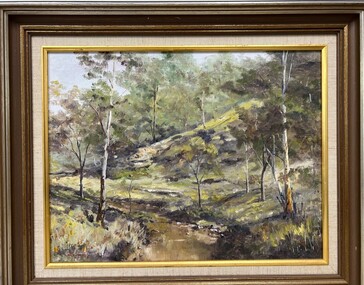
Painting - Painting (Framed), Plenty River South Morang by Doug Hall, 1970s
... Plenty River South Morang by Doug Hall......south morang...Bush scene of the Plenty River at South Morang showing young gum trees on the river bank, painted by Greensborough artist, the late Doug Hall....On back of painting "Plenty River South Morang. Doug Hall"...This painting has strong ties to the Greensborough area, being owned by Ivy Lines who gifted it to the donor's mother-in-law. doug hall plenty river south morang painters On back of painting "Plenty River South Morang. ...Bush scene of the Plenty River at South Morang showing young gum trees on the river bank, painted by Greensborough artist, the late Doug Hall.This painting has strong ties to the Greensborough area, being owned by Ivy Lines who gifted it to the donor's mother-in-law.Oil painting of a bush scene, in timber frame.On back of painting "Plenty River South Morang. Doug Hall"doug hall, plenty river, south morang, painters -
 Greensborough Historical Society
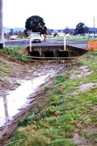
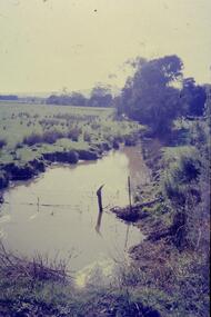
Slide - Photograph, John Ramsdale, Near Plenty Road South Morang: Slide 53, 1990s
... Near Plenty Road South Morang: Slide 53...plenty road south morang...Photograph shows drain and culvert near Plenty Road South Morang....Greensborough Historical Society 34A Glenauburn Road Lower Plenty Lower Plenty melbourne Photograph shows drain and culvert near Plenty Road South Morang. Part of the John Ramsdale collection of slides and audio visual material. plenty road south morang No maker's marks. ...Photograph shows drain and culvert near Plenty Road South Morang.Part of the John Ramsdale collection of slides and audio visual material.Colour photograph scanned from slide.No maker's marks. No caption on slide.plenty road south morang -
 Greensborough Historical Society
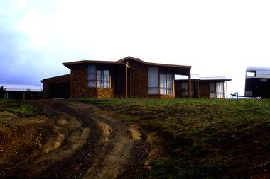
Slide - Photograph, John Ramsdale, Erosion, South Morang: Slide 113, 1990s
... Erosion, South Morang: Slide 113...gorge road south morang...Photograph shows a house with horse float and erosion on a poorly maintained driveway, Gorge Road South Morang. ...Greensborough Historical Society 34A Glenauburn Road Lower Plenty Lower Plenty melbourne Photograph shows a house with horse float and erosion on a poorly maintained driveway, Gorge Road South Morang. Part of the John Ramsdale collection of slides and audio visual material. gorge road south morang erosion No maker's marks. ...Photograph shows a house with horse float and erosion on a poorly maintained driveway, Gorge Road South Morang. Part of the John Ramsdale collection of slides and audio visual material.Colour photograph scanned from slide.No maker's marks. No caption on slide.gorge road south morang, erosion -
 Eltham District Historical Society Inc
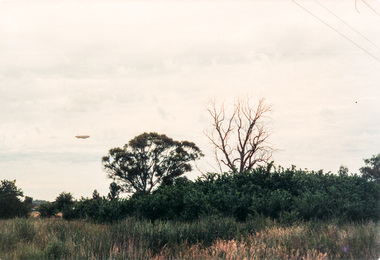
Photograph, Bond's Airship at South Morang
... Bond's Airship at South Morang......South Morang...Eltham District Historical Society Inc 728 Main Rd Eltham melbourne Originally contained in a 'magnetic' photo album believed to have been donated by Mr Eric Stephenson, Jingalong, 110 Ryans Road, Eltham, Vic. 3095; relocated to archival safe storage. airship South Morang Colour photograph Bond's Airship at South Morang Photograph ...Originally contained in a 'magnetic' photo album believed to have been donated by Mr Eric Stephenson, Jingalong, 110 Ryans Road, Eltham, Vic. 3095; relocated to archival safe storage.Colour photographairship, south morang -
 City of Whittlesea Art Collection
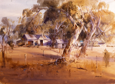
Painting - Watercolour on Saunders Medium Paper mounted on board, John Borrack, The Farm, South Morang, 1986
... The Farm, South Morang...south morang...City of Whittlesea Art Collection 25 Ferres Boulevard South Morang Part of the John and Gillian Borrack Federation Bequest, donated to the City of Whittlesea in December 2001 by Gillian and John Borrack south morang John Borrack 86 The Farm, Sth Morang The Farm, South Morang Painting Watercolour on Saunders Medium Paper mounted on board John Borrack ...This is a conventional watercolour. This fine old farm with its beautiful white barn was a landmark in South Morang until its demolition in the late 1970's. It was one of the first subjects in the area that I painted in the early 1950's. I later learnt from Alan Sumner, friend, painter and onetime head of the National Gallery School, that he constantly painted the same subject, as no doubt did other artists before him. I was quite upset about its demise, with the erection of a service station on the site. The two red gums are still there. In view of the quickening development of the area in which many historic landmarks, buildings and landscapes were disappearing, I painted the picture in my earlier more picturesque style purely to serve as a historical record of another lost legacy of the Plenty Valley. The early afternoon light and shadows through the red gums which frame the barn and outbuildings are all painted with a direct fluency on wet paper, to which the crisper touches were added after the initial stages were dry. The colour scheme evokes a typical summer's day and is uniquely Australian.Part of the John and Gillian Borrack Federation Bequest, donated to the City of Whittlesea in December 2001 by Gillian and John BorrackJohn Borrack 86 The Farm, Sth Morangsouth morang -
![Photograph - Digital image, John McLaughlin's home in Fairy Hill South Morang [distant view], 1910c](/media/collectors/4f729f5697f83e03086015b8/items/54bccb6e2162f10b905d311a/item-media/54bccb9e2162f10b905d3410/item-fit-380x285.jpg?cb=6) Greensborough Historical Society
Greensborough Historical SocietyPhotograph - Digital image, John McLaughlin's home in Fairy Hill South Morang [distant view], 1910c
... John McLaughlin's home in Fairy Hill South Morang [distant view]...This photograph shows John McLaughlin's home Fairy Hill in South Morang....John McLaughlin's home in Fairy Hill South Morang [distant view] Photograph - Digital image ...Part of a collection of photographs copied from the late Shirley Fraser (nee Black), also descendant of the McLaughlin and Whatmough family. This photograph shows John McLaughlin's home Fairy Hill in South Morang.Digital copy of black and white photograph.shirley fraser, john mclaughlin, fairy hill -
![Photograph - Digital image, John McLaughlin's home in Fairy Hill South Morang [close up], 1910c](/media/collectors/4f729f5697f83e03086015b8/items/54bccc242162f10b905d3efb/item-media/54bccc5b2162f10b905d420c/item-fit-380x285.jpg?cb=6) Greensborough Historical Society
Greensborough Historical SocietyPhotograph - Digital image, John McLaughlin's home in Fairy Hill South Morang [close up], 1910c
... John McLaughlin's home in Fairy Hill South Morang [close up]...This photograph shows John McLaughlin's home Fairy Hill in South Morang....John McLaughlin's home in Fairy Hill South Morang [close up] Photograph - Digital image ...Part of a collection of photographs copied from the late Shirley Fraser (nee Black), also descendant of the McLaughlin and Whatmough family. This photograph shows John McLaughlin's home Fairy Hill in South Morang.Digital copy of black and white photograph.shirley fraser, john mclaughlin, fairy hill -
 Greensborough Historical Society
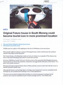
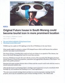
Article - Website, Paul Shapiro, Original Futuro house in South Morang, by Paul Shapiro, 02/07/2017
... Original Futuro house in South Morang, by Paul Shapiro...Of Finnish design, the building has been used as a sales booth at the Apollo Parkways estate, and moved to the TUKE Go-Kart Track on McDonalds Road South Morang, where it is being used as a storage building....Greensborough Historical Society 34A Glenauburn Road Lower Plenty Lower Plenty melbourne Of Finnish design, the building has been used as a sales booth at the Apollo Parkways estate, and moved to the TUKE Go-Kart Track on McDonalds Road South Morang, where it is being used as a storage building. futuro house apollo parkways 3 p. text and col. and black and white photographs (digital reprint of original publication) Original Futuro house in South Morang, by Paul Shapiro Article - Website Paul Shapiro Whittlesea Leader ...Of Finnish design, the building has been used as a sales booth at the Apollo Parkways estate, and moved to the TUKE Go-Kart Track on McDonalds Road South Morang, where it is being used as a storage building.3 p. text and col. and black and white photographs (digital reprint of original publication)futuro house, apollo parkways -
 Eltham District Historical Society Inc
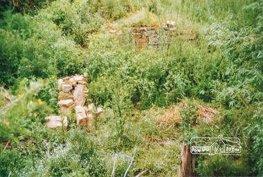
Photograph, Ruins of Coulstocks Mill, Janefield, South Morang
... Ruins of Coulstocks Mill, Janefield, South Morang...Tree near old mill site Ruins of Coulstocks Mill, Janefield, South Morang Photograph Photograph ...Mill Park Farm at Janefield on the Plenty River was established around 1840 by George Coulstock where he grew wheat. His flour mill was one of the first in Victoria, under construction as early as 1841. After bushfires and Coulstock's early death in 1842, the farm and its mill were taken over by local landowners Henry Miller and John Brock. Peter Hurlestone took charge of the mill. With water diverted from the Plenty River to fill the newly built Yan Yean Reservoir which opened in 1857, the Hurlestone family quit and that was the demise of the mill.Four colour photographs showing the ruins of Coulstocks Flour Mill (Janefield Mill), Janefield. 1. Stone wall 2. Old mill 3. Stone remains of old mill 4. Tree near old mill sitemills, flour mills, coulstock, janefield, plenty river, ruins, stone walls, plenty gorge, bundoora -
 Eltham District Historical Society Inc
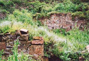
Photograph, Ruins of Coulstocks Mill, Janefield, South Morang
... Ruins of Coulstocks Mill, Janefield, South Morang...With water diverted from the Plenty River to fill the newly built Yan Yean Reservoir which opened in 1857, the Hurlestone family quit and that was the demise of the mill. mills flour mills coulstock janefield plenty river ruins stone walls bundoora plenty gorge Five colour photographs of ruins of Coulstocks Mill, Janefield (Mill Park - Bundoora) Ruins of Coulstocks Mill, Janefield, South Morang Photograph Photograph ...Mill Park Farm at Janefield on the Plenty River was established around 1840 by George Coulstock where he grew wheat. His flour mill was one of the first in Victoria, under construction as early as 1841. After bushfires and Coulstock's early death in 1842, the farm and its mill were taken over by local landowners Henry Miller and John Brock. Peter Hurlestone took charge of the mill. With water diverted from the Plenty River to fill the newly built Yan Yean Reservoir which opened in 1857, the Hurlestone family quit and that was the demise of the mill.Five colour photographs of ruins of Coulstocks Mill, Janefield (Mill Park - Bundoora)mills, flour mills, coulstock, janefield, plenty river, ruins, stone walls, bundoora, plenty gorge -
 Greensborough Historical Society
Slide - Photograph, John Ramsdale, Plenty River: Slide 19, 1990s
... south morang...Photograph shows low water flow on the Plenty River near South Morang or Mernda....Greensborough Historical Society 34A Glenauburn Road Lower Plenty Lower Plenty melbourne Photograph shows low water flow on the Plenty River near South Morang or Mernda. Part of the John Ramsdale collection of slides and audio visual material. south morang mernda plenty river No maker's marks. ...Photograph shows low water flow on the Plenty River near South Morang or Mernda.Part of the John Ramsdale collection of slides and audio visual material.Colour photograph scanned from slide.No maker's marks. No caption on slide.south morang, mernda, plenty river -
 City of Whittlesea
Badge - Badges - Advocacy Campaign, Access Denied, 2014
... ...south morang railway...The campaign called on all political parties to commit to extending the railway line from South Morang to Mernda and building access ramps on the Hume Freeway at O’Herns Road in Epping North. ...City of Whittlesea 25 Ferres Boulevard South Morang melbourne Access Denied was a joint advocacy campaign between the City of Whittlesea and the local community in the lead up to the 2014 Victorian State Election. ...Access Denied was a joint advocacy campaign between the City of Whittlesea and the local community in the lead up to the 2014 Victorian State Election. The campaign called on all political parties to commit to extending the railway line from South Morang to Mernda and building access ramps on the Hume Freeway at O’Herns Road in Epping North. The campaign was a success and secured almost $650 million in promises from the incoming Labor Government to build these projects. Badge, metal back with pin, white plastic printed front, black and red textConnect O'Herns Road / Access Denied / Get on Board / www.accessdenied.net.au / Build Mernda Railbadges, campaign badges, south morang railway, mernda railway -
Ballarat Tramway Museum
Sign - Sign - Destination Blinds, Trains, Vuictorian Rail Suburban Train Destination Blind in miniature - North and East stations, Melbourne
... ...south morang...Place names listed are Lalor, Epping, South Morang, Heidelberg, Macleod, Greensborough, Eltham, East Doncaster, Princes Bridge, City Circle, City Loop, Flinders Street, Spencer Street, Camberwell, Box Hill, Ringwood, Croydon, Lilydale, Coldstream, Upper Ferntree Gully, Belgrave, Alamein, Darling, Glen Waverley. ...Place names listed are Lalor, Epping, South Morang, Heidelberg, Macleod, Greensborough, Eltham, East Doncaster, Princes Bridge, City Circle, City Loop, Flinders Street, Spencer Street, Camberwell, Box Hill, Ringwood, Croydon, Lilydale, Coldstream, Upper Ferntree Gully, Belgrave, Alamein, Darling, Glen Waverley. train destination blind northern area eastern area lalor epping south morang macleod greensborough eltham hurstbridge east doncaster princes bridge city circle city loop flinders street spencer street camberwell box hill ringwood croydon lilydale coldstream upper ferntree gully belgrave alamein darling glen waverley Station names List of station names on black paper written in white Vuictorian Rail Suburban Train Destination Blind in miniature - North and East stations, Melbourne Sign Sign - Destination Blinds, Trains ...Ron Bridger was an avid collector of items related to transport, predominately Trams. These items include newspaper cuttings, pamphlets, reports, timetables, fares prices plus special items relating to events. Items from Melbourne and regional Victoria, interstate - Adelaide and Sydney, plus overseas, make up this collection. A suburban train destination blind in miniature. Place names indicate the northern and eastern suburbs that the train travels to. Place names listed are Lalor, Epping, South Morang, Heidelberg, Macleod, Greensborough, Eltham, East Doncaster, Princes Bridge, City Circle, City Loop, Flinders Street, Spencer Street, Camberwell, Box Hill, Ringwood, Croydon, Lilydale, Coldstream, Upper Ferntree Gully, Belgrave, Alamein, Darling, Glen Waverley. List of station names on black paper written in whiteStation namestrain destination blind, northern area, eastern area, lalor, epping, south morang, macleod, greensborough, eltham, hurstbridge, east doncaster, princes bridge, city circle, city loop, flinders street, spencer street, camberwell, box hill, ringwood, croydon, lilydale, coldstream, upper ferntree gully, belgrave, alamein, darling, glen waverley -
 Department of Energy, Environment and Climate Action
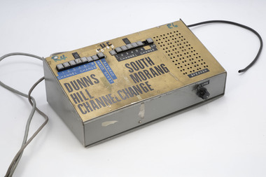
Radio Line Controller
... Dunns Hill and South Morang (fire towers)...Bushfire Radios Forests Commission Victoria (FCV) Dunns Hill and South Morang (fire towers) Radio line controller Radio Line Controller ...After the 1939 bushfires, the Forests Commission Victoria invested heavily in a radically new communications network. After suffering some inevitable delays due to the war, radio VL3AA switched into full operation in October 1945 proudly beaming out 200 watts across the State. But by today’s standards, the technology was primitive and the reception poor unless the user was on a high point somewhere. The radio signal was "line-of-sight" and bounced between fire towers and relay transmitters across the mountains back to the District offices. The advent of solid-state electronics in the 1960s replaced the more delicate valve sets which enabled greater use of vehicle mounted radios. The Commission continued to research, develop and build new radios at its many workshops around Victoria. The network was supported by a large team of skilled radio technicians. The more secure and versatile State Mobile Radio (SMR) digital trunk system came into operation in about 1995. Upgraded Tait Radios were purchased in 2014 after recommendations of the 2009 Bushfires Royal Commission. But it was the convergence of separate technologies such as 5G mobile phones, high-capacity and light-weight lithium batteries, Wi-Fi, the ever-expanding internet, cloud data storage, digital cameras, GPS, personal organisers and hundreds of supporting Apps into powerful smartphones and tablets which revolutionised bushfire communications from the mid-2000s. Radio line controllerDunns Hill and South Morang (fire towers)bushfire, radios, forests commission victoria (fcv) -
Whitehorse Historical Society Inc.
Map, Map of East and South eastern suburbs of Melbourne, 1930s
... Map of suburbs of Melbourne from Kew to Ringwood and South Morang Station to East Oakleigh....Whitehorse Historical Society Inc. 2-10 Deep Creek Road Mitcham melbourne Blackburn Mitcham Hawthorn Box Hill Doncaster Templestowe Map of suburbs of Melbourne from Kew to Ringwood and South Morang Station to East Oakleigh. Map of suburbs of Melbourne from Kew to Ringwood and South Morang Station to East Oakleigh. ...Map of suburbs of Melbourne from Kew to Ringwood and South Morang Station to East Oakleigh.Map of suburbs of Melbourne from Kew to Ringwood and South Morang Station to East Oakleigh.Map of suburbs of Melbourne from Kew to Ringwood and South Morang Station to East Oakleigh.blackburn, mitcham, hawthorn, box hill, doncaster, templestowe -
 St Patrick's Old Collegians Association (SPOCA)
Photograph - Students, 1920s
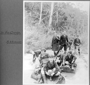
... c1928 Nine students in the Plenty River gorge at South Morang. Photographed by Fr John Forster SJ (Teacher 1925-32).. ...St Patrick's Old Collegians Association (SPOCA) Formerly Cnr of Cathedral Place & Lansdowne Street East Melbourne melbourne c1928 Nine students in the Plenty River gorge at South Morang. Photographed by Fr John Forster SJ (Teacher 1925-32).. ... -
 St Patrick's Old Collegians Association (SPOCA)
Photograph - Students, 1920s
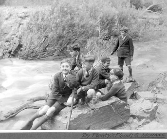
... c1928 Six students beside Plenty River flood at South Morang. Photographed by Fr John Forster SJ (Teacher 1925-32)....St Patrick's Old Collegians Association (SPOCA) Formerly Cnr of Cathedral Place & Lansdowne Street East Melbourne melbourne c1928 Six students beside Plenty River flood at South Morang. Photographed by Fr John Forster SJ (Teacher 1925-32). ... -
 Greensborough Historical Society
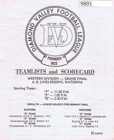
Pamphlet - Score sheet, Diamond Valley Football League, DVFL Teamlists and Scorecard. Western Division Grand Final F, E and D Grades, 1978c
... ...south morang football club...Western Division Grand Finals - F, E and D Grades diamond valley football league epping football club lalor football club south morang football club Greensborough colts dvfl 4 pages black text, black logo DVFL Teamlists and Scorecard. ...Teamlists and Scorecard for Diamond Valley Football League, c1978. Western Division Grand Finals - F, E and D Grades 4 pages black text, black logodiamond valley football league, epping football club, lalor football club, south morang football club, greensborough colts, dvfl -
 Greensborough Historical Society
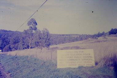
Slide - Photograph, John Ramsdale, Sign - Gorge Road: Slide 76, 1990s
... Photograph shows an anti- Plenty Gorge Park sign in Gorge Road South Morang...Greensborough Historical Society 34A Glenauburn Road Lower Plenty Lower Plenty melbourne Photograph shows an anti- Plenty Gorge Park sign in Gorge Road South Morang Part of the John Ramsdale collection of slides and audio visual material. plenty gorge plenty gorge metropolitan park melbourne and metropolitan board of works No maker's marks. ...Photograph shows an anti- Plenty Gorge Park sign in Gorge Road South MorangPart of the John Ramsdale collection of slides and audio visual material.Colour photograph scanned from slide.No maker's marks. No caption on slide.plenty gorge, plenty gorge metropolitan park, melbourne and metropolitan board of works -
 Greensborough Historical Society
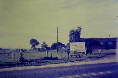
Slide - Photograph, John Ramsdale, Gorge Road sign: Slide 55, 1990s
... Photograph shows house with anti-Plenty Gorge Park sign, Gorge Road South Morang...Greensborough Historical Society 34A Glenauburn Road Lower Plenty Lower Plenty melbourne Photograph shows house with anti-Plenty Gorge Park sign, Gorge Road South Morang Part of the John Ramsdale collection of slides and audio visual material. plenty gorge plenty gorge metropolitan park melbourne and metropolitan board of works No maker's marks. ...Photograph shows house with anti-Plenty Gorge Park sign, Gorge Road South MorangPart of the John Ramsdale collection of slides and audio visual material.Colour photograph scanned from slide.No maker's marks. No caption on slide.plenty gorge, plenty gorge metropolitan park, melbourne and metropolitan board of works -
 Greensborough Historical Society
Newspaper Clipping - Digital Image, The Whittlesea Post, Futuro House Greensborough, 2017, 02/07/2017
... Written in 2017, this article reports on the history of the Futuro House, now in South Morang, but previously used in Greensborough as a temporary booth for sales of land at a new housing estate called Apollo Parkways....Greensborough Historical Society 34A Glenauburn Road Lower Plenty Lower Plenty melbourne Written in 2017, this article reports on the history of the Futuro House, now in South Morang, but previously used in Greensborough as a temporary booth for sales of land at a new housing estate called Apollo Parkways. futuro house apollo parkways Digital copy of newspaper clipping, black text and colour image. ...Written in 2017, this article reports on the history of the Futuro House, now in South Morang, but previously used in Greensborough as a temporary booth for sales of land at a new housing estate called Apollo Parkways.Digital copy of newspaper clipping, black text and colour image.futuro house, apollo parkways -
 Greensborough Historical Society
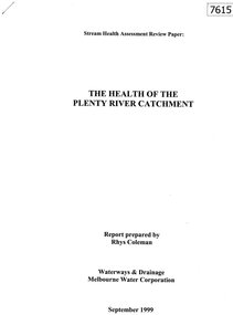
Document - Report, Rhys Coleman, The Health of the Plenty River Catchment 1999, 1999_09
... Report prepared by Rhys Coleman for Waterways and Drainage, Melbourne Water Corporation, discusses the health of the Plenty River catchment from upstream of Toorourrong Reservoir, through Whittlesea and Mernda, South Morang and Plenty to Greensborough and confluence with the Yarra River....Greensborough Historical Society 34A Glenauburn Road Lower Plenty Lower Plenty melbourne Report prepared by Rhys Coleman for Waterways and Drainage, Melbourne Water Corporation, discusses the health of the Plenty River catchment from upstream of Toorourrong Reservoir, through Whittlesea and Mernda, South Morang and Plenty to Greensborough and confluence with the Yarra River. plenty river melbourne water corporation 31 p., tables. ...Report prepared by Rhys Coleman for Waterways and Drainage, Melbourne Water Corporation, discusses the health of the Plenty River catchment from upstream of Toorourrong Reservoir, through Whittlesea and Mernda, South Morang and Plenty to Greensborough and confluence with the Yarra River.31 p., tables.plenty river, melbourne water corporation -
 Ithacan Historical Society
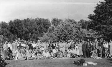
Photograph, Ithacan picnic, c1947
... The first picnic was held in 1918 at South Morang. The picnics were usually held at location on the outskirts of Melbourne and for many years Bacchus Marsh's Maddingley Park was a popular location for the picnic...The first picnic was held in 1918 at South Morang. The picnics were usually held at location on the outskirts of Melbourne and for many years Bacchus Marsh's Maddingley Park was a popular location for the picnic The annual picnic has been held annually since 1918, except for 1919 when it was postponed due to outbreak of the Spanish Influenza in Melbourne, and in 2021 due to the Covid pandemic. ...The group photo was taken at the annual Ithacan Philanthropic Society picnic at Bacchus Marsh. The first picnic was held in 1918 at South Morang. The picnics were usually held at location on the outskirts of Melbourne and for many years Bacchus Marsh's Maddingley Park was a popular location for the picnicThe annual picnic has been held annually since 1918, except for 1919 when it was postponed due to outbreak of the Spanish Influenza in Melbourne, and in 2021 due to the Covid pandemic. In the early years the annual picnic gave families a chance to spend time in the countryside and to socialize with other Ithacans. It remains a popular event on the society's social calendar where families of generations with Ithacan ancestry catch up.A black and white photograph with a thin white border of a large group of people standing and sitting together in a large open area. There are trees in the background. Stamped on the back in black: 45 49. -
 Ithacan Historical Society
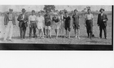
Photograph, Ithacan picnic races, c1930s
... The first picnic was held on 24 March 1918 at a picnic ground in South Morang. The races for all age groups are a popular feature of the day's entertainment. ...The first picnic was held on 24 March 1918 at a picnic ground in South Morang. The races for all age groups are a popular feature of the day's entertainment. ...The annual picnic has been an important social event for the Ithacan Philanthropic Society. The first picnic was held on 24 March 1918 at a picnic ground in South Morang. The races for all age groups are a popular feature of the day's entertainment. In this photograph seven young men are preparing to participate in the men's race.A black and white photograph with a white header and footer of twelve men in an open area. Seven of the men are lined up to begin a foot race while the other five looking on and deciding when to start the race. One of the open lookers is holding a camera. -
 Melbourne Tram Museum
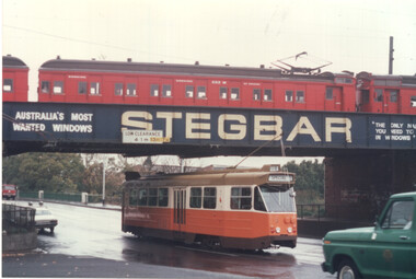
Photograph - Colour print - Z1 No. 3 passing under Clifton Hill rail bridge - Tait train, June 1975
... Colour print showing Z1 No 3 in Queens Parade passing under the Epping/South Morang railway line bridge at Clifton Hill. ...Melbourne Tram Museum 8 Wallen Road Hawthorn melbourne Colour print showing Z1 No 3 in Queens Parade passing under the Epping/South Morang railway line bridge at Clifton Hill. ...Colour print showing Z1 No 3 in Queens Parade passing under the Epping/South Morang railway line bridge at Clifton Hill. A Tait train is passing over the bridge. The tram is showing Special. Probably at the time of the launch of the Z class trams in June 1975. Ford F100 Service vehicle following. Yields information about an interface between rail and tram in Melbourne.Colour print on paper - Kodak Royal Papertrams, tramways, z class tram, z1 class, tram 3, clifton hill, queens parade, tait trains, railways, service vehicle, merri creek -
 Eltham District Historical Society Inc
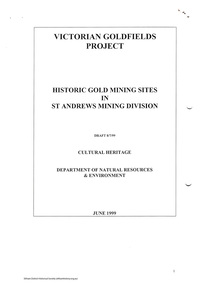
Folder, Victorian Goldfields Project: Historic gold mining sites in St Andrews mining division, 1999
... Includes information on the Warrandyte Goldfield and the Caledonia Goldfield, Queenstown (now known as St Andrews), One Tree Hill, Kingston (now known as Panton Hill), Kangaroo Grounds, You You Hill, Kingstown, South Morang, Nillumbik, (now known as Diamond Creek), Steele's Creek, Yarrambet and Kinglake. ...Includes information on the Warrandyte Goldfield and the Caledonia Goldfield, Queenstown (now known as St Andrews), One Tree Hill, Kingston (now known as Panton Hill), Kangaroo Grounds, You You Hill, Kingstown, South Morang, Nillumbik, (now known as Diamond Creek), Steele's Creek, Yarrambet and Kinglake. ...Heritage site report and gazetteer by David Bannear, head consultant for archealogy for the Department of Natural Resources and Environment. Includes information on the Warrandyte Goldfield and the Caledonia Goldfield, Queenstown (now known as St Andrews), One Tree Hill, Kingston (now known as Panton Hill), Kangaroo Grounds, You You Hill, Kingstown, South Morang, Nillumbik, (now known as Diamond Creek), Steele's Creek, Yarrambet and Kinglake. Photocopy of map headed: Location of mines and reefs from Geological survey of Victoria, Yan Yean with the Diamond Creek prominant on the map. no date35 page report with map and print out of cover letter (email form) from donorcaledonian gold fields, caledonina gold field, david bannear, gold mining, harry gilham collection, queenstown, st andrews, warrandyte goldfield -
 City of Whittlesea
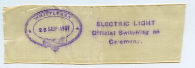
Memorabilia - Commemorative Ribbons, Electric Light Official Switching On Ceremony ribbon, 1937
... There were initially 78 customers, including the Shire of Whittlesea which had contracted the SEC to supply street lighting in Whittlesea, Yan Yean, Mernda and South Morang (Advertiser, Friday 1st October 1937, page 1). ...City of Whittlesea 25 Ferres Boulevard South Morang melbourne On Tuesday 28th September 1937, to the applause and cheering of a crowd of more than 300 people, a ceremonial ribbon was cut with a ‘beautiful pair of silver scissors’ by Mrs W H Everard, wife of local MP William Everard. ...On Tuesday 28th September 1937, to the applause and cheering of a crowd of more than 300 people, a ceremonial ribbon was cut with a ‘beautiful pair of silver scissors’ by Mrs W H Everard, wife of local MP William Everard. The ribbon cutting ceremony was to officially turn on the mains electricity supply to Whittlesea and district. The moment the ribbon was cut there was a ‘blaze of light’. There were initially 78 customers, including the Shire of Whittlesea which had contracted the SEC to supply street lighting in Whittlesea, Yan Yean, Mernda and South Morang (Advertiser, Friday 1st October 1937, page 1). This ribbon is possibly a fragment of the official opening ribbon that was stamped with the date and details of the switching on of electricity in Whittlesea and given to patrons. Commemorative Ribbons. Silk ribbon, white, stamped with details commemorating the switching on of electricity in Whittlesea on 28 September 1937.Whittlesea / 28 Sep 1937 / Electric Light / Official Switching on / Ceremony electricy supply, w h everard, whittlesea district -
 City of Whittlesea
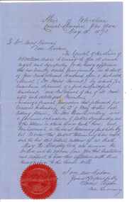
Document - Correspondence, Council letter to Mrs Moses Thomas 1868, 1878
... It covered part of what is today Mernda, Doreen, South Morang, Mill Park and Bundoora. In 1875, the area merged with the Whittlesea Road District to form the Shire of Whittlesea. ...City of Whittlesea 25 Ferres Boulevard South Morang melbourne In 1851 Moses Thomas purchased 400 acres, including a half mile frontage to the Plenty River, at Mernda (then known as Morang) where he operated a farm, inn and other business. ...In 1851 Moses Thomas purchased 400 acres, including a half mile frontage to the Plenty River, at Mernda (then known as Morang) where he operated a farm, inn and other business. In 1865 Moses Thomas was appointed Engineer, Clerk and Collector for the Morang District Road Board. In this role he would have been responsible for overseeing the collection of local property rates and the maintenance and construction of local roads and drains. Road District Boards were one of the earliest forms of local government in Victoria. The Morang or Upper Plenty Road District was established in 1862. It covered part of what is today Mernda, Doreen, South Morang, Mill Park and Bundoora. In 1875, the area merged with the Whittlesea Road District to form the Shire of Whittlesea. Moses Thomas briefly served as a Councillor with the Shire of Whittlesea until his death in 1878. Correspondence. Letter, paper, handwritten text with seal. Letter from James Ryan, Shire Secretary, Shire of Whittlesea to Mrs Moses Thomas on the death of Moses 18 May 1878. -
Eltham District Historical Society Inc
Document - Folder, Macmillan, Donald
... Morang Victoria...Arthurs Creek Victoria...Ann MacMillan...Hazel Glen School Victoria...South...They lived at Morang but, in 1866, selected land at Arthurs Creek. Hugh and his sister Ann attended the Hazel Glen School. Later Hugh carried mail from South Yan Year (now Mernda) to Arthurs Creek School (also the post office); he was Sunday School teacher at the Arthurs Creek Methodist Church. ...They lived at Morang but, in 1866, selected land at Arthurs Creek. Hugh and his sister Ann attended the Hazel Glen School. Later Hugh carried mail from South Yan Year (now Mernda) to Arthurs Creek School (also the post office); he was Sunday School teacher at the Arthurs Creek Methodist Church. ...Donald MacMillan (widower) with his six children eft Inverness, Scotland, in 1849, and worked as a shepherd on Plenty River property of Captain Aneas McPerson, under the manager Thomas Walker. MacMillan married again and son Hugh was born 1860, first of another six children. They lived at Morang but, in 1866, selected land at Arthurs Creek. Hugh and his sister Ann attended the Hazel Glen School. Later Hugh carried mail from South Yan Year (now Mernda) to Arthurs Creek School (also the post office); he was Sunday School teacher at the Arthurs Creek Methodist Church. Hugh married Helena Heatley from New Zealand who managed the farm after Hugh died, growing fruit and vegetables, carted by wagon to the Victoria Market. Their firstborn was Ken. Contents Newspaper article: "Donald MacMillan - a romantic", Diamond Valley News, 29 October 1985, pp30-31; history of MacMillan family. Newspaper article: "An alternative road to happiness", Diamond Valley News, 29 October 1985, p29; Mic Webb's travels and philosophy, now living at Hurstbridge.Newspaper clippings, A4 photocopies, etcdonald macmillan, plenty river victoria, captain aneas mcpherson, thomas walker, morang victoria, arthurs creek victoria, ann macmillan, hazel glen school victoria, south yan yean victoria, mernda victoria, arthurs creek school victoria, arthurs creek methodist church, malcolm macmillan, helena macmillan nee heatley, ken macmillan, mic webb, hurstbridge learning co-op, hurstbridge victoria, cottlesbridge victoria, st andrews victoria