Showing 97 items matching "spillways"
-
 Lakes Entrance Historical Society
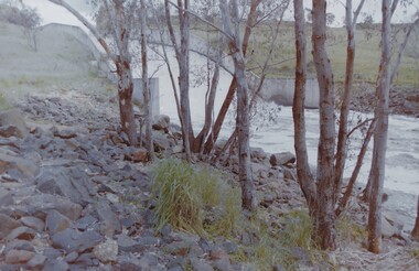
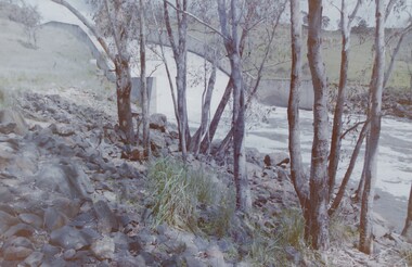
Photograph - Glenmaggie Weir Gippsland 1990
... also 2 other photos of the spillway 5220.1.and .2...Colour Photograph of spillway at Glenmaggie Weir Gipsland Victoria...also 2 other photos of the spillway 5220.1.and .2 Weirs Colour Photograph of spillway at Glenmaggie Weir Gipsland Victoria Photograph Glenmaggie Weir Gippsland 1990 ...also 2 other photos of the spillway 5220.1.and .2Colour Photograph of spillway at Glenmaggie Weir Gipsland Victoriaweirs -
 Buninyong & District Historical Society
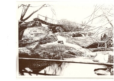
Photograph - Black and white photograph of Archibald Fisken on a bridge on Lal Lal Estate early 1900s, Archibald Fisken on "New Bridge" Lal Lal Estate early 1900s
... A black and white photograph showing a creek and Arthur Fisken standing on a wooden bridge to the rear over the spillway...Archibald Fisken on the New Bridge Early 1900s, an early bridge over the spillway Lal Lal Park...One of a series of photographs featuring the Fisken Family on the Lal Lal Estate The image shows a water system on an early Estate near Buninyong Fisken Family Lal Lal Estate Rural life Water ways Archibald Fisken on the New Bridge Early 1900s, an early bridge over the spillway Lal Lal Park A black and white photograph showing a creek and Arthur Fisken standing on a wooden bridge to the rear over the spillway Archibald Fisken on "New Bridge" Lal Lal Estate early 1900s Photograph Black and white photograph of Archibald Fisken on a bridge on Lal Lal Estate early 1900s ...One of a series of photographs featuring the Fisken Family on the Lal Lal EstateThe image shows a water system on an early Estate near BuninyongA black and white photograph showing a creek and Arthur Fisken standing on a wooden bridge to the rear over the spillwayArchibald Fisken on the New Bridge Early 1900s, an early bridge over the spillway Lal Lal Parkfisken family, lal lal estate, rural life, water ways -
 Kiewa Valley Historical Society
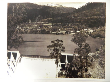
Photo - Early photo of Bogong Township x2
... This photo shows their homes and offices etc., Lake Guy and the spillway during construction days....Large photo of Mt Bogong Township with snow on the mountain in the background and the spillway over-flowing in the foreground. Some small trees amongst those burnt by the 1939 bushfire. (2 photos - one an enlarged copy)...This photo shows their homes and offices etc., Lake Guy and the spillway during construction days. Bogong village was built as part of the Kiewa Hydro Electric Scheme. ...Bogong Village was built for the workers of the State Elecricity Commission of Victoria who were employed to construct the Kiewa Hydro electric Scheme. This photo shows their homes and offices etc., Lake Guy and the spillway during construction days.Bogong village was built as part of the Kiewa Hydro Electric Scheme. This photo gives a view of the village when it was at its peak. Large photo of Mt Bogong Township with snow on the mountain in the background and the spillway over-flowing in the foreground. Some small trees amongst those burnt by the 1939 bushfire. (2 photos - one an enlarged copy)bogong village. kiewa hydro electric scheme. s.e.c.v.. lake guy. -
 Tatura Irrigation & Wartime Camps Museum
Photograph, Eildon Reservoir - Goulburn River, 1918
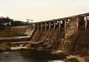
... Eildon Reservoir on the Goulburn River / Overall picture of dam (Right of wall) filled with water and some leisure craft moored near shore and huts / Dam wall and spillway / tree covered hills beyond..."Eildon Reservoir - Goulburn River / Capacity - 306,000 acre feet / Rock filled dam with mass concrete spillway / Total length of dam - 3000 feet / Maximum depth of water - 123 feet - etc"...Eildon Reservoir on the Goulburn River / Overall picture of dam (Right of wall) filled with water and some leisure craft moored near shore and huts / Dam wall and spillway / tree covered hills beyond Eildon Reservoir - Goulburn River Photograph ...Taken by photographer for State Rivers and Water Supply Commission.Medium sized black and white photograph. Eildon Reservoir on the Goulburn River / Overall picture of dam (Right of wall) filled with water and some leisure craft moored near shore and huts / Dam wall and spillway / tree covered hills beyond"Eildon Reservoir - Goulburn River / Capacity - 306,000 acre feet / Rock filled dam with mass concrete spillway / Total length of dam - 3000 feet / Maximum depth of water - 123 feet - etc"victorian state rivers and supply commission, eildon dam -
 Bendigo Historical Society Inc.
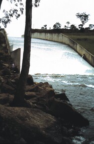
Slide - VAL DENSWORTH COLLECTION: EPPALOCK SPILLWAY, Oct 1988
... Slide. Eppalock Spillway. Water cascading over the spillway....History House 11 Mackenzie Street Bendigo goldfields SLIDE Bendigo eppalock spillway. Eppalock Spillway. Slide. Eppalock Spillway. ...Slide. Eppalock Spillway. Water cascading over the spillway.slide, bendigo, eppalock spillway., eppalock spillway. -
 Bendigo Historical Society Inc.
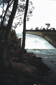
Slide - VAL DENSWORTH COLLECTION: EPPALOCK SPILLWAY, Oct 1988
... Slide. Eppalock Spillway. Water flowing over the spillway....History House 11 Mackenzie Street Bendigo goldfields SLIDE Bendigo eppalock spillway. Eppalock Spillway. Slide. Eppalock Spillway. ...Slide. Eppalock Spillway. Water flowing over the spillway.slide, bendigo, eppalock spillway., eppalock spillway. -
 Bendigo Historical Society Inc.
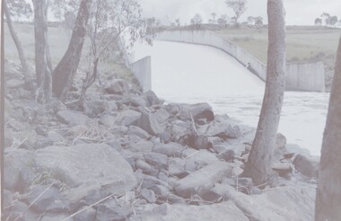
Slide - VAL DENSWORTH COLLECTION: EPPALOCK SPILLWAY, Oct 1988
... Slide. Eppalock Spillway. Water flowing over and down the spillway....History House 11 Mackenzie Street Bendigo goldfields SLIDE Bendigo eppalock spillway. Eppalock Spillway. Slide. Eppalock Spillway. ...Slide. Eppalock Spillway. Water flowing over and down the spillway.slide, bendigo, eppalock spillway., eppalock spillway. -
 Bendigo Historical Society Inc.
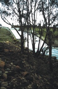
Slide - VAL DENSWORTH COLLECTION: LAKE EPPALOCK, 1986
... Negative. Lake Eppalock spillway, water running over spillway. Dated November1986...History House 11 Mackenzie Street Bendigo goldfields SLIDE Bendigo Lake Eppalock spillway water running over spillway Negative. ...Negative. Lake Eppalock spillway, water running over spillway. Dated November1986slide, bendigo, lake eppalock spillway, water running over spillway -
 Bendigo Historical Society Inc.
Slide - VAL DENSWORTH COLLECTION: LAKE EPPALOCK, 1986
... Negative. Lake Eppalock spillway, water running over spillway. Dated November1986...History House 11 Mackenzie Street Bendigo goldfields SLIDE Bendigo lake eppalock Lake Eppalock water over spillway Negative. Lake Eppalock spillway, water running over spillway. ...Negative. Lake Eppalock spillway, water running over spillway. Dated November1986slide, bendigo, lake eppalock, lake eppalock water over spillway -
 Bendigo Historical Society Inc.
Slide - VAL DENSWORTH COLLECTION: LAKE EPPALOCK, 1986
... Negative. Lake Eppalock spillway, water running over spillway. Dated November1986...History House 11 Mackenzie Street Bendigo goldfields SLIDE Bendigo lake eppalock Lake Eppalock spillway near Bendigo Negative. Lake Eppalock spillway, water running over spillway. ...Negative. Lake Eppalock spillway, water running over spillway. Dated November1986slide, bendigo, lake eppalock, lake eppalock spillway near bendigo -
 Bendigo Historical Society Inc.
Slide - VAL DENSWORTH COLLECTION: LAKE EPPALOCK, 1986
... Negative. Lake Eppalock spillway, water running over spillway. Dated November 1986...History House 11 Mackenzie Street Bendigo goldfields SLIDE Bendigo lake eppalock Lake Eppalock spillway overflow Negative. Lake Eppalock spillway, water running over spillway. ...Negative. Lake Eppalock spillway, water running over spillway. Dated November 1986slide, bendigo, lake eppalock, lake eppalock spillway overflow -
 Bendigo Historical Society Inc.
Slide - VAL DENSWORTH COLLECTION: LAKE EPPALOCK, 1986
... Negative. Lake Eppalock spillway, Campaspe River at the base of the spillway. ...History House 11 Mackenzie Street Bendigo goldfields SLIDE Bendigo lake eppalock Lake Eppalock spillway Campaspe River Negative. Lake Eppalock spillway, Campaspe River at the base of the spillway. ...Negative. Lake Eppalock spillway, Campaspe River at the base of the spillway. Dated November 1986slide, bendigo, lake eppalock, lake eppalock spillway campaspe river -
 Bendigo Historical Society Inc.
Slide - VAL DENSWORTH COLLECTION: LAKE EPPALOCK, 1986
... Negative. Lake Eppalock spillway, water running over spillway. Dated November 1986...History House 11 Mackenzie Street Bendigo goldfields SLIDE Bendigo Lake Eppalock spillway water running over spillway Negative. ...Negative. Lake Eppalock spillway, water running over spillway. Dated November 1986slide, bendigo, lake eppalock spillway, water running over spillway -
 Melton City Libraries
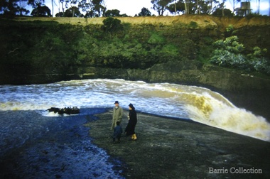
Photograph, Melton Weir, 1961
... Family at the spillway in flood...Melton City Libraries 31 McKenzie Street Melton melbourne Misc. Family at the spillway in flood Melton Weir Photograph Barrie Collection ...Family at the spillway in floodmisc. -
 Melton City Libraries
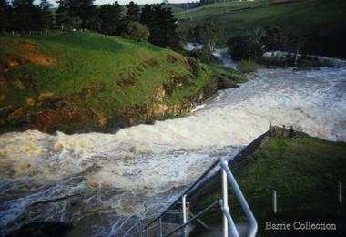
Photograph, Melton Weir, 1961
... Family at the spillway in flood...Melton City Libraries 31 McKenzie Street Melton melbourne Misc. Family at the spillway in flood Melton Weir Photograph Barrie Collection ...Family at the spillway in floodmisc. -
 Melton City Libraries
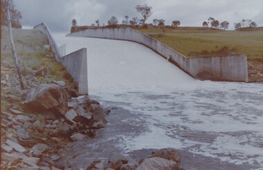
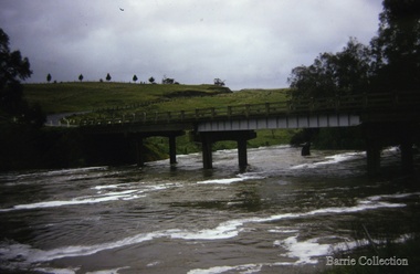
Photograph, Melton Weir, 1970
... Spillway, bridge and river in flood....Melton City Libraries 31 McKenzie Street Melton melbourne Misc. Spillway, bridge and river in flood. Melton Weir Photograph Barrie Collection ...Spillway, bridge and river in flood.misc. -
 Kew Historical Society Inc
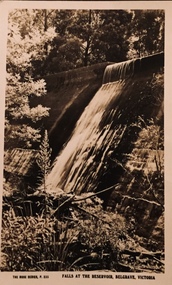
Postcard, Falls at the Reservoir, Belgrave, Victoria
... Monochrome postcard of the spillway at Belgrave....The postcards are part of a larger collection of photographs, postcards and publications donated to the collection in May 2021. postcards -- belgrave christian-washfold collection The Rose Series P. 335 Monochrome postcard of the spillway at Belgrave. Falls at the Reservoir, Belgrave, Victoria Postcard ...One of a number of 'real photo' and commercial postcards created by or owned by members of the Christian and Washfold families of Kew. The postcards are part of a larger collection of photographs, postcards and publications donated to the collection in May 2021.Monochrome postcard of the spillway at Belgrave.The Rose Series P. 335postcards -- belgrave, christian-washfold collection -
 Bendigo Historical Society Inc.
Slide - DAVID MCDONALD COLLECTION: EPPALOCK. CONSTRUCTION, c1963
... Picture of the blue water in Lake Eppalock, the road going over the spillway and the water going over the spillway....Picture of the blue water in Lake Eppalock, the road going over the spillway and the water going over the spillway. ...Eppalock. Construction. Picture of the blue water in Lake Eppalock, the road going over the spillway and the water going over the spillway.Agfacolorcivil engineering, water supply, eppalock -
 Bendigo Historical Society Inc.
Slide - DAVID MCDONALD COLLECTION: EPPALOCK. CONSTRUCTION, c1963
... Water flowing over the spillway....Water flowing over the spillway. Slide DAVID MCDONALD COLLECTION: EPPALOCK. ...Eppalock. Construction. Water flowing over the spillway.Agfacolorcivil engineering, water supply, eppalock -
 Bendigo Historical Society Inc.
Slide - LAANACOORIE;TARNAGULLA;MALDON, Sep 1960
... Slide, Laanacoorie;Tarnagulla;Maldon.Water over the spillway....Slide, Laanacoorie;Tarnagulla;Maldon.Water over the spillway. Slide LAANACOORIE;TARNAGULLA;MALDON. ...Slide, Laanacoorie;Tarnagulla;Maldon.Water over the spillway.slide, laanacoorie;tarnagulla;maldon., laanacoorie;tarnagulla;maldon. -
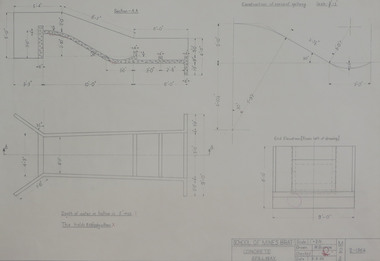 Federation University Historical Collection
Student's Technical Drawing, Technical drawing - concrete spillway, 1962
... Technical drawing - concrete spillway....Pencil on paper student's technical drawing of concrete spillway...Barker Library (top floor) Mount Helen goldfields mining engineering technical drawing w. a. burrow School of Mining Ballarat Pencil on paper student's technical drawing of concrete spillway Technical drawing - concrete spillway. ...Pencil on paper student's technical drawing of concrete spillwaymining engineering, technical drawing, w. a. burrow, school of mining ballarat -
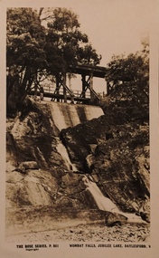 Kew Historical Society Inc
Postcard, Rose Stereograph Company, Wombat Falls, Jubilee Lake, Daylesford, 1920s
... Monochrome postcard of the spillway and Wombat Falls at Jubilee Lake...The postcards are part of a larger collection of photographs, postcards and publications donated to the collection in May 2021. wombat falls postcards -- daylesford christian-washfold collection The Rose Series P. 851 Monochrome postcard of the spillway and Wombat Falls at Jubilee Lake Wombat Falls, Jubilee Lake, Daylesford Postcard Rose Stereograph Company ...One of a number of 'real photo' and commercial postcards created by or owned by members of the Christian and Washfold families of Kew. The postcards are part of a larger collection of photographs, postcards and publications donated to the collection in May 2021.Monochrome postcard of the spillway and Wombat Falls at Jubilee LakeThe Rose Series P. 851wombat falls, postcards -- daylesford, christian-washfold collection -
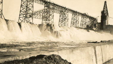 The Beechworth Burke Museum
Photograph, 25 October 1930
... Reverse: 84-19-6/ 1997.3187/ The spillway [featuring trademark: kodak print] ...The Dam was named after Hamilton Hume, who is an important historical figure for this area as he helped discover the area where resources were found. construction houses veterans Mitta Junction Village Hume Dam World War I Federation Wodonga Archaeological survey excavation Austral Archaeology Department of Land & Water Conservation Camp Ganger's Quarter's Stableman's Quarters Industrial Dump artefacts Mitta Mitta Mount Welcome Mount Misery Murray River Hamilton Hume William Hilton Hovell Hume and Hovell expedition Reverse: 84-19-6/ 1997.3187/ The spillway [featuring trademark: kodak print] Sepia rectangular photograph printed unmounted Photograph Photograph ...Taken on 25 October 1930, various houses with the Hume Dam under construction are depicted in the background. The construction of the Hume Dam took place from 1919 to 1936. At the time of construction, it was the second largest dam in the world. It was also one of the earliest civil projects developed after the Federation. Some of the Dam workers consisted of World War I veterans. Dam workers often settled their families in Mitta Junction Village and Wodonga. Archaeological surveys were completed by Austral Archaeology, which was done when the Department of Land & Water Conservation was doing work to improve Hume Dam. The archaeological report that came out of the survey recommended three sites of interest where archaeological excavation should be done: Camp Ganger’s Quarters, Stableman’s Quarters, and the Industrial Dump. The excavation uncovered artefacts. Mitta Mitta: Mitta Mitta is situated between Mount Welcome and Mount Misery. It is named after the river that explorers Hume and Hovell discovered in 1824. The town would eventually become a huge gold mining town. Mitta Mitta is called Midamodunga by the local Indigenous peoples Wodonga: Wodonga is situated on the Murray River and is part of North East Victoria. Hume and Hovell: Hamilton Hume (1979-1873) and William Hilton Hovell (1786-1875). W. H. Hovell was born in Norfolk England and Hume was born in Parramatta, New South Wales Hovell and Hume undertook an exploration journey in 1824 and thought they discovered a river, which turned out to be the Murray River. They returned home in 1825, but returned to the area in 1826 and discovered coal in the area.This photo is historically significant as it shows the Hume Dam under construction in 1930. The Dam was named after Hamilton Hume, who is an important historical figure for this area as he helped discover the area where resources were found.Sepia rectangular photograph printed unmountedReverse: 84-19-6/ 1997.3187/ The spillway [featuring trademark: kodak print] construction, houses, veterans, mitta junction village, hume dam, world war i, federation, wodonga, archaeological survey, excavation, austral archaeology, department of land & water conservation, camp ganger's quarter's, stableman's quarters, industrial dump, artefacts, mitta mitta, mount welcome, mount misery, murray river, hamilton hume, william hilton hovell, hume and hovell expedition -
 Bendigo Historical Society Inc.
Slide - DAVID MCDONALD COLLECTION: EPPALOCK. CONSTRUCTION, c1963
... Water going down to the Campaspe River from the spillway....Water going down to the Campaspe River from the spillway. Slide DAVID MCDONALD COLLECTION: EPPALOCK. ...Eppalock. Construction. Water going down to the Campaspe River from the spillway.Agfacolorcivil engineering, water supply, eppalock -
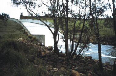
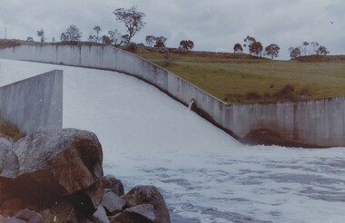
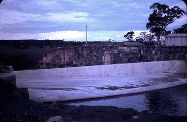
Malmsbury Historical Society
Photograph (Item), Western Spillway concrete Overflow, Malmsbury ca1990
... Western Spillway concrete Overflow, Malmsbury ca1990...Buildings - Concrete Spillway...Malmsbury Historical Society Malmsbury Mechanics Institute 71 Mollison Street Malmsbury daylesford-and-the-macedon-ranges Buildings - Concrete Spillway Western Spillway concrete Overflow, Malmsbury ca1990 Photograph Photograph ...Buildings - Concrete Spillway -
 Bendigo Historical Society Inc.
Slide - EPPALOCK. CONSTRUCTION, c1963
... Markings: Eppalock Spillway nearly over for the frist time, Sept 1963....Markings: Eppalock Spillway nearly over for the frist time, Sept 1963. ...Eppalock. Construction. Markings: Eppalock Spillway nearly over for the frist time, Sept 1963.Agfacolorcivil engineering, water supply, eppalock -
 Falls Creek Historical Society
Photograph - Bogong Alpine Village 1947
... Two black and white images capturing Bogong Village by night and the spillway at Junction Dam....Bogong Alpine Village Bogong High Plains Bogong 1947 Two black and white images capturing Bogong Village by night and the spillway at Junction Dam. Bogong Alpine Village 1947 Photograph Bogong Alpine Village 1947 ...The images in the Bogong Village Collection were displayed in Bogong Jack’s Tavern for over 20 years and were donated to the Falls Creek Museum when the Tavern closed in 2021. In 1939, the State Electricity Commission of Victoria established a field headquarters at Bogong to house workers and their families for the Kiewa Hydroelectric Scheme which ran from the 1930s to the 1960s. The workmen's camp was originally started with tents and was called Junction Camp. By 1947, the village supported 300 workers and their families. It included 40 houses, a hostel for single staff, a post office, a police station, a medical centre, and a primary school. The staff hostel was known as Kiewa House. At the completion of the Scheme, in the 1960s, the village was opened to public/tourism use. In 1968 the Victorian Education Department acquired the camp buildings and four houses from the State Electricity Commission of Victoria to establish an Outdoor Education Centre which operated for over 50 years. The Kiewa Hydroelectric Scheme was privatized in the 1990s and sold to Southern Hydro, before being acquired by AGL in 2005. In 2023 the Grollo Group signed a 73 year sublease on Bogong Village and has plans for its redevelopment as a workers’ village.These images are significant because they capture the development of Bogong Village as an important element of the Kiewa Hydroelectric Scheme in Victoria.Two black and white images capturing Bogong Village by night and the spillway at Junction Dam.bogong alpine village, bogong high plains, bogong 1947 -
Malmsbury Historical Society
Photograph (Item), New Spillway After Removal Of Blue Stone, Malmsbury ca1990
... New Spillway After Removal Of Blue Stone, Malmsbury ca1990...Buildings - New Spillway At Res....Malmsbury Historical Society Malmsbury Mechanics Institute 71 Mollison Street Malmsbury daylesford-and-the-macedon-ranges Buildings - New Spillway At Res. New Spillway After Removal Of Blue Stone, Malmsbury ca1990 Photograph Photograph ...Buildings - New Spillway At Res. -
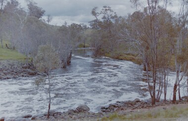
Stawell Historical Society Inc
Photograph, View to steps beside spillway Lake Lonsdale
... View to steps beside spillway Lake Lonsdale...View to steps beside spillway Lake Lonsdale...Stawell Historical Society Inc 46 Longfield St Stawell grampians View to steps beside spillway Lake Lonsdale Stawell View to steps beside spillway Lake Lonsdale Photograph ...View to steps beside spillway Lake Lonsdalestawell