Showing 128 items matching "spring creek bridge"
-
 Ballarat Heritage Services
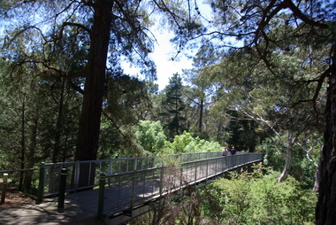
Photograph - Photograph - Colour, Spring Creek Bridge, Hepburn Springs, 2015, 25/10/2015
... Spring Creek Bridge, Hepburn Springs, 2015...spring creek bridge...The bridge over Spring Creek at Hepburn Springs....Ballarat Heritage Services PO Box 2209 Bakery Hill Post Office goldfields spring creek bridge hepburn springs bridge The bridge over Spring Creek at Hepburn Springs. ...The bridge over Spring Creek at Hepburn Springs.spring creek bridge, hepburn springs, bridge -
 Ballarat Heritage Services
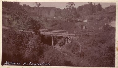
Photograph - Photograph - Black and White, Hepburn Near Daylesford
... Spring Creek...spring creek bridge...A timber bridge spanning Spring Creek at Hepburn Springs....Ballarat Heritage Services PO Box 2209 Bakery Hill Post Office goldfields daylesford Hepburn Springs Spring Creek spring creek bridge Mineral Springs Reserve A timber bridge spanning Spring Creek at Hepburn Springs. ...A timber bridge spanning Spring Creek at Hepburn Springs.daylesford, hepburn springs, spring creek, spring creek bridge, mineral springs reserve -
 Ballarat Heritage Services
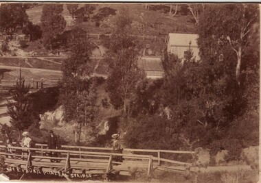
Photograph - Photograph - Black and White, Hepburn Mineral Spring
... spring creek...spring creek bridge...A number of people stand on a timber bridge which spans Spring Creek at Hepburn Springs. ...Ballarat Heritage Services PO Box 2209 Bakery Hill Post Office goldfields hepburn springs spring creek spring creek bridge hepburn mineral spring pavilion A number of people stand on a timber bridge which spans Spring Creek at Hepburn Springs. ...A number of people stand on a timber bridge which spans Spring Creek at Hepburn Springs. hepburn springs, spring creek, spring creek bridge, hepburn mineral spring, pavilion -
 Buninyong & District Historical Society
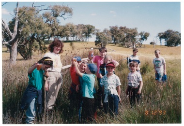
Photograph - Colour photograph of Clarendon State School excursion to Williamson's Creek 1993, Clarendon State School excursion to Williamson's Creek 1993
... Colour photo, Clarendon State School excursion to Mineral Springs, Burnt Bridge, Williamson's Creek 1993, last excursion before school closed, led by Ann Beggs Sunter...Buninyong & District Historical Society Old Court House, Buninyong Town Hall 313 Learmonth Street Buninyong goldfields Clarendon School excursion mineral springs Burnt Bridge Williamson's Creek Colour photo, Clarendon State School excursion to Mineral Springs, Burnt Bridge, Williamson's Creek 1993, last excursion before school closed, led by Ann Beggs Sunter Clarendon State School excursion to Williamson's Creek 1993 Photograph Colour photograph of Clarendon State School excursion to Williamson's Creek 1993 ...Colour photo, Clarendon State School excursion to Mineral Springs, Burnt Bridge, Williamson's Creek 1993, last excursion before school closed, led by Ann Beggs Sunterclarendon school, excursion, mineral springs, burnt bridge, williamson's creek -
 Bendigo Historical Society Inc.
Document - LONG GULLY HISTORY GROUP COLLECTION: THE BENDIGO POST OFFICE
... Creek Bridge... Cape Clear... Crooked Billet... Cambridgeshire Arms... Camp... Coach and Horses... Cricketers Arms... Diggers Rest... Ellesmere... Five Lions... Franklyn... Golden Square... Golden Gate... Golden Gully... Golden Age... Golden Vine... Gumtree... Glasgow Reef... Great Britain... Haymarket... Daniel O'Connell... Half Way House... Fleece Inn... Ironbark... Johnsons Reef... Lancashire... Live and Let Live... Manchester Arms... Gold Mines... Metropolitan... Crown... National... New Chum... Honeysuckle Street... Pavilion... Napier Arms... Quartz Miners Arms... Retreat Inn... Rainbow... Rose of Australia... Lake View... Robin Hood... Fountain... Southern Cross... Bath... Berlin... Spring...Names of the pubs are: The Freemasons, The Courthouse, The Commercial Law Courts, The Hamburg, The European, The Prince Bismark, The Lord Kitchener, The Bendigo, The Rosalind Park, The Showgrounds, Atheneum Club, Olivers, Bridge Hotel, Bourkes, The Globe, The Hibernia, Albert, Albion, Abbotts, Australian, Belvidere, Beehive, British Queen, Black Eagle, British and American, Brian Boru, Bakers Arms, Butchers Arms, Brick Layers Arms, Bull and Mouth, Cresent, Clarence, Back Creek Bridge, Cape Clear, Crooked Billet, Cambridgeshire Arms, Camp, Coach and Horses, Cricketers Arms, Diggers Rest, Ellesmere, Five Lions, Franklyn, Golden Square, Golden Gate, Golden Gully, Golden Age, Golden Vine, Gumtree, Glasgow Reef, Great Britain, Haymarket, Daniel O'Connell, Half Way House, Fleece Inn, Ironbark, Johnsons Reef, Lancashire, Live and Let Live, Manchester Arms, Gold Mines, Metropolitan, Crown, National, New Chum, Honeysuckle Street, Pavilion, Napier Arms, Quartz Miners Arms, Retreat Inn, Rainbow, Rose of Australia, Lake View, Robin Hood, Fountain, Southern Cross, Bath, Berlin, Spring Gully, Star, Sir Charles Hotham, Silvermines, Royal Oak, Suburban, Town Hall, Temperance, Ship Inn, View Point, View Bend, Victoria, Exchange, American, Arcade, Belfast, All Nations, Union, United Kingdom, Union Jack, Westend, Washington, Waterloo, Wellington, Whitehorse, Wheat Sheaf, Yorkshire, Niagra and Noahs Ark....Names of the pubs are: The Freemasons, The Courthouse, The Commercial Law Courts, The Hamburg, The European, The Prince Bismark, The Lord Kitchener, The Bendigo, The Rosalind Park, The Showgrounds, Atheneum Club, Olivers, Bridge Hotel, Bourkes, The Globe, The Hibernia, Albert, Albion, Abbotts, Australian, Belvidere, Beehive, British Queen, Black Eagle, British and American, Brian Boru, Bakers Arms, Butchers Arms, Brick Layers Arms, Bull and Mouth, Cresent, Clarence, Back Creek Bridge, Cape Clear, Crooked Billet, Cambridgeshire Arms, Camp, Coach and Horses, Cricketers Arms, Diggers Rest, Ellesmere, Five Lions, Franklyn, Golden Square, Golden Gate, Golden Gully, Golden Age, Golden Vine, Gumtree, Glasgow Reef, Great Britain, Haymarket, Daniel O'Connell, Half Way House, Fleece Inn, Ironbark, Johnsons Reef, Lancashire, Live and Let Live, Manchester Arms, Gold Mines, Metropolitan, Crown, National, New Chum, Honeysuckle Street, Pavilion, Napier Arms, Quartz Miners Arms, Retreat Inn, Rainbow, Rose of Australia, Lake View, Robin Hood, Fountain, Southern Cross, Bath, Berlin, Spring Gully, Star, Sir Charles Hotham, Silvermines, Royal Oak, Suburban, Town Hall, Temperance, Ship Inn, View Point, View Bend, Victoria, Exchange, American, Arcade, Belfast, All Nations, Union, United Kingdom, Union Jack, Westend, Washington, Waterloo, Wellington, Whitehorse, Wheat Sheaf, Yorkshire, Niagra and Noahs Ark. ...Article titled The Bendigo Post Office, compiled by L C Bennetts. Mentioned is the history of the Bendigo Post Office and postmarks, some information on mining, Bendigo foundries, Underground connections of mines, expenses and shaft sinking costs. Also mentioned is Bendigo and Eaglehawk - 60 years ago and the role the pubs played in daily living. They were where theatres, concerts and dances were held, and the meeting rooms for clubs and lodges, even church benefits. Listed is a number of Bendigo hotels. Some even had a few names. Names of the pubs are: The Freemasons, The Courthouse, The Commercial Law Courts, The Hamburg, The European, The Prince Bismark, The Lord Kitchener, The Bendigo, The Rosalind Park, The Showgrounds, Atheneum Club, Olivers, Bridge Hotel, Bourkes, The Globe, The Hibernia, Albert, Albion, Abbotts, Australian, Belvidere, Beehive, British Queen, Black Eagle, British and American, Brian Boru, Bakers Arms, Butchers Arms, Brick Layers Arms, Bull and Mouth, Cresent, Clarence, Back Creek Bridge, Cape Clear, Crooked Billet, Cambridgeshire Arms, Camp, Coach and Horses, Cricketers Arms, Diggers Rest, Ellesmere, Five Lions, Franklyn, Golden Square, Golden Gate, Golden Gully, Golden Age, Golden Vine, Gumtree, Glasgow Reef, Great Britain, Haymarket, Daniel O'Connell, Half Way House, Fleece Inn, Ironbark, Johnsons Reef, Lancashire, Live and Let Live, Manchester Arms, Gold Mines, Metropolitan, Crown, National, New Chum, Honeysuckle Street, Pavilion, Napier Arms, Quartz Miners Arms, Retreat Inn, Rainbow, Rose of Australia, Lake View, Robin Hood, Fountain, Southern Cross, Bath, Berlin, Spring Gully, Star, Sir Charles Hotham, Silvermines, Royal Oak, Suburban, Town Hall, Temperance, Ship Inn, View Point, View Bend, Victoria, Exchange, American, Arcade, Belfast, All Nations, Union, United Kingdom, Union Jack, Westend, Washington, Waterloo, Wellington, Whitehorse, Wheat Sheaf, Yorkshire, Niagra and Noahs Ark.bendigo, history, long gully history group, the long gully history group - the bendigo post office, l c bennetts, mt alexander post office, porcupine inn, cenotaph, pike or pyke, baby health centre, sandhurst post office, government survey office, queen elizabeth oval, sandhurst trustees company, mr h b briston, savings bank, telegraph office, the sub-treasury, sir henry brougham lock kcb, sir john nimmo mla, prince of wales group of mines, the new prince of wales, eaglehawk golf links, new prince of wales no 2, the whip and jersey, mines department, lansell's big 180, new chum and victoria mine and battery, new chum railway, koch's pioneer, south new moon, catherine reef united, new moon, the virginia, south bell vue, central nell gwynne, north nell gwynne, miner's phthisis, hercules engine house, ironbark, new chum syncline, hercules energetic, roberts & sons, harkness & co, horwoods, great southern, ulster, carlisle, lansells big 180, victoria quartz, new st mungo, duchess tribute, south devonshire, hopewell mine, saxby mine, mcnair & co, shamrock, mr king, burke and wills expedition, sandhurst hotel, courthouse, hiberian, the freemasons, the courthouse, the commercial law courts, the hamburg, the european, the prince bismark, the lord kitchener, the bendigo, the rosalind park, the showgrounds, atheneum club, olivers, bridge hotel, bourkes, the globe, the hibernia, albert, albion, abbotts, australian, belvidere, beehive, british queen, black eagle, british and american, brian boru, bakers arms, butchers arms, brick layers arms, bull and mouth, cresent, clarence, back creek bridge, cape clear, crooked billet, cambridgeshire arms, camp, coach and horses, cricketers arms, diggers rest, ellesmere, five lions, franklyn, golden square, golden gate, golden gully, golden age, golden vine, gumtree, glasgow reef, great britain, haymarket, daniel o'connell, half way house, fleece inn, ironbark, johnsons reef, lancashire, live and let live, manchester arms, gold mines, metropolitan, crown, national, new chum, honeysuckle street, pavilion, napier arms, quartz miners arms, retreat inn, rainbow, rose of australia, lake view, robin hood, fountain, southern cross, bath, berlin, spring gully, star, sir charles hotham, silvermines, royal oak, suburban, town hall, temperance, ship inn, view point, view bend, victoria, exchange, american, arcade, belfast, all nations, union, united kingdom, union jack, westend, washington, waterloo, wellington, whitehorse, wheat sheaf, yorkshire, niagra, noahs ark -
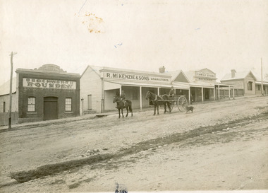 The Beechworth Burke Museum
Photograph, 1910
... Bridge road in Newtown, Beechworth. Walking on the road are two men on horseback, one of which is pulling a carriage with a small dog standing beside it. Behind them are a line of small buildings and shops. Small industries began to expand dramatically in Beechworth, particularly during the 1860s, leading to a strengthening of the towns economy. As early as 1853, areas surrounding the waterway known as Spring Creek...Bridge road in Newtown, Beechworth. Walking on the road are two men on horseback, one of which is pulling a carriage with a small dog standing beside it. Behind them are a line of small buildings and shops. Small industries began to expand dramatically in Beechworth, particularly during the 1860s, leading to a strengthening of the towns economy. As early as 1853, areas surrounding the waterway known as Spring Creek ...Taken in 1910, this photograph depicts a scene of Bridge road in Newtown, Beechworth. Walking on the road are two men on horseback, one of which is pulling a carriage with a small dog standing beside it. Behind them are a line of small buildings and shops. Small industries began to expand dramatically in Beechworth, particularly during the 1860s, leading to a strengthening of the towns economy. As early as 1853, areas surrounding the waterway known as Spring Creek were surveyed with the intent of mapping out plans for new roads and building allotments. Land was sold and new buildings were erected, creating an expansion of the Beechworth township and retail services. One building shown in this photograph is Straughair and Duncan's Beechworth Foundry. This business was established in 1858 through the partnership of Mark Straughair and John Duncan. It dealt mostly in the manufacturing of castings and mining machinery, receiving orders from all over the Ovens district. The Business eventually collapsed after the deaths of Straughair in 1882 and Duncan in 1896 but was reopened by W.H. Phillips in 1905. The two other buildings are both associated with the name McKenzie. Evidence suggests that the McKenzie family has a long association with the town of Beechworth. This photograph is historically significant as it provides insight into the nineteenth and twentieth century industrial expansions that happened in the area of Newtown, leading to the urbanisation of Beechworth. Black and white rectangular photograph printed on matte photographic paper mounted on card.Reverse: Newton / 1997.2648 / 33 Newton Beechworth / 84-219-1 / McKenzies / BMM3055 / newtown beechworth, bridge road, 1910, j. duncan, r. mckenzie, m. straughair, industrial growth, ford street, beechworth foundry, straughair and duncan, mckenzie and sons grainstore, mckenzie family store -
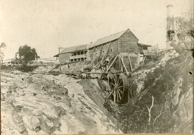 The Beechworth Burke Museum
Photograph, 1859
... The mill race and wheel are also clearly depicted, which may shed light onto how mill wheels of this era and place were constructed Chevalier Louis Chevalier Newtown Mill Grain Mill sawmill flour mill 1850s Beechworth Beechworth Council Farming and agriculture Victorian agricultural history Spring Creek buildings industry forestry Wood Timber Reverse: 3146 / 1997.2654 / Louis Chevalier's Flour Mill on / the Newtown Falls before the / Bridge / Est 1853 / this photo 1859 / 84-229-1 / Burke Museum Beechworth / Page 41 / 81 % / (Illegible) / (Illegible) 14 / Black and white rectangular photograph printed on matte photographic paper mounted on board Photograph Photograph ...Louis Chevalier, brother of popular artist Nicholas Chevalier, opened a sawmill in Beechworth near Spring Creek in Newtown in 1853. This facilitated a boom in building in the town, as materials were much more available than they had been previously. A second sawmill was opened in the town in 1856. Louis Chevalier served on the Beechworth Council as a representative of Newtown between 1858 and 1860. As this photograph is taken in 1859, the mill would have been operating as a sawmill at the time this photograph was taken. Louis Chevalier’s mill stopped sawing wood and began milling flour at some point between 1860 and 1862. At this time, the Oven’s district was almost self-sufficient, producing considerable quantities of grain, dairy, fodder and meat. Unfortunately, the region experienced poor agricultural yields in the 1880s and 1890s, which lead to the closure of the Beechworth Flour Mills in the 1880s. This photograph depicts the first sawmill in Beechworth, which was responsible for making the materials available for other early buildings in the town. The mill race and wheel are also clearly depicted, which may shed light onto how mill wheels of this era and place were constructedBlack and white rectangular photograph printed on matte photographic paper mounted on boardReverse: 3146 / 1997.2654 / Louis Chevalier's Flour Mill on / the Newtown Falls before the / Bridge / Est 1853 / this photo 1859 / 84-229-1 / Burke Museum Beechworth / Page 41 / 81 % / (Illegible) / (Illegible) 14 / chevalier, louis chevalier, newtown, mill, grain mill, sawmill, flour mill, 1850s beechworth, beechworth council, farming and agriculture, victorian agricultural history, spring creek, buildings, industry, forestry, wood, timber -
 The Beechworth Burke Museum
Photograph
... Taken in Beechworth, this photograph was taken from Albert road with a view of the bridge over spring creek. In the foreground, there appears three brothers who worked for Zwar tannery....The Beechworth Burke Museum Loch Street Beechworth high-country Taken in Beechworth, this photograph was taken from Albert road with a view of the bridge over spring creek. In the foreground, there appears three brothers who worked for Zwar tannery. beechworth albert road zwar tannery spring creek burke musuem photograph black and white Obverse: NO INSCRIPTION Reverse: 7591 Albert Rd. ...Taken in Beechworth, this photograph was taken from Albert road with a view of the bridge over spring creek. In the foreground, there appears three brothers who worked for Zwar tannery.Black and white rectangular photograph. The image is printed on matte photographic paper. Obverse: NO INSCRIPTION Reverse: 7591 Albert Rd. Italian family, 3 brothers worked for the tannery Copied from the albums of Sergio Santori, Wangaratta. beechworth, albert road, zwar, tannery, spring creek, burke musuem, photograph, black and white -
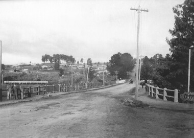
 The Beechworth Burke Museum
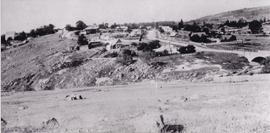
Photograph - Photograph - Reproduction, ca. 1900
... Bridge. Numerous early buildings line the road as it bifurcates to become Ford and High Streets on the ridge above Spring Creek and Newtown Falls. ...Bridge. Numerous early buildings line the road as it bifurcates to become Ford and High Streets on the ridge above Spring Creek and Newtown Falls. ...This image shows the approach to Beechworth from the south-west via the Newtown Bridge. Numerous early buildings line the road as it bifurcates to become Ford and High Streets on the ridge above Spring Creek and Newtown Falls. The sloping, rocky terrain and water course along the gorge show evidence of the intense mining activity that occurred at the site. The Ovens Gold Rush at Beechworth started when gold was found at Spring Creek in February 1852, prompting an influx of miners from around the world. The population grew over 20,000 by 1857. While the earliest mining at Beechworth was similar to that in other Victorian goldfields like Ballarat and Bendigo, Beechworth is notable for its use of hydraulic sluicing as a major method of removing wash-dirt. Hydraulic sluicing employs high pressure jets of water to blast away large areas of earth and wash it down to be run through a sluice box. Gold gets caught in the sluice and the remaining slurry is washed away. This method of mining is extremely effective but causes significant environmental impacts and damage to waterways. Large water quantities were required for large-scale sluicing, and the long water races and deep tailraces that were constructed in the Beechworth area in the nineteenth century are nonetheless considered feats of engineering. The site in the photograph is associated with the Rocky Mountain Mining Company who constructed an eight hundred meter tunnel under the township between 1876-1880 to reduce water levels at Spring Creek, which had been subject to diversions since the earliest days of alluvial mining. Over four million ounces of gold (115 tones) were found at Beechworth between 1852 and 1868, and the wealth from the gold rushes built Beechworth and the nationally significant buildings that remain standing today.This image shows the early development of the Beechworth township above Spring Creek, where gold was discovered in 1852. Evidence of hydraulic sluicing, a uniquely predominant method at Beechworth, and water-works engineering are present in the landscape. By the 1870s, alluvial gold deposits were depleted and increasingly complex engineering was required so deeper shafts could reach bedrock. This image is significant for understanding changes to the landscape and the evolution of mining methods and engineering practices related to the extensive construction, manipulation and management of water networks. The shift from smaller scale alluvial mining to larger company dominance in the mining industry has implications for understanding wider social, economic, political and industrial changes in the region of Beechworth and within the context of the Victorian Gold Rush more broadly. A black and white rectangular reproduction photograph printed on photographic paper. burke museum, beechworth museum, beechworth, gold fields, gold rush, victorian gold rush, hydraulic sluicing, rocky mountain mining company, spring creek, netwown falls, mining tunnels, water races, tailraces, colonial australia, australian gold rushes, mining technology, beechworth historic district, indigo gold trail, migration, indigo shire, gold mining, gold mining history -
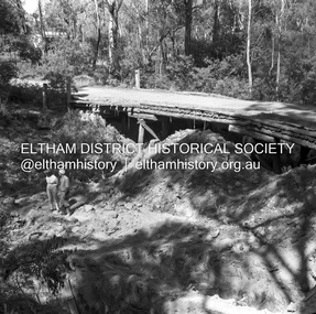
 Eltham District Historical Society Inc
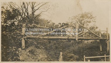
Photograph, "Curry, Byrne, McGeachy & self on rustic bridge, Eltham", 22 Oct 1919
... This photo depicts an outing with fellow VAD nurses McGeachy and Byrne and two patients of Mont Park, Curry and Caffery to Eltham in spring 1919 eltham diamond creek diamond street bridge alice elizabeth broadhurst byrne caffery curry mcgeachy nursing staff mont park 16 agh "Curry, Byrne, McGeachy & self on rustic bridge, Eltham, Oct 22, 1919" Digital file "Curry, Byrne, McGeachy & self on rustic bridge, Eltham" Photograph Photograph ...The old Diamond Street bridge in Eltham had a raised section seen here and a lower section, the railings of which can just be seen. The upper pedestrian crossing provided continual access for foot traffic during times of flood. This photo is part of the Alice Broadhurst collection held by Yarra Plenty Regional Library, a series of 12 photo albums compiled by Alice Broadhurst (1896-1981), initially while working as a Voluntary Aid Detachment nurse with the Australian Red Cross at the Mont Park Military Hospital (No. 16 AGH) and subsequently as a nurse at the Royal Melbourne and Royal Women’s hospitals alongside many pioneering doctors of their fields. This photo depicts an outing with fellow VAD nurses McGeachy and Byrne and two patients of Mont Park, Curry and Caffery to Eltham in spring 1919 Digital file"Curry, Byrne, McGeachy & self on rustic bridge, Eltham, Oct 22, 1919"eltham, diamond creek, diamond street bridge, alice elizabeth broadhurst, byrne, caffery, curry, mcgeachy, nursing staff, mont park, 16 agh -
 Eltham District Historical Society Inc
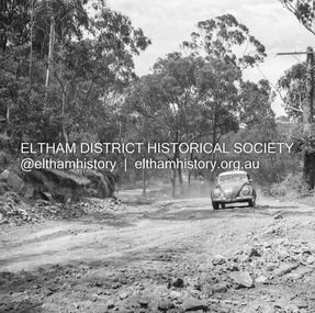
Negative - Photograph, J.A. McDonald, Heidelberg-Kinglake Road, Oct. 1959
... Infrastructure shire of eltham bridge construction Heidelberg-Kinglake Road 1959-10 Road construction Scan - 120 format 6x6 negative yow yow creek Medium format 120/Kodak 620 6x6 cm black and white negative (1 of 12) contained with Kodak processing envelope with various inscriptions and markings Originally inserted loose with other processing envelopes of negatives and prints within a binder of 78 foolscap pages containing a sequence of photos, adhered via glue or sticky tape, with typed or handwritten headings and captions in pencil, contained in a green foolscap binder with spring clasp spine for retaining loose pages. ...Job 56M431 Contractors Wolf and Wood Yow Yow Creek Bridge Showing condition October 1959 Bypass back upstream side under constructionRecord of various Shire of Eltham infrastructure works undertaken during the period of 1952-1962 involving bridge and road reconstruction projects, sometimes with Eltham Shire Council Project Reference numbers quoted. It was during this period that a number of significant improvements were made to roads and new bridges constructed within the shire that remain in place as of present day (2022). In many situations, the photos provide a tangible visible record of infrastructure that existed throughout the early days of the Shire. The album was put together by or under the direction of the Shire Engineer, J.A. McDonald.infrastructure, shire of eltham, bridge construction, heidelberg-kinglake road, 1959-10, road construction, scan - 120 format 6x6 negative, yow yow creek -
 Eltham District Historical Society Inc
Negative - Photograph, J.A. McDonald, Heidelberg-Kinglake Road, Oct. 1959
... Infrastructure shire of eltham bridge construction Heidelberg-Kinglake Road 1959-10 Road construction Scan - 120 format 6x6 negative yow yow creek Medium format 120/Kodak 620 6x6 cm black and white negative (1 of 12) contained with Kodak processing envelope with various inscriptions and markings Originally inserted loose with other processing envelopes of negatives and prints within a binder of 78 foolscap pages containing a sequence of photos, adhered via glue or sticky tape, with typed or handwritten headings and captions in pencil, contained in a green foolscap binder with spring clasp spine for retaining loose pages. ...Job 56M431 Contractors Wolf and Wood Yow Yow Creek Bridge Bypass road and bridge finished October 1959Record of various Shire of Eltham infrastructure works undertaken during the period of 1952-1962 involving bridge and road reconstruction projects, sometimes with Eltham Shire Council Project Reference numbers quoted. It was during this period that a number of significant improvements were made to roads and new bridges constructed within the shire that remain in place as of present day (2022). In many situations, the photos provide a tangible visible record of infrastructure that existed throughout the early days of the Shire. The album was put together by or under the direction of the Shire Engineer, J.A. McDonald.infrastructure, shire of eltham, bridge construction, heidelberg-kinglake road, 1959-10, road construction, scan - 120 format 6x6 negative, yow yow creek -
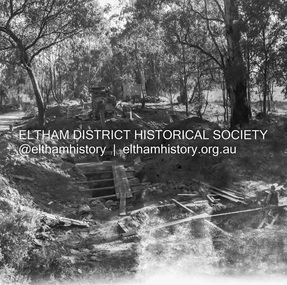
 Eltham District Historical Society Inc
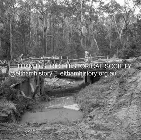
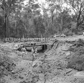
Negative - Photograph, J.A. McDonald, Heidelberg-Kinglake Road, 3 Nov. 1959
... Infrastructure shire of eltham bridge construction Heidelberg-Kinglake Road Road construction yow yow creek 1959-11-03 Medium format 120/Kodak 620 6x6 cm black and white negative (1 of 12) contained with Kodak processing envelope with various inscriptions and markings Originally inserted loose with other processing envelopes of negatives and prints within a binder of 78 foolscap pages containing a sequence of photos, adhered via glue or sticky tape, with typed or handwritten headings and captions in pencil, contained in a green foolscap binder with spring clasp spine for retaining loose pages. ...Job 56M431 Contractors Wolf and Wood Yow Yow Creek Bridge Curve improvement north of bridge site 3 November 1959Record of various Shire of Eltham infrastructure works undertaken during the period of 1952-1962 involving bridge and road reconstruction projects, sometimes with Eltham Shire Council Project Reference numbers quoted. It was during this period that a number of significant improvements were made to roads and new bridges constructed within the shire that remain in place as of present day (2022). In many situations, the photos provide a tangible visible record of infrastructure that existed throughout the early days of the Shire. The album was put together by or under the direction of the Shire Engineer, J.A. McDonald.infrastructure, shire of eltham, bridge construction, heidelberg-kinglake road, road construction, yow yow creek, 1959-11-03 -
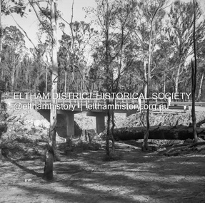
 Eltham District Historical Society Inc
Negative - Photograph, J.A. McDonald, Heidelberg-Kinglake Road, 3 Nov. 1959
... Infrastructure shire of eltham bridge construction Heidelberg-Kinglake Road Road construction yow yow creek 1959-11-03 Medium format 120/Kodak 620 6x6 cm black and white negative (1 of 12) contained with Kodak processing envelope with various inscriptions and markings Originally inserted loose with other processing envelopes of negatives and prints within a binder of 78 foolscap pages containing a sequence of photos, adhered via glue or sticky tape, with typed or handwritten headings and captions in pencil, contained in a green foolscap binder with spring clasp spine for retaining loose pages. ...Job 56M431 Contractors Wolf and Wood Yow Yow Creek Bridge Old bridge cut Temporary bridge in use 3 November 1959Record of various Shire of Eltham infrastructure works undertaken during the period of 1952-1962 involving bridge and road reconstruction projects, sometimes with Eltham Shire Council Project Reference numbers quoted. It was during this period that a number of significant improvements were made to roads and new bridges constructed within the shire that remain in place as of present day (2022). In many situations, the photos provide a tangible visible record of infrastructure that existed throughout the early days of the Shire. The album was put together by or under the direction of the Shire Engineer, J.A. McDonald.infrastructure, shire of eltham, bridge construction, heidelberg-kinglake road, road construction, yow yow creek, 1959-11-03 -
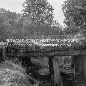
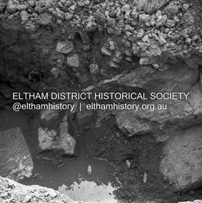 Eltham District Historical Society Inc
Negative - Photograph, J.A. McDonald, Heidelberg-Kinglake Road, 3 Nov. 1959
... Infrastructure shire of eltham bridge construction Heidelberg-Kinglake Road Road construction yow yow creek 1959-11 Medium format 120/Kodak 620 6x6 cm black and white negative (1 of 12) contained with Kodak processing envelope with various inscriptions and markings Originally inserted loose with other processing envelopes of negatives and prints within a binder of 78 foolscap pages containing a sequence of photos, adhered via glue or sticky tape, with typed or handwritten headings and captions in pencil, contained in a green foolscap binder with spring clasp spine for retaining loose pages. ...Job 56M431 Rock strata foundations This is what the bridge is founded on downstream side Kinglake abutment November 1959 Contractor W.E. WolfRecord of various Shire of Eltham infrastructure works undertaken during the period of 1952-1962 involving bridge and road reconstruction projects, sometimes with Eltham Shire Council Project Reference numbers quoted. It was during this period that a number of significant improvements were made to roads and new bridges constructed within the shire that remain in place as of present day (2022). In many situations, the photos provide a tangible visible record of infrastructure that existed throughout the early days of the Shire. The album was put together by or under the direction of the Shire Engineer, J.A. McDonald.infrastructure, shire of eltham, bridge construction, heidelberg-kinglake road, road construction, yow yow creek, 1959-11 -
 Eltham District Historical Society Inc
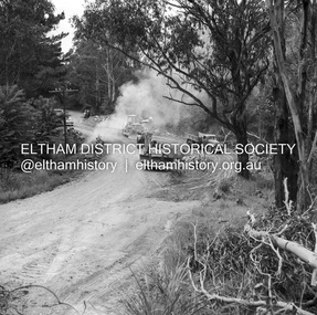
Negative - Photograph, J.A. McDonald, Hurstbridge-Arthurs Creek Road, Aug. 1960
... Blair Hurstbridge-Arthurs Creek Road bridge construction Road construction Medium format 120/Kodak 620 6x6 cm black and white negative (1 of 12) contained in envelope with various inscriptions and markings Originally inserted loose with other processing envelopes of negatives and prints within a binder of 78 foolscap pages containing a sequence of photos, adhered via glue or sticky tape, with typed or handwritten headings and captions in pencil, contained in a green foolscap binder with spring clasp spine for retaining loose pages. ...Laying culverts on boards A. Gillies, F. Wood, G. BlairRecord of various Shire of Eltham infrastructure works undertaken during the period of 1952-1962 involving bridge and road reconstruction projects, sometimes with Eltham Shire Council Project Reference numbers quoted. It was during this period that a number of significant improvements were made to roads and new bridges constructed within the shire that remain in place as of present day (2022). In many situations, the photos provide a tangible visible record of infrastructure that existed throughout the early days of the Shire. The album was put together by or under the direction of the Shire Engineer, J.A. McDonald.infrastructure, shire of eltham, 1960-08, a. gillies, f. wood, g. blair, hurstbridge-arthurs creek road, bridge construction, road construction -
 Eltham District Historical Society Inc
Negative - Photograph, J.A. McDonald, Hurstbridge-Arthurs Creek Road, Aug. 1960
... Infrastructure shire of eltham 1960-08 Hurstbridge-Arthurs Creek Road bridge construction Bulldozer Cranes Drott Road construction Medium format 120/Kodak 620 6x6 cm black and white negative (1 of 12) contained in envelope with various inscriptions and markings Originally inserted loose with other processing envelopes of negatives and prints within a binder of 78 foolscap pages containing a sequence of photos, adhered via glue or sticky tape, with typed or handwritten headings and captions in pencil, contained in a green foolscap binder with spring clasp spine for retaining loose pages. ...Culvert at Patullo’s CA 34H1 Sec. B, Parish of Greensborough F. Wood Drott and truck Council crane August 1960Record of various Shire of Eltham infrastructure works undertaken during the period of 1952-1962 involving bridge and road reconstruction projects, sometimes with Eltham Shire Council Project Reference numbers quoted. It was during this period that a number of significant improvements were made to roads and new bridges constructed within the shire that remain in place as of present day (2022). In many situations, the photos provide a tangible visible record of infrastructure that existed throughout the early days of the Shire. The album was put together by or under the direction of the Shire Engineer, J.A. McDonald.infrastructure, shire of eltham, 1960-08, hurstbridge-arthurs creek road, bridge construction, bulldozer, cranes, drott, road construction -
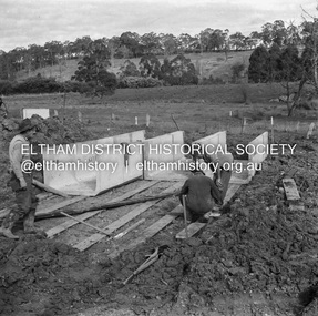
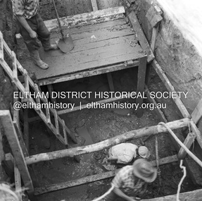
 Eltham District Historical Society Inc
Negative - Photograph, J.A. McDonald, Henley Road at Watsons Creek, Mar. 1961
... Bridge Watsons Creek W.E. Wolf bridge construction Road construction Medium format 120/Kodak 620 6x6 cm black and white negative (1 of 12) contained in envelope with various inscriptions and markings Originally inserted loose with other processing envelopes of negatives and prints within a binder of 78 foolscap pages containing a sequence of photos, adhered via glue or sticky tape, with typed or handwritten headings and captions in pencil, contained in a green foolscap binder with spring clasp spine for retaining loose pages. ...Old bridge over Watsons Creek 22 March 1961 Cr. Pelling and Contractor WolfRecord of various Shire of Eltham infrastructure works undertaken during the period of 1952-1962 involving bridge and road reconstruction projects, sometimes with Eltham Shire Council Project Reference numbers quoted. It was during this period that a number of significant improvements were made to roads and new bridges constructed within the shire that remain in place as of present day (2022). In many situations, the photos provide a tangible visible record of infrastructure that existed throughout the early days of the Shire. The album was put together by or under the direction of the Shire Engineer, J.A. McDonald.infrastructure, shire of eltham, 1961-03, bend of islands, cr. charis pelling, henley road, henley road bridge, kangaroo ground, oxley bridge, watsons creek, w.e. wolf, bridge construction, road construction -
 Eltham District Historical Society Inc
Negative - Photograph, J.A. McDonald, Henley Road at Watsons Creek, Mar. 1961
... Bridge Watsons Creek W.E. Wolf bridge construction Road construction Medium format 120/Kodak 620 6x6 cm black and white negative (1 of 12) contained in envelope with various inscriptions and markings Originally inserted loose with other processing envelopes of negatives and prints within a binder of 78 foolscap pages containing a sequence of photos, adhered via glue or sticky tape, with typed or handwritten headings and captions in pencil, contained in a green foolscap binder with spring clasp spine for retaining loose pages. ...Henley Road at Watsons Creek Looking easterly along new alignment, 22 March 1961 C. Browns Excavator Contractor Wolf Cr PellingRecord of various Shire of Eltham infrastructure works undertaken during the period of 1952-1962 involving bridge and road reconstruction projects, sometimes with Eltham Shire Council Project Reference numbers quoted. It was during this period that a number of significant improvements were made to roads and new bridges constructed within the shire that remain in place as of present day (2022). In many situations, the photos provide a tangible visible record of infrastructure that existed throughout the early days of the Shire. The album was put together by or under the direction of the Shire Engineer, J.A. McDonald.infrastructure, shire of eltham, 1961-03, bend of islands, cr. charis pelling, henley road, henley road bridge, kangaroo ground, oxley bridge, watsons creek, w.e. wolf, bridge construction, road construction -
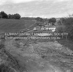
 Eltham District Historical Society Inc
Negative - Photograph, J.A. McDonald, Henley Road at Watsons Creek, Apr. 1961
... Bridge Watsons Creek W.E. Wolf bridge construction Road construction 1961-04 Medium format 120/Kodak 620 6x6 cm black and white negative (1 of 12) contained in envelope with various inscriptions and markings Originally inserted loose with other processing envelopes of negatives and prints within a binder of 78 foolscap pages containing a sequence of photos, adhered via glue or sticky tape, with typed or handwritten headings and captions in pencil, contained in a green foolscap binder with spring clasp spine for retaining loose pages. ...Henley Road at Watsons Creek looking easterly along centreline from west abutment Early April 1961Record of various Shire of Eltham infrastructure works undertaken during the period of 1952-1962 involving bridge and road reconstruction projects, sometimes with Eltham Shire Council Project Reference numbers quoted. It was during this period that a number of significant improvements were made to roads and new bridges constructed within the shire that remain in place as of present day (2022). In many situations, the photos provide a tangible visible record of infrastructure that existed throughout the early days of the Shire. The album was put together by or under the direction of the Shire Engineer, J.A. McDonald.infrastructure, shire of eltham, bend of islands, cr. charis pelling, henley road, henley road bridge, kangaroo ground, oxley bridge, watsons creek, w.e. wolf, bridge construction, road construction, 1961-04 -
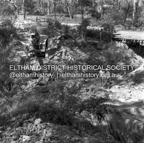
 Eltham District Historical Society Inc
Negative - Photograph, J.A. McDonald, Henley Road at Watsons Creek, Apr. 1961
... Bridge Watsons Creek W.E. Wolf bridge construction Road construction 1961-04 Medium format 120/Kodak 620 6x6 cm black and white negative (1 of 12) contained in envelope with various inscriptions and markings Originally inserted loose with other processing envelopes of negatives and prints within a binder of 78 foolscap pages containing a sequence of photos, adhered via glue or sticky tape, with typed or handwritten headings and captions in pencil, contained in a green foolscap binder with spring clasp spine for retaining loose pages. ...Henley Road at Watsons Creek showing excavation at western pier Rock at contract level, slight underground flow Early April 1961Record of various Shire of Eltham infrastructure works undertaken during the period of 1952-1962 involving bridge and road reconstruction projects, sometimes with Eltham Shire Council Project Reference numbers quoted. It was during this period that a number of significant improvements were made to roads and new bridges constructed within the shire that remain in place as of present day (2022). In many situations, the photos provide a tangible visible record of infrastructure that existed throughout the early days of the Shire. The album was put together by or under the direction of the Shire Engineer, J.A. McDonald.infrastructure, shire of eltham, bend of islands, cr. charis pelling, henley road, henley road bridge, kangaroo ground, oxley bridge, watsons creek, w.e. wolf, bridge construction, road construction, 1961-04 -
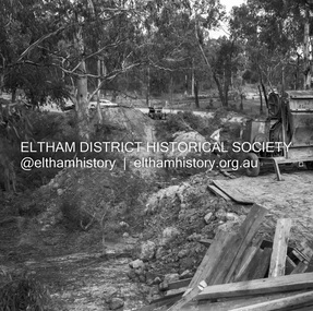
 Eltham District Historical Society Inc
Negative - Photograph, J.A. McDonald, Henley Road at Watsons Creek, Apr. 1961
... Bridge Watsons Creek W.E. Wolf bridge construction Road construction 1961-04 Medium format 120/Kodak 620 6x6 cm black and white negative (1 of 12) contained in envelope with various inscriptions and markings Originally inserted loose with other processing envelopes of negatives and prints within a binder of 78 foolscap pages containing a sequence of photos, adhered via glue or sticky tape, with typed or handwritten headings and captions in pencil, contained in a green foolscap binder with spring clasp spine for retaining loose pages. ...Henley Road at Watsons Creek looking westerly along centreline from east abutment Early April 1961Record of various Shire of Eltham infrastructure works undertaken during the period of 1952-1962 involving bridge and road reconstruction projects, sometimes with Eltham Shire Council Project Reference numbers quoted. It was during this period that a number of significant improvements were made to roads and new bridges constructed within the shire that remain in place as of present day (2022). In many situations, the photos provide a tangible visible record of infrastructure that existed throughout the early days of the Shire. The album was put together by or under the direction of the Shire Engineer, J.A. McDonald.infrastructure, shire of eltham, bend of islands, cr. charis pelling, henley road, henley road bridge, kangaroo ground, oxley bridge, watsons creek, w.e. wolf, bridge construction, road construction, 1961-04 -
 Eltham District Historical Society Inc
Negative - Photograph, J.A. McDonald, Henley Road at Watsons Creek, Apr. 1961
... Bridge Watsons Creek W.E. Wolf bridge construction Road construction 1961-04 Medium format 120/Kodak 620 6x6 cm black and white negative (1 of 12) contained in envelope with various inscriptions and markings Originally inserted loose with other processing envelopes of negatives and prints within a binder of 78 foolscap pages containing a sequence of photos, adhered via glue or sticky tape, with typed or handwritten headings and captions in pencil, contained in a green foolscap binder with spring clasp spine for retaining loose pages. ...Henley Road at Watsons Creek looking westerly showing west abutment excavation Mid April 1961Record of various Shire of Eltham infrastructure works undertaken during the period of 1952-1962 involving bridge and road reconstruction projects, sometimes with Eltham Shire Council Project Reference numbers quoted. It was during this period that a number of significant improvements were made to roads and new bridges constructed within the shire that remain in place as of present day (2022). In many situations, the photos provide a tangible visible record of infrastructure that existed throughout the early days of the Shire. The album was put together by or under the direction of the Shire Engineer, J.A. McDonald.infrastructure, shire of eltham, bend of islands, cr. charis pelling, henley road, henley road bridge, kangaroo ground, oxley bridge, watsons creek, w.e. wolf, bridge construction, road construction, 1961-04 -
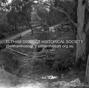
 Eltham District Historical Society Inc
Negative - Photograph, J.A. McDonald, Heidelberg-Kinglake Road, 11 May 1961
... McDonald. 1961-05-11 Heidelberg-Kinglake Road Infrastructure bridge construction shire of eltham yow yow creek Medium format 120/Kodak 620 6x6 cm black and white negative (1 of 12) contained in Kodak processing envelope with various inscriptions and markings Originally inserted loose with other processing envelopes of negatives and prints within a binder of 78 foolscap pages containing a sequence of photos, adhered via glue or sticky tape, with typed or handwritten headings and captions in pencil, contained in a green foolscap binder with spring clasp spine for retaining loose pages. ...Yow Yow Creek bridge 11 May 1961Record of various Shire of Eltham infrastructure works undertaken during the period of 1952-1962 involving bridge and road reconstruction projects, sometimes with Eltham Shire Council Project Reference numbers quoted. It was during this period that a number of significant improvements were made to roads and new bridges constructed within the shire that remain in place as of present day (2022). In many situations, the photos provide a tangible visible record of infrastructure that existed throughout the early days of the Shire. The album was put together by or under the direction of the Shire Engineer, J.A. McDonald.1961-05-11, heidelberg-kinglake road, infrastructure, bridge construction, shire of eltham, yow yow creek -
 Eltham District Historical Society Inc
Negative - Photograph, J.A. McDonald, Henley Road Bridge at Watsons Creek, c. May 1962
... Film process date 5 June 1962 Originally inserted loose with other processing envelopes of negatives and prints within a binder of 78 foolscap pages containing a sequence of photos, adhered via glue or sticky tape, with typed or handwritten headings and captions in pencil, contained in a green foolscap binder with spring clasp spine for retaining loose pages. Henley Road Bridge at Watsons Creek Negative Photograph J.A. ...Completed early January 1962Record of various Shire of Eltham infrastructure works undertaken during the period of 1952-1962 involving bridge and road reconstruction projects, sometimes with Eltham Shire Council Project Reference numbers quoted. It was during this period that a number of significant improvements were made to roads and new bridges constructed within the shire that remain in place as of present day (2022). In many situations, the photos provide a tangible visible record of infrastructure that existed throughout the early days of the Shire. The album was put together by or under the direction of the Shire Engineer, J.A. McDonald.1962-05, bend of islands, bridge construction, henley road, henley road bridge, infrastructure, kangaroo ground, oxley bridge, road construction, shire of eltham, watsons creek -
 Eltham District Historical Society Inc
Album - Photograph Album, J.A. McDonald, Bridge and Road Reconstruction Works, Shire of Eltham, 1952-1962
... Bridge silver street Sir Dallas Brooks Smedley property St Andrews Steels Creek Susan Street tarrawarra Tony Carberry Uniting Church Upper Yarra Dam Upper Yarra Reservoir W.E. Wolf Waterfall property Watsons Creek Wattletree Road Bridge Wattletree Road Wattletree Road Bridge Worlingworth Yarra Glen York Street yow yow creek 78 foolscap pages containing a sequence of photos, adhered via glue or sticky tape, with typed or handwritten headings and captions in pencil. Originally contained in a green foolscap binder with spring ...J.A. McDonald produced this record in the course of his responsibilities as Shire Engineer for Eltham Shire Council.Record of various Shire of Eltham infrastructure works undertaken during the period of 1952-1962 involving bridge and road reconstruction projects, sometimes with Eltham Shire Council Project Reference numbers quoted. It was during this period that a number of significant improvements were made to roads and new bridges constructed within the shire that remain in place as of present day (2022). In many situations, the photos provide a tangible visible record of infrastructure that existed throughout the early days of the Shire. The album was put together by or under the direction of the Shire Engineer, J.A. McDonald.a. gillies, alistair knox park, benchmark studies, bend of islands, blease road, box hill state school, box hill teachers college, box hill tip, bridge construction, bridge street bridge, bridge, brisbane street, brougham steet, bulldozer, cecil street, charis pelling, cherry tree road, city of preston, cr. a. brinkkotter, cr. charis pelling, cranes, cromwell street, diamond creek (creek), diamond street, dixons creek bridge, dixon's creek road, drott, eltham leisure centre, eltham north, eltham police station, eltham, eltham-yarra glen road, f. wood, fitzsimons lane bridge, flat rock road, flood damage, floods, floodwater, footpaths and gutters, ford service garage, g. blair, garden hill, glen park bridge, glenauburn road, grand hotel, haldane road, healesville, healesville-yarra glen road, heidelberg-kinglake road, henley road bridge, henley road, hill property, hurstbridge water scheme, hurstbridge, hurstbridge-arthurs creek road, infrastructure, j. jolly, kangaroo ground, kangaroo ground-queenstown road, kangaroo ground-st andrews road, lilydale shire office, long gully bridge, long gully creek, long gully road, long gully, lower plenty bridge, lower plenty footbridge, lower plenty oval, lower plenty road, lower plenty, main road, methodist church, montmorency, mount pleasant road, new holland, old healesville road, opening ceremony, oxley bridge, para road, paul creek bridge, paul creek road, paul krafeznk, pinnacle lane, plaques, plenty river trail, plenty river, presbyterian church, prof donald thomson, pryor street, railway crossing, railway parade, rattray road, reconstruction works, reichelt avenue, research (vic.), research oval, road construction, rymers corner, shire of eltham, shire of whittlesea, silvan road bridge, silver street bridge, silver street, sir dallas brooks, smedley property, st andrews, steels creek, susan street, tarrawarra, tony carberry, uniting church, upper yarra dam, upper yarra reservoir, w.e. wolf, waterfall property, watsons creek, wattletree road bridge, wattletree road, wattletree road bridge, worlingworth, yarra glen, york street, yow yow creek -
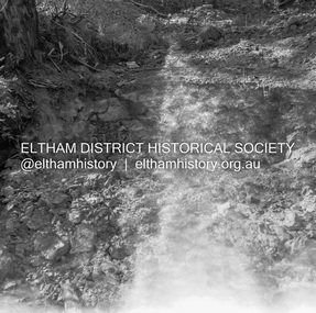
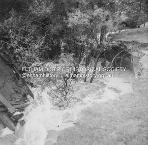 Eltham District Historical Society Inc
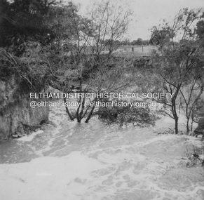
Album - Photograph, J.A. McDonald, Dixons Creek Road, 23 Sep. 1955
... McDonald. 1955-09-23 bridge construction Dixons Creek Bridge Dixon's Creek Road Flood damage floods Infrastructure Road construction shire of eltham Black and white photo print (location of negative unknown) Adhered to a page in an album of 78 foolscap pages containing a sequence of photos, adhered via glue or sticky tape, with typed or handwritten headings and captions in pencil. Originally contained in a green foolscap binder with spring ...Dixons Creek in floodRecord of various Shire of Eltham infrastructure works undertaken during the period of 1952-1962 involving bridge and road reconstruction projects, sometimes with Eltham Shire Council Project Reference numbers quoted. It was during this period that a number of significant improvements were made to roads and new bridges constructed within the shire that remain in place as of present day (2022). In many situations, the photos provide a tangible visible record of infrastructure that existed throughout the early days of the Shire. The album was put together by or under the direction of the Shire Engineer, J.A. McDonald.1955-09-23, bridge construction, dixons creek bridge, dixon's creek road, flood damage, floods, infrastructure, road construction, shire of eltham -
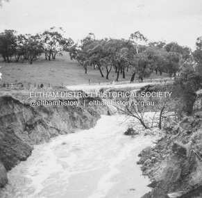 Eltham District Historical Society Inc
Album - Photograph, J.A. McDonald, Dixons Creek Road, 23 Sep. 1955
... McDonald. 1955-09-23 bridge construction Dixons Creek Bridge Dixon's Creek Road Flood damage floods Infrastructure Road construction shire of eltham Black and white photo print (location of negative unknown) Adhered to a page in an album of 78 foolscap pages containing a sequence of photos, adhered via glue or sticky tape, with typed or handwritten headings and captions in pencil. Originally contained in a green foolscap binder with spring ...Dixons Creek in floodRecord of various Shire of Eltham infrastructure works undertaken during the period of 1952-1962 involving bridge and road reconstruction projects, sometimes with Eltham Shire Council Project Reference numbers quoted. It was during this period that a number of significant improvements were made to roads and new bridges constructed within the shire that remain in place as of present day (2022). In many situations, the photos provide a tangible visible record of infrastructure that existed throughout the early days of the Shire. The album was put together by or under the direction of the Shire Engineer, J.A. McDonald.1955-09-23, bridge construction, dixons creek bridge, dixon's creek road, flood damage, floods, infrastructure, road construction, shire of eltham