Showing 4 items matching "stafford reef mine"
-
 Bendigo Historical Society Inc.
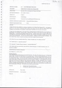
Document - STAFFORD REEF MINE SITE, DIAMOND HILL
... STAFFORD REEF MINE SITE, DIAMOND HILL......stafford reef mine...One page document describing the Stafford Reef Mine Site, Diamond Hill, Site 4.11, prepared by David Bannear. ...History House 11 Mackenzie Street Bendigo goldfields BENDIGO Mining stafford reef mine One page document describing the Stafford Reef Mine Site, Diamond Hill, Site 4.11, prepared by David Bannear. ...One page document describing the Stafford Reef Mine Site, Diamond Hill, Site 4.11, prepared by David Bannear. Information includes the map/grid references of the site and an overview of the history of the Stafford Reef Mine. The physical remains of the mine are described..bendigo, mining, stafford reef mine -
 Bendigo Historical Society Inc.
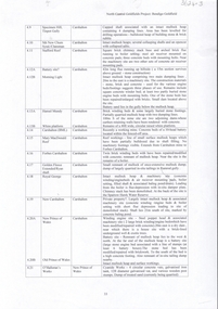
Document - CARSHALTON REEF, DIAMOND HILL MINES
... Table of information regarding the mines situated along the Carshalton line of Reef, includes Stafford Reef mine....History House 11 Mackenzie Street Bendigo goldfields BENDIGO Mining carshalton reef line Table of information regarding the mines situated along the Carshalton line of Reef, includes Stafford Reef mine. ...Table of information regarding the mines situated along the Carshalton line of Reef, includes Stafford Reef mine.bendigo, mining, carshalton reef line -
 Bendigo Historical Society Inc.
Map - SECTIONS ACROSS BENDIGO GOLDFIELD
... mines along the reef lines. Key shows rock types Castlemaine, Bendigo B1, B2, B3 and B4, and Lancefieldian. First part of map shows sections A-A, B-B and C-C. Reef lines drawn with mines listed: Fault line shown are the Carshalton, Stafford, New Chum, Virginia and Clarence. ...History House 11 Mackenzie Street Bendigo goldfields BENDIGO Gold mining reef line maps Geological Survey of Victoria Map in three sections showing sections across Bendigo Gold Field, showing anticlines, synclines, faults, stratigraphical zones and mines along the reef lines. Key shows rock types Castlemaine, Bendigo B1, B2, B3 and B4, and Lancefieldian. First part of map shows sections A-A, B-B and C-C. Reef lines drawn with mines listed: Fault line shown are the Carshalton, Stafford ...Map in three sections showing sections across Bendigo Gold Field, showing anticlines, synclines, faults, stratigraphical zones and mines along the reef lines. Key shows rock types Castlemaine, Bendigo B1, B2, B3 and B4, and Lancefieldian. First part of map shows sections A-A, B-B and C-C. Reef lines drawn with mines listed: Fault line shown are the Carshalton, Stafford, New Chum, Virginia and Clarence. A datum line shows 600 ft above sea level. On bottom of plan: ' Prepared in the Geological Survey Office, Bendigo, under the direction of H. Herman, late Director of Geological Survey, from surveys by H.S. Whitelaw, Field Geologist, assisted by E.S. Usher, A.J.J. Moore and R.A. Keble.' Second section of map shows sections D-D, and E-E. Fault lines listed are the Tambour Major fault, Carshalton fault, Stafford fault, Nell Gwynne fault, New Chum fault, Deborah fault. Third section shows sections F-F and G-G. Fault lines listed are the Bird Reef fault, Kangaroo Gully fault, Langdon fault, Carshalton fault, Nell Gwynne fault, Spring Gully fault, Hustlers fault, Gravel Hill fault, Ordes fault, Thanet fault. This map forms part of the Geological Survey of Victoria, Structure of Bendigo Goldfield report, No. 47, 1923. H.Herman, late Director of Geological Survey.Geological Survey of Victoriabendigo, gold mining, reef line maps -
 Bendigo Historical Society Inc.
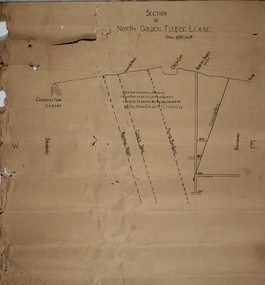
Plan - North Golden Fleece Lease, unknown
... Mine...Ramrod Reef...Comet Reef...Stafford...North Golden Fleece Gold Mine gold mining Bendigo lease holding Albert Gold Mine Ramrod Reef Comet Reef Stafford Reef and Frying Pan Reef Map drawn on heavy paper, titled 'Section of North Golden Fleece lease'. ...Map drawn on heavy paper, titled 'Section of North Golden Fleece lease'. Scale 80 ft to 1 inch. Written on plan in black print: 'This belt of country contains large bodies of auriferous quartz and at present is being operated on by the New Golden Fleece Company'. Reef lines marked on plan: Ramrod Reef, Comet Reef, Stafford Reef and Frying Pan Reef. The water race, Albert shaft and open cut are marked at the surface level. This plan is part of the Margaret Roberts Collection. north golden fleece gold mine, gold mining, bendigo, lease holding, albert gold mine, ramrod reef, comet reef, stafford reef and frying pan reef