Showing 4 items matching "star finder"
-
 Flagstaff Hill Maritime Museum and Village
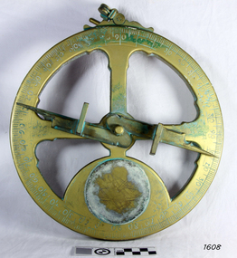
Instrument - Mariner's astrolabe
... ...Star finder...A mariner’s astrolabe or ‘star finder’ is a simplified version than that used by Arabic astronomers to find the altitude of the sun and stars above the horizon, and time of the sunrise and sunset. ...A mariner’s astrolabe or ‘star finder’ is a simplified version than that used by Arabic astronomers to find the altitude of the sun and stars above the horizon, and time of the sunrise and sunset. ...This representative example demonstrates a mariner’s astrolabe. Historical examples are rare. There are less than one hundred known to exist and most of these have been recovered from shipwrecks, many from Spanish and Portuguese vessels. An astrolabe is a measuring device once used to navigate the seas by observing the sun and stars to measure their altitude. The measurement of altitude could then be used to calculate the ship’s latitude but at that time in history there was no means of measuring longitude. The body of the navigational astrolabe was cast brass and much heavier, and less complicated than the variety used on land. The heavier weight and cut-away shape reduced the effect of the wind and waves when trying to use it at sea. A mariner’s astrolabe or ‘star finder’ is a simplified version than that used by Arabic astronomers to find the altitude of the sun and stars above the horizon, and time of the sunrise and sunset. It is a forerunner to the quadrant, octant and sextant and was popular for about 200 years over the 1500s and 1600s to find the latitude of a ship at sea. The user held the astrolabe at eye level and, usually with assistance, aligned the stars through the two small sights (pinnules), then read the altitude indicated by the pointer on the arm. It could also be used to sight the sun by holding it lower down, aiming it at the sun, and adjusting it until the sun shone through both pinnules. This astrolabe is an example used to demonstrate the mariner’s astrolabe, which was navigational tool of the 1500s and 1600s, in the time before longitude was able to be determined. It is a forerunner to modern navigation technology. Mariner’s astrolabe – a representative example. A gold painted, disc shaped object with cut outs and revolving arm in centre. The arm has two sights attached at right angles. The top has a ring attached. Measurements are marked in degrees in a circular scale around outer edge.flagstaff hill, warrnambool, maritime village, maritime museum, flagstaff hill maritime museum & village, shipwreck coast, great ocean road, navigation instrument, navigation tool, navigation, astrolabe, mariner’s astrolabe, measure latitude, measure altitude, arabic navigation, measuring device, star finder, astronomy, marine tool, marine instrument -
 Frankston RSL Sub Branch
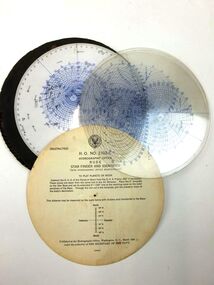
Star Identifier, US Hydrographic Office, March 1942
... rude star finder and identifier...It gives the positions of all stars included in both American and British Air Almanacs rude star finder and identifier Rude star identifier with hydrographic office modifications, A-N type 1, Hydrographic Office No 2102-C Rude star identifier with hydrographic office modifications, A-N type 1, with seven plastic transparent overlays, start and lunar location sheet, US Navy, circular, in vinyl cover Star Identifier US Hydrographic Office ...Star identifier used in air navigation. It gives the positions of all stars included in both American and British Air AlmanacsRude star identifier with hydrographic office modifications, A-N type 1, with seven plastic transparent overlays, start and lunar location sheet, US Navy, circular, in vinyl coverRude star identifier with hydrographic office modifications, A-N type 1, Hydrographic Office No 2102-Crude star finder and identifier -
 Moorabbin Air Museum
Equipment (item) - Rude Star Identifier with Hydrographic Modifications A N Type 1 Hydrographic Office No. 2102-C, Star Identifier
... This star finder, designed for aeronautical use, was based on the Rude form as modified by Elmer Collins of the United States Hydrographic Office. ...Moorabbin Air Museum Moorabbin Airport 12 First Street Moorabbin melbourne This star finder, designed for aeronautical use, was based on the Rude form as modified by Elmer Collins of the United States Hydrographic Office. ...This star finder, designed for aeronautical use, was based on the Rude form as modified by Elmer Collins of the United States Hydrographic Office. It consists of a white plastic planisphere with the northern sky on one side and the southern on the other that shows all the stars in the American and the British Air Almanacs; nine clear plastic altitude-azimuth templates for use at different latitudes up to 85° north and south; an instruction card; and a leatherette container. It was published in March 1942 under the authority of the Secretary of the Navy, and cost $2.50. -
 Ballarat RSL Sub-Branch Inc.
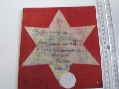
Flag - Segment Red with White Star laminated
... 6 pointed star (white star, red back ground) " this flag belong to Cpl. F. T Malone finder please send on to 324 Drummond Street Ballarat Victoria Australia"...Ballarat RSL Sub-Branch Inc. 330 Heinz Lane Invermay Park goldfields First World War (WW1) 1914 - 1918 Flags Ballarat RSL Ballarat 6 pointed star (white star, red back ground) " this flag belong to Cpl. F. T Malone finder please send on to 324 Drummond Street Ballarat Victoria Australia" Flag - Segment Red with White Star laminated ...6 pointed star (white star, red back ground) " this flag belong to Cpl. F. T Malone finder please send on to 324 Drummond Street Ballarat Victoria Australia"first world war (ww1), 1914 - 1918, flags, ballarat rsl, ballarat