Showing 391 items matching "state forest"
-
 Ballarat Heritage Services
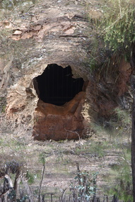
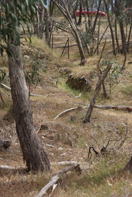
Photograph - Colour, Adit at Frenchman's Reef, Muckleford State Forest, 2017, 17/10/2017
... Adit at Frenchman's Reef, Muckleford State Forest, 2017...muckleford state forest...Colour photographs a tunnel at Frenchmans Reef in the Muckleford State Forest....Muckleford State Forest, Victoria, Australia...Ballarat Heritage Services PO Box 2209 Bakery Hill Post Office goldfields muckleford state forest goldfields mining tunnel Frenchman's Reef frenchmans reef Colour photographs a tunnel at Frenchmans Reef in the Muckleford State Forest. ...Colour photographs a tunnel at Frenchmans Reef in the Muckleford State Forest.muckleford state forest, goldfields, mining, tunnel, frenchman's reef, frenchmans reef -
 Ballan Shire Historical Society
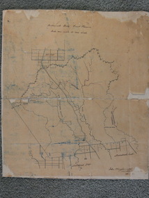
Map - Map. Bullarook State Forest, Bullarook State Forest Reserve
... Map. Bullarook State Forest....Bullarook State Forest Reserve.......state forest...A small map of the Bullarook State Forest Reserve. Drawn on a fine buff coloured paper attached to a stiff cloth backing sheet. ...Ballan Shire Historical Society 45-47 Steiglitz St Ballan goldfields moorabool west state forest bullarook eastern moorabool river werribee river moorabool east blakes saw mill wombat andersons saw mill A small map of the Bullarook State Forest Reserve. ...A small map of the Bullarook State Forest Reserve. Drawn on a fine buff coloured paper attached to a stiff cloth backing sheet. The title is hand written and includes a "scale one mile to one inch" hand written also. The map is signed "John Wrigglesworth, assistant ? and dated 26/6/1869" although the month and year are almost illegible.moorabool west, state forest, bullarook, eastern moorabool river, werribee river, moorabool east, blakes saw mill, wombat, andersons saw mill -
 Bendigo Military Museum
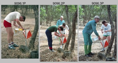
Photograph - Army Inter-area Orienteering Competition, Kimbolton State Forest, VIC, 1990
... Army Inter-area Orienteering Competition, Kimbolton State Forest, VIC...Army Inter-area Orienteering Competition, Kimbolton State Forest, VIC...This set of 29 photographs was taken during Army’s Inter-area Orienteering competition held in the Kimbolton State Forest, near Lake Eppalock, Victoria in 1990. ...This set of 29 photographs was taken during Army’s Inter-area Orienteering competition held in Kimbolton State Forest, near Lake Eppalock, Victoria in 1990. ...Army Inter-area Orienteering Competition, Kimbolton State Forest, VIC Photograph Army Inter-area Orienteering Competition, Kimbolton State Forest, VIC Army Survey Regiment ...This set of 29 photographs was taken during Army’s Inter-area Orienteering competition held in the Kimbolton State Forest, near Lake Eppalock, Victoria in 1990. Teams from Albury-Wodonga Bendigo, Broadmeadows, Melbourne Metropolitan, Puckapunyal and Watsonia participated in the annual competition. Bendigo’s Army Survey Regiment led by SGT Mick Minchin hosted the Orienteering events. This set of 29 photographs was taken during Army’s Inter-area Orienteering competition held in Kimbolton State Forest, near Lake Eppalock, Victoria in 1990. The colour photographs are on 35mm negative film and were scanned at 2400 dpi. They are part of the Army Survey Regiment’s Collection. .1) to .4) - Photo, colour, 1990, unidentified competitors. .5) - Photo, colour, 1990, L to R: unidentified competitor, Bendigo’s Janet Murray. .6) - Photo, colour, 1990, L to R: unidentified official, Le-Anne (Smallshaw) Shirley, Bendigo’s Janet Murray, unidentified competitors (x2). .7) to .8) - Photo, colour, 1990, unidentified competitors. .9) - Photo, colour, 1990, L to R: unidentified official, Mick Minchin. .10) to .11) - Photo, colour, 1990, Mick Minchin. .12) to .13) - Photo, colour, 1990, Bendigo’s Team L to R: Rene van den Tol, Wolfgang Hofbauer, Mick Minchin, Harris Lee, unidentified competitor, Allan Blake, Janet Murray. .14) & .15) - Photo, colour, 1990, presentations L to R: Rene van den Tol, unidentified competitor. .16) to .19) - Photo, colour, 1990, unidentified competitors. .20) - Photo, colour, 1990, presentations L to R: Rene van den Tol, unidentified competitor. .21) - Photo, colour, 1990, presentations L to R: Rene van den Tol, unidentified competitor, Mick Minchin. .22) - Photo, colour, 1990, BBQ L to R: unidentified (x2), Jeff Rudd, Rene van den Tol, Mick Minchin, Neville Stone, Steve Cooper. .23) - Photo, colour, 1990, BBQ, Wolfgang Hofbauer. .24) - Photo, colour, 1990, BBQ, Janet Murray - in black jacket. .25) - Photo, colour, 1990, BBQ, all unidentified. .26) - Photo, colour, 1990, BBQ, Neville Stone - in green t-shirt, Rene van den Tol in red track suit, remainder unidentified. .27) - Photo, colour, 1990, BBQ L to R: unidentified (x4), Janet Murray, Le-Anne (Smallshaw) Shirley, remainder unidentified. .28) & .29) - Photo, colour, 1990, views of Lake Eppalock.There are no personnel identified. ‘Inter-Area Orienteering 1990’ annotated on negative sleevesroyal australian survey corps, rasvy, army survey regiment, army svy regt, fortuna -
 Marysville & District Historical Society
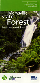
Ephemera (Item) - Information brochure, Department of Sustainability and Environment, Marysville State Forest, 2003
... Marysville State Forest......marysville state forest...An information brochure on various forest walks and drives throughout the Marysville State Forest that was published by the Victorian Department of Sustainability and Environment in 2003....An information brochure on various forest walks and drives throughout the Marysville State Forest that was published by the Victorian Department of Sustainability and Environment in 2003....Marysville State Forest Ephemera Information brochure Department of Sustainability and Environment ...An information brochure on various forest walks and drives throughout the Marysville State Forest that was published by the Victorian Department of Sustainability and Environment in 2003.An information brochure on various forest walks and drives throughout the Marysville State Forest that was published by the Victorian Department of Sustainability and Environment in 2003.marysville, victoria, australia, information brochure, marysville state forest, lady talbot forest drive, taggerty river picnic area, the beeches, coupe loop, leadbeater's possum, beckter lookout, steavenson falls, marysville visitor information centre, department of sustainability & environmnet, lake mountain, cambarville, yarra ranges national park, cathedral range state park, murrindindi scenic reserve, gilberts gully loop, beauty spot nature trail, trestle track, michaeldene track, keppel lookout, marysville tour -
 Bendigo Historical Society Inc.
Map - KAMAROOKA STATE FOREST, 23/11/1910
... KAMAROOKA STATE FOREST......Kamarooka State Forest...Map: Part of Subdivision of kamarooka State Forest, Parishes of Neilborough and Whirrakee, County of Bendigo. ...History House 11 Mackenzie Street Bendigo goldfields MAP Bendigo subdivision Kamarooka State Forest Subdivision Whirrakee Map: Part of Subdivision of kamarooka State Forest, Parishes of Neilborough and Whirrakee, County of Bendigo. ...Map: Part of Subdivision of kamarooka State Forest, Parishes of Neilborough and Whirrakee, County of Bendigo. Parish plan (number 287 in map cupboard 1)map, bendigo, subdivision, kamarooka state forest, subdivision, whirrakee -
 Ballarat Heritage Services
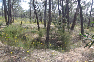
Photograph - Colour, Clare Gervasoni, Former Goldfield in the Muckleford State Forest, 2017, 17/10/2017
... Former Goldfield in the Muckleford State Forest, 2017...muckleford state forest...Colour photographs showing former goldminig sights in the Muckleford State Forest....Ballarat Heritage Services PO Box 2209 Bakery Hill Post Office goldfields muckleford state forest goldfields mining Colour photographs showing former goldminig sights in the Muckleford State Forest. ...Colour photographs showing former goldminig sights in the Muckleford State Forest.muckleford state forest, goldfields, mining -
 Ballarat Heritage Services
Photograph - Colour, Clare Gervasoni, Former Goldfield in the Muckleford State Forest, 2017, 17/10/2017
... Former Goldfield in the Muckleford State Forest, 2017...muckleford state forest...Colour photographs showing former goldminig sights in the Muckleford State Forest....Ballarat Heritage Services PO Box 2209 Bakery Hill Post Office goldfields muckleford state forest goldfields mining Colour photographs showing former goldminig sights in the Muckleford State Forest. ...Colour photographs showing former goldminig sights in the Muckleford State Forest.muckleford state forest, goldfields, mining -
Lakes Entrance Historical Society
Map - Naming East Gippsland's State Forest, Dept of Sustanability and Environmant, 2005
... Naming East Gippsland's State Forest ...Map shows the proposed State forest and change of current forest names. 2 pages...Lakes Entrance Historical Society 4 Marine Parade Lakes Entrance gippsland Maps Forest Map shows the proposed State forest and change of current forest names. 2 pages Map Naming East Gippsland's State Forest Dept of Sustanability and Environmant ...Map shows the proposed State forest and change of current forest names. 2 pagesmaps, forest -
 Mt Dandenong & District Historical Society Inc.
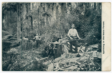
Photograph, Splitting In The State Forest, Early 1900s
... Splitting In The State Forest...On front of postcard: Splitting in the State Forest...Splitting In The State Forest Photograph ...Original postcard showing two men splitting wood in the forest at Mt Dandenong. They are using axes. Early 1900s.On front of postcard: Splitting in the State Forestwood chop, splitters, wood splitters, forest, mt dandenong, axes -
 Bendigo Historical Society Inc.
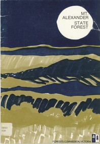
Book - MT. ALEXANDER STATE FOREST, 1979
... MT. ALEXANDER STATE FOREST...Mt Alexander State Forest 24 pages, with photographs and illustrations, maps. ...Book MT. ALEXANDER STATE FOREST ...Mt Alexander State Forest 24 pages, with photographs and illustrations, maps. Includes history of region, aboriginal history, flora and fauna. Painting illustrtaion on front cover.Forests Commission Victoriamt. alexander, natural history, mt. alexander, forest commission, natural history -
Federation University Historical Collection
Booklet, Little Desert National Park and Wail State Forest Proposed Management Plan, 1991, 11/1991
... Little Desert National Park and Wail State Forest Proposed Management Plan, 1991......wait state forest...Little Desert National Park and Wail State Forest Proposed Management Plan, 1991 Booklet ...Grey soft covered report of 80 pages. Includes a pull out map.little desert national park, wait state forest, management plan, horsham, department of conservation and environment, rod gowans, don spence, wimmera river, threatened plants, fauna, flora, birds, mammals, wergaia, scarred trees, mounds, pest plants, pest animals, tourism and recreation, timber, grazing, conservation -
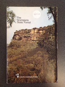 Stawell Historical Society Inc
Book, Forests Commission, The Grampians State Forest
... The Grampians State Forest...Upper right Text in black " The Grampians State Forest" Lower right a logo consisting of two vertical rectangles one black with a white tree, the other white with a black tree, Forests Commission, Victoria" In white Print beside logo...Stawell Historical Society Inc 46 Longfield St Stawell grampians stawell tourism Upper right Text in black " The Grampians State Forest" Lower right a logo consisting of two vertical rectangles one black with a white tree, the other white with a black tree, Forests Commission, Victoria" In white Print beside logo Cardboard cover Photograph showing the Grampians, with text upper right and lower right The Grampians State Forest Book Forests Commission ...Cardboard cover Photograph showing the Grampians, with text upper right and lower rightUpper right Text in black " The Grampians State Forest" Lower right a logo consisting of two vertical rectangles one black with a white tree, the other white with a black tree, Forests Commission, Victoria" In white Print beside logostawell tourism -
![Dandenong State Forest, at Fern Tree Gully / [by] Nicholas Caire, circa 1876](/media/collectors/550653872162f11fb04854aa/items/577750a4d0cdd10a5c15e22b/item-media/57775147d0cdd10a5c165a58/item-fit-380x285.jpg?cb=6) Kew Historical Society Inc
Kew Historical Society IncPhotograph, Anglo-Australasian Photographic Company, Dandenong State Forest, at Fern Tree Gully, c. 1876
... Dandenong State Forest, at Fern Tree Gully...printed in ink on support l.c.: DANDENONG STATE FOREST, AT FERN TREE GULLY. / COPYRIGHT REGISTERED. printed in ink on support reverse c.: VIEWS OF VICTORIA. / (GENERAL SERIES.) / No. 12. / DANDENONG STATE FOREST, AT FERN TREE GULLY. / Fern Tree Gully is one of the favourite resorts for pleasure-seekers on holiday occasions. ...Albumen silver photograph on board Dandenong State Forest, at Fern Tree Gully Photograph Photograph Anglo-Australasian Photographic Company ...Nicholas Caire was born on Guernsey in the Channel Islands in 1837. He arrived in Adelaide with his parents in about 1860. In 1867, following photographic journeys in Gippsland, he opened a studio in Adelaide. From 1870 to 1876 he lived and worked in Talbot in Central Victoria. In 1876 he purchased T. F. Chuck's studios in the Royal Arcade Melbourne. In 1885, following the introduction of dry plate photography, he began a series of landscape series, which were commercially successful. As a photographer, he travelled extensively through Victoria, photographing places few of his contemporaries had previously seen. He died in 1918. Reference: Jack Cato, 'Caire, Nicholas John (1837–1918)', Australian Dictionary of Biography, National Centre of Biography, Australian National UniversityAn original, rare photograph from the series 'Views of Victoria: General Series' by the photographer, Nicholas Caire (1837-1918). The series of 60 photographs that comprise the series was issued c. 1876 and reinforced a neo-Romantic view of the Australian landscape to which a growing nationalist movement would respond. Nicholas Caire was active as a photographer in Australia from 1858 until his death in 1918. His vision of the Australian bush and pioneer life had a counterpart in the works of Henry Lawson and other nationalist poets, authors and painters.Albumen silver photograph on boardprinted in ink on support l.c.: DANDENONG STATE FOREST, AT FERN TREE GULLY. / COPYRIGHT REGISTERED. printed in ink on support reverse c.: VIEWS OF VICTORIA. / (GENERAL SERIES.) / No. 12. / DANDENONG STATE FOREST, AT FERN TREE GULLY. / Fern Tree Gully is one of the favourite resorts for pleasure-seekers on holiday occasions. This scene is taken / from the camping ground at the entrance to the Gully. The residence in the centre of the picture is that of the / Forest-keeper, Mr. Kennedy, who has charge of the Dandenong State Forest. The trees on the hill at the back of / the residence, through apparently diminutive, are in reality gigantic ones, measuring in many instances from 15 to / 20 feet in circumference at the base. printed in ink on support reverse l.c.l.: J.W. FORBES, Agent, printed in ink on support reverse l.c.: ANGLO-AUSTRALASIAN PHOTOGRAPHIC COMPANY, MELBOURNE. printed in ink on support reverse l.c.r.: 10 Temple Court, Collins Street West.nicholas caire (1837-1918), landscape photography, ferntree gully -
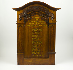 Department of Energy, Environment and Climate Action
Roll of Honour, State Forest Department
... State Forest Department ...This board lists the names of 20 people from the State Forests Department who enlisted in WW1. ...This board lists the names of 20 people from the State Forests Department who enlisted in WW1. ...Honour boards and rolls were erected in many local schools, halls, churches and offices as a means of acknowledging the commitment made by the community to the military forces. The criteria used for inclusion of names on an honour board were determined by those creating the board and can vary. This board lists the names of 20 people from the State Forests Department who enlisted in WW1. The most significant name is Albert Jacka VC who was perhaps Australia’s finest fighting soldier, and has the honour of being the first Australian to be awarded the Victoria Cross during WW1, the highest decoration for gallantry in the face of the enemy. Most of the other names have been researched. Jacka's name and image was used in a recruitment poster for the war.Roll of HonourMembers of the Forest Service of Victoria who enlisted & went to The Great War 1914 - 1919forests commission victoria (fcv) -
 Ballarat Heritage Services
Photograph - Colour, Clare Gervasoni, Thornhill Reef Quartz Roasting Kilns, 2017, 17/10/2017
... muckleford state forest...Colour photographs of the Thornhill Reef Quartz Roasting Kilns in the Muckleford State Forest....Ballarat Heritage Services PO Box 2209 Bakery Hill Post Office goldfields muckleford state forest goldfields mining Colour photographs of the Thornhill Reef Quartz Roasting Kilns in the Muckleford State Forest. ...Colour photographs of the Thornhill Reef Quartz Roasting Kilns in the Muckleford State Forest.muckleford state forest, goldfields, mining -
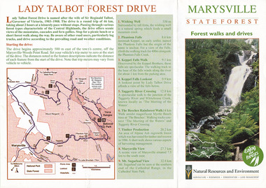
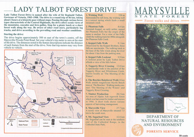 Marysville & District Historical Society
Flyer (item) - Brochure, Department of Natural Resources and Environment-Forest Service, Marysville State Forest-Forest walks and drives-Lady Talbot Forest Drive, Pre 2009
... Marysville State Forest-Forest walks and drives-Lady Talbot Forest Drive...Lady Talbot Drive is named after Lady Sarah Elizabeth, the wife of Sir Reginald Talbot, who was the Governor of Victoria from 25th April, 1904 to 6th July 1908. lady talbot forest drive lady talbot drive sir reginald talbot lady sarah elizabeth talbot marysville wishing well phantom falls keppel falls walk keppel falls lookout taggerty river beeches rainforest walk logging mount sugarloaf victoria 50 cents Bob McNamara/ Real Estate Agent/ Tourism Info Centre Co-Ordinator A brochure that was produced as a guide to Lady Talbot Forest Drive in Marysville in Victoria. Marysville State Forest-Forest walks and drives-Lady Talbot Forest Drive Flyer Brochure Department of Natural Resources and Environment-Forest Service ...A brochure that was produced as a guide to Lady Talbot Forest Drive in Marysville in Victoria.A brochure that was produced as a guide to Lady Talbot Forest Drive in Marysville in Victoria. Lady Talbot Drive a 24 kilometer scenic rainforest car journey which passes a number of walks and waterfalls in the Yarra Ranges National Park. Lady Talbot Drive is named after Lady Sarah Elizabeth, the wife of Sir Reginald Talbot, who was the Governor of Victoria from 25th April, 1904 to 6th July 1908.50 cents Bob McNamara/ Real Estate Agent/ Tourism Info Centre Co-Ordinatorlady talbot forest drive, lady talbot drive, sir reginald talbot, lady sarah elizabeth talbot, marysville, wishing well, phantom falls, keppel falls walk, keppel falls lookout, taggerty river, beeches rainforest walk, logging, mount sugarloaf, victoria -
 Marysville & District Historical Society
Flyer (item) - Brochure, Natural Resources and Evironment, Marysville State Forest-Forest walks and drives-Lady Talbot Forest Drive, Pre 2009
... Marysville State Forest-Forest walks and drives-Lady Talbot Forest Drive...Lady Talbot Drive is named after Lady Sarah Elizabeth, the wife of Sir Reginald Talbot, who was the Governor of Victoria from 25th April, 1904 to 6th July 1908. lady talbot forest drive lady talbot drive sir reginald talbot lady sarah elizabeth talbot marysville wishing well phantom falls keppel falls walk keppel falls lookout taggerty river beeches rainforest walk logging mount sugarloaf victoria A brochure that was produced as a guide to Lady Talbot Forest Drive in Marysville in Victoria. Marysville State Forest-Forest walks and drives-Lady Talbot Forest Drive Flyer Brochure Natural Resources and Evironment ...A brochure that was produced as a guide to Lady Talbot Forest Drive in Marysville in Victoria.A brochure that was produced as a guide to Lady Talbot Forest Drive in Marysville in Victoria. Lady Talbot Drive a 24 kilometer scenic rainforest car journey which passes a number of walks and waterfalls in the Yarra Ranges National Park. Lady Talbot Drive is named after Lady Sarah Elizabeth, the wife of Sir Reginald Talbot, who was the Governor of Victoria from 25th April, 1904 to 6th July 1908.lady talbot forest drive, lady talbot drive, sir reginald talbot, lady sarah elizabeth talbot, marysville, wishing well, phantom falls, keppel falls walk, keppel falls lookout, taggerty river, beeches rainforest walk, logging, mount sugarloaf, victoria -
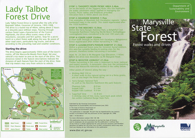 Marysville & District Historical Society
Flyer (item) - Brochure, Dept. Sustainability & Environment, Marysville State Forest-Forest walks and drives-Lady Talbot Forest Drive, 2003
... Marysville State Forest-Forest walks and drives-Lady Talbot Forest Drive...Lady Talbot Drive is named after Lady Sarah Elizabeth, the wife of Sir Reginald Talbot, who was the Governor of Victoria from 25th April, 1904 to 6th July 1908. lady talbot forest drive lady talbot drive sir reginald talbot lady sarah elizabeth talbot marysville wishing well phantom falls keppel falls walk keppel falls lookout taggerty river beeches rainforest walk logging mount sugarloaf victoria leadbeater's possum beckter lookout steavenson falls isbn 1 74106 695 6 ISBN 1 74106 695 6 A brochure that was produced as a guide to Lady Talbot Forest Drive in Marysville in Victoria. Marysville State Forest-Forest walks and drives-Lady Talbot Forest Drive Flyer Brochure Dept. ...A brochure that was produced as a guide to Lady Talbot Forest Drive in Marysville in Victoria.A brochure that was produced as a guide to Lady Talbot Forest Drive in Marysville in Victoria. Lady Talbot Drive a 24 kilometer scenic rainforest car journey which passes a number of walks and waterfalls in the Yarra Ranges National Park. Lady Talbot Drive is named after Lady Sarah Elizabeth, the wife of Sir Reginald Talbot, who was the Governor of Victoria from 25th April, 1904 to 6th July 1908.ISBN 1 74106 695 6lady talbot forest drive, lady talbot drive, sir reginald talbot, lady sarah elizabeth talbot, marysville, wishing well, phantom falls, keppel falls walk, keppel falls lookout, taggerty river, beeches rainforest walk, logging, mount sugarloaf, victoria, leadbeater's possum, beckter lookout, steavenson falls, isbn 1 74106 695 6 -
 Ballarat Heritage Services
Photograph - Colour, Red, White and Blue Mine near Maldon, 2017, 17/10/2017
... ...muckleford state forest...Colour photograph of the Red, White and Blue historic mine site in the Muckleford State Forest, showing an intact poppet head with tubular steel legs, winding wheels and remains of timberwork....It was also known as the Golden Age Mine and as Malney's Red, White and Blue Mine. red, white and blue mine maldon golden age mine maloney's red, white and blue muckleford state forest Colour photograph of the Red, White and Blue historic mine site in the Muckleford State Forest, showing an intact poppet head with tubular steel legs, winding wheels and remains of timberwork. ...The Red, White and Blue mine is a site of historical, areaological and scientific importance to Victoria, and is listed on the Victorian Heritage Register of significant heritage places. It was also known as the Golden Age Mine and as Malney's Red, White and Blue Mine. Colour photograph of the Red, White and Blue historic mine site in the Muckleford State Forest, showing an intact poppet head with tubular steel legs, winding wheels and remains of timberwork.red, white and blue mine, maldon, golden age mine, maloney's red, white and blue, muckleford state forest -
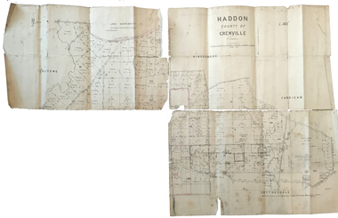 Federation University Historical Collection
Plan, Haddon County of Grenville, 1887, 1887
... ...haddon state forest...Parish Plan of Haddon showing the township of Haddon, Cardigan and Haddon State Forest, Lake Burrumbeet and Nentingbook Pre-emptive Right. ...Cunningham Applic' Parish Plan of Haddon showing the township of Haddon, Cardigan and Haddon State Forest, Lake Burrumbeet and Nentingbook Pre-emptive Right. ...Parish Plan of Haddon showing the township of Haddon, Cardigan and Haddon State Forest, Lake Burrumbeet and Nentingbook Pre-emptive Right. Names on the allotments include H. Cuthbert, B. Hepburn, T.W. Lloyd, J. Palmer, E.A. Wynne, William Collard Smith, A. Porteous, P. Russell, J. Mitchell, G. Renniehandwritten 'J. H. Cunningham Applic'haddon, cardigan, haddon state forest, lake burrumbeet, nentingbook pre-emptive right, h. cuthbert, b. hepburn, t.w. lloyd, j. palmer, e.a. wynne, william collard smith, a. porteous, p. russell, j. mitchell, g. rennie, j. noone, department of lands and survey -
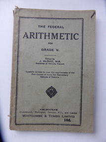 Warrnambool and District Historical Society Inc.
Book, The Federal Arithmetic, Early 20th century
... ...allans forest state school...The Bonnett family farmed in the Mepunga area on the Childers Cove Road. The Allans Forest State School, number 1086, was established in 1871 and closed in 1993. ...Bonnett, Allans Forest State School’...This book is significant because it was used by George Bonnett at the Allans Forest State School and is a memento of both the Bonnett family of Mepunga and the Allans Forest State School, a school no longer existing. ...This is a Grade V Arithmetic book used by George Bonnett at Allans Forest School. The Bonnett family farmed in the Mepunga area on the Childers Cove Road. The Allans Forest State School, number 1086, was established in 1871 and closed in 1993. The first Head Teacher was Mr Bradhurst. The school closed in 1903 and re-opened in 1905 as a half-time school with Mepunga East and in 1908 it resumed as a full time school. This book is significant because it was used by George Bonnett at the Allans Forest State School and is a memento of both the Bonnett family of Mepunga and the Allans Forest State School, a school no longer existing. It is also of antiquarian interest as an example of arithmetic school text books used early in the 20th century. This is soft cover book of 128 pages. The cover is grey with black print and black lines around the edges of the front cover. The book has a prefatory note, arithmetical exercises and advertisements for other school text books published by Whitcombe and Tombs. The cover is torn and soiled and partly ripped away. There is handwriting in black ink on the first page.‘George H. Bonnett, Allans Forest State School’bonnett family, mepunga, allans forest state school, warrnambool history -
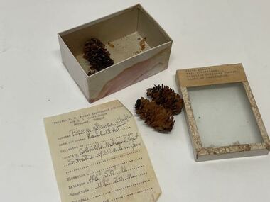 Creswick Campus Historical Collection - University of Melbourne
Plant specimen - Plant Specimen from the VSF Herbarium, Picea glauca. Var. albertiana. Colville National Forest. State of Washington
... Colville National Forest. State of Washington....Colville National Forest. State of Washington.. Note inside: Pacific N.W. ...Colville National Forest. State of Washington.. Note inside: Pacific N.W. ...Plant Specimen from the VSF Herbarium - seeds in a cardboard box with a glass lidBox: Picea glauca. Var. albertiana. Colville National Forest. State of Washington.. Note inside: Pacific N.W. Forest Experiment Station 424 U.S. Court House, Portland Oregon. Species: Picea glauca albertiana. Date colledted: Fall 1935. Latitude: 40/50 N. Longitude: 119/20 W. -
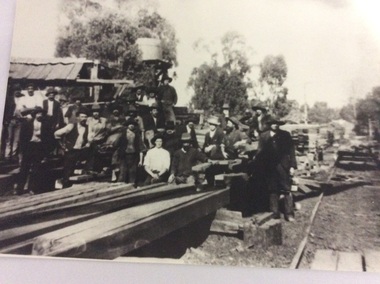 Port of Echuca
Black and white photograph
... ...Banyule State Forest...Macintosh's sawmill was on the banks of the Murray River in Echuca east where the Banyule State forest is now located. A tramway ran out to it from the main rail line near the iron bridge. ...Port of Echuca 74 Murray Esplanade Echuca the-murray Macintosh's sawmill was on the banks of the Murray River in Echuca east where the Banyule State forest is now located. A tramway ran out to it from the main rail line near the iron bridge. ...Macintosh's sawmill was on the banks of the Murray River in Echuca east where the Banyule State forest is now located. A tramway ran out to it from the main rail line near the iron bridge. Macintoshes Sawmill was one of the largest in the area. (Ref. Clare Jackson. )Macintoshes sawmill was set up by James Macintosh in 1868 in Echuca East. His sawmill prospered and in 1878 was "equal to five normal sawmills" (Ref; Coulson, Helen, "Echuca Moama On the Murray." P.158) He also owned 2 paddle steamers and 8 barges. The Macintosh Family contributed substantially to the development of Echuca East, but by 1901 the Family was in severe debt and were forced to sell the sawmill to the Nicholas Family.A black and white photograph of a large group of men outside a sawmill, reputed to be Macintoshes Sawmill in Echuca East.On the back of the photograph written in pencil are the words "Believed to be workmen at McIntosh's mill (Charlie Dowell says)macintosh's sawmill, sawmill industry, echuca east, banyule state forest, macintosh james, dowell, charlie, logging industry, jackson, clare -
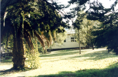
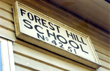
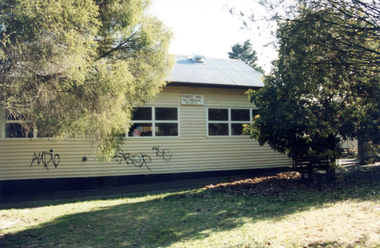
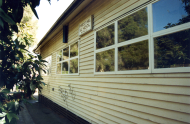
 Whitehorse Historical Society Inc.
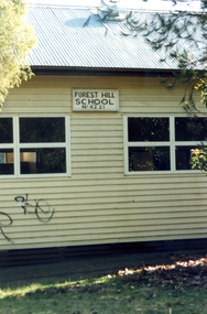
Photograph, Forest Hill State School, 1/08/1993 12:00:00 AM
... Forest Hill State School...forest hill state school. no. 4251...Coloured Photo of Forest Hill State School No. 4251.Springvale Road, Forest Hill. ...Whitehorse Historical Society Inc. 2-10 Deep Creek Road Mitcham melbourne School closed , demolished and land sold for housing . forest hill state school. no. 4251 Coloured Photo of Forest Hill State School No. 4251.Springvale Road, Forest Hill. ...School closed , demolished and land sold for housing .Coloured Photo of Forest Hill State School No. 4251.Springvale Road, Forest Hill. Since demolished. Part of a group of 24.forest hill state school. no. 4251 -
 Whitehorse Historical Society Inc.
Photograph, Forest Hill State School, 1/08/1993 12:00:00 AM
... Forest Hill State School...forest hill state school.no. 4251...Coloured Photo of Forest Hill State School No. 4251.Springvale Road, Forest Hill. ...Whitehorse Historical Society Inc. 2-10 Deep Creek Road Mitcham melbourne School closed , demolished and land sold for housing . forest hill state school.no. 4251 Coloured Photo of Forest Hill State School No. 4251.Springvale Road, Forest Hill. ...School closed , demolished and land sold for housing .Coloured Photo of Forest Hill State School No. 4251.Springvale Road, Forest Hill. Since demolished. Part of a group of 24.forest hill state school.no. 4251 -
 Whitehorse Historical Society Inc.
Photograph, Forest Hill State School, 1/08/1993 12:00:00 AM
... Forest Hill State School...forest hill state school. no. 4251...Coloured Photo of Forest Hill State School No. 4251.Springvale Road, Forest Hill. ...Whitehorse Historical Society Inc. 2-10 Deep Creek Road Mitcham melbourne School closed , demolished and land sold for housing . forest hill state school. no. 4251 Coloured Photo of Forest Hill State School No. 4251.Springvale Road, Forest Hill. ...School closed , demolished and land sold for housing .Coloured Photo of Forest Hill State School No. 4251.Springvale Road, Forest Hill. Since demolished. Part of a group of 24.forest hill state school. no. 4251