Showing 1183 items matching "state parks"
-
 Bendigo Historical Society Inc.
Document - STRAUCH COLLECTION: KAMAROOKA/WHIPSTICK AREA
... Kamarooka-Whipstick-State Parks...Envelope containing information & maps on Kamarooka area, includes Kamarooka & Whipstick State Parks, Elmore, Huntly....History House 11 Mackenzie Street Bendigo goldfields BHS Collection PLACE Land kamarooka Kamarooka-Whipstick-State Parks Envelope containing information & maps on Kamarooka area, includes Kamarooka & Whipstick State Parks, Elmore, Huntly. ...BHS CollectionEnvelope containing information & maps on Kamarooka area, includes Kamarooka & Whipstick State Parks, Elmore, Huntly.place, land, kamarooka, kamarooka-whipstick-state parks -
 Whitehorse Historical Society Inc.
Article, State park for our border, 2006
... State park for our border......State Parks...City of Whitehorse to have a state-controlled park at its border under a plan for Mullum Mullum Valley....State park for our border Article Article ...City of Whitehorse to have a state-controlled park at its border under a plan for Mullum Mullum Valley.City of Whitehorse to have a state-controlled park at its border under a plan for Mullum Mullum Valley.City of Whitehorse to have a state-controlled park at its border under a plan for Mullum Mullum Valley.city of whitehorse, state parks, mcinnes, ken, falkingham, cecily, friends of mullum mullum valley -
 Ringwood and District Historical Society
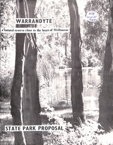
Book, Warrandyte - A Natural Reserve Close To The Heart Of Melbourne, 1969
... Warrandyte State Park proposal 1969...Ringwood and District Historical Society 125A Warrandyte Road Ringwood North melbourne Warrandyte State Park proposal 1969 Warrandyte - A Natural Reserve Close To The Heart Of Melbourne Book ...Warrandyte State Park proposal 1969 -
 Bendigo Historical Society Inc.
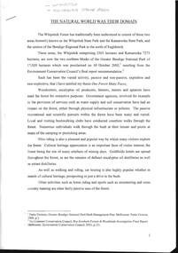
Document - THE NATURAL WORLD WAS THEIR DOMAIN
... Document, The Natural World was Their Domain, article about the Whipstick and Kamarooka State Park....DOCUMENT Whipstick Document, The Natural World was Their Domain, article about the Whipstick and Kamarooka State Park. Document THE NATURAL WORLD WAS THEIR DOMAIN ...Document, The Natural World was Their Domain, article about the Whipstick and Kamarooka State Park.document, whipstick -
 Pyrenees Shire Council
painting, Ken Burke, Mt Cole by Ken Burke, 2001
... watercolour painting of a bush track with two trees (Jimmy Smith Track, Mt Buangor State Park)...Pyrenees Shire Council 5 Lawrence Street Beaufort grampians significant as a work of art by local Pyrenees artist, locally significant to the Central Highlands Region of Victoria as a representation of local landscape and/or culture "signed: KEN BURKE (lower right) MT COLE (lower left)" watercolour painting of a bush track with two trees (Jimmy Smith Track, Mt Buangor State Park) Mt Cole by Ken Burke painting Ken Burke ...significant as a work of art by local Pyrenees artist, locally significant to the Central Highlands Region of Victoria as a representation of local landscape and/or culture watercolour painting of a bush track with two trees (Jimmy Smith Track, Mt Buangor State Park)"signed: KEN BURKE (lower right) MT COLE (lower left)" -
 Sunshine and District Historical Society Incorporated
Photograph - Deer Park State School Photographs
... Deer Park State School Photographs...Deer Park State School...This was soon shortened to Kororoit State School The Kororoit State School and was renamed to the Deer Park State School in 1890 when the local area's name was changed from Kororoit Creek to Deer Park. ...5343.01 - Deer Park State School Photo 01.jpg 5343.02 - Deer Park State School Photo 02.jpg 5343.03 - Deer Park State School 1942 Fire Photo 03.jpg 5343.04 - Deer Park State School 1942 Fire Photo 04.jpg 5343.05 - Deer Park State School 1942 Fire Photo 05.jpg 5343.06 - Deer Park State School 1942 Fire Photo 06.jpg 5343.07 - Deer Park State School Photo 07.jpg 5343.08 - Deer Park State School Photo 08.jpg 5343.09 - Deer Park State School Photo 09.jpg 5343.10 - Deer Park State School Photo 10.jpg 5343.11 - Deer Park State School Photo 11.jpg 5343.12 - Deer Park State School Photo 12.jpg 5343.13 - Deer Park State School Photo 13.jpg 5343.14 - Deer Park State School Photo 14.jpg 5343.15 - Deer Park State School Photo 15.jpg 5343.16 - Deer Park State School Photo 16.jpg...These photographs capture the original blue stone school building, the damaged caused by the 1942 fire and the 1943–44 replacement red‑brick main building. Deer Park State School Ballarat Road Deer Park Hume and Hovell Cairn 5343.01 - Deer Park State School Photo 01.jpg 5343.02 - Deer Park State School Photo 02.jpg 5343.03 - Deer Park State School 1942 Fire Photo 03.jpg 5343.04 - Deer Park State School 1942 Fire Photo 04.jpg 5343.05 - Deer Park State School 1942 Fire Photo 05.jpg 5343.06 - Deer Park State School 1942 Fire Photo 06.jpg 5343.07 - Deer Park State School Photo 07.jpg 5343.08 - Deer Park State School Photo 08.jpg 5343.09 - Deer Park State School Photo 09.jpg 5343.10 - Deer Park State School Photo 10.jpg 5343.11 - Deer Park State School Photo 11.jpg 5343.12 - Deer Park State School Photo 12.jpg 5343.13 - Deer Park State School Photo 13.jpg 5343.14 - Deer Park State School Photo 14.jpg 5343.15 - Deer Park State School Photo 15.jpg 5343.16 - Deer Park State School Photo 16.jpg Collection of digital black & white photograph Photograph Deer Park State School Photographs ...Deer Park State School began in 1874 as State School 1434 Braybrook but soon the school became known as the Derrimut on Kororoit Creek State School. This was soon shortened to Kororoit State School The Kororoit State School and was renamed to the Deer Park State School in 1890 when the local area's name was changed from Kororoit Creek to Deer Park. The school suffered several dramatic events due to its proximity to the ICI explosives factory. These events included the windows being blown out after lightning struck the ICI factory, the ceiling collapsed after an explosion at the ICI factory, and a fire destroyed the school in 1942. The 1940's rebuild of the school included a new red brick building with bluestone detailed used from the original building. The new building matched Percy Everett’s Education Department architectural style of the era. This school was relocated to Cairnlea in 2007 and became known as the Cairnlea Park Primary School. The old 1943–44 red‑brick main building (rebuilt after the 1942 fire), the blue stone remnants and the school grounds are now protected under Brimbank’s Heritage Overlay (HO84).These photographs capture the original blue stone school building, the damaged caused by the 1942 fire and the 1943–44 replacement red‑brick main building.5343.01 - Deer Park State School Photo 01.jpg 5343.02 - Deer Park State School Photo 02.jpg 5343.03 - Deer Park State School 1942 Fire Photo 03.jpg 5343.04 - Deer Park State School 1942 Fire Photo 04.jpg 5343.05 - Deer Park State School 1942 Fire Photo 05.jpg 5343.06 - Deer Park State School 1942 Fire Photo 06.jpg 5343.07 - Deer Park State School Photo 07.jpg 5343.08 - Deer Park State School Photo 08.jpg 5343.09 - Deer Park State School Photo 09.jpg 5343.10 - Deer Park State School Photo 10.jpg 5343.11 - Deer Park State School Photo 11.jpg 5343.12 - Deer Park State School Photo 12.jpg 5343.13 - Deer Park State School Photo 13.jpg 5343.14 - Deer Park State School Photo 14.jpg 5343.15 - Deer Park State School Photo 15.jpg 5343.16 - Deer Park State School Photo 16.jpgdeer park state school, ballarat road, deer park, hume and hovell cairn -
Lakes Entrance Historical Society
Book, Le Cheminant, Marion, Nyerimilang, 1999
... A short history of the Victorian State Park, Nyerimilang, on the Gippsland Lakes, from selection of the land to acquisition by Parks Victoria and formation of Friends of Nyerimilang....Lakes Entrance Historical Society 4 Marine Parade Lakes Entrance gippsland Parks Settlers Waterways A short history of the Victorian State Park, Nyerimilang, on the Gippsland Lakes, from selection of the land to acquisition by Parks Victoria and formation of Friends of Nyerimilang. ...A short history of the Victorian State Park, Nyerimilang, on the Gippsland Lakes, from selection of the land to acquisition by Parks Victoria and formation of Friends of Nyerimilang.parks, settlers, waterways -
 Bendigo Historical Society Inc.
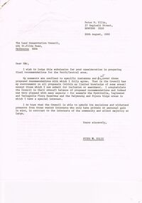
Document - PETER ELLIS COLLECTION: LETTER, 20th August, 1980
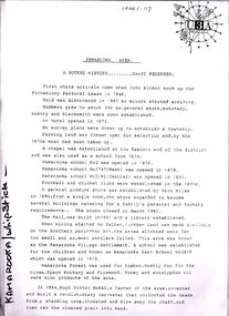
... ... Kamarooka State park...Letter refers to proposed State parks - Kamarooka State Park and Whipstick State Park. ...Letter refers to proposed State parks - Kamarooka State Park and Whipstick State Park. other areas mentioned are the Wellsford Forest, Mandurang Forest, Lockwood Forest, Waanyaraa, Fryerstown, Whipstick Hill (Flagstaff Hill) and Black Rock. ...Letter (11 Pages) from Peter N Ellis to the Land Conservation Council. Letter refers to proposed State parks - Kamarooka State Park and Whipstick State Park. other areas mentioned are the Wellsford Forest, Mandurang Forest, Lockwood Forest, Waanyaraa, Fryerstown, Whipstick Hill (Flagstaff Hill) and Black Rock. Other areas are Wellsford/Axedale Forest, Sugarloaf Range, Mandurang Forest, Main Coliban Channel, Lockwood Forest, Tarnagulla/Dunolly Forest, Fryerstown, Seven Sisters (between Huntly and Goornong). Plant and tree life in each area is mentioned including the cutting of eucalypt for the production of Eucalyptus oil.person, individual, peter ellis oam, peter ellis collection, land conservation council, kamarooka state park, whipstick state park, eucalyptus oil production, fncv victorian naturalist, d j paton, bendigo field naturalists club, wellsford forest, mandurang forest, main coliban channel, lockwood forest, waanyaras, fryerstown, whipstick hill (flagstaff hill), parish of neilborough, old underground water race, puddling machine, srwsc -
Marysville & District Historical Society
THE TRIANGLE NEWS-VOL 38 NO 36-OCTOBER 7 2011
... cathedral ranges state park...Marysville & District Historical Society 39 Darwin Street Marysville yarra-valley-and-the-dandenong-ranges marysville victoria australia triangle trails approved by council mayor peter beales dse murrindindi shire council colourful lining to marysville streets 308 trees to be planted across town council's bushfire reconstruction and recovery unit parks victorian ranges vandalism to recent facilities sugarloaf saddle cathedral ranges state park parks victoria advertisements yea country market THE TRIANGLE NEWS-VOL 38 NO 36-OCTOBER 7 2011 ...marysville, victoria, australia, triangle trails approved by council, mayor peter beales, dse, murrindindi shire council, colourful lining to marysville streets, 308 trees to be planted across town, council's bushfire reconstruction and recovery unit, parks victorian ranges, vandalism to recent facilities, sugarloaf saddle, cathedral ranges state park, parks victoria, advertisements, yea country market -
 Sunshine and District Historical Society Incorporated
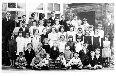
Photograph - Deer Park State School 1932 Photograph, 1932
... Deer Park State School 1932 Photograph...Deer Park State School...Deer Park State School 1434 in 1932...Deer Park State School 1434 in 1932|L to R Rear Mr Keith Shea Ron Brown Alan Thomas Lindsay OBrien Wally OBrien Clarrie Foley Frank Thomas|L to R 2nd Row Allan Govett Charles Tebbs Dave Ure Ted Newman Wallace Hunter Norm Thomas Albert Wilson Lyle Richardson Mr McKernan|L to R 3rd Row Jean Wilson Kitty Salmond Mary OBrien Alma Hunter Ruth Moseley Ella McLeod Jean Foley Jean Vincent Dorothy Sassella Ivy Foley Joyce Beaver Jean Moseley|L to R kneeling or sitting William Barry Jock Fisher Mabel Barry George Wilson Gina Thomas Joyce OBrien Mary Richardson Alex Salmond Bob Foley Ron Brown Keith Brown Tony Sassella Ken Brown Alex OBrien Lester Moseley Maurie Hunter...Deer Park State School State School Ballarat Road Deer Park Class Photograph Deer Park State School 1434 in 1932|L to R Rear Mr Keith Shea Ron Brown Alan Thomas Lindsay OBrien Wally OBrien Clarrie Foley Frank Thomas|L to R 2nd Row Allan Govett Charles Tebbs Dave Ure Ted Newman Wallace Hunter Norm Thomas Albert Wilson Lyle Richardson Mr McKernan|L to R 3rd Row Jean Wilson Kitty Salmond Mary OBrien Alma Hunter Ruth Moseley Ella McLeod Jean Foley Jean Vincent Dorothy Sassella Ivy Foley Joyce Beaver Jean Moseley|L to R kneeling or sitting William Barry Jock Fisher Mabel Barry George Wilson Gina Thomas Joyce OBrien Mary Richardson Alex Salmond Bob Foley Ron Brown Keith Brown Tony Sassella Ken Brown Alex OBrien Lester Moseley Maurie Hunter Deer Park State School 1434 in 1932 Photograph Deer Park State School 1932 Photograph ...Deer Park State School 1434 in 1932|L to R Rear Mr Keith Shea Ron Brown Alan Thomas Lindsay OBrien Wally OBrien Clarrie Foley Frank Thomas|L to R 2nd Row Allan Govett Charles Tebbs Dave Ure Ted Newman Wallace Hunter Norm Thomas Albert Wilson Lyle Richardson Mr McKernan|L to R 3rd Row Jean Wilson Kitty Salmond Mary OBrien Alma Hunter Ruth Moseley Ella McLeod Jean Foley Jean Vincent Dorothy Sassella Ivy Foley Joyce Beaver Jean Moseley|L to R kneeling or sitting William Barry Jock Fisher Mabel Barry George Wilson Gina Thomas Joyce OBrien Mary Richardson Alex Salmond Bob Foley Ron Brown Keith Brown Tony Sassella Ken Brown Alex OBrien Lester Moseley Maurie Hunterdeer park state school, state school, ballarat road, deer park, class photograph -
 Ballan Shire Historical Society
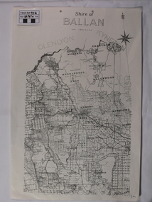
Map - Map. Shire of Ballan, Shire of Ballan
... A black and white map of the Shire of Ballan showing major roads, rivers, towns, settlements, State parks and forests and land subdivisions. ...Ballan Shire Historical Society 45-47 Steiglitz St Ballan goldfields This is a fairly comprehensive map of the former Shire of Ballan which is now amalgamated into the Shire of Moorabool. gordon ballan bungal kerrit bareet borhoneyghurk bungeeltap ballark yaloak gorong beremboke wallace ingliston hunterston millbrook bradshaw myrniong blackwood moorarbool greendale bayup trentham bullarto korweinguboora glenlyon bolwarra A black and white map of the Shire of Ballan showing major roads, rivers, towns, settlements, State parks and forests and land subdivisions. ...This is a fairly comprehensive map of the former Shire of Ballan which is now amalgamated into the Shire of Moorabool.A black and white map of the Shire of Ballan showing major roads, rivers, towns, settlements, State parks and forests and land subdivisions. It appears to be a copy of the original as no dates or maker or printer appear on the map. There is a scale of 2 miles to 1 inch.gordon, ballan, bungal, kerrit bareet, borhoneyghurk, bungeeltap, ballark, yaloak, gorong, beremboke, wallace, ingliston, hunterston, millbrook, bradshaw, myrniong, blackwood, moorarbool, greendale, bayup, trentham, bullarto, korweinguboora, glenlyon, bolwarra -
Whitehorse Historical Society Inc.
Document, Antonio Park State School No 4844, 1969
... Antonio Park State School No 4844...Antonio Park State School...A brief history of Antonio Park State School....A brief history of Antonio Park State School. Antonio Park State School No 4844 Document Document ...A brief history of Antonio Park State School.A brief history of Antonio Park State School.A brief history of Antonio Park State School.antonio park state school, history -
 Sunshine and District Historical Society Incorporated
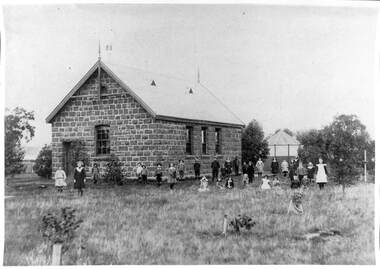
Photograph - Deer Park State School Bluestone Building Photograph, 1900
... Deer Park State School Bluestone Building Photograph...Deer Park State School...Photograph of Deer Park State School and 32 pupils standing in front of the bluestone building with bushes. ...Deer Park State School State School Deer Park Student Building Photograph of Deer Park State School and 32 pupils standing in front of the bluestone building with bushes. ...deer park state school, state school, deer park, student, building -
 Sunshine and District Historical Society Incorporated
Photograph - Deer Park State School Bluestone Building Photograph, 1900
... Deer Park State School Bluestone Building Photograph...Deer Park State School...Photograph of Deer Park State School and 32 pupils standing in front of the bluestone building with bushes. ...Deer Park State School State School Ballarat Road Deer Park Photograph of Deer Park State School and 32 pupils standing in front of the bluestone building with bushes. ...deer park state school, state school, ballarat road, deer park -
 Bacchus Marsh & District Historical Society
Map, Rough plan showing proposed deviation of road through McKenzie's Flat
... McKenzie's Flat is a bushland picnic area on the Lerderderg River in the Lerderderg State Park close to Bacchus Marsh. ...McKenzie's Flat is a bushland picnic area on the Lerderderg River in the Lerderderg State Park close to Bacchus Marsh. McKenzies Flat Bacchus Marsh Bacchus Marsh Roads and Streets Single page map showing a proposed deviation of the road near the McKenzie's Flat area close to Bacchus Marsh. ...The date of this map or plan is uncertain. McKenzie's Flat is a bushland picnic area on the Lerderderg River in the Lerderderg State Park close to Bacchus Marsh. Single page map showing a proposed deviation of the road near the McKenzie's Flat area close to Bacchus Marsh. The proposed deviation is shaded in pink, The existing road section to be replaced is shaded in blue. No scale is indicated. Part of a set of maps which are pasted into a bound volume containing 76 maps or plans in total. High resolution digital image stored on BMDHS computer network. mckenzies flat bacchus marsh, bacchus marsh roads and streets -
 Sunshine and District Historical Society Incorporated
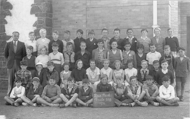
Photograph - Deer Park State School 1954 Class Photographs
... Deer Park State School 1954 Class Photographs...Deer Park State School...Digital Photograph Deer Park State School 1954 Grade 4B...Brimbank Library, 301 Hampshire Road, Sunshine 3020. melbourne Deer Park State School Ballarat Road Deer park Deer Park Grade IVB 1954 Digital Photograph Deer Park State School 1954 Grade 4B Photograph Deer Park State School 1954 Class Photographs ...Deer Park Grade IVB 1954deer park state school, ballarat road, deer park -
 Bayside Gallery - Bayside City Council Art & Heritage Collection
Photograph, Mark Radford, Mount Arapiles, Western Victoria, 2009
... Mount Arapiles-Tooan State Park...Mount Arapiles, or ‘Djurite’ is part of the Mount Arapiles-Tooan State Park approximately 30km west of Horsham. ...Mount Arapiles Djurite Mount Arapiles-Tooan State Park Horsham Horsham Rural City Council Mark Radford Wimmera Mountain Mount Arapiles, Western Victoria Photograph photograph Mark Radford ...Mount Arapiles, or ‘Djurite’ is part of the Mount Arapiles-Tooan State Park approximately 30km west of Horsham. Mark Radford was a former Mayor of Horsham Rural City Council and councillor for 12 years.Mark Radford, Mount Arapiles, Western Victoria 2009, photograph, 36 x 59.7 cm. Bayside City Council Art and Heritage Collection. Gift of Horsham Rural City Council, 2009.mount arapiles, djurite, mount arapiles-tooan state park, horsham, horsham rural city council, mark radford, wimmera, mountain -
 Sunshine and District Historical Society Incorporated
Photograph - Deer Park School Students 1929 Photograph, 1929
... Deer Park State School...Class photo of Deer Park State School students printed as a postcard. ...He worked for I.C.I Nobel factory for 45 1/2 years and left in 1980. Deer Park State School State School Deer Park Student Building Class photo of Deer Park State School students printed as a postcard. ...The Deer Park school photos were donated by Mr Jack Barry, who lived in Deer Park from 1921-1929 in Tilburn Rd. He worked for I.C.I Nobel factory for 45 1/2 years and left in 1980.deer park state school, state school, deer park, student, building -
 Ringwood and District Historical Society
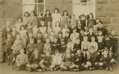
Photograph, Warrandyte Historical Society Newsletters nos. 68-75
... Noteable articles:- Warrandyte Primary School Artists (Clara Southern, Jo Sweatman) Potter's Cottage Architects Frank Crozier (artist) Warrandyte State Park Harris Gully Road Warrandyte Royal Women's Hospital Auxiliary Warrandyte Trade Directories 1899-1908 Gold nuggets in Warrandyte Gold mining in Warrandyte 1859-60 ...Ringwood and District Historical Society 125A Warrandyte Road Ringwood North melbourne Noteable articles:- Warrandyte Primary School Artists (Clara Southern, Jo Sweatman) Potter's Cottage Architects Frank Crozier (artist) Warrandyte State Park Harris Gully Road Warrandyte Royal Women's Hospital Auxiliary Warrandyte Trade Directories 1899-1908 Gold nuggets in Warrandyte Gold mining in Warrandyte 1859-60 Digitised WHS newsletters from August 1989 (no. 68) to October 1990 (no. 75). ...Digitised WHS newsletters from August 1989 (no. 68) to October 1990 (no. 75). Sent to Secretary of the Ringwood Historical Research Group, Jack Lindsay.Noteable articles:- Warrandyte Primary School Artists (Clara Southern, Jo Sweatman) Potter's Cottage Architects Frank Crozier (artist) Warrandyte State Park Harris Gully Road Warrandyte Royal Women's Hospital Auxiliary Warrandyte Trade Directories 1899-1908 Gold nuggets in Warrandyte Gold mining in Warrandyte 1859-60 -
 Eltham District Historical Society Inc
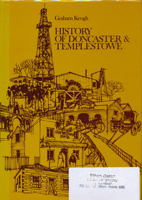
Book, City of Doncaster and Templestowe, History of Doncaster & Templestowe by Graham Keogh, 1975
... History of the City of Doncaster and Templestowe, beginning with first settlers on Bulleen and Templestowe rivers, including gold seekers, general development 1900-1945, expansion, road problem, disaster of 1962, traffic problems, Warrandyte State Park, historical research. photos index...Eltham District Historical Society Inc 728 Main Rd Eltham melbourne History of the City of Doncaster and Templestowe, beginning with first settlers on Bulleen and Templestowe rivers, including gold seekers, general development 1900-1945, expansion, road problem, disaster of 1962, traffic problems, Warrandyte State Park, historical research. photos index doncaster templestowe bulleen warrandyte ISBN 0959948716 466 p. ...History of the City of Doncaster and Templestowe, beginning with first settlers on Bulleen and Templestowe rivers, including gold seekers, general development 1900-1945, expansion, road problem, disaster of 1962, traffic problems, Warrandyte State Park, historical research. photos index466 p.ISBN 0959948716doncaster, templestowe, bulleen, warrandyte -
 Eltham District Historical Society Inc
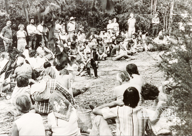
Photograph, Rally near the Koornung by the Warrandyte Environment League, c.1979, 1979c
... ...warrandyte state park...Accompanying note with photo: "7/12/94 celebrating 22 years of understanding and partnership for the environment between the Shire of Eltham and Warrandyte Environment League. 1979 saw a great victory in North Warrandyte with the Hamer Government buying 'The Koornung' on the Yarra for addition to the Warrandyte State park. This photo is of one of the rallies organised near the property by the League. ...Best wishes to staff, Doug Seymour for WEL" koornong warrandyte environment league warrandyte state park Black and white photograph Rally near the Koornung by the Warrandyte Environment League, c.1979 Photograph ...Accompanying note with photo: "7/12/94 celebrating 22 years of understanding and partnership for the environment between the Shire of Eltham and Warrandyte Environment League. 1979 saw a great victory in North Warrandyte with the Hamer Government buying 'The Koornung' on the Yarra for addition to the Warrandyte State park. This photo is of one of the rallies organised near the property by the League. Best wishes to staff, Doug Seymour for WEL"Black and white photographkoornong, warrandyte environment league, warrandyte state park -
 Sunbury Family History and Heritage Society Inc.
Photograph, Gellibrand Hill, c1989
... The emphasis on the day's excursion was to identify the native fauna in the park as well as the vegetation.The property was originally settled by the Greene family in 1843. In 1980 the State Government purchased the property and it is now one of the state's parks where the natural vegetation has gradually been restored on the property. ...The emphasis on the day's excursion was to identify the native fauna in the park as well as the vegetation.The property was originally settled by the Greene family in 1843. In 1980 the State Government purchased the property and it is now one of the state's parks where the natural vegetation has gradually been restored on the property. ...The children from Bulla Primary School were taken on an excursion to Gellibrand Hill Park which is a short distance from the School. The emphasis on the day's excursion was to identify the native fauna in the park as well as the vegetation.The property was originally settled by the Greene family in 1843. In 1980 the State Government purchased the property and it is now one of the state's parks where the natural vegetation has gradually been restored on the property. A non-digital coloured photograph with a cream border, of a group of adults and children listening to a man who is standing in front of a low seat and talking to them. There are buildings visible in the background. gellibrand hill, bulla primary school, school excursions -
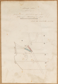
![Map, Plan showing proposed deviation of the road through McKenzie's Flat to Bacchus Marsh. [Undated]](/media/collectors/5e461d8021ea67224c82f2a1/items/677d22f37f2053f3e5d500dc/item-media/677d25247f2053f3e5d50950/item-fit-380x285.jpg?cb=6) Bacchus Marsh & District Historical Society
Bacchus Marsh & District Historical SocietyMap, Plan showing proposed deviation of the road through McKenzie's Flat to Bacchus Marsh. [Undated]
... McKenzie's Flat is a bushland picnic area on the Lerderderg River in the Lerderderg State Park close to Bacchus Marsh. The proposed road deviation shown on this map is very close to a sharp bend in the Lerderderg River which shows an island in the centre of that bend. ...McKenzie's Flat is a bushland picnic area on the Lerderderg River in the Lerderderg State Park close to Bacchus Marsh. The proposed road deviation shown on this map is very close to a sharp bend in the Lerderderg River which shows an island in the centre of that bend. ...The date of this map or plan is uncertain. McKenzie's Flat is a bushland picnic area on the Lerderderg River in the Lerderderg State Park close to Bacchus Marsh. The proposed road deviation shown on this map is very close to a sharp bend in the Lerderderg River which shows an island in the centre of that bend. The name of a landholder, J.B. Perry is shown on the map close to the area of the road deviation.The land shown is identified as within the Parish of Merrimu.Single page map showing a proposed deviation of the road from McKenzie's Flat to Bacchus Marsh. Scale: 5 chains to 1 inch. Part of a set of maps which are pasted into a bound volume containing 76 maps or plans in total. High resolution digital image stored on BMDHS computer network. mckenzies flat bacchus marsh, bacchus marsh roads and streets -
 Warrnambool and District Historical Society Inc.
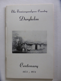
Booklet, The Temiangandeen Country Dergholm, 1973
... Dergholm is in the far west of Victoria 334 kilometres from Melbourne and nearby is Dergholm State Park established in 1982. The booklet was produced for the Centenary Back to Dergholm Committee and the local centenary celebrations. ...Dergholm is in the far west of Victoria 334 kilometres from Melbourne and nearby is Dergholm State Park established in 1982. The booklet was produced for the Centenary Back to Dergholm Committee and the local centenary celebrations. ...This booklet gives information on the settlement of Dergholm at the time of the centenary of its founding, 1973. The origin of the name Dergholm is unclear but it may have Irish connections. Europeans came to the area in the 1840s and 50s but it was not until the 1870s that the town was surveyed. Dergholm is in the far west of Victoria 334 kilometres from Melbourne and nearby is Dergholm State Park established in 1982. The booklet was produced for the Centenary Back to Dergholm Committee and the local centenary celebrations. This book is of some interest as it provides information on Dergholm, a settlement in the far west of Western Victoria. This is a soft cover booklet of 52 pages by Alistair Roper. It has a cream-coloured cover with a black and white photograph of early Dergholm on the front cover (Edward Quinn’s house). The booklet has printed material - a President’s Message, an Author’s Note, Acknowledgements, Contents, information on the Dergholm area, including a list of local birds, and References. There are several black and white photographs of the area and its people. The book is stapled. Front Cover: ‘The Temiangandgeen Country, Dergholm Centenary, 1873-1973’dergholm victoria, alistair roper, history of western district of victoria -
 Wonga Park Community Cottage History Group
Photograph - 1930s Empire Day, at Wonga Park State School
... at Wonga Park State School...1930s Empire Day at Wonga Park State School...Wonga Park Community Cottage History Group Unit 1, 9 – 13 Old Yarra Road Wonga Park melbourne 1930s Empire Day at Wonga Park State School at Wonga Park State School Photograph 1930s Empire Day ...1930s Empire Day at Wonga Park State School -
![Map, [Coornmill land area available for leasing for grazing, Parish of Coornmill]. Circa 1904](/media/collectors/5e461d8021ea67224c82f2a1/items/677cde147f2053f3e5d277c3/item-media/677cdeea7f2053f3e5d27bb4/item-fit-380x285.jpg?cb=6) Bacchus Marsh & District Historical Society
Bacchus Marsh & District Historical SocietyMap, [Coornmill land area available for leasing for grazing, Parish of Coornmill]. Circa 1904
... ...Lerderderg State Park Maps...This map shows an area of land north of Bacchus Marsh in the Larderderg State Park area known as the Parish of Coornmill.The map indicates an area of land which was to be made available by public tender for grazing leaseholders. ...Coornmill Parish Maps Lerderderg State Park Maps Agriculture Bacchus Marsh Area A single page paper map showing an area of land in the Parish of Corrnmill to be made available for grazing leases. ...This map shows an area of land north of Bacchus Marsh in the Larderderg State Park area known as the Parish of Coornmill.The map indicates an area of land which was to be made available by public tender for grazing leaseholders. The plan to do this was discussed in the Bacchus Marsh Express newspaper on the 16 July, 1904, page 2, column 7. The area reserved for grazing leases is identified by red lines on the map. The Express described the area available for grazing was 12,000 acres.A single page paper map showing an area of land in the Parish of Corrnmill to be made available for grazing leases. A photo lithographed Lands Department Map. No scale indicated. The map is pasted into a bound volume containing 76 maps or plans in total. High resolution digital image stored on BMDHS computer network. coornmill parish maps, lerderderg state park maps, agriculture bacchus marsh area -
 Chelsea & District Historical Society Inc
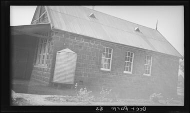
Photograph - Chelsea State School, Front view of the school, 1960
... Black and white photo of the front of Chelsea State School. Two cars parked on street in front of school....Chelsea Education Chelsea Primary School school Chelsea State School School playground garden opening Black and white photo of the front of Chelsea State School. Two cars parked on street in front of school. ...Chelsea State School was built on Argyle Avenue and officially opened on 27 January 1915.Black and white photo of the front of Chelsea State School. Two cars parked on street in front of school.chelsea, education, chelsea primary school, school, chelsea state school, school playground, garden, opening -
 Warrnambool and District Historical Society Inc.
33.3 R.P.M. Record (Warrnambool Technical School), H.M.S. Pinafore, 1971
... This business used a local landmark, the Tower Hill State Park, as its logo and label. The recording is of the 1971 production of ‘H.M.S. ...This business used a local landmark, the Tower Hill State Park, as its logo and label. The recording is of the 1971 production of ‘H.M.S. ...This record was made by a local business existing in the 1960s and early 70s, Warrnambool Recording Enterprises. This business used a local landmark, the Tower Hill State Park, as its logo and label. The recording is of the 1971 production of ‘H.M.S. Pinafore’ by the students of Warrnambool Technical College. This school was established in 1913 in Timor Street and in 1973, as Warrnambool Technical School, was relocated to Caramut Road and re-named Brauer college in 1990. The Timor Street site is now the South West TAFE College. This record is of interest as a memento both of the Warrnambool Technical College’s musical performance in 1971 and of the production of records such as this one by a local business, Warrnambool Recording Enterprises in the early 1970s. This is a 33.3 R.P.M. record with a part-image of a guitar and a yellow label in the centre with black printing and typing. It is in a paper sleeve which is tattered with the bottom section mostly missing. The cover does not appear to belong to the record. Tower Hill HMS Pinafore presented by students of Warrnambool Technical School 1971 Custom Recording by Warrnambool Recording Enterprises P.O. Box 123 Warrnambool Phone 8223warrnambool technical school, warrnambool recording enterprises tower hill label, history of warrnambool, ‘h.m.s. pinafore’ -
 National Vietnam Veterans Museum (NVVM)
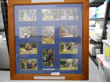
Photograph, Framed Collage, Mabel Park State High School Vietnam Memorial
... Framed Collage, Mabel Park State High School Vietnam Memorial......Mabel Park State High School...Framed Collage of coloured Photograph taken during the Dedication of the Vietnam Memorial on the schoold grounds at Mabel park State High School grounds on ANZAC Day 1998...National Vietnam Veterans Museum (NVVM) 25 Veterans Drive Newhaven phillip-island-and-the-bass-coast Photograph vietnam Memorial Mabel Park State High School Two lots of details of the Memorial and those involved Framed Collage of coloured Photograph taken during the Dedication of the Vietnam Memorial on the schoold grounds at Mabel park State High School grounds on ANZAC Day 1998 Framed Collage, Mabel Park State High School Vietnam Memorial Photograph Photograph ...Framed Collage of coloured Photograph taken during the Dedication of the Vietnam Memorial on the schoold grounds at Mabel park State High School grounds on ANZAC Day 1998Two lots of details of the Memorial and those involvedphotograph, vietnam memorial, mabel park state high school -
 Eltham District Historical Society Inc
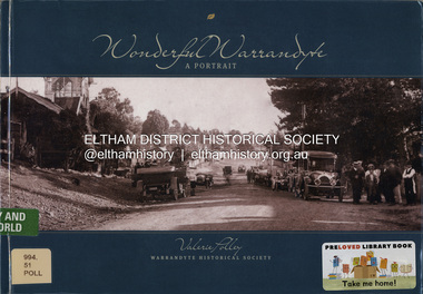
Book, Valerie Polley, Wonderful Warrandyte: A Portrait, 2014
... Its pre-European and early settlement history, its goldmining heritage, the effects of bushfires and floods, the Yarra River, the Warrandyte State Park, its buildings and historic precinct are all featured. ...Its pre-European and early settlement history, its goldmining heritage, the effects of bushfires and floods, the Yarra River, the Warrandyte State Park, its buildings and historic precinct are all featured. ...The township of Warrandyte, on the outer urban fringe of Melbourne, holds a significant place in Victoria's history as the first recorded goldfield in the State. Its pre-European and early settlement history, its goldmining heritage, the effects of bushfires and floods, the Yarra River, the Warrandyte State Park, its buildings and historic precinct are all featured. The artistic era with its many eminent artisans, architects, potters and painters is covered. Details of the historic buildings that still remain are included. This is an informative, beautifully illustrated book that will appeal to a wide audience.gold mining, warrandyte