Showing 240 items matching "station avenue"
-
 Greensborough Historical Society
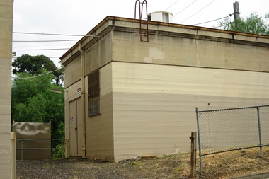
Photograph - Photograph - Digital Image, Marilyn Smith, Poulter Avenue power station - Greensborough Railway Station 2021, 2021_02
... Poulter Avenue power station - Greensborough Railway Station 2021...station...hurstbridge rail line upgrade...poulter avenue...Photographs of Poulter Avenue power station at Greensborough Railway Station in February 2021, before the planned rebuild of the station as part of the Hurstbridge rail line upgrade. ...Greensborough Historical Society 34A Glenauburn Road Lower Plenty Lower Plenty melbourne Photographs of Poulter Avenue power station at Greensborough Railway Station in February 2021, before the planned rebuild of the station as part of the Hurstbridge rail line upgrade. greensborough railway station hurstbridge rail line upgrade poulter avenue greensborough 4 Colour digital photographs Poulter Avenue power station - Greensborough Railway Station 2021 Photograph Photograph - Digital Image Marilyn Smith ...Photographs of Poulter Avenue power station at Greensborough Railway Station in February 2021, before the planned rebuild of the station as part of the Hurstbridge rail line upgrade. 4 Colour digital photographsgreensborough railway station, hurstbridge rail line upgrade, poulter avenue greensborough -
 Ringwood and District Historical Society
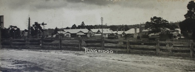
Photograph, View of buildings on Maroondah Highway, Ringwood, taken overlooking railway yard from Station Street and Greenwood Avenue - 1914
... View of buildings on Maroondah Highway, Ringwood, taken overlooking railway yard from Station Street and Greenwood Avenue - 1914....Enlarged copy of smaller archived photograph - view of buildings on Maroondah Hwy taken overlooking railway yard from Station Street and Greenwood Avenue, 1914. Black and white photo on heavy cardboard backing....View of buildings on Maroondah Highway, Ringwood, taken overlooking railway yard from Station Street and Greenwood Avenue - 1914. Photograph ...Enlarged copy of smaller archived photograph - view of buildings on Maroondah Hwy taken overlooking railway yard from Station Street and Greenwood Avenue, 1914. Black and white photo on heavy cardboard backing. -
 Greensborough Historical Society
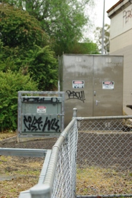
Photograph - Photograph - Digital Image, Marilyn Smith, Poulter Avenue power station, architectural features - Greensborough Railway Station 2021, 2021_02
... Poulter Avenue power station, architectural features - Greensborough Railway Station 2021...station...hurstbridge rail line upgrade...poulter avenue...Photographs of architectural features at Poulter Avenue power station at Greensborough Railway Station in February 2021, before the planned rebuild of the station as part of the Hurstbridge rail line upgrade. ...Greensborough Historical Society 34A Glenauburn Road Lower Plenty Lower Plenty melbourne Photographs of architectural features at Poulter Avenue power station at Greensborough Railway Station in February 2021, before the planned rebuild of the station as part of the Hurstbridge rail line upgrade. greensborough railway station hurstbridge rail line upgrade poulter avenue greensborough 5 Colour digital photographs Poulter Avenue power station, architectural features - Greensborough Railway Station 2021 Photograph Photograph - Digital Image Marilyn Smith ...Photographs of architectural features at Poulter Avenue power station at Greensborough Railway Station in February 2021, before the planned rebuild of the station as part of the Hurstbridge rail line upgrade. 5 Colour digital photographsgreensborough railway station, hurstbridge rail line upgrade, poulter avenue greensborough -
 Whitehorse Historical Society Inc.
Article, Railway Work Piles Up, 2016
... Station...Metropolitan Avenue...Over 1000 piles of up to 1 metre in diameter will be bored along the length of the 9m deep cutting, every 2.7 metres between Blackburn Railway Station and Metropolitan Avenue, Nunawading....Whitehorse Historical Society Inc. 2-10 Deep Creek Road Mitcham melbourne Blackburn Railway Crossing Blackburn Railway Station Metropolitan Avenue Nunawading Over 1000 piles of up to 1 metre in diameter will be bored along the length of the 9m deep cutting, every 2.7 metres between Blackburn Railway Station and Metropolitan Avenue, Nunawading. ...Over 1000 piles of up to 1 metre in diameter will be bored along the length of the 9m deep cutting, every 2.7 metres between Blackburn Railway Station and Metropolitan Avenue, Nunawading.Over 1000 piles of up to 1 metre in diameter will be bored along the length of the 9m deep cutting, every 2.7 metres between Blackburn Railway Station and Metropolitan Avenue, Nunawading.Over 1000 piles of up to 1 metre in diameter will be bored along the length of the 9m deep cutting, every 2.7 metres between Blackburn Railway Station and Metropolitan Avenue, Nunawading.blackburn railway crossing, blackburn railway station, metropolitan avenue, nunawading -
 Ringwood and District Historical Society
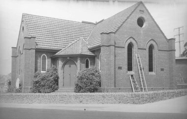
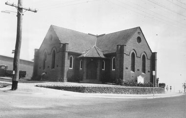
Photograph, Methodist Church, cnr Station Street and Greenwood Avenue, Ringwood. Start of demolition - 1963
... Methodist Church, cnr Station Street and Greenwood Avenue, Ringwood. Start of demolition - 1963....Black and white photograph (2 copies- 1 large, 1smaller) Methodist Church, cnr Station Street and Greenwood Avenue, Ringwood. Start of demolition - 1963. ...Black and white photograph (2 copies- 1 large, 1smaller)Written on rear of backing sheet of large copy: "Old Methodist church, Feb/Mar, 1963. 1st step in demolition. Removal of windows." -
 Ringwood and District Historical Society
Photograph, Methodist Church, cnr Station Street and Greenwood Avenue, Ringwood. Start of demolition - 1963
... Methodist Church, cnr Station Street and Greenwood Avenue, Ringwood. Start of demolition - 1963....Black and white photograph (2 copies- 1 large, 1 smaller) Methodist Church, cnr Station Street and Greenwood Avenue, Ringwood. Start of demolition - 1963. ...Black and white photograph (2 copies- 1 large, 1 smaller)Written on back of small photograph: "Rwd. Meth. on 1st day of demolishing,1963." -
 Sunshine and District Historical Society Incorporated
Photograph - St. Albans, John Alchin, Photographs 2024, 2024
... ...Station Avenue...Ivanhoe Parade St. Albans Station Avenue 5559.01 - Ivanhoe Ave 48 St. Albans - Former Shop 2024 Photo 01.jpg Digital photograph Photographs 2024 Photograph St. ...These photographs provide a visual record of assorted buildings, street views, and notable locations throughout St. Albans in 2024.This photograph collection documents St. Albans in 2024.5559.01 - Ivanhoe Ave 48 St. Albans - Former Shop 2024 Photo 01.jpgivanhoe parade, st. albans, station avenue -
Whitehorse Historical Society Inc.
Map, Burwood Road, Box Hill City, 15/02/1952 12:00:00 AM
... Between Milford Avenue and Station Street. Marked as Survey Plan No 5441....Plan of subdivision of ten blocks in Burwood Road, Burwood between Milford Avenue and Station Street. Marked as Survey Plan No 5441....Whitehorse Historical Society Inc. 2-10 Deep Creek Road Mitcham melbourne Between Milford Avenue and Station Street. Marked as Survey Plan No 5441. ...Plan of subdivision of ten blocks in Burwood Road, Burwood.Plan of subdivision of ten blocks in Burwood Road, Burwood between Milford Avenue and Station Street. Marked as Survey Plan No 5441.Plan of subdivision of ten blocks in Burwood Road, Burwood. land subdivision, burwood road, burwood, milford avenue, burwood, central court, burwood -
Glen Eira Historical Society
Document - GLEN HUNTLY (HISTORY OF)
... Avenue... Rosstown Court... Hostels... Murrumbeena... Cinemas... Innovations (Cabinetry Film)... Films... Music... Pianos... Manchester Grove... Safeway Store... Squash Courts... Airports... Lord Reserve... Aeroplanes... Air Navigation Act 1921... Neville Street... Larkin Sopwith Aviation Company of Australasia... Lyons Street... Morgan Street... Bookmakers... Nightsoil... Poultry... Weatherboard Buildings... Glen Huntly Railway Station...Waratah Avenue Royal Avenue Munster Avenue James Street Rothschild Street Peace Memorial Organ Singers Bremner Marie Scotland Betty Carden Joan Rosstown Railway South Caulfield Plants Marata Road Curraweena Road Bambra Road Ross William Murray Ross Leila Ross Constance Vautin Constance ‘The Grange’ North Road Leila Road Wild Cherry Road Caulfield Roads Board Elsternwick Land Sales Sugar Mills Koornang Road Woornack Road Elsternwick Railway Station Riddell Parade Clarence Street Dover Street Oakleigh Road Murrumbeena Crescent Carlisle Crescent Railways Trains Parks and Reserves Caulfield Council Sussex Street Caulfield City Council Swamps Rosstown Sugar Mill Rosstown Estate ‘The Swagman’s Retreat’ Arnott Herb Rosstown Carnegie ‘Ross’s Folly’ Carnegie Andrew Rosstown Hotel Dandenong Road Rosstown Road Rosstown Plate Horse Race Caulfield Racecourses Ames Avenue Rosstown Court Hostels Murrumbeena Cinemas Innovations (Cabinetry Film) Films Music Pianos Manchester Grove Safeway Store Squash Courts Airports Lord Reserve Aeroplanes Air Navigation Act 1921 Neville Street Larkin Sopwith Aviation Company of Australasia Lyons Street Morgan Street Bookmakers Nightsoil Poultry Weatherboard Buildings Glen Huntly Railway Station Rosedale Avenue Rifle Clubs Scout Groups 1st Glen Huntly Troop ANA Dowding Jack Mr. ...This file contains one item: 1/A loose-leaf, 23-page document titled ‘The History of Glen Huntly’, by Alfred R. Jones, dated 20/06/1991, describing the history of the suburb. The author has drawn heavily from the 4 sources noted in the bibliography. Subjects covered include the ship the suburb is named after, the suburb’s State School, the suburb’s churches, the Rosstown Railway and Sugar Mill, the origin of the name of Carnegie, the suburb’s aerodrome, and the beautification of the Glen Huntly Shopping Centre. The final 12 pages consist of 9 appendices relating to the aforementioned subjects. Appendix A is a typewritten letter from Ron McLeod, secretary of the Place Names Committee, to Mr. D. R. Aylen, CEO of the City of Caulfield, notifying the latter of the alteration of the name ‘Glenhuntly’ to ‘Glen Huntly’. Appendix B is a list of the ministers of St. David’s Uniting Church from its formation in 1916 to the present. Appendix C identifies the persons portrayed in St. David’s stained glass windows. Appendix D is a poster announcing the auction of 41 blocks of land between Hawthorn and Bambra Road formerly owned by William Ross, plus a map identifying said land blocks and another for locality. Appendix E is an A4 plan of the Rosstown Railway. Appendix F is a drawing of the Rosstown Sugar Mill. Appendix G is a poem titled ‘The Swagman’s Retreat’, by Herb Arnott, about the failure of the Mill. Appendix H is a map of Caulfield’s horse tramways plus a list of opening and closing dates. Appendix J is a list of streets explaining the meanings of their names.glen huntly, glenhuntly, local history, ‘glen huntly’ (ship), ‘glen huntlely’ (ship), quarantine stations, glen huntly road, lake street, mernda avenue, glen huntly state school no. 3703, ormond francis, ormond, garden avenue, grange road, churches, congregational church, glen huntly presbyterian church, st. david’s, st. david’s uniting church, anglican church, jenkin william ‘boss’, methodist church, wattle avenue, smith a. w. mr., glen huntly post office, glen huntly road, king f. l. mr., uniting church, child care centre, presbyterian church of eastern australia, glen huntly methodist church, sun aria, miller mary, stained glass, phrenologists, trinity congregational church, primitive methodists, ‘the victorian independent’, mercy mr., greek orthodox original old calendar church, wanalta road, salvation army, halls, myrtle street, catholic church, st. anthony’s roman catholic church, foundation stones, neerim road, mannix archbishop, st. agnes’ anglican church, booran road, sunday schools, clergy residences, ‘see’ anglican news magazine, lees archbishop, booth archbishop, glen huntly presbyterian church, el nido grove, tennis courts, bollard v. w. right rev., waratah avenue, royal avenue, munster avenue, james street, rothschild street, peace memorial organ, singers, bremner marie, scotland betty, carden joan, rosstown railway, south caulfield, plants, marata road, curraweena road, bambra road, ross william murray, ross leila, ross constance, vautin constance, ‘the grange’, north road, leila road, wild cherry road, caulfield roads board, elsternwick, land sales, sugar mills, koornang road, woornack road, elsternwick railway station, riddell parade, clarence street, dover street, oakleigh road, murrumbeena crescent, carlisle crescent, railways, trains, parks and reserves, caulfield council, sussex street, caulfield city council, swamps, rosstown sugar mill, rosstown estate, ‘the swagman’s retreat’, arnott herb, rosstown, carnegie, ‘ross’s folly’, carnegie andrew, rosstown hotel, dandenong road, rosstown road, rosstown plate horse race, caulfield racecourses, ames avenue, rosstown court, hostels, murrumbeena, cinemas, innovations (cabinetry film), films, music, pianos, manchester grove, safeway store, squash courts, airports, lord reserve, aeroplanes, air navigation act 1921, neville street, larkin sopwith aviation company of australasia, lyons street, morgan street, bookmakers, nightsoil, poultry, weatherboard buildings, glen huntly railway station, rosedale avenue, rifle clubs, scout groups, 1st glen huntly troop, ana, dowding jack mr., glen huntly infant welfare and family planning clinic, vermador private hospital, watson grove, rowlands (drapers), bones plant nursery, caulfield railway station, bridges, trams, horse tramways, glen eira road, elsternwick railway station, kooyong road, aboriginal peoples, truganini road, hannan lyn mrs. (urban planning officer), glen huntly shopping centre, sculptures, street beautification scheme, “flying the yellow flag”, moore olive, “return to rosstown”, jowett d. f., weickhardt i. s., “from sand swamp and health”, murray peter r., wells john c., caulfield historical society, newsletters, place names committee, mcleod ron, aylen d. r. mr., jones hugh rev., king joseph, scarfe james, vertigan sidney, vertigan earle, rance victor, flavell cameron, denholm robin, moorhead ken, taliai siupeli, eccles james leslie, little agnes, hutchins william r., dickie may a., gordon ivey agnes, theobald a. a. mrs., brownbill lloyd norman, ash georgette, land sales, auctions, messrs. crews & arkle, street names -
 Greensborough Historical Society
Photograph - Digital Image, Greensborough Station, early 1900s, 1910_
... station...poulter avenue greensborough...Greensborough Station pre-World War I. The orchard on the land in the foreground is now Poulter Avenue and Pope Place....Shows the rural nature of the Greensborough area in the early 20th century trains greensborough railway station poulter avenue greensborough pope place greensborough Digital copy of black and white photograph. ...Greensborough Station pre-World War I. The orchard on the land in the foreground is now Poulter Avenue and Pope Place.Shows the rural nature of the Greensborough area in the early 20th centuryDigital copy of black and white photograph. trains, greensborough railway station, poulter avenue greensborough, pope place greensborough -
Whitehorse Historical Society Inc.
Map, Tunstall 1945, 1945
... Station...Tunstall Avenue Nunawading...Whitehorse Historical Society Inc. 2-10 Deep Creek Road Mitcham melbourne Tunstall Tunstall Railway Station Tunstall Avenue Nunawading Tunstall State School No 4190 Fraser Colin A map drawn from memory about 20 years ago by Colin Fraser of the businesses and residents of Tunstall, 1945, including the location of Fraser General Store. ...A map drawn from memory about 20 years ago by Colin Fraser of the businesses and residents of Tunstall, 1945, including the location of Fraser General Store.A map drawn from memory about 20 years ago by Colin Fraser of the businesses and residents of Tunstall, 1945, including the location of Fraser General Store.A map drawn from memory about 20 years ago by Colin Fraser of the businesses and residents of Tunstall, 1945, including the location of Fraser General Store.tunstall, tunstall railway station, tunstall avenue nunawading, tunstall state school no 4190, fraser, colin -
 Whitehorse Historical Society Inc.
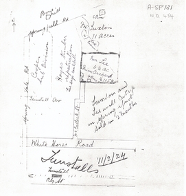
Document, 1924 Tunstall Properties, 11/02/1924 12:00:00 AM
... station...tunstall avenue...Whitehorse Historical Society Inc. 2-10 Deep Creek Road Mitcham melbourne plans whitehorse road nunawading tunstall railway station tunstall avenue springvale road springfield road luxton lee mcculloch street hayes timber cooper land subdivision Hand drawn plans of properties bordered by Tunstall (Nunawading) Railway Station, Hand drawn plans of properties bordered by Tunstall (Nunawading) Railway Station, Springvale Road and Springfield Road. 1924 Tunstall Properties Document Document ...Hand drawn plans of properties bordered by Tunstall (Nunawading) Railway Station,Hand drawn plans of properties bordered by Tunstall (Nunawading) Railway Station, Springvale Road and Springfield Road.Hand drawn plans of properties bordered by Tunstall (Nunawading) Railway Station, plans, whitehorse road, nunawading, tunstall railway station, tunstall avenue, springvale road, springfield road, luxton, lee, mcculloch street, hayes timber, cooper, land subdivision -
 Whitehorse Historical Society Inc.
Photograph, Electric Sub-station, Mitcham, 1998
... Coloured photograph of sub-station in Vernal Avenue, Mitcham. House behind....Whitehorse Historical Society Inc. 2-10 Deep Creek Road Mitcham melbourne electric sub-station electricity Coloured photograph of sub-station in Vernal Avenue, Mitcham. House behind. Electric Sub-station, Mitcham Photograph Photograph ...Coloured photograph of sub-station in Vernal Avenue, Mitcham. House behind.electric sub-station, electricity -
Glen Eira Historical Society
Document - LECHTE, WILLIAM LUDWIG SAMUEL SEBASTION
... Station... Alma Road... Dairies... Caulfield Park... Swamp... Queens Avenue...Grange Road Glenhuntly Glen Huntly Station Alma Road Dairies Caulfield Park Swamp Queens Avenue Station Street Cross Street Racecourse Heywood J. ...3 items about this person: 1/Two twelve page carbon copied documents, purportedly written by William Letchte, son of George, written in c1935/36. He writes of his jobs as a dairyman, cow minder at the age of ten tears. He recollects streets, people, residences, business and general landscape in the area, as he takes you on a tour of the area. 2/Photocopied photo of Katrina Lechte (nee Bolch?) donated by Ian Lechte, 15 Adrian Street, East Bentleigh. 3/Photocopied copy of first pages and cover of William Lechte’s booklet on ‘Caulfield 1869 – 1935 Memories of the Past’, published by the City of Caulfield, 1992. The Society has the full booklet in its book collection (not yet catalogued as of 07/07/2015).grange road, glenhuntly, glen huntly station, alma road, dairies, caulfield park, swamp, queens avenue, station street, cross street, racecourse, heywood j. g., turf club hotel, dandenong road, royal hotel, koornang road, north road, murrumbeena road, mclaurin archibald, crosbie j. w., poath road, newton mr., hooker mr., peck family robert farmer, dairies, ross murray, rosstown, hansen hans, arnott family, peppin family, ormond station, malane family, fraser simon, overtons, shepherds, spring road, mohlers, brighton cemetery, mall kim, market gardeners, long john farmer, fiedler mr., booran road, reservoir, summers mr., maddocks mr., holland mr., caulfield council, glen eira road, harriman benjamin c., kambrook road, bambra road, princess park, marriott john, hawthorn road, brickworks, hyam mr., cottages, jasmine street, sycamore street, paddy o’briens swamp, arnold tom, london tavern hotel, guess john-grocer, topp mr., poath road, pine trees, colonel le marehand, balaclava junction, chemist shop, bell mr., nicholls mr. william h., wine shop, orme mr., pepperorn mr. john, balaclava road, orchards, harvey mr. robert tailor, schubert mr., blew charlie – gardener, philpott mr. richard b., farquhar mr. william farmer, newing t. r., glen eira road, payne john, brockhoft mr., dickson mr. james, snipe t., bevan mr., mckean family john, murray family, francis mr., hart mr., mcdougall james, brady peter, cad, elsternwick station, webb mr., masters mr. samuel, master street, ford mr., anderson mr. joseph gardener, slaney mr., boxhill mr. richard, post office, newsagent, hotham street, service james, bunn mr., sargood mr., orrong road, arnold tom – dairy, officer mr., grimwade mr., alexandra street, oakleigh hall, degraves mr., wilson samuel, ‘manifold’, house names, miller septimus, alma road, knox mr. james gardener, smith mr., coachman, ‘cumloden’, lange mr., holyrood justice mr., cronin mrs. mary, mcgivenys dairy, ‘belle vista’, lloyd c. d., caulfield council, hughes mr., armstrong j. a., tom healey’s market garden, kooyong road, inkerman road, tom roe’s market garden, mcleod captain, daish captain, plumridger mr. frederick, gardeners, tester mr. thomas, kent mr., kent g., fiddes mr., billings mr., semple mr., fosberry mr., howitt or., merrett mr., orchards, hawthorn road, hines mr., ‘rosecraddock’, langdon h. j., ‘crotonhurst’, webb justice mr., renwick s., ‘garrell’, barry mr., drinsdale family, st. mary’s church, sunday school, newing miss, teachers, stephen justice mr., stephen wilberforce, mount l., grimwade’s, ‘grimwade house’, danby’s, spence mr., venables family, mr. moss’ congregational church, barnhill mrs., porter miss, webb’s, ferguson, orange, police stations, kooyong road, pennington mr., health inspectors, engineers, inkley mr., farriers, mckeon mr., ‘sylverly’, dixon mr. edward, turner mr., marriott robert, ‘ravenhurst’, thompson j. j., wott t., architects, perrin mr. francis, tennis courts, royal parade, sayce mr. joseph j. p., ricketson h., ‘glen eira’, mansions, hospitals, turner mr., evans family, stephens miss, registers, mcculloch lady, convalescent homes, prentice street, edward street, strickland, keany pat, brentwood charlie, fordham lewis, hopetoun gardens, higgins mr. joseph f. engineer, railway construction bill, evans mr., beavis mr., twycross family john, medina captain, cowderoy mr. benjamin, murray mr., moore mr., ‘glenfern’, st. georges road, glen huntly road, cedar street, hunt bill – ‘bandy hunt’, jessamine street, alder street, le page’s store, post offices, balaclava junction, stephens frank, solicitors, parkside street, robinson j., ilbery mr. and family, mclennan mrs., victoria street, savings bank, riddell parade, elworthy mr. richard, butchers, shaw mr. william, armstrong mr., guess’ hotel, sycamore street, bagshaw mr., clack joe, wawn alex, sisson family, north road, younger mr., kooyong road, sheridan joseph, anketell family – john, wren john – carpenter, wills mr. peter, attrills arnold, heffernan family, cox peter, ilbery john, hotham street, glen huntly road, page j. w., bakeries, forests, godfrey mr., blacksmiths, thompson j. j., olive street, cedar street, letchte w., tierney richard, alma road, st. kilda east, murray peter, letchte’ cows – grazing, holland grove, eskdale road, lechte katrina, lechte ian, lechte catherine, lechte warren, lechte stuart, lechte elaine -
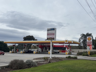 Sunshine and District Historical Society Incorporated
Photograph - Kealba - Service Station Photographs, John Alchin, 2026
... Station...Kealba...Sunshine Avenue...5864.01 - Sunshine Avenue 100 Kealba - Shell Service Station 2026.jpeg 5864.02 - Sunshine Avenue Cnr Main Road East Kealba - Ampol Service Station.jpeg...Service Station Kealba Sunshine Avenue 5864.01 - Sunshine Avenue 100 Kealba - Shell Service Station 2026.jpeg 5864.02 - Sunshine Avenue Cnr Main Road East Kealba - Ampol Service Station.jpeg Collection of digital colour photographs Photograph Kealba - Service Station Photographs John Alchin ...Collection of photographs of current and former service stations in the Kealba area.5864.01 - Sunshine Avenue 100 Kealba - Shell Service Station 2026.jpeg 5864.02 - Sunshine Avenue Cnr Main Road East Kealba - Ampol Service Station.jpegservice station, kealba, sunshine avenue -
Ringwood and District Historical Society
Envelope, Packet: Greenwood Sub-division (plans, 1924 notes etc)
... "Greenwood" subdivision, Greenwood Avenue & Station Street 22 pages plus several subdivisional plans....Ringwood and District Historical Society 125A Warrandyte Road Ringwood North melbourne "Greenwood" subdivision, Greenwood Avenue & Station Street 22 pages plus several subdivisional plans. ..."Greenwood" subdivision, Greenwood Avenue & Station Street 22 pages plus several subdivisional plans. -
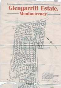 Greensborough Historical Society
Map, Glengarriff Estate Montmorency, 1938c
... avenue montmorency...montmorency station...Bordered by Sherbourne Avenue, Calrossie Avenue, Montmorency Station and Price Avenue...Bordered by Sherbourne Avenue, Calrossie Avenue, Montmorency Station and Price Avenue glengarriff estate montmorency sherbourne avenue montmorency calrossie avenue montmorency price avenue montmorency montmorency station Colour photocopy of subdivision map, on two A3 sheets Glengarriff Estate Montmorency Map T. ...Estate Agent's plan of Glengarriff Estate, Montmorency, covering LPs 11334 and 11451. Bordered by Sherbourne Avenue, Calrossie Avenue, Montmorency Station and Price AvenueColour photocopy of subdivision map, on two A3 sheets glengarriff estate montmorency, sherbourne avenue montmorency, calrossie avenue montmorency, price avenue montmorency, montmorency station -
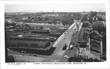 Melbourne Tram Museum
Postcard, Rose Stereograph Co, "Looking over Princes Bridge & The Yarra, Melbourne", c1941
... Rose Series postcard P.201, titled "Looking over Princes Bridge & The Yarra, Melbourne" with a view including Princes Bridge Railway Station, Batman Avenue. tram terminus with two trams, The Yarra River, the bridge, and the entrance to Flinders St station. ...Rose Series postcard P.201, titled "Looking over Princes Bridge & The Yarra, Melbourne" with a view including Princes Bridge Railway Station, Batman Avenue. tram terminus with two trams, The Yarra River, the bridge, and the entrance to Flinders St station. ...Rose Series postcard P.201, titled "Looking over Princes Bridge & The Yarra, Melbourne" with a view including Princes Bridge Railway Station, Batman Avenue. tram terminus with two trams, The Yarra River, the bridge, and the entrance to Flinders St station. The south west curve track from Swanston Street into Flinders Street is visible along with various Safety Zones at the tram stop.Yields information about St Kilda Road, Princes Bridge c1941Postcard - printed real photograph with Rose Stereograph Co. name on the rear. Two copies held.tramways, flinders st station, st kilda road, princes bridge station, princes bridge, yarra river, flinders st, trams, rose series -
 Chelsea & District Historical Society Inc
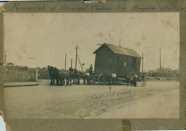
Photograph - Chelsea Fire Brigade, Relocating the Chelsea Fire Brigade Station
... Photograph sepia tones, features horses pulling a dray to move the Chelsea Fire Brigade Station from Nepean Highway to Station Street, opposite Catherine Avenue, Chelsea, 1927....Smith" Photograph sepia tones, features horses pulling a dray to move the Chelsea Fire Brigade Station from Nepean Highway to Station Street, opposite Catherine Avenue, Chelsea, 1927. Relocating the Chelsea Fire Brigade Station. ...Historic SocialPhotograph sepia tones, features horses pulling a dray to move the Chelsea Fire Brigade Station from Nepean Highway to Station Street, opposite Catherine Avenue, Chelsea, 1927."Removal of Original Chelsea Fire Brigade Station" / "Fire Station and Fire Brigade Chelsea being removed" / "Capt. J.J. Smith"chelsea fire brigade, chelsea -
 Chelsea & District Historical Society Inc
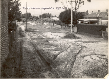
Photograph - First Avenue, Aspendale, 1949
... This photo is one of a collection of photos taken during Alan Niemann's - Drainage-Road Making Scheme. First Avenue runs between Station Street and Sixth Avenue....Chelsea & District Historical Society Inc The Chelsea Activity Hub 3-5 Showers Ave Chelsea 3196 melbourne This photo is one of a collection of photos taken during Alan Niemann's - Drainage-Road Making Scheme. First Avenue runs between Station Street and Sixth Avenue. unmade street Aspendale First Avenue Alan Niemann Drainage-Road Making Scheme Black and white photo looking east along First Avenue, Aspendale. ...This photo is one of a collection of photos taken during Alan Niemann's - Drainage-Road Making Scheme. First Avenue runs between Station Street and Sixth Avenue.Black and white photo looking east along First Avenue, Aspendale. The road us unmade and rusted with vegetation growing on the road, houses and electricity poles line both sides. unmade street, aspendale, first avenue, alan niemann, drainage-road making scheme -
 Ringwood and District Historical Society
Document - Map, Plan of Subdivision, Part of Crown Portion 11, Parish of Ringwood, County of Mornington - circa 1890
... A4 photocopy showing numbers and perimeter measurements of allotments on Station Street (previously Railway Avenue), Wantirna Road (previously West Prussia Road), James Street and Kendall Street (previously William Street). ...Notations include incorrect order of street name amendment between Station Street and Railway Avenue in 1952. Railway Avenue was re-named Station Street. ...Ringwood and District Historical Society 125A Warrandyte Road Ringwood North melbourne Notations include incorrect order of street name amendment between Station Street and Railway Avenue in 1952. Railway Avenue was re-named Station Street. ...A4 photocopy showing numbers and perimeter measurements of allotments on Station Street (previously Railway Avenue), Wantirna Road (previously West Prussia Road), James Street and Kendall Street (previously William Street). Notations include incorrect order of street name amendment between Station Street and Railway Avenue in 1952. Railway Avenue was re-named Station Street. Date missing from street name amendment from West Prussia Road to Wantirna Road. -
 Chelsea & District Historical Society Inc
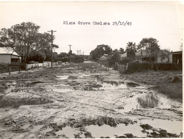
Photograph - Elsie Grove, Chelsea, 1949
... Elsie Grove runs between Station Street and Randal Avenue, Chelsea....Elsie Grove runs between Station Street and Randal Avenue, Chelsea. unmade street Aspendale Alan Niemann Drainage-Road Making Scheme Elsie Grove Black and white photo looking east along Elsie Grove, Chelsea. ...This photo is one of a collection of photos taken during Alan Niemann's - Drainage-Road Making Scheme. Elsie Grove runs between Station Street and Randal Avenue, Chelsea.Black and white photo looking east along Elsie Grove, Chelsea. The road is unmade and rutted with large puddles, houses line both sides and electricity poles are on the left side of the road. The photo has been taken from Station Street.unmade street, aspendale, alan niemann, drainage-road making scheme, elsie grove -
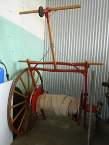 Kiewa Valley Historical Society
Fire Hose Reel, c1950s
... The practice strip was located beside the fire station in Lakeside Avenue. This fire hose reel was used by the Mt Beauty Fire Brigade for demonstrations at competitions during the 1950's and 1960's. ...The practice strip was located beside the fire station in Lakeside Avenue. This fire hose reel was used by the Mt Beauty Fire Brigade for demonstrations at competitions during the 1950's and 1960's. ...The fire hose reel was purchased by the Fire Ladies' Auxiliary for the Mt Beauty S.E.C. Fire Brigade in the late 1950's for over 1000 pounds. Initially they competed with Bogong fire brigade as both were 'Industry' Fire brigades - both owned by the State Electricity Commission. Competition was at 2 levels - north east Victoria and state competitions involving rural and urban brigades with a difference in the equipment. Mt Beauty was/is an urban brigade whereas Tawonga is a rural brigade. Competition involved members to improve their skill, keep fit and was a very social occasion. After the Shire took over Mt Beauty township in 1961, the Fire Brigade ran by itself but soon became affiliated with the C.F.A. because of insurance and legal liability e.g.. enabling them to stop traffic or wreck buildings if required. The CFA were not happy with the Mt Beauty truck so a new one was obtained while the old one went to Bogong. Competitions gradually ceased as it was a young man's sport and young members had prior commitments. The reel was donated to the KVHS in the mid 1980's as it failed to be sold as it competed with new, cheaper, aluminium reels. The practice strip was located beside the fire station in Lakeside Avenue. This fire hose reel was used by the Mt Beauty Fire Brigade for demonstrations at competitions during the 1950's and 1960's. The Mt Beauty Fire Brigade Team won the competition in 1966 at Wangaratta. The score was close against the home team and was decided on a play off. The team benefitted by the man who wound the hose on allowing it to end up at the easiest height to handle when full of water and very heavy.The Mt Beauty Fire Brigade was an 'industry' fire brigade belonging to the State Electricity Commission of Victoria from the 1940's. It became a member of the Country Fire Authority in the early 1960's. During the 1950's and early 1960's members would compete with other local fire brigades in competitions against other brigades in the north east of Victoria using skills such as unwinding the hose off the reel and turning on the water in record time. The Mt Beauty Fire Brigade continues today as an urban fire brigade affiliated with the CFA.Varnished wooden cart reinforced by painted red steel frame. The wheels have 14 wooden spokes and steel around the outside of the wooden wheel. A long canvas hose is wound around a central winding cylinder. The cart has a wooden handle with a rubber jockey wheel at its end. There is a brass hose nozzle attached by a stainless steel frame on the outer side near one of the wheels.Each Reel: "Mt Beauty F.B." yellow print outlined in black with red background.fire hose. mt beauty fire brigade. country fire authority. fire reel. -
 Ringwood and District Historical Society
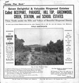
Pamphlet, Land Sale Brochure Titled Eureka Plan Book - Seven Delightful & Valuable Ringwood Estates - circa 1925
... Plan of Bestpart Estate, Ringwood, includes Bedford Road, Wilana Street, Greenwood Avenue, Caroline Street, Henry Street and Haig Street. Plan of Ringwood Station Estate includes Pitt Street, Bedford Road, Greenwood Avenue, Station Street, William Street (later Kendall Street, James Street, Wantirna Road, Caroline Street, Henry Street, Ellison Street and Haig Street. ...Plan of Bestpart Estate, Ringwood, includes Bedford Road, Wilana Street, Greenwood Avenue, Caroline Street, Henry Street and Haig Street. Plan of Ringwood Station Estate includes Pitt Street, Bedford Road, Greenwood Avenue, Station Street, William Street (later Kendall Street, James Street, Wantirna Road, Caroline Street, Henry Street, Ellison Street and Haig Street. ...Twenty page land sale brochure including photographs, subdivision features and local facilities. Additional flyer with conditions of sale and prices for estate blocks.Seven delightful and valuable Ringwood Estates called Bestpart, Paradise, Hill Top, Greenwood, Creek, Station, and School Estates. These nestle amidst the hills and valleys of beautiful Ringwood district. Also Goodluck Estate at Clarinda. Pamphlet marked as being From Mr. Farmer, No. 5 Flinders Court, Melbourne. Phone 988, 989 Central, or 55 Ringwood after 7 p.m. Plan of Ringwood School Estate includes William Street (later Kendall Street), Greenwood Avenue, Alton Street and Locke Street. Plan of Bestpart Estate, Ringwood, includes Bedford Road, Wilana Street, Greenwood Avenue, Caroline Street, Henry Street and Haig Street. Plan of Ringwood Station Estate includes Pitt Street, Bedford Road, Greenwood Avenue, Station Street, William Street (later Kendall Street, James Street, Wantirna Road, Caroline Street, Henry Street, Ellison Street and Haig Street. Plan of Geenwood Estate, Ringwood, includes Prussian Road (later Geenwood Avenue). Plan of Paradise Estate, Ringwood, includes Canterbury Road, Dandenong Road (Wantirna Road), Luck Street and Paradise Road. Plan of Creek Estate, Ringwood, includes Dandenong Creek, Wantirna Road and Gordon Crescent. Plan of Hill Top Estate, Ringwood (later Heathmont area), includes Heathmont Railway Station, Heathmont Road, Balfour Avenue, Lilian Street, Edith Street, Edna Street and Great Ryrie Street. Plan of Goodluck Estate, Clarinda, includes Talbot Avenue, Good Street, Luck Street, and Centre Road in locality plan between Oakleigh and Clayton Railway Stations. -
 Ringwood and District Historical Society
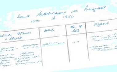
Document - Research Notes, Richard Carter, Land Subdivisions in Ringwood 1890-1950
... - after 1922) Lisgoold Street, Viviani Crescent, Balrour Avenue, Station Street (now part Heathmont Road and part Wainui Street) Pg13 RINGWOOD RAILWAY ESTATE LP10507 (1923) Whitehorse Road, Sherbrooke Avenue, Burwood Avenue, Bonview Avenue, Heatherbrae Avenue, Grant Crescent Pg14 GARDEN HOMES ESTATE (LP?) ...- after 1922) Lisgoold Street, Viviani Crescent, Balrour Avenue, Station Street (now part Heathmont Road and part Wainui Street) Pg13 RINGWOOD RAILWAY ESTATE LP10507 (1923) Whitehorse Road, Sherbrooke Avenue, Burwood Avenue, Bonview Avenue, Heatherbrae Avenue, Grant Crescent Pg14 GARDEN HOMES ESTATE (LP?) ...Handwritten table listing main local pre-1950s subdivisions in the Ringwood area, with estate names, streets, number of allotments for sale, and where known, vendor agent, LP (Lodged Plan) title registration number, and auction/sale date, some with sale price.Pg1 RINGWOOD STATION ESTATE LP3070 (Year?) Station Street, William Street (now Kendall Street), Wantirna Road, Station Street Pg1 RINGWOOD TOWNSHIP ESTATE LP5577 (1913) Station Road (now Warrandyte Road), Pratt Street (part now Aird Street), Whitehorse Road Pg2 RINGWOOD ORCHARD ESTATE LP4315 (1914) Brysons Road, Hillcrest Road, Anzac Avenue, Sulva Road Pg3 RINGWOOD RAILWAY ESTATE LP7522 (1918) Whitehorse Road (now Mount Dandenong Road), Dublin Road, Freeman Street, Patterson Street, Bona Street Pg4 THE RINGWOOD ESTATE LP7578 (1919) Warrandyte Road, Hobart Street, Paxton Street, Arnold Street Pg5 GARDEN FARMS ESTATE (LP?) (1919) Canterbury Road, Armstrong Road, Bungalook Road, Orchard Road, Bayswater Road (now Mountain Highway) Pg6 THE RINGWOOD ESTATE (SECOND SUB-DIVISION) LP7604 (1919) Warrandyte Road, Tamar Street, Derwent Street, Mersey Street Pg7 RINGWOOD STATION ESTATE LP7703 (1919) Bedford Road, Williams Grove (now Lena Grove) Pg8 RINGWOOD TOWNSHIP ESTATE LP8198 (1919) Wantirna Road, Ellison Street, Haig Street, Greenwood Avenue Pg9 EASTFIELD ESTATE (LP?) (1920) Eastfield Road, Longview Road, Pleasant Rise, The Mount Pg10 ELECTRIC RAILWAY ESTATE RINGWOOD LP9473 (1922) Campbell Street, Myrtle Avenue, George Street (now Tudor Court), Henry Street (now Myrtle Avenue), Williams Grove (now Lena Grove) Pg11 RINGWOOD PARK ESTATE LP7884 (1922 - two stages) Wonga Road (now Loughnan Road), William Street, Andrew Street, Harrison Street Pg12 HEATHMONT STATION ESTATE LP11009 (Date? - after 1922) Lisgoold Street, Viviani Crescent, Balrour Avenue, Station Street (now part Heathmont Road and part Wainui Street) Pg13 RINGWOOD RAILWAY ESTATE LP10507 (1923) Whitehorse Road, Sherbrooke Avenue, Burwood Avenue, Bonview Avenue, Heatherbrae Avenue, Grant Crescent Pg14 GARDEN HOMES ESTATE (LP?) (1923) Mullum Road, The Centreway, Wattle Crescent (now Wattle Avenue) Reserve Crescent (now Reserve Road) Pg15 DUBLIN ROAD ESTATE LP11993 (1923) Alexandra Road, Vonadawn Avenue, Green Street, Wood Street, Howard Avenue, Bedford Road, Dublin Road Pg16 CARLINGA ESTATE RINGWOOD LP9620 (1923) Bourke Street, Bond Street, Ringwood Street Pg17 PRATT'S JUNCTION ESTATE (LP?) (1923) Junction Street, Georges Road, Oliver Street, Whitehorse Road Pg18 EAST RINGWOOD ESTATE LP10492 (1923) Bona Street, Patterson Street, Miller Grove, Fairview Avenue, Eastfield Road, Whitehorse Road (now Mount Dandenong Road) Pg19 COLEMAN'S HEATHMONT ESTATE LP9974 (1923) Canterbury Road, Bedford Road, Alvena Crescent, Coleman Street, Leonard Street (now Royal Avenue) Pg20 RINGWOOD HEIGHTS ESTATE LP10506 (1924) Whitehorse Road, Bonview Avenue, Grant Crescent, Hillcrest Avenue, Heatherbrae Avenue, Margaret Street, Mary Street Pg21 EAST RINGWOOD STATION ESTATE LP10551 (1924) Knaith Road, Wenwood Street, Lois Street, Victoria Street, Station Street (now Railway Avenue) Pg22 GRAND VIEW ESTATE LP11019 (1924) Whitehorse Road, Rupert Street, Herbert Street, Leonard Street Pg23 RINGWOOD RAILWAY ESTATE & RINGWOOD HEIGHTS ESTATE - FINAL SECTIONS LP10506 & LP10507 (1924) Whitehorse Road, Sherbrooke Avenue, Burwood Avenue, Bonview Avenue, Heatherbrae Avenue, Margaret Street, Mary Street, Grant Crescent Pg24 RINGWOOD EAST ELECTRIC STATION ESTATE (LP?) (1924) Railway Parade (now Patterrson Street), Federal Road, Howship Avenue (part now French Street), Dublin Road, Rosedale Crescent Pg25 BEDFORD PARK (now Ringwood Secondary College) (LP?) (1924) Bedford Road, Adams Street, Anderson Street, Joyce Street, Graham Road Pg26 CROWN JEWEL ESTATE LP11645 (Private sales after 1924) Mount Dandenong Road, Mirabel Avenue, Valda Avenue, Evon Avenue, Velma Grove Pg27 GRAND CENTRAL ESTATE LP10917 (1925) Heathmont Road, Great Ryrie Street, Douglas Street, Garden Street, Bellevue Avenue Pg28 RINGWOOD (unnamed estate - 1926) Nelson Street, Seymour Street, Whitehorse Road Pg29 EAST RINGWOOD RAILWAY STATION ESTATE (YEAR? - 25 shops 60 villas) Railway Avenue, Dublin Road, Lawrence Grove, Stanley Avenue, Knaith Road Pg30 CHARM VIEW ESTATE (LP?) (year? - after 1926) Canterbury Road, Heathmont Road, Dickasons Road, Bennjett Avenue, Orchid Street Pg31 SUNBEAM ESTATE LP12150 (Circa 1925) Govt Road (now Old Lilydale Road), Sunbeam Avenue, Holland Road, Everard Street (now Everard Road) Pg32 FAIRVIEW ESTATE EAST RINGWOOD LP10853 (Circa 1924) Eastfield Road, Patterson Street, Margaret Street (now Short Street) Pg33 EAST RINGWOOD TOWNSHIP ESTATE LP3025 (Circa 1924 - 35 allotments) Mount Dandenong Road, Grey Street, Eastfield Road Pg34 EAST RINGWOOD TOWNSHIP ESTATE LP3025 (Circa 1924 - 49 allotments) and STATE SCHOOL ESTATE (26 allotments) and EAST RINGWOOD STATION ESTATE (14 shop sites) Mount Dandenong Road, Grety Street, Dunn Street, Eastfield Road, King Street, Holland Road, Dublin Road, Patterson Street, Bona Street Pg35 EAST RINGWOOD CENTRAL ESTATE LP17004 (1948) Knaith Road, Shasta Avenue, Talofa Avenue, Russet Road, Dublin Road Pg36 WARE ESTATE LP43360 (1958) Ware Crescent, Davey Drive, Grey Road (now Grey Street), Mount Dandenong Road Pg37 Lot 57 Kendall Street LP3070 (1939) £75.0.0 Pg37 Lot 14 LP7346 (year?) £225 Pg37 Lot 8 WHITE HORSE ESTATE LP14010 (year?) Maroondah Hwy, Seymour Street £98.9.0 Pg37 Lots 4-14 incl. LP10902 (year?) £300 Pg37 Lots 69&70 LP2216 (1939) Bedford Road, Pitt Street £500 Pg37 Lots 60&70 LP2216 (year?) £460 Pg37 MOUNTAIN VIEW ESTATE LP10902 (1936) Lots 1&2, 19-22 Wantirna Road, Daisy Street £50 Pg38 RAILWAY STATION ESTATE RINGWOOD EAST LP7522 (1925) Lots 16 to 19 £250 Pg38 RINGWOOD PARK ESTATE (LP?) (1924) Lot 112 Munro Street £230 Pg38 RINGWOOD TOWNSHIP ESTATE (LP?) (1925) Lot 57 Wantirna Road £850 Pg38 ELECTRIC RAILWAY ESTATE LP9473 (1925) Lot 98 & 99 £180 (30/- foot) Pg38 ELECTRIC RAILWAY ESTATE LP9473 (year?) Lot 100 £233.12.6 incl improvements (£2.12.6 foot) Pg38 Lot 22&23 Bedford Road Heathmont (LP & year?) £675 incl improvements Pg39 Lot 9 Mullum Mullum Road LP8221 (1923) £150 Pg39 Lot 27 Haig Street LP8198 (1925) £825 Pg39 Lot 56 Haig Street cnr Wantirna Road LP8198 (1923) £171 Pg39 Lots 3 & 4 Loughnan Road LP9626 (192?) £147 Pg39 Lots 98 & 99 Myrtle Avenue LP9473 (1925) £180 Pg39 Lots 80 & 81 Myrtle Avenue LP9473 (1929) £150 Pg39 Lot 30 Sherbrooke Avenue LP10507 (1926) £700 incl improvements Pg40 Lot 10 (year?) LP7703 £750 Pg40 Lot 36 (year?) LP7522 £25 Pg40 Lot 38 Pitt Street LP2216 (year?) £350 Pg40 Lot 7 Dublin Road cnr Green Street LP11993 (year?) £300 -
 Victoria Police Museum
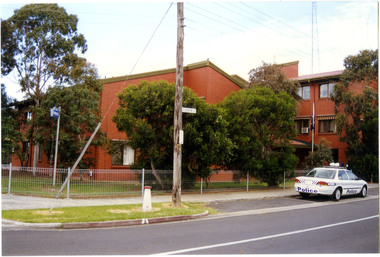
Police Stations (Altona North)
... Altona North Police Station opened on 7 October 1979 as a new twenty-four police station and was the District Headquarters of Altona District. It comprised a C.I.B. and a Community Policing Squad. It is located at 72 Cooper Avenue...Altona North Police Station opened on 7 October 1979 as a new twenty-four police station and was the District Headquarters of Altona District. It comprised a C.I.B. and a Community Policing Squad. It is located at 72 Cooper Avenue ...Altona North is a suburb of Melbourne, Victoria, Australia, 10 km south-west of Melbourne's Central Business District, located within the City of Hobsons Bay local government area. Altona North Police Station opened on 7 October 1979 as a new twenty-four police station and was the District Headquarters of Altona District. It comprised a C.I.B. and a Community Policing Squad. It is located at 72 Cooper Avenue, on the corner of McArthurs Road. A new police station is being planned for Galvin Street, opening in 2020.2 colour photospolice stations; altona north police station -
 Federation University Historical Collection
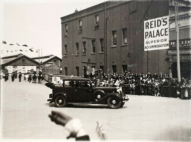
Photograph, Reid's Coffee Palace, Lydiard Street, Ballarat, c1930s ?
... Avenue of Honour? There is a band in the background. Note the folded back roof which allows the passenger to be seen by the public. https://architectureau.com/articles/heritage-listed-gold-rush-era-ballarat-coffee-palace-receives-700000-conservation-grant/ reid's coffee palace ballarat railway station visitor bunting celebration Ballarat Verso - Post (Correspondence) Black and white photos of a car leaving the Ballarat Station (possibly carrying William Birdwood?). ...The special guest in the car appears to have arrived in Ballarat by train. Could it be William Birdwood to plant trees in the Ballarat Avenue of Honour? There is a band in the background. Note the folded back roof which allows the passenger to be seen by the public. https://architectureau.com/articles/heritage-listed-gold-rush-era-ballarat-coffee-palace-receives-700000-conservation-grant/Black and white photos of a car leaving the Ballarat Station (possibly carrying William Birdwood?). Reid's Coffee Palace is in the background Verso - Post (Correspondence)reid's coffee palace, ballarat railway station, visitor, bunting, celebration, ballarat -
 Bright & District Historical Society operating the Bright Museum
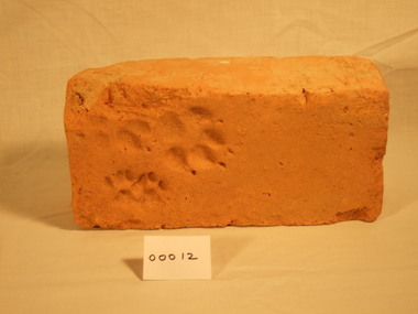
Brick, handmade
... Bright & District Historical Society operating the Bright Museum 2 Station Street Bright high-country Henry Oakes' kiln was located near the current council depot in Churchill Avenue,Bright. handmade brick oakes kiln Animal paw prints- 2 sets. ...Henry Oakes' kiln was located near the current council depot in Churchill Avenue,Bright.Handmade brick of pale orange clay. Two corners damaged.Animal paw prints- 2 sets.handmade, brick, oakes, kiln -
Federation University Historical Collection
Report, Cultural Landscapes Study of Creswick Goldfields Area for Australian Hertiage Commission
... station...creswick school of forestry...sawpit gully...oak gully...creswick cemetery...kingston...creswick avenue...Barker Library (top floor) Mount Helen goldfields goldfields of victoria goldfields tourism marketing tourism creswick creswick goldfields allendale broomfield rocklyn bullengarook mollongghip dean scrub hill clarkes hill creswick railway station creswick school of forestry sawpit gully oak gully creswick cemetery kingston creswick avenue of honour kerrins bridge berry deep leads mine system australasian mine site creswick alluvial workings calembeen park ascot anderson's mill smeaton hepburn lagoon White bound report with clear cover Cultural Landscapes Study of Creswick Goldfields Area for Australian Hertiage Commission Report Chris McConville Chris Olver ...White bound report with clear covergoldfields of victoria, goldfields tourism, marketing, tourism, creswick, creswick goldfields, allendale, broomfield, rocklyn, bullengarook, mollongghip, dean, scrub hill, clarkes hill, creswick railway station, creswick school of forestry, sawpit gully, oak gully, creswick cemetery, kingston, creswick avenue of honour, kerrins bridge, berry deep leads mine system, australasian mine site, creswick alluvial workings, calembeen park, ascot, anderson's mill, smeaton, hepburn lagoon -
 Eltham District Historical Society Inc
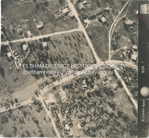
Photograph - Aerial Photograph, Main Road, intersection Grand Boulevard and Panorama Avenue, Lower Plenty / Montmorency, 2 Jul. 1951
... Station...Beleura Grove...Grand Boulevard...Looker Road...Lower Plenty...Montmorency...Panorama Avenue...Eltham District Historical Society Inc 728 Main Rd Eltham melbourne Not originally catalogued in Shire of Eltham Archives but from the same series of photos taken for Country Road Board study of Main Road widening shire of eltham archives Aerial Photo Country Roads Board Eltham Main Road Road widening 1951-07 Airlie Road Ambulance Station Beleura Grove Grand Boulevard Looker Road Lower Plenty Montmorency Panorama Avenue Black and white proto print Size: 245x230 mm Condition: good Main Road, intersection Grand Boulevard and Panorama Avenue, Lower Plenty / Montmorency Photograph Aerial Photograph ...Not originally catalogued in Shire of Eltham Archives but from the same series of photos taken for Country Road Board study of Main Road wideningshire of eltham archives, aerial photo, country roads board, eltham, main road, road widening, 1951-07, airlie road, ambulance station, beleura grove, grand boulevard, looker road, lower plenty, montmorency, panorama avenue