Showing 295 items matching "stawell map"
-
 Stawell Historical Society Inc
Map, Section of Map, Stawell including Stawell Rifle Range, 1969
... Section of Map, Stawell including Stawell Rifle Range...Section of Map, Stawell including Stawell Rifle Range...Stawell Historical Society Inc 46 Longfield St Stawell grampians Stawell Section of Map, Stawell including Stawell Rifle Range Section of Map, Stawell including Stawell Rifle Range Map ...Section of Map, Stawell including Stawell Rifle Rangestawell -
Stawell Historical Society Inc
Map, Local Map of Stawell and District
... Local Map of Stawell and District...Local Map of Stawell and District...Stawell Historical Society Inc 46 Longfield St Stawell grampians Stawell Local Map of Stawell and District Local Map of Stawell and District Map ...Local Map of Stawell and Districtstawell -
Stawell Historical Society Inc
Map, Section of Map, Mining, Stawell
... Section of Map, Mining, Stawell ...Section of Map, Mining, Stawell ...Stawell Historical Society Inc 46 Longfield St Stawell grampians Stawell Section of Map, Mining, Stawell Section of Map, Mining, Stawell Map ...Section of Map, Mining, Stawell stawell -
Stawell Historical Society Inc
Map, Easton Johnstone, Map of Stawell Surveyed by Easton Johnstone 1872, 1872
... Map of Stawell Surveyed by Easton Johnstone 1872...A2 map of Stawell Reefs Area. Showing Crushing Machines & Title Info... of Stawell Reefs Area. Showing Crushing Machines & Title Info Map of Stawell Surveyed by Easton Johnstone 1872 Map Easton Johnstone ...Victoria Co Crushing Machine. St Georges Co Crushing machine. Wimmera Co Crushing Machine. Government Reservoir and Drainage. Sloan Street, Skene Street Mines. old Mine WorkingsA2 map of Stawell Reefs Area. Showing Crushing Machines & Title InfoSurveyed by Easton Johnstone Contract Surveyor. Photo-Lithographed at the Department of Lands & Survey. Melbourne By J Noone 9th May 1872mining -
Stawell Historical Society Inc
Map, CFA, Map of Stawell / deep Lead Fire of 31/12/2005, 2006
... Map of Stawell / deep Lead Fire of 31/12/2005...Laminated Coloured Map of Stawell / Deep Lead 4/1/2006 with Fire Perimeters.... of Stawell / Deep Lead 4/1/2006 with Fire Perimeters. Map of Stawell / deep Lead Fire of 31/12/2005 Map CFA ...Fire Started from lightning strike near Deep Lead and Burned on New years Eve with nasty North Wind, Southerly to Black range, Then Easterly towards Great western. Fire Subduded by Rain Event on 2/1/2006.Laminated Coloured Map of Stawell / Deep Lead 4/1/2006 with Fire Perimeters.CFA GIS Services Community Services -
Stawell Historical Society Inc
Map, Township of Stawell Photo Map, 1947
... Township of Stawell Photo Map...Shows mining sites and township Township of Stawell Photo Map Map ...Photograph of Stawell from Air Circa 1947. Shows mining sites and townshipmining, gold, map -
Stawell Historical Society Inc
Map, Stawell Gold Mine, Stawell Gold Mine Photo Map of Stawell Township showing Underground Declines in mining lease, 2007
... Stawell Gold Mine Photo Map of Stawell Township showing Underground Declines in mining lease....Map Stawell Gold Mine ...SGM photo Map 2007 Produced for Public Consultation over Big Hill Open Pit Proposal. Aerial Views Stawellmining, gold, map -
Stawell Historical Society Inc
Map, Topographic Map Stawell North
... Topographic Map Stawell North...Stawell Historical Society Inc 46 Longfield St Stawell grampians Mapping Stawell North 7423-1-N Topographic Map 1:25000 Coloured 1990 Topographic Map Stawell North Map ...Topographic Map 1:25000 Coloured 1990Stawell North 7423-1-Nmapping -
Stawell Historical Society Inc
Map, Topographic Map Stawell South
... Topographic Map Stawell South...Stawell Historical Society Inc 46 Longfield St Stawell grampians Mapping Stawell South 7423-1-S Topographic Map 1:25000 Coloured 1990 Topographic Map Stawell South Map ...Topographic Map 1:25000 Coloured 1990Stawell South 7423-1-Smapping -
Stawell Historical Society Inc
Map, Department of Mines Victoria, Alluvial Map Stawell Region, 1870's
... Alluvial Map Stawell Region...c1870 Coloured map showing Black Range North to Stawell and Illawarra. Shows geological layout....Shows geological layout. Alluvial Map Stawell Region Map Department of Mines Victoria ...c1870 Coloured map showing Black Range North to Stawell and Illawarra. Shows geological layout.Department Mines Victoria 1952/G/2 mining, gold, map -
Stawell Historical Society Inc
Map, Stawell Joint Venture, Map of Stawell showing Mining Lease Boundary and Freehold Land, September 1988
... Map of Stawell showing Mining Lease Boundary and Freehold Land...Stawell Historical Society Inc 46 Longfield St Stawell grampians mining gold map Stawell Joint Venture Map of Stawell showing Mining Lease Boundary and Freehold Land Map Stawell Joint Venture ...Stawell Joint Venturemining, gold, map -
 Stawell Historical Society Inc
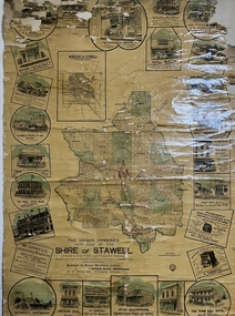
Advertising Material, Wall map of Stawell Shire & Borough of Stawell. Supplement Stawell Times & Wimmera Advertiser
... Wall map of Stawell Shire & Borough of Stawell. Supplement Stawell Times & Wimmera Advertiser ...Large Paper Wall map coloured with cloth backing. Maps of Shire & Borough of Stawell & Advertising ...The Unique Combine's New map of the Shire of Stawell Compiled by H. E. Ward late Government Draftsmann ...Ward late Government Draftsmann Large Paper Wall map coloured with cloth backing. Maps of Shire & Borough of Stawell & Advertising Wall map of Stawell Shire & Borough of Stawell. ...Advertised Stawell Businesses W. Whiteside, Taylor Clothiers Main Stree.t Mitchell Brothers Auctioneers, Stock & Station Agents, Stawell. The Stawell Times & Wimmera Advertiser, R.W. Baxter Manager. J. H. Stabb, Coach Builder. Isaac Cook, Saddler. Main Street Stawell. Gustav Mahnke. Fancy Bread and Biscuit Baker. McMullin Bros, Produce Merchants and Family Grocer. L.C. Phillips, Taylor & Clothier, Main Street Stawell. Victoria House, George Sprague, Family Draper Main Street. Josiah Cook Butchers, Main Street. The Town Hall Hotel, Wm Short, Main Street. R. H. Wadsworth. Practical Watchmaker & Jeweler. Main Street Stawell. John Allingham, Importer General Draper and Outfitter. Boot & Shoe Warehouse. W. Laxton. Boot and Shoe Manufacturer. Stawell Boot Factory, Main Street Stawell. Anthony Bone, Saddler, Main Street Stawell. Stawell Brewery. G. Bryant & Co. H. Edhouse Manager, Stawell West. The Stawell Coffee Palace, Main Street. T. Aldred Proprieter. S. Isaacson, Draper & Clothier . Main Street Stawell. The Wimmera Flour Mill Co. Ltd. W. Frayne, Manager. George Kay & Co. (Late Wayman & Kay) Iron & Brass Founders, Engineers , Etc Stawell. Large Paper Wall map coloured with cloth backing. Maps of Shire & Borough of Stawell & Advertising The Unique Combine's New map of the Shire of Stawell Compiled by H. E. Ward late Government Draftsmann businesses -
Stawell Historical Society Inc
Map, Township of Stawell
... Showing Special Allotments Reefs, Pleasant Creek Parish of Stawell. Map No L4000...Showing Special Allotments Reefs, Pleasant Creek Parish of Stawell. Map No L4000 Township of Stawell Map ...B/W map of Stawell Surveyed by Easton Johnston Contract surveyor Scale in Chains. Showing Special Allotments Reefs, Pleasant Creek Parish of Stawell. Map No L4000 -
 Stawell Historical Society Inc
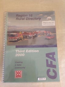
Book, Country Fire Authority, Region 16 Rural Directory, Third Edition 2000 - Country Fire Authority - Previously Cat No 3635A, 2000
... stawell map...Stawell Historical Society Inc 46 Longfield St Stawell grampians A Book of Maps in region 16 for use by the fire brigade in case of bushfires. stawell map Region 16 Rural Directory Third Edition 2000 Creating a safer community CFA Clear Plastic cover, with wire binding over green cover with colour photo of four fire tucks and another fire vehicle with people standing in front of the trucks. ...A Book of Maps in region 16 for use by the fire brigade in case of bushfires.Clear Plastic cover, with wire binding over green cover with colour photo of four fire tucks and another fire vehicle with people standing in front of the trucks. Region 16 Rural Directory Third Edition 2000 Creating a safer community CFAstawell map -
 Stawell Historical Society Inc
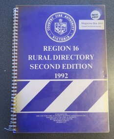
Book, Country Fire Authority, Region 16 Rural Directory, Second Edition 1992 - Country Fire Authority - Previously Cat No 3635, 1992
... stawell map...A book of maps of region 16 for use by the CFA in bushfires stawell map Region 16 Rural Directory Second Edition 1992 Published by The Country Fire Authority Mapping Association INc. ...A book of maps of region 16 for use by the CFA in bushfires Clear Plastic cover with wire spiral binding, over pruple paper with CFA Logo and White Stripes in the lower halfRegion 16 Rural Directory Second Edition 1992 Published by The Country Fire Authority Mapping Association INc. Sold by Country Fore Authority Regio 16 Headquarters 390 Barkly Street Ararat 3377stawell map -
Stawell Historical Society Inc
Document - Photo Map, 1950
... Photo Map. Stawell A1, Zone 6....Stawell Historical Society Inc 46 Longfield St Stawell grampians Stawell Photo Map. Stawell A1, Zone 6. Document Photo Map ...Photo Map. Stawell A1, Zone 6.stawell -
Stawell Historical Society Inc
Document - Photo Map, 1950
... Photo Map. Stawell A2, Zone 6....Stawell Historical Society Inc 46 Longfield St Stawell grampians Stawell Photo Map. Stawell A2, Zone 6. Document Photo Map ...Photo Map. Stawell A2, Zone 6.stawell -
Stawell Historical Society Inc
Document - Photo Map, 1950
... Photo Map. Stawell A3, Zone 6....Stawell Historical Society Inc 46 Longfield St Stawell grampians Stawell Photo Map. Stawell A3, Zone 6. Document Photo Map ...Photo Map. Stawell A3, Zone 6.stawell -
Stawell Historical Society Inc
Document - Photo Map, 1950
... Photo Map. Stawell A4, Zone 6....Stawell Historical Society Inc 46 Longfield St Stawell grampians Stawell Photo Map. Stawell A4, Zone 6. Document Photo Map ...Photo Map. Stawell A4, Zone 6.stawell -
Stawell Historical Society Inc
Document - Photo Map, 1952
... Photo Map. Stawell B2, Zone 6....Stawell Historical Society Inc 46 Longfield St Stawell grampians Stawell Photo Map. Stawell B2, Zone 6. Document Photo Map ...Photo Map. Stawell B2, Zone 6.stawell -
Stawell Historical Society Inc
Document - Photo Map, 1952
... Photo Map. Stawell B3, Zone 6....Stawell Historical Society Inc 46 Longfield St Stawell grampians Stawell Photo Map. Stawell B3, Zone 6. Document Photo Map ...Photo Map. Stawell B3, Zone 6.stawell -
Stawell Historical Society Inc
Document - Photo Map, 1952
... Photo Map. Stawell B4, Zone 6....Stawell Historical Society Inc 46 Longfield St Stawell grampians Stawell Photo Map. Stawell B4, Zone 6. Document Photo Map ...Photo Map. Stawell B4, Zone 6.stawell -
Stawell Historical Society Inc
Document - Photo Map, 1950
... Photo Map. Stawell C1, Zone 6....Stawell Historical Society Inc 46 Longfield St Stawell grampians Stawell Photo Map. Stawell C1, Zone 6. Document Photo Map ...Photo Map. Stawell C1, Zone 6.stawell -
Stawell Historical Society Inc
Document - Photo Map, 1950
... Photo Map. Stawell C2, Zone 6....Stawell Historical Society Inc 46 Longfield St Stawell grampians Stawell Photo Map. Stawell C2, Zone 6. Document Photo Map ...Photo Map. Stawell C2, Zone 6.stawell -
Stawell Historical Society Inc
Document - Photo Map, 1952
... Photo Map. Stawell C3, Zone 6....Stawell Historical Society Inc 46 Longfield St Stawell grampians Stawell Photo Map. Stawell C3, Zone 6. Document Photo Map ...Photo Map. Stawell C3, Zone 6.stawell -
Stawell Historical Society Inc
Document - Photo Map, 1952
... Photo Map. Stawell C4, Zone 6....Stawell Historical Society Inc 46 Longfield St Stawell grampians Stawell Photo Map. Stawell C4, Zone 6. Document Photo Map ...Photo Map. Stawell C4, Zone 6.stawell -
Stawell Historical Society Inc
Document - Photo Map, 1952
... Photo Map. Stawell D1, Zone 6....Stawell Historical Society Inc 46 Longfield St Stawell grampians Stawell Photo Map. Stawell D1, Zone 6. Document Photo Map ...Photo Map. Stawell D1, Zone 6.stawell -
Stawell Historical Society Inc
Document - Photo Map, 1948
... Photo Map. Stawell D2, Zone 6....Stawell Historical Society Inc 46 Longfield St Stawell grampians Stawell Photo Map. Stawell D2, Zone 6. Document Photo Map ...Photo Map. Stawell D2, Zone 6.stawell -
Stawell Historical Society Inc
Document - Photo Map, 1948
... Photo Map. Stawell D3, Zone 6....Stawell Historical Society Inc 46 Longfield St Stawell grampians Stawell Photo Map. Stawell D3, Zone 6. Document Photo Map ...Photo Map. Stawell D3, Zone 6.stawell -
Stawell Historical Society Inc
Document - Photo Map, 1948
... Photo Map. Stawell D4, Zone 6....Stawell Historical Society Inc 46 Longfield St Stawell grampians Stawell Photo Map. Stawell D4, Zone 6. Document Photo Map ...Photo Map. Stawell D4, Zone 6.stawell