Showing 130 items matching "stonework"
-
 St Kilda Historical Society
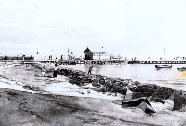
Drawing - Sketch, St Kilda Pier and stonework, c. 1897
... St Kilda Pier and stonework...on back: Sketch St Kilda Pier and Stonework Circa 1897. Copied by State Library 11 May 1982 51002...Sketch StKilda Pier and Stonework - Circa 1897. Copied by State Library of Victoria 11 May 1982, 51002. c100 Historical Society of st Kilda....St Kilda Historical Society St Kilda Branch Library 150 Carlisle Street St Kilda melbourne on back: Sketch St Kilda Pier and Stonework Circa 1897. Copied by State Library 11 May 1982 51002 Sketch StKilda Pier and Stonework - Circa 1897. ...on back: Sketch St Kilda Pier and Stonework Circa 1897. Copied by State Library 11 May 1982 51002glossy copy of a sketch fair conditionSketch StKilda Pier and Stonework - Circa 1897. Copied by State Library of Victoria 11 May 1982, 51002. c100 Historical Society of st Kilda. -
 Ballarat Heritage Services
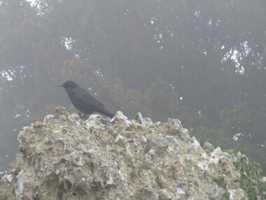
Photograph - Photograph - Colour, Greenwich Chapel and Museum, England, Mason's Mark on stonework, 2017
... Greenwich Chapel and Museum, England, Mason's Mark on stonework...Colour photograph of Greenwich Chapel and Museum, England, Mason's Mark on stonework...In 2005 while monitoring the digging of a drainage trench archaeologists found brickwork and tiles that formed the floor of the east end of the Tudor Chapel Royal where the altar once stood. greenwich, stone, museum, chapel Colour photograph of Greenwich Chapel and Museum, England, Mason's Mark on stonework Greenwich Chapel and Museum, England, Mason's Mark on stonework Photograph Photograph - Colour ...Greenwich Palace no longer exists however archaeology had added greatly to our understanding of life at the Tudor Court at Greenwich. Since 1971 there have been well over 20 digs on the site. Many wonderful and intriguing items from gold coins to tiled floors and human skeletons have been found. The first major dig uncovered the structure of the royal apartments next to the river. Not only did it clarify the floor plan but finds included some rare Tudor ceiling decorations, a hoard of gold coins and many personal items such as dice used for gaming. Perhaps the most revealing excavations have been the most recent. In 2005 while monitoring the digging of a drainage trench archaeologists found brickwork and tiles that formed the floor of the east end of the Tudor Chapel Royal where the altar once stood.Colour photograph of Greenwich Chapel and Museum, England, Mason's Mark on stoneworkgreenwich, stone, museum, chapel -
 Ballarat Heritage Services
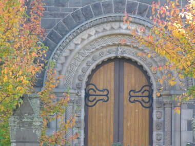
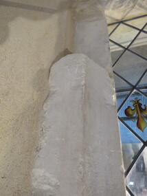
Photograph - Photograph - Colour, Stonework around door, St Andrew's, Sturt Street, Ballarat, c2017
... Stonework around door, St Andrew's, Sturt Street, Ballarat....Colour photograph of Stonework around door, St Andrew's, Sturt Street, Ballarat....Stonework around door, St Andrew's, Sturt Street, Ballarat. ...Colour photograph of Stonework around door, St Andrew's, Sturt Street, Ballarat.ballarat, church, st andrew's, stone, st andrew's kirk ballarat, architecture -
 Stawell Historical Society Inc
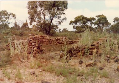
Photograph, Remains of stonework walls of a Chinaman's house at Deep Lead
... Remains of stonework walls of a Chinaman's house at Deep Lead...2 Colour Photographs: Remains of stonework walls of a house at Deep Lead (Chinaman's). ...He was a Market Gardener Remains of stonework walls of a Chinaman's house at Deep Lead Photograph ...2 Colour Photographs: Remains of stonework walls of a house at Deep Lead (Chinaman's). He was a Market Gardenerdeep lead, chinaman's -
 Stawell Historical Society Inc
Photograph, Remains of stonework walls of a house at Deep Lead
... Remains of stonework walls of a house at Deep Lead ...2 Colour Photographs: Remains of stonework walls of a house at Deep Lead (Chinaman's). ...He was a Market Gardener Remains of stonework walls of a house at Deep Lead Photograph ...2 Colour Photographs: Remains of stonework walls of a house at Deep Lead (Chinaman's). He was a Market Gardenerdeep lead, chinaman's -
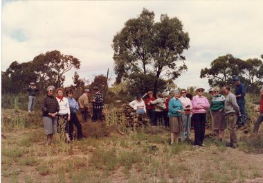
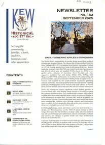 University of Melbourne, Burnley Campus Archives
Newsletter, Verna Rieschild, Oaks, Flowering Apples & Stonework, September 2025
... Oaks, Flowering Apples & Stonework...Article by Verna Rieschild, "Oaks, Flowering Apples & Stonework," about the gardens in Kew, Victoria that Edna Walling designed....Oaks, Flowering Apples & Stonework Newsletter Verna Rieschild Kew Historical Society ...kew historical society, newsletter, verna rieschild, garden design, gardens in kew, edna walling -
 Ringwood and District Historical Society
Photograph, Unknown stonework house, maybe in Ringwood circa 1965
... Unknown stonework house, maybe in Ringwood circa 1965...Ringwood and District Historical Society 125A Warrandyte Road Ringwood North melbourne Unknown stonework house, maybe in Ringwood circa 1965 Photograph ... -
 Ballarat Heritage Services
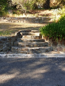
Photograph - Photograph - Colour, The Edna Walling inspired stonework at Locarno Spring in the Hepburn Springs Reserve, 2020, 12/12/2020
... The Edna Walling inspired stonework at Locarno Spring in the Hepburn Springs Reserve, 2020...In 1934 there was a proposal to spend 2,000 to 3,000 pounds at the Hepburn Springs Reserve, with a govenrment loan suggested. hepburn springs mineral water Hepburn Springs Reserve Edna Walling Colour photograph of the stone bridge at Locarno Spring in the Hepburn Springs Reserve, with the new 'placed' rocks in the surrounds c2000 The Edna Walling inspired stonework at Locarno Spring in the Hepburn Springs Reserve, 2020 Photograph Photograph - Colour Clare Gervasoni ...The Hepburn Springs Progress Association invited Edna Walling the the Hepburn Springs Reserve, and sandstone paths and bridges resulted. In 1934 there was a proposal to spend 2,000 to 3,000 pounds at the Hepburn Springs Reserve, with a govenrment loan suggested. Colour photograph of the stone bridge at Locarno Spring in the Hepburn Springs Reserve, with the new 'placed' rocks in the surrounds c2000hepburn springs, mineral water, hepburn springs reserve, edna walling -
 Ballarat Heritage Services
Photograph - Colour, Greenwich Chapel and Museum, England, Mason's Mark on stonework
... Greenwich Chapel and Museum, England, Mason's Mark on stonework...In 2005 while monitoring the digging of a drainage trench archaeologists found brickwork and tiles that formed the floor of the east end of the Tudor Chapel Royal where the altar once stood. greenwich, stone, museum, chapel Greenwich Chapel and Museum, England, Mason's Mark on stonework Photograph - Colour ...Greenwich Palace no longer exists however archaeology had added greatly to our understanding of life at the Tudor Court at Greenwich. Since 1971 there have been well over 20 digs on the site. Many wonderful and intriguing items from gold coins to tiled floors and human skeletons have been found. The first major dig uncovered the structure of the royal apartments next to the river. Not only did it clarify the floor plan but finds included some rare Tudor ceiling decorations, a hoard of gold coins and many personal items such as dice used for gaming. Perhaps the most revealing excavations have been the most recent. In 2005 while monitoring the digging of a drainage trench archaeologists found brickwork and tiles that formed the floor of the east end of the Tudor Chapel Royal where the altar once stood.greenwich, stone, museum, chapel -
 Ballarat Heritage Services
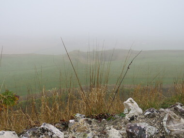
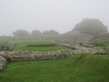
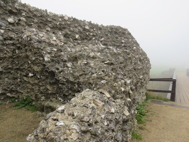
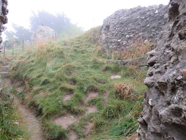
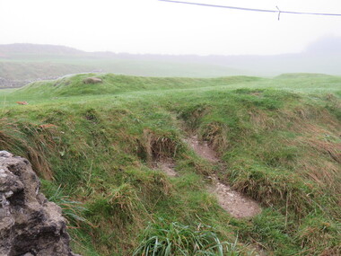
Photograph - Colour, looking from Stonework towards earth mounds, Old Sarum, England, English Heritage Site, 2016, 01 November 2016
... looking from Stonework towards earth mounds, Old Sarum, England, English Heritage Site, 2016...The nearer end of Mudge's line is marked by an inscribed stone beside the modern A345 at Old Sarum. ordnance survey, william mudge, jesse ramsden, william the conqueror, old sarum, saxon, 1086, england looking from Stonework towards earth mounds, Old Sarum, England, English Heritage Site, 2016 Photograph - Colour ...William the Conqueror inherited Old Sarum from the last Saxon king of England. It was an ideal site for a royal castle. It was here in 1070 that William paid off his army after a long and bitter campaign in northern England. It was here in 1086 that he called together all the major landholders in England so they could swear allegiance to him. It was a crucial moment. The Domesday Book was being written, a threatened Viking invasion had only just been averted and William's eldest son was in armed rebellion. Old Sarum was an important place where this Norman king of England held power. In 1794 the Ordnance Survey set out to check the accuracy of the first mapping of Southern England, which had begun ten years earlier. From a point just below Old Sarum Lieutenant William Mudge laid out a base-line 36,574 feet (11,253 metres) long. From each end of the line the positions of distant places were plotted using a huge theodolite made in 1791 by Jesse Ramsden. The accuracy of the process, which was repeated all over England, depended on Jesse Ramsden's craftsmanship and on William Mudge's surveying skill in setting out this first base-line from Old Sarum. The nearer end of Mudge's line is marked by an inscribed stone beside the modern A345 at Old Sarum. ordnance survey, william mudge, jesse ramsden, william the conqueror, old sarum, saxon, 1086, england -
 Ballarat Heritage Services
Photograph - Colour, Looking from Stonework towards people walking on earth mounds, Old Sarum, England, English Heritage Site, 2016, 01 November 2016
... Looking from Stonework towards people walking on earth mounds, Old Sarum, England, English Heritage Site, 2016...The nearer end of Mudge's line is marked by an inscribed stone beside the modern A345 at Old Sarum. ordnance survey, william mudge, jesse ramsden, william the conqueror, old sarum, saxon, 1086, england Looking from Stonework towards people walking on earth mounds, Old Sarum, England, English Heritage Site, 2016 Photograph - Colour ...William the Conqueror inherited Old Sarum from the last Saxon king of England. It was an ideal site for a royal castle. It was here in 1070 that William paid off his army after a long and bitter campaign in northern England. It was here in 1086 that he called together all the major landholders in England so they could swear allegiance to him. It was a crucial moment. The Domesday Book was being written, a threatened Viking invasion had only just been averted and William's eldest son was in armed rebellion. Old Sarum was an important place where this Norman king of England held power. In 1794 the Ordnance Survey set out to check the accuracy of the first mapping of Southern England, which had begun ten years earlier. From a point just below Old Sarum Lieutenant William Mudge laid out a base-line 36,574 feet (11,253 metres) long. From each end of the line the positions of distant places were plotted using a huge theodolite made in 1791 by Jesse Ramsden. The accuracy of the process, which was repeated all over England, depended on Jesse Ramsden's craftsmanship and on William Mudge's surveying skill in setting out this first base-line from Old Sarum. The nearer end of Mudge's line is marked by an inscribed stone beside the modern A345 at Old Sarum. ordnance survey, william mudge, jesse ramsden, william the conqueror, old sarum, saxon, 1086, england -
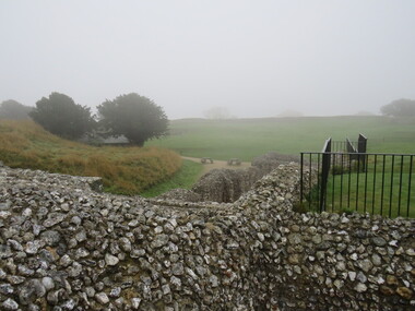
 Ballarat Heritage Services
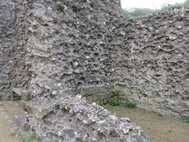
Photograph - Colour, Stonework, Old Sarum, England, English Heritage Site, 01 November 2016
... Stonework, Old Sarum, England, English Heritage Site...The nearer end of Mudge's line is marked by an inscribed stone beside the modern A345 at Old Sarum. ordnance survey, william mudge, jesse ramsden, william the conqueror, old sarum, saxon, 1086, england Stonework, Old Sarum, England, English Heritage Site Photograph - Colour ...William the Conqueror inherited Old Sarum from the last Saxon king of England. It was an ideal site for a royal castle. It was here in 1070 that William paid off his army after a long and bitter campaign in northern England. It was here in 1086 that he called together all the major landholders in England so they could swear allegiance to him. It was a crucial moment. The Domesday Book was being written, a threatened Viking invasion had only just been averted and William's eldest son was in armed rebellion. Old Sarum was an important place where this Norman king of England held power. In 1794 the Ordnance Survey set out to check the accuracy of the first mapping of Southern England, which had begun ten years earlier. From a point just below Old Sarum Lieutenant William Mudge laid out a base-line 36,574 feet (11,253 metres) long. From each end of the line the positions of distant places were plotted using a huge theodolite made in 1791 by Jesse Ramsden. The accuracy of the process, which was repeated all over England, depended on Jesse Ramsden's craftsmanship and on William Mudge's surveying skill in setting out this first base-line from Old Sarum. The nearer end of Mudge's line is marked by an inscribed stone beside the modern A345 at Old Sarum. ordnance survey, william mudge, jesse ramsden, william the conqueror, old sarum, saxon, 1086, england -
 Ballarat Heritage Services
Photograph - Colour, Stonework, Old Sarum, England, English Heritage Site, 01 November 2016
... Stonework, Old Sarum, England, English Heritage Site...The nearer end of Mudge's line is marked by an inscribed stone beside the modern A345 at Old Sarum. ordnance survey william mudge jesse ramsden william the conqueror old sarum saxon 1086 england Stonework, Old Sarum, England, English Heritage Site Photograph - Colour ...William the Conqueror inherited Old Sarum from the last Saxon king of England. It was an ideal site for a royal castle. It was here in 1070 that William paid off his army after a long and bitter campaign in northern England. It was here in 1086 that he called together all the major landholders in England so they could swear allegiance to him. It was a crucial moment. The Domesday Book was being written, a threatened Viking invasion had only just been averted and William's eldest son was in armed rebellion. Old Sarum was an important place where this Norman king of England held power. In 1794 the Ordnance Survey set out to check the accuracy of the first mapping of Southern England, which had begun ten years earlier. From a point just below Old Sarum Lieutenant William Mudge laid out a base-line 36,574 feet (11,253 metres) long. From each end of the line the positions of distant places were plotted using a huge theodolite made in 1791 by Jesse Ramsden. The accuracy of the process, which was repeated all over England, depended on Jesse Ramsden's craftsmanship and on William Mudge's surveying skill in setting out this first base-line from Old Sarum. The nearer end of Mudge's line is marked by an inscribed stone beside the modern A345 at Old Sarum. ordnance survey, william mudge, jesse ramsden, william the conqueror, old sarum, saxon, 1086, england -
 Ballarat Heritage Services
Photograph - Colour, Stonework, Old Sarum, England, English Heritage Site, 2016, 01 November 2016
... Stonework, Old Sarum, England, English Heritage Site, 2016...The nearer end of Mudge's line is marked by an inscribed stone beside the modern A345 at Old Sarum. ordnance survey, william mudge, jesse ramsden, william the conqueror, old sarum, saxon, 1086, england Stonework, Old Sarum, England, English Heritage Site, 2016 Photograph - Colour ...William the Conqueror inherited Old Sarum from the last Saxon king of England. It was an ideal site for a royal castle. It was here in 1070 that William paid off his army after a long and bitter campaign in northern England. It was here in 1086 that he called together all the major landholders in England so they could swear allegiance to him. It was a crucial moment. The Domesday Book was being written, a threatened Viking invasion had only just been averted and William's eldest son was in armed rebellion. Old Sarum was an important place where this Norman king of England held power. In 1794 the Ordnance Survey set out to check the accuracy of the first mapping of Southern England, which had begun ten years earlier. From a point just below Old Sarum Lieutenant William Mudge laid out a base-line 36,574 feet (11,253 metres) long. From each end of the line the positions of distant places were plotted using a huge theodolite made in 1791 by Jesse Ramsden. The accuracy of the process, which was repeated all over England, depended on Jesse Ramsden's craftsmanship and on William Mudge's surveying skill in setting out this first base-line from Old Sarum. The nearer end of Mudge's line is marked by an inscribed stone beside the modern A345 at Old Sarum. ordnance survey, william mudge, jesse ramsden, william the conqueror, old sarum, saxon, 1086, england -
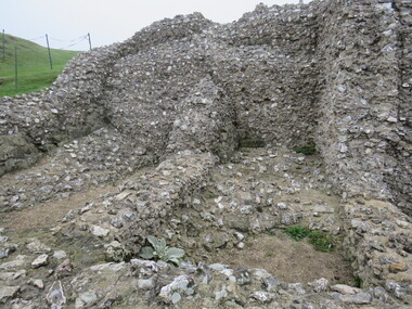
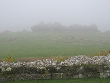
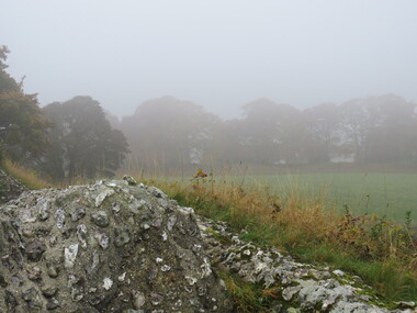
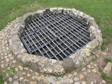 Ballarat Heritage Services
Photograph - Colour, Stonework and well, Old Sarum, England, English Heritage Site, 2016, 01 November 2016
... Stonework and well, Old Sarum, England, English Heritage Site, 2016...The nearer end of Mudge's line is marked by an inscribed stone beside the modern A345 at Old Sarum. ordnance survey, william mudge, jesse ramsden, william the conqueror, old sarum, saxon, 1086, england Stonework and well, Old Sarum, England, English Heritage Site, 2016 Photograph - Colour ...William the Conqueror inherited Old Sarum from the last Saxon king of England. It was an ideal site for a royal castle. It was here in 1070 that William paid off his army after a long and bitter campaign in northern England. It was here in 1086 that he called together all the major landholders in England so they could swear allegiance to him. It was a crucial moment. The Domesday Book was being written, a threatened Viking invasion had only just been averted and William's eldest son was in armed rebellion. Old Sarum was an important place where this Norman king of England held power. In 1794 the Ordnance Survey set out to check the accuracy of the first mapping of Southern England, which had begun ten years earlier. From a point just below Old Sarum Lieutenant William Mudge laid out a base-line 36,574 feet (11,253 metres) long. From each end of the line the positions of distant places were plotted using a huge theodolite made in 1791 by Jesse Ramsden. The accuracy of the process, which was repeated all over England, depended on Jesse Ramsden's craftsmanship and on William Mudge's surveying skill in setting out this first base-line from Old Sarum. The nearer end of Mudge's line is marked by an inscribed stone beside the modern A345 at Old Sarum. ordnance survey, william mudge, jesse ramsden, william the conqueror, old sarum, saxon, 1086, england -
 Ballarat Heritage Services
Photograph - Colour, Stonework, Old Sarum, England, English Heritage Site, 01 November 2016
... Stonework, Old Sarum, England, English Heritage Site...The nearer end of Mudge's line is marked by an inscribed stone beside the modern A345 at Old Sarum. ordnance survey, william mudge, jesse ramsden, william the conqueror, old sarum, saxon, 1086, england Stonework, Old Sarum, England, English Heritage Site Photograph - Colour ...William the Conqueror inherited Old Sarum from the last Saxon king of England. It was an ideal site for a royal castle. It was here in 1070 that William paid off his army after a long and bitter campaign in northern England. It was here in 1086 that he called together all the major landholders in England so they could swear allegiance to him. It was a crucial moment. The Domesday Book was being written, a threatened Viking invasion had only just been averted and William's eldest son was in armed rebellion. Old Sarum was an important place where this Norman king of England held power. In 1794 the Ordnance Survey set out to check the accuracy of the first mapping of Southern England, which had begun ten years earlier. From a point just below Old Sarum Lieutenant William Mudge laid out a base-line 36,574 feet (11,253 metres) long. From each end of the line the positions of distant places were plotted using a huge theodolite made in 1791 by Jesse Ramsden. The accuracy of the process, which was repeated all over England, depended on Jesse Ramsden's craftsmanship and on William Mudge's surveying skill in setting out this first base-line from Old Sarum. The nearer end of Mudge's line is marked by an inscribed stone beside the modern A345 at Old Sarum. ordnance survey, william mudge, jesse ramsden, william the conqueror, old sarum, saxon, 1086, england -
 Ballarat Heritage Services
Photograph - Colour, Stonework, Old Sarum, England, English Heritage Site, 2016, 01 November 2016
... Stonework, Old Sarum, England, English Heritage Site, 2016...The nearer end of Mudge's line is marked by an inscribed stone beside the modern A345 at Old Sarum. ordnance survey, william mudge, jesse ramsden, william the conqueror, old sarum, saxon, 1086, england Stonework, Old Sarum, England, English Heritage Site, 2016 Photograph - Colour ...William the Conqueror inherited Old Sarum from the last Saxon king of England. It was an ideal site for a royal castle. It was here in 1070 that William paid off his army after a long and bitter campaign in northern England. It was here in 1086 that he called together all the major landholders in England so they could swear allegiance to him. It was a crucial moment. The Domesday Book was being written, a threatened Viking invasion had only just been averted and William's eldest son was in armed rebellion. Old Sarum was an important place where this Norman king of England held power. In 1794 the Ordnance Survey set out to check the accuracy of the first mapping of Southern England, which had begun ten years earlier. From a point just below Old Sarum Lieutenant William Mudge laid out a base-line 36,574 feet (11,253 metres) long. From each end of the line the positions of distant places were plotted using a huge theodolite made in 1791 by Jesse Ramsden. The accuracy of the process, which was repeated all over England, depended on Jesse Ramsden's craftsmanship and on William Mudge's surveying skill in setting out this first base-line from Old Sarum. The nearer end of Mudge's line is marked by an inscribed stone beside the modern A345 at Old Sarum. ordnance survey, william mudge, jesse ramsden, william the conqueror, old sarum, saxon, 1086, england -
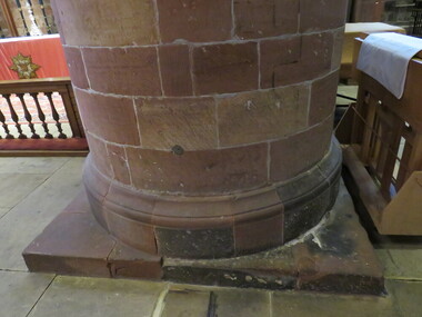
 Ballarat Heritage Services
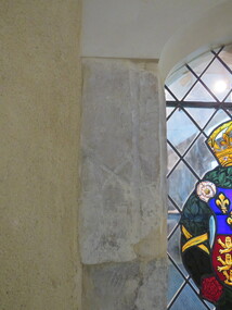
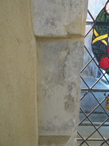
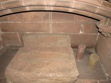
Photograph - Colour, Stonework, Carlisle Cathedral 27 October 2016
... Stonework, Carlisle Cathedral 27 October 2016...As canons rather than monks, they were freer to undertake pastoral and educational work. carlisle, cathedral, stonemasons, mason's marks Stonework, Carlisle Cathedral 27 October 2016 Photograph - Colour ...Carlisle and its cathedral. This cathedral church, which has stood on this site for over 800 years has a great story to tell. It is a story that can be traced back further still, to an even earlier church of the 7th century AD. Archaeological excavations on this site have taken the story back to Roman times. Today the dean and canons and other cathedral staff ensure that the worship of God remains the main work of this cathedral, while long-standing traditions of music, hospitality and education are also maintained. The story of this place is not so much about buildings, but about people. The buildings remain as evidence of the lives of people who lived and worked here and of what they believed and achieved. Until 1540 a community of Augustinian canons served the cathedral. They lived highly organized lives in monastic buildings suited to their needs. As canons rather than monks, they were freer to undertake pastoral and educational work. carlisle, cathedral, stonemasons, mason's marks -
 Ballarat Heritage Services
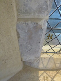
Photograph - Colour, Stonework, Carlisle Cathedral made 1500-1600
... Stonework, Carlisle Cathedral made 1500-1600...As canons rather than monks, they were freer to undertake pastoral and educational work. carlisle, cathedral, stonemasons, mason's marks Stonework, Carlisle Cathedral made 1500-1600 Photograph - Colour ...Carlisle and its cathedral. This cathedral church, which has stood on this site for over 800 years has a great story to tell. It is a story that can be traced back further still, to an even earlier church of the 7th century AD. Archaeological excavations on this site have taken the story back to Roman times. Today the dean and canons and other cathedral staff ensure that the worship of God remains the main work of this cathedral, while long-standing traditions of music, hospitality and education are also maintained. The story of this place is not so much about buildings, but about people. The buildings remain as evidence of the lives of people who lived and worked here and of what they believed and achieved. Until 1540 a community of Augustinian canons served the cathedral. They lived highly organized lives in monastic buildings suited to their needs. As canons rather than monks, they were freer to undertake pastoral and educational work. carlisle, cathedral, stonemasons, mason's marks -
 Ballarat Heritage Services
Photograph - Colour, Stonework, Carlisle Cathedral made 1500-1600
... Stonework, Carlisle Cathedral made 1500-1600...As canons rather than monks, they were freer to undertake pastoral and educational work. carlisle, cathedral, stonemasons, mason's marks Stonework, Carlisle Cathedral made 1500-1600 Photograph - Colour ...Carlisle and its cathedral. This cathedral church, which has stood on this site for over 800 years has a great story to tell. It is a story that can be traced back further still, to an even earlier church of the 7th century AD. Archaeological excavations on this site have taken the story back to Roman times. Today the dean and canons and other cathedral staff ensure that the worship of God remains the main work of this cathedral, while long-standing traditions of music, hospitality and education are also maintained. The story of this place is not so much about buildings, but about people. The buildings remain as evidence of the lives of people who lived and worked here and of what they believed and achieved. Until 1540 a community of Augustinian canons served the cathedral. They lived highly organized lives in monastic buildings suited to their needs. As canons rather than monks, they were freer to undertake pastoral and educational work. carlisle, cathedral, stonemasons, mason's marks