Showing 8 items matching "strathbogie ranges"
-
 Victoria Police Museum
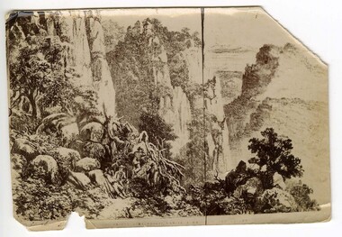
Sketch (Strathbogie Ranges)
... Sketch (Strathbogie Ranges)...The Saddle Strathbogie Ranges .......Victoria Police Museum 313 Spencer Street Docklands melbourne stringybark creek michael kennedy police murders kelly gang bushrangers glenrowan The Saddle Strathbogie Ranges .... Small photograph of an illustration showing a group of four men on a mountain side Sketch (Strathbogie Ranges) ...Small photograph of an illustration showing a group of four men on a mountain sideThe Saddle Strathbogie Ranges ....stringybark creek, michael kennedy, police murders, kelly gang, bushrangers, glenrowan -
 Victorian Aboriginal Corporation for Languages
Periodical, Australian Institute of Aboriginal and Torres Strait Islander Studies, Australian Aboriginal studies : journal of the Australian Institute of Aboriginal and Torres Strait Islander Studies, 2008
... ...Strathbogie Ranges...These relationships are not well understood in the Strathbogie Ranges of central Victoria, where few detailed analyses of stone artefact assemblages have been undertaken. ...These relationships are not well understood in the Strathbogie Ranges of central Victoria, where few detailed analyses of stone artefact assemblages have been undertaken. ...Mawul Rom Project: Openness, obligation and reconciliation Morgan Brigg (Universtiy of Queensland) and Anke Tonnaer (University of Aarhus, Denmark) Aboriginal Australian initiatives to restore balanced relationships with White Australians have recently become part of reconciliation efforts. This paper provides a contextualised report on one such initiative, the Mawul Rom crosscultural mediation project. Viewing Mawul Rom as a diplomatic venture in the lineage of adjustment and earlier Rom rituals raises questions about receptiveness, individual responsibility and the role of Indigenous ceremony in reconciliation efforts. Yolngu ceremonial leaders successfully draw participants into relationship and personally commit them to the tasks of cross-cultural advocacy and reconciliation. But Mawul Rom must also negotiate a paradox because emphasis on the cultural difference of ceremony risks increasing the very social distance that the ritual attempts to confront. Managing this tension will be a key challenge if Mawul Rom is to become an effective diplomatic mechanism for cross-cultural conflict resolution and reconciliation. Living in two camps: the strategies Goldfields Aboriginal people use to manage in the customary economy and the mainstream economy at the same time Howard Sercombe (Strathclyde University, Glasgow) The economic sustainability of Aboriginal households has been a matter of public concern across a range of contexts. This research, conducted in the Eastern Goldfields of Western Australia, shows how economically successful Aboriginal persons manage ?dual economic engagement?, or involvement in the customary economy and the mainstream economy at the same time. The two economies sometimes reinforce each other but are more often in conflict, and management of conflicting obligations requires high degrees of skill and innovation. As well as creating financially sustainable households, the participants contributed significantly to the health of their extended families and communities. The research also shows that many Aboriginal people, no matter what their material and personal resources, are conscious of how fragile and unpredictable their economic lives can be, and that involvement in the customary economy is a kind of mutual insurance to guarantee survival if times get tough. Indigenous population data for evaluation and performance measurement: A cautionary note Gaminiratne Wijesekere (Dept. of Families, Housing, Community Services and Indigenous Affairs, Canberra) I outline the status of population census counts for Indigenous peoples, identifying information on Indigenous births and deaths, and internal migration estimates. I comment on the ?experimental? Indigenous population projections and question the rationale for having two sets of projections. Program managers and evaluators need to be mindful of limitations of the data when using these projections for monitoring, evaluating and measuring Indigenous programs. Reaching out to a younger generation using a 3D computer game for storytelling: Vincent Serico?s legacy Theodor G Wyeld (Flinders University, Adeliade) and Brett Leavy (CyberDreaming Australia) Sadly, Vincent Serico (1949?2008), artist, activist and humanist, recently passed away. Born in southern Queensland in Wakka Wakka/Kabi Kabi Country (Carnarvon Gorge region) in 1949, Vincent was a member of the Stolen Generations. He was separated from his family by White administration at four years of age. He grew up on the Cherbourg Aboriginal Reserve in the 1950s, when the policies of segregation and assimilation were at their peak. Only returning to his Country in his early forties, Vincent started painting his stories and the stories that had been passed on to him about the region. These paintings manifest Vincent?s sanctity for tradition, storytelling, language, spirit and beliefs. A team of researchers was honoured and fortunate to have worked closely with Vincent to develop a 3D simulation of his Country using a 3D computer game toolkit. Embedded in this simulation of his Country, in the locations that their stories speak to, are some of Vincent?s important contemporary art works. They are accompanied by a narration of Vincent?s oral history about the places, people and events depicted. Vincent was deeply concerned about members of the younger generation around him ?losing their way? in modern times. In a similar vein, Brett Leavy (Kooma) sees the 3D game engine as an opportunity to engage the younger generation in its own cultural heritage in an activity that capitalises on a common pastime. Vincent was an enthusiastic advocate of this approach. Working in consultation with Vincent and the research team, CyberDreaming developed a simulation of Vincent?s Country for young Aboriginal and non-Aboriginal persons from the Carnarvon Gorge region to explore Vincent?s life stories of the region. The use of Vincent?s contemporary paintings as storyboards provides a traditional medium for the local people to interactively re-engage with traditional values. Called Serico?s World, it represents a legacy to his life?s works, joys and regrets. Here we discuss the background to this project and Vincent?s contribution. A singular beeswax representation of Namarrkon, the Lightning Man, from western Arnhem Land RG Gunn (La Trobe University) and RL Whear (Jawoyn Association) Samples from a beeswax representation of Namarrkon, the Lightning Man, from western Arnhem Land were analysed for radiocarbon and dated to be about 150 years old. An underlying beeswax figure was found to be approximately 1100 years old. The Dreaming Being Namarrkon is well known throughout Arnhem Land, although his sphere of activity is concentrated around the northern half of the Arnhem Land plateau. Namarrkon is well represented in rock-paintings in this area and continues to be well represented in contemporary canvas-paintings by artists from the broader plateau region. We conclude that representations of Namarrkon in both painted and beeswax forms appear to be parallel manifestations of the late Holocene regionalisation of Arnhem Land. ?Missing the point? or ?what to believe ? the theory or the data?: Rationales for the production of Kimberley points Kim Akerman (Moonah) In a recent article, Rodney Harrison presented an interesting view on the role glass Kimberley points played in the lives of the Aborigines who made and used them. Harrison employed ethnographic and historical data to argue that glass Kimberley points were not part of the normal suite of post-contact artefacts used primarily for hunting and fighting or Indigenous exchange purposes, but primarily were created to service a non-Indigenous market for aesthetically pleasing artefacts. Harrison asserted that this market determined the form that these points took. A critical analysis of the data does not substantiate either of these claims. Here I do not deal with Harrison?s theoretical material or arguments; I focus on the ethnographic and historical material that he has either omitted or failed to appreciate in developing his thesis and which, in turn, renders it invalid. The intensity of raw material utilisation as an indication of occupational history in surface stone artefact assemblages from the Strathbogie Ranges, central Victoria Justin Ian Shiner (La Trobe University, Bundoora) Stone artefact assemblages are a major source of information on past human?landscape relationships throughout much of Australia. These relationships are not well understood in the Strathbogie Ranges of central Victoria, where few detailed analyses of stone artefact assemblages have been undertaken. The purpose of this paper is to redress this situation through the analysis of two surface stone artefact assemblages recorded in early 2000 during a wider investigation of the region?s potential for postgraduate archaeological fieldwork. Analysis of raw material utilisation is used to assess the characteristics of the occupational histories of two locations with similar landscape settings. The analysis indicates variability in the intensity of raw material use between the assemblages, which suggests subtle differences in the occupational history of each location. The results of this work provide a direction for future stone artefact studies within this poorly understood region.document reproductions, maps, b&w photographs, colour photographskimberley, mawul rom project, 3d computer game, storytelling, vincent serico, beeswax, namarrkon, artefact assemblages, strathbogie ranges, groote eylandt, budd billy ii -
 Victorian Aboriginal Corporation for Languages
Book, Nigel Sinnott, Place-names of the Alexandra, Lake Eildon and Big River area of Victoria, 2003
... ...Strathbogie Ranges...Victorian Aboriginal Corporation for Languages 33 Saxon Street Brunswick melbourne place names Alexandra Lake Eildon Strathbogie Ranges Yea Marysville Healesville Maps, colour photographs Contains 2000 entries for the Alexandra area, giving a clearly detailed description of the site and source of the name. ...Contains 2000 entries for the Alexandra area, giving a clearly detailed description of the site and source of the name.Maps, colour photographsplace names, alexandra, lake eildon, strathbogie ranges, yea, marysville, healesville -
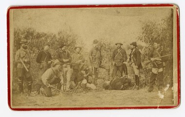
 Victoria Police Museum
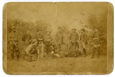
Photograph (ten men with rifles), 1879
... Superintendent Hare's search party taken just before they were about to start for the Strathbogie Ranges...Victoria Police Museum 313 Spencer Street Docklands melbourne kelly gang bushrangers search party francis augustus hare thomas lawless alfred john falkiner joseph ladd mayes john milne thomas hewitt kirkham william canny Superintendent Hare's search party taken just before they were about to start for the Strathbogie Ranges Black and white photograph showing a group of ten men with rifles in a staged bushland setting. ...Black and white photograph showing a group of ten men with rifles in a staged bushland setting. Eight are standing and two are crouching. Superintendent Hare's search party taken just before they were about to start for the Strathbogie Rangeskelly gang, bushrangers, search party, francis augustus hare, thomas lawless, alfred john falkiner, joseph ladd mayes, john milne, thomas hewitt kirkham, william canny -
 Victoria Police Museum
Carte de Visite (ten men with rifles)
... Image was taken just before the party set out in search for the Kelly Gang outlaws in the Strathbogie Ranges...Victoria Police Museum 313 Spencer Street Docklands melbourne Image was taken just before the party set out in search for the Kelly Gang outlaws in the Strathbogie Ranges Search party Police search party Kelly Gang Bushrangers Francis Augustus Hare Superintendent Hare Thomas Lawless Alfred John Falkiner Joseph Ladd Mayes John Milne Thomas Hewitt Kirkham William Canny Supt Hares party (written on rear in pencil) Small black and white photograph showing a group of ten men with rifles in a (staged) bushland setting. ...Image was taken just before the party set out in search for the Kelly Gang outlaws in the Strathbogie RangesSmall black and white photograph showing a group of ten men with rifles in a (staged) bushland setting. Eight are standing and two are crouched down on one leg.Supt Hares party (written on rear in pencil)search party, police search party, kelly gang, bushrangers, francis augustus hare, superintendent hare, thomas lawless, alfred john falkiner, joseph ladd mayes, john milne, thomas hewitt kirkham, william canny -
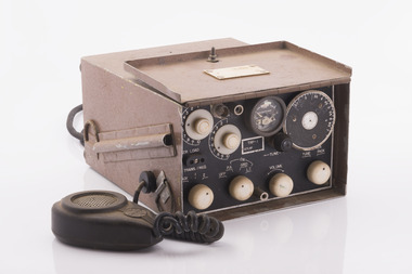 Department of Energy, Environment and Climate Action
Pye TRP-1, Transmitter-Receiver-Portable Radio, Pye Industries in Melbourne, circa 1950
... This radio was used in the Mt Wombat fire tower which overlooks the Strathbogie Ranges and surrounding farmland....This radio was used in the Mt Wombat fire tower which overlooks the Strathbogie Ranges and surrounding farmland. Radios Forests Commission Victoria (FCV) Portable Radio PYE TRP-1. ...After the 1939 bushfires, the Forests Commission invested heavily in a radically new communications network. After suffering some inevitable delays due to the War, radio VL3AA switched into full operation in October 1945 proudly beaming out 200 watts across the State. The communication systems were regarded at the time to be more technically advanced than the police and the military. Pye-Electronic Pty Ltd (which had taken over Radio Corporation after the war) decided to design a transceiver to replace the RC16B. Designated the TRP-1, it was considerably lighter and used less power than the earlier RC16B while offering similar or better performance. This radio was used in the Mt Wombat fire tower which overlooks the Strathbogie Ranges and surrounding farmland.Portable Radio PYE TRP-1. radios, forests commission victoria (fcv) -
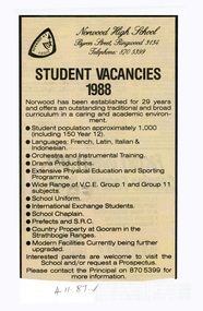 Ringwood and District Historical Society
Newspaper - Clipping, Norwood High School, Ringwood, Victoria
... . • Country Property at Gooram in the Strathbogie Ranges. • Modern Facilities Currently being further upgraded. .... • Country Property at Gooram in the Strathbogie Ranges. • Modern Facilities Currently being further upgraded. ...November 1987 advertisement inviting enrolment enquiries for the following year.Norwood has been established for 29 years and offers an outstanding traditional and broad curriculum in a caring and academic environment. • Student population approximately 1,000 (including 150 Year 12). • Languages: French, Latin, Italian & Indonesian. • Orchestra and Instrumental Training. • Drama Productions. • Extensive Physical Education and Sporting Programme. • Wide Range of V.C.E. Group 1 and Group 11 subjects. • School Uniform. • International Exchange Students. • School Chaplain. • Prefects and S.R.C. • Country Property at Gooram in the Strathbogie Ranges. • Modern Facilities Currently being further upgraded. Advertisement invites Interested parents to visit the School and/or request a Prospectus, and includes contact details for the Principal on 870 5399 for more information. -
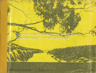 Eltham District Historical Society Inc
Book, Land Conservation Council, Report on the Melbourne Study Area, December 1973
... It is divided into four main sections: Introduction, Characteristics of environment, main forms of land use and description of 24 specific blocks in the study area which include Torquay, Brisbane Ranges, Werribee, Wombat, Loddon, Romsey, Puckapunyal, Strathbogie, Eildon, Disappointment, Break O'Day, Black Range, Cerberean, Upper Goulburn, Kinglake, Donna Buang, Upper Yarra, Thomson, Dandenongs, Bunyip-Latrobe, Shady Creek, Tyers, Westernport and Strzelecki. ...This report is one of a series describings the physical nature of the land and its environment, examines the likely forms of land use, and assesses the hazards associated with these uses. It is divided into four main sections: Introduction, Characteristics of environment, main forms of land use and description of 24 specific blocks in the study area which include Torquay, Brisbane Ranges, Werribee, Wombat, Loddon, Romsey, Puckapunyal, Strathbogie, Eildon, Disappointment, Break O'Day, Black Range, Cerberean, Upper Goulburn, Kinglake, Donna Buang, Upper Yarra, Thomson, Dandenongs, Bunyip-Latrobe, Shady Creek, Tyers, Westernport and Strzelecki. The Land Conservation Act 1970 established the Land Conservation Council whose functions is to "carry out investigations and make recommendations to the Minister with respect to the use of public land in order to provide for the balanced use of land in Victoria. This report sets out to describe and assess the natural resources of the public lands in the Melbourne area and provides a factual basis on which members of the community may base submissions to the [Land Conservation] Council of Victoria.444 pagesnon-fictionThis report is one of a series describings the physical nature of the land and its environment, examines the likely forms of land use, and assesses the hazards associated with these uses. It is divided into four main sections: Introduction, Characteristics of environment, main forms of land use and description of 24 specific blocks in the study area which include Torquay, Brisbane Ranges, Werribee, Wombat, Loddon, Romsey, Puckapunyal, Strathbogie, Eildon, Disappointment, Break O'Day, Black Range, Cerberean, Upper Goulburn, Kinglake, Donna Buang, Upper Yarra, Thomson, Dandenongs, Bunyip-Latrobe, Shady Creek, Tyers, Westernport and Strzelecki. The Land Conservation Act 1970 established the Land Conservation Council whose functions is to "carry out investigations and make recommendations to the Minister with respect to the use of public land in order to provide for the balanced use of land in Victoria. This report sets out to describe and assess the natural resources of the public lands in the Melbourne area and provides a factual basis on which members of the community may base submissions to the [Land Conservation] Council of Victoria.land use, kinglake, thomson valley, conservation, public lands