Showing 5403 items matching "street plan"
-
![Plan, Surveyor's Street Plan of Melbourne 1837 [copy], 1837_](/media/collectors/4f729f5697f83e03086015b8/items/534ccbc12162ef06c8d2cbf7/item-media/58afbfe2d0ce1616fcdf244b/item-fit-380x285.jpg?cb=6) Greensborough Historical Society
Greensborough Historical SocietyPlan, Surveyor's Street Plan of Melbourne 1837 [copy], 1837_
... Surveyor's Street Plan of Melbourne 1837 [copy]...melbourne street plan...Copy of Surveyor's Street Plan of Melbourne 1837. Donated by Patsy Coverdale and accompanied by brief details of her family connection to the map. ...Surveyor's Street Plan of Melbourne 1837 [copy] Plan ...Copy of Surveyor's Street Plan of Melbourne 1837. Donated by Patsy Coverdale and accompanied by brief details of her family connection to the map. Copies of plan available for sale from Greensborough Historical Society.Map of early Melbourne with connections to a current resident.Copy of plan, mounted on timber and framed.melbourne street plan, coverdaye, umpleby -
 Wonga Park Community Cottage History Group
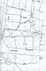
Plan - Location Plans, of the dams on the Arthur John Upton Reserve in Wonga Park, of the location of the Reserve and a street plan of the area
... of the dams on the Arthur John Upton Reserve in Wonga Park, of the location of the Reserve and a street plan of the area...Of the location of the Reserve and a street plan of the area...Of the location of the Reserve and a street plan of the area of the dams on the Arthur John Upton Reserve in Wonga Park, of the location of the Reserve and a street plan of the area Plan Location Plans ...Plans of the location of the dams on the Arthur John Upton Reserve in Wonga Park. Of the location of the Reserve and a street plan of the area -
 Federation University Historical Collection
Plan - Main Street Plan, John Carruthers, Plan of Main Street Ballarat done by J Carruthers 1858, 1858
... Main Street Plan...Plan of Main Street Ballarat done by J Carruthers 1858...long thin hand drawn plan of Main Street Ballarat on brown wax paper....Plan of Main Street Ballarat done by J Carruthers 1858 Plan Main Street Plan John Carruthers ...This is an Historical plan of Ballarat and gives us a look back in time.long thin hand drawn plan of Main Street Ballarat on brown wax paper.j carruthers, main st, main street, free trade hotel, eureka street, specimen hill road, humffray street, star hotel, old kaiser hotel, golden age hotel, royal mail hotel, john carruthers -
 Bendigo Historical Society Inc.
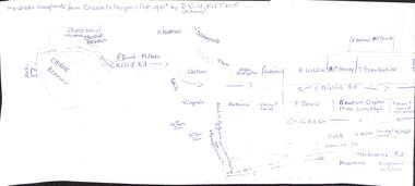
Map - Edith Perry Collection: Notes of properties in Kangaroo Flat from Crusoe Reservoir to Camp Street, and drafted plan
... Edith Perry Collection: Notes of properties in Kangaroo Flat from Crusoe Reservoir to Camp Street, and drafted plan....Hand drafted details/notes of businesses on High Street. Notes and plan not drawn to scale....Hand drafted details/notes of businesses on High Street. Notes and plan not drawn to scale. Map Edith Perry Collection: Notes of properties in Kangaroo Flat from Crusoe Reservoir to Camp Street, and drafted plan. ...Edith Perry Collection: Notes prepared covering the business properties in High Street Kangaroo Flat, between Crusoe reservoir and Camp Street. Hand drafted details/notes of businesses on High Street. Notes and plan not drawn to scale.kangaroo flat properties high street -
 Federation University Historical Collection
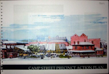
Booklet, Camp Street Precinct Action Plan, 10/1998
... Camp Street Precinct Action Plan...The camp Street Action Plan aimed to create a vibrant focus of community life, arts and culture in the heart of Ballarat. ...Barker Library (top floor) Mount Helen goldfields The camp Street Action Plan aimed to create a vibrant focus of community life, arts and culture in the heart of Ballarat. ...The camp Street Action Plan aimed to create a vibrant focus of community life, arts and culture in the heart of Ballarat. It included the relocation of the University of Ballarat Visual and Performing Arts from Mt Helen to the Camp Street precinct. Key sits were the Ballarat Post Office, former Ballarat Library, Victorian Business Centre, Police stations, Ballarat fine Art Gallery, field Street Car Parks. Rring bound booklet with clear plastic cover.arts academy, camp street precinct, alfred deakin place, former ballarat mining exchange, mining museum, art gallery of ballarat -
Box Hill Historical Society
Book, City of Box Hill, Prospect Street Development Plan - Draft, 1983
... Prospect Street Development Plan - Draft...Prospect Street Development Plan - Draft Book City of Box Hill ...This paper provides recommendations for the Prospect Street, Box Hill, area being developed as an "enterprise area" for larger office buildings. It takes into consideration traffic flow - both pedestrian and vehicular; types of land use control, i.e. permitted uses, discretionary uses and prohibited uses; and buildings suitable for offices. Maps.land use, town planning, prospect street, box hill, whitehorse road, nelson road, elgar road, traffic -
Port Melbourne Historical & Preservation Society
Plan - Street levels, c. 1862
... Drawn up to replace rescinded portions of street plan of March 1862....Plan of street levels...Port Melbourne Historical & Preservation Society Port Melbourne Town Hall 333 Bay Street Port Melbourne melbourne Drawn up to replace rescinded portions of street plan of March 1862. Engineering - Roads Streets Lanes and Footpaths Frederick William BULL Thomas SWALLOW Edward CLARK Town Clerks Details and signatures as below Plan of street levels Plan Street levels ...Drawn up to replace rescinded portions of street plan of March 1862.Plan of street levelsDetails and signatures as belowengineering - roads streets lanes and footpaths, frederick william bull, thomas swallow, edward clark, town clerks -
 Bendigo Historical Society Inc.
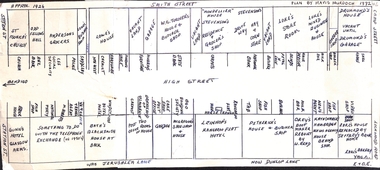
Map - Edith Perry Collection: Notes of properties in Kangaroo Flat High Street, between Station Street and Camp Street, and Architect's plan
... Edith Perry Collection: Notes of properties in Kangaroo Flat High Street, between Station Street and Camp Street, and Architect's plan...Edith Perry Collection: Notes prepared covering the business properties in High Street Kangaroo Flat, between Station Street and Camp Street; circa 1926. 1107014a - hand drafted notes over 12 pages prepared by Mavis Murdoch (nee Mitchell) 11070.14b - hand drafted plan on cardboard, made by Mavis Murdoch and prepared from the notes as above 11070.14c - Architect (unknown) plan detailing the property, hand drafted on film...Kangaroo Flat Properties High Street circa 1926 Edith Perry Collection: Notes prepared covering the business properties in High Street Kangaroo Flat, between Station Street and Camp Street; circa 1926. 1107014a - hand drafted notes over 12 pages prepared by Mavis Murdoch (nee Mitchell) 11070.14b - hand drafted plan on cardboard, made by Mavis Murdoch and prepared from the notes as above 11070.14c - Architect (unknown) plan detailing the property, hand drafted on film Map Edith Perry Collection: Notes of properties in Kangaroo Flat High Street, between Station Street and Camp Street, and Architect's plan ...Edith Perry Collection: Notes prepared covering the business properties in High Street Kangaroo Flat, between Station Street and Camp Street; circa 1926. 1107014a - hand drafted notes over 12 pages prepared by Mavis Murdoch (nee Mitchell) 11070.14b - hand drafted plan on cardboard, made by Mavis Murdoch and prepared from the notes as above 11070.14c - Architect (unknown) plan detailing the property, hand drafted on filmkangaroo flat properties high street circa 1926 -
Federation University Historical Collection
Book - Report, Lydiard Street Site Development Plan, School of Mines and Industries, Ballarat, 1977, 1977
... Lydiard Street Site Development Plan, School of Mines and Industries, Ballarat, 1977...street campus...g.j. harrison...Campus Plan...Lydiard Street Site Development Plan, School of Mines and Industries, Ballarat, 1977 Book Report ...The Ballarat School of Mines is a predecessor institution of Federation University Australia.Brown soft covered ring bound report of 20 pages. ballarat school of mines, lydiard street campus, g.j. harrison, campus plan, master plan, smb campus, ballarat school of mines campus -
University of Melbourne, Burnley Campus Archives
Plan, VCAH Burnley College, Swan Street Richmond - Site Plan 1:1000 Fire Services Survey, 1991
... VCAH Burnley College, Swan Street Richmond - Site Plan 1:1000 Fire Services Survey...University of Melbourne, Burnley Campus Archives 500 Yarra Boulevard Richmond melbourne vcah burnley fire safety Plan with Buildings named, External Hydrant Sources and Main Entry Points marked. Scale 1:1000. Dated January 1991. VCAH Burnley College, Swan Street ...Plan with Buildings named, External Hydrant Sources and Main Entry Points marked. Scale 1:1000. Dated January 1991.vcah, burnley, fire safety -
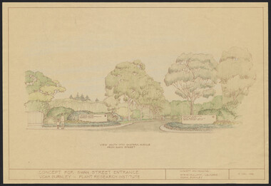 University of Melbourne, Burnley Campus Archives
Plan, Landscape Plan Swan Street Entrance. VCAH Burnley and Plant Research Institute, 1988-1998
... Landscape Plan Swan Street Entrance. VCAH Burnley and Plant Research Institute...Includes Plant Plan. 2 copies on tracing paper. 3 copies original on paper with some additional notation. (30 Project Eden, Swan Street, Richmond - Landscape Plan LA2 Project No 682 by Mark McWha Pty Ltd Nov 1997. ...Includes Plant Plan. 2 copies on tracing paper. 3 copies original on paper with some additional notation. (30 Project Eden, Swan Street, Richmond - Landscape Plan LA2 Project No 682 by Mark McWha Pty Ltd Nov 1997. ...(1) Concept and Drawing by Steve Mullany, Lec turer V.C.A.H. Burnley 9 Dec 1988. Handdrawn. 1 coloured, 2 copies and 4 tracing paper sketches. (2) Landscape Plan by Steve Mullany 3 Feb 1989. Handdrawn. Includes Plant Plan. 2 copies on tracing paper. 3 copies original on paper with some additional notation. (30 Project Eden, Swan Street, Richmond - Landscape Plan LA2 Project No 682 by Mark McWha Pty Ltd Nov 1997. Photocopy. Includes Irrigation and Plant Schedule. (4) Swan St Frontage Planting Scheme by P. Tulk for AMRAD. Coloured. 19/2/1998. -
Clunes Museum
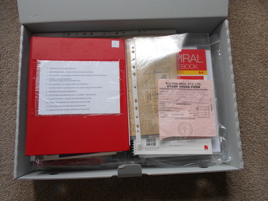
Booklet, Clunes Street Beautification Project
... ...street plan...Clunes Museum 36 Fraser Street enter building through Collins Place Clunes goldfields Proposal for town environment and social benefits beautification cheshire street plan Loosely bound A4 with clear cover contains proposal for Clunes beautification with street drawings, undated, unnumbered Clunes Street Beautification Project Booklet BOOKLET ...Loosely bound A4 with clear cover contains proposal for Clunes beautification with street drawings, undated, unnumberedbeautification, cheshire, street plan -
Port Melbourne Historical & Preservation Society
Plan - Proposed crossing, Rouse Street at Nott Street, George Kelly, Borough Surveyor, 27 Oct 1864
... Place of Proposed Crossing in Rouse Street (Corner Nott Street) Plan..., Borough Surveyor, Sandridge, 27-10-1864 Place of Proposed Crossing in Rouse Street (Corner Nott Street) Plan Plan Proposed crossing, Rouse Street at Nott Street George Kelly, Borough Surveyor ...Place of Proposed Crossing in Rouse Street (Corner Nott Street) PlanGeo. Kelly, Cr.(?), Borough Surveyor, Sandridge, 27-10-1864engineering - roads streets lanes and footpaths, george kelly -
University of Melbourne, Burnley Campus Archives
Plan, Michael Green, 46 Young Street Kew Garden Concept Plan, 2000
... 46 Young Street Kew Garden Concept Plan...University of Melbourne, Burnley Campus Archives 500 Yarra Boulevard Richmond melbourne michael green gardens kew Tracing paper plan by Michael Green dated December 2000. Scale 1:50 46 Young Street Kew Garden Concept Plan Plan Michael Green ...Tracing paper plan by Michael Green dated December 2000. Scale 1:50michael green, gardens, kew -
Whitehorse Historical Society Inc.
Document, Advance Blackburn!, c. 1900
... Circular letter and street plan regarding donations sought to fund a proposed extension of The Avenue to Blackburn Road....Circular letter and street plan regarding donations sought to fund a proposed extension of The Avenue to Blackburn Road. ...Circular letter and street plan regarding donations sought to fund a proposed extension of The Avenue to Blackburn Road.Circular letter and street plan regarding donations sought to fund a proposed extension of The Avenue to Blackburn Road.Circular letter and street plan regarding donations sought to fund a proposed extension of The Avenue to Blackburn Road.blackburn road blackburn, elmore, algernon john, williams, e. g., page, chas. d, the avenue, blackburn -
Lakes Entrance Historical Society
Map - Lakes Entrance
... Street plan of the area of Lakes Entrance showing North Arm, Whiters Street, Marine Parade and Bullock Island...Lakes Entrance Historical Society 4 Marine Parade Lakes Entrance gippsland Maps Township Islands Waterways Street plan of the area of Lakes Entrance showing North Arm, Whiters Street, Marine Parade and Bullock Island Map Lakes Entrance ...Street plan of the area of Lakes Entrance showing North Arm, Whiters Street, Marine Parade and Bullock Islandmaps, township, islands, waterways -
 Sunshine and District Historical Society Incorporated
Administrative record - City of Sunshine - Commissioner Mr Alexander Alex George Gillon Collection 1976 - 1982 - Report of committee meetings 12th December 1978, City of Sunshine, 12th December 1978
... Lease 2 - 4 Burton Crescent Subdivision of Land Fairbairn Road Proposed Rezoning of Land Laurel Street Planning Permit Bank extension Hampshire Road Planning Permit hairdressing Salon Hampshire Road Planning Permit factory Cromer Avenue Planning Permit Community Health Centre Andrea Street Planning Permit Educational Establishment Navigator Street Planning Permit Additions to existing church Ballarat Road Deer Park Planning Permit Entertainment Complex (Malibu grand Prix) Ballarat Road and Geelong Road Planning Permit Place of Assembly Hutchinson Street Construction of Justin Road Construction of laneway rear of Sydney Street between King Edward Avenue and Ridley street Planning Permit Flats Warrs Road and Fabian Court...Albans Hampshire Road Sunshine Cromer Avenue Sunshine North Andrea Street Navigator Street Ballarat Road Deer Park Geelong Road Braybrook Brooklyn Hutchinson Street Albion Justin Road Sydney Street King Edward Avenue Warrs Road Fabian Court Lease 2 - 4 Burton Crescent Subdivision of Land Fairbairn Road Proposed Rezoning of Land Laurel Street Planning Permit Bank extension Hampshire Road Planning Permit hairdressing Salon Hampshire Road Planning Permit factory Cromer Avenue Planning Permit Community Health Centre Andrea Street Planning Permit Educational Establishment Navigator Street Planning Permit Additions to existing church Ballarat Road Deer Park Planning Permit Entertainment Complex (Malibu grand Prix) Ballarat Road and Geelong Road Planning Permit Place of Assembly Hutchinson Street Construction of Justin Road Construction of laneway rear of Sydney Street between King Edward Avenue and Ridley street Planning Permit Flats Warrs Road and Fabian Court Foolscap sized document. ...Lease 2 - 4 Burton Crescent Subdivision of Land Fairbairn Road Proposed Rezoning of Land Laurel Street Planning Permit Bank extension Hampshire Road Planning Permit hairdressing Salon Hampshire Road Planning Permit factory Cromer Avenue Planning Permit Community Health Centre Andrea Street Planning Permit Educational Establishment Navigator Street Planning Permit Additions to existing church Ballarat Road Deer Park Planning Permit Entertainment Complex (Malibu grand Prix) Ballarat Road and Geelong Road Planning Permit Place of Assembly Hutchinson Street Construction of Justin Road Construction of laneway rear of Sydney Street between King Edward Avenue and Ridley street Planning Permit Flats Warrs Road and Fabian Court city of sunshine, alexander "alex" george gillon, burton crescent, maribyrnong, fairbairn road, sunshine west, laurel street, st. albans, hampshire road, sunshine, cromer avenue, sunshine north, andrea street, navigator street, ballarat road, deer park, geelong road, braybrook, brooklyn, hutchinson street, albion, justin road, sydney street, king edward avenue, warrs road, fabian court -
 Sunshine and District Historical Society Incorporated
Plan - Shire of Braybrook Private Street Construction Plans C1952
... Shire of Braybrook Private Street Construction Plans C1952...Shire of Braybrook Map Shire of Braybrook Private Street Construction Plans C1952 Large folder containing maps Plan Shire of Braybrook Private Street Construction Plans C1952 ...Shire of Braybrook Private Street Construction Plans C1952shire of braybrook, map -
 Kew Historical Society Inc
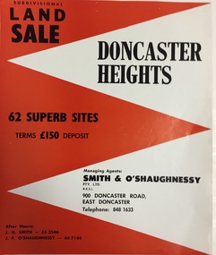
Plan - Subdivision Plan, Doncaster Heights
... The inside pages include a street plan with the numbered lots....The inside pages include a street plan with the numbered lots. Doncaster Heights Plan Subdivision Plan ...Real estate brochure produced for Smith & O'Shaughnessy of 900 Doncaster Road for the sale of the '65 superb sites' in the Doncaster Heights Estate. Streets with lots for sale include: Church Road, Norfolk Circuit, and Hampshire Road.Historic subdivision planFour-page colour real estate brochure issued for the sale of the Doncaster Heights Estate. The inside pages include a street plan with the numbered lots.subdivision plans - doncaster, doncaster heights estate -
 Eltham District Historical Society Inc
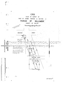
Document - Survey Plan, Country Roads Board, SP 6802, Eltham-Yarra Glen Road; Brougham St to Dalton St, 1958
... Street...Survey Plan...Jarrold Main Road Napoleon Street Survey Plan Neil Webster Collection Franco and Co A3 print, 3 pages and electronic PDF file SP 6802, Eltham-Yarra Glen Road; Brougham St to Dalton St Document Survey Plan Country Roads Board ...1958 C.R.B. Plan of Survey of Part of Crown Portion 12 Section 4 Parish of Nillumbik, County of Evelyn Eltham-Yarra Glen Road, Shire of Eltham Shows Surveyor field notes, property ownership and building type and construction.1958, eltham-yarra glen road, a.f. munday, bible street, brougham steet, country roads board, dalton street, eltham, j.p. & e.a. sanders, j.w. & e. m. graham, l.c. skipper, l.m. jarrold, main road, napoleon street, survey plan, neil webster collection, franco and co -
 Eltham District Historical Society Inc
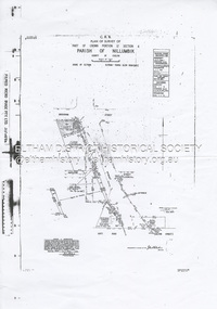
Document - Survey Plan, Country Roads Board et al, SP 12272A, Eltham-Yarra Glen Road; Brougham St to Dalton St, 1970-1976
... Street...Survey Plan...Skipper Main Road Eltham Map Maria Street Matcham Skipper Mobil Service Centre (Eltham) Mobil Service Station Napoleon Street Survey Plan White Cloud Cottage Country Roads Board A3 print, 2 pages SP 12272A, Eltham-Yarra Glen Road; Brougham St to Dalton St Document Survey Plan Country Roads Board John L. ...1970 C.R.B. Plan of Survey of Part of Crown Portion 12 Section 4 Parish of Nillumbik, County of Evelyn Eltham-Yarra Glen Road, Shire of Eltham Shows Surveyor field notes, property ownership and building type and construction. John L. Roberts, Licensed Surveyor as noted 4 June 1970 Amendments in black by John L. Roberts, L.S. 20-12-76 See also EDHS_05783 (1958)eltham-yarra glen road, 1970, 1976, a.f. munday, brougham street, dalton street, eltham, eltham clinic, g.t. & e.a. donnelly, jarrold cottage, l.m. jarrold, m.s.m. skipper, main road eltham, map, maria street, matcham skipper, mobil service centre (eltham), mobil service station, napoleon street, survey plan, white cloud cottage, country roads board -
 Eltham District Historical Society Inc
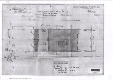
Document - Photocopy, Survey Fleld Notes of Part of Crown Portion 13, Section 4 at Eltham, Parish of Nillumbik, County of Evelyn, 1902-1903
... street...Survey Plan...Eltham District Historical Society Inc 728 Main Rd Eltham melbourne Main Road, Henry Street to Diamond Street; Silver Street to Bible Street Application No. 033777 1902 1903 Arthur Street Bible Street Bird street Diamond Creek (Creek) Diamond Street Eltham Eltham Railway Station henry street Main Road silver street Survey Plan Vine street Application 33777 Map A4 printouts, 7 pages Survey Fleld Notes of Part of Crown Portion 13, Section 4 at Eltham, Parish of Nillumbik, County of Evelyn Document Photocopy ...Main Road, Henry Street to Diamond Street; Silver Street to Bible Street Application No. 0337771902, 1903, arthur street, bible street, bird street, diamond creek (creek), diamond street, eltham, eltham railway station, henry street, main road, silver street, survey plan, vine street, application 33777, map -
 Eltham District Historical Society Inc
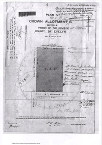
Document - Photocopy, Survey Fleld Notes of Part of Crown Portion 12, Section 4 at Eltham, Parish of Nillumbik, County of Evelyn, 12 October 1910
... Street...Survey Plan...Arndt, Licensed Surveyor, 12 August 1910 Application 38858 Bible Street Eltham John Street Main Road Map Pitt Street Survey Plan A4 printouts, 2 pages Survey Fleld Notes of Part of Crown Portion 12, Section 4 at Eltham, Parish of Nillumbik, County of Evelyn Document Photocopy ...Portion of land bounded by: Main Road, John Street, Bible Street, Pitt Street Application 38858 K. Arndt, Licensed Surveyor, 12 August 1910application 38858, bible street, eltham, john street, main road, map, pitt street, survey plan -
 Bendigo Historical Society Inc.
Document - BHS ADMINISTRATION COLLECTION: BRAC FLOOR PLAN, 2008 - 2010
... Street...Floor Plan...Floor plan of the Bendigo Regional Archive Centre 84 - 86 Nolan Street Bendigo....Bendigo Historical Society Nolan Street Floor Plan BRAC Floor plan of the Bendigo Regional Archive Centre 84 - 86 Nolan Street Bendigo. ...Floor plan of the Bendigo Regional Archive Centre 84 - 86 Nolan Street Bendigo.bendigo historical society, nolan street, floor plan, brac -
 Federation University Historical Collection
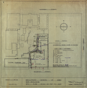
Plan - Plans, Ballarat School of Mines New Workshops, 1944, 17/11/1944
... street...buildings...plan...Plans (dyeline) for new building along the Ballarat School of Mines Albert Street frontage .1) Ballarat School of Mines New Workshops .2) as above Scale 1:480 WGS 84 37 degrees 33 feet 54 inches south 143 degrees 50 feet 30 inches east...Barker this was Metal Fabrication. ballarat school of mines metal fabrication albert street buildings plan heat engines room model mine blacksmiths shop blacksmithing carpenters shop engineering shope percy everett Sheet No 3 F.G.B. ...This building has been demolished to make way for new buildings along Albert Street. According to E.J. Barker this was Metal Fabrication.Plans (dyeline) for new building along the Ballarat School of Mines Albert Street frontage .1) Ballarat School of Mines New Workshops .2) as above Scale 1:480 WGS 84 37 degrees 33 feet 54 inches south 143 degrees 50 feet 30 inches eastSheet No 3 F.G.B.ballarat school of mines, metal fabrication, albert street, buildings, plan, heat engines room, model mine, blacksmiths shop, blacksmithing, carpenters shop, engineering shope, percy everett -
 Federation University Historical Collection
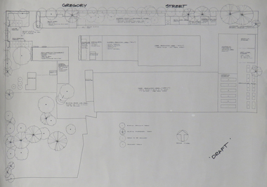
Plan, Ballarat School of Mines Horticulture Centre, Gregory St, Ballarat
... street...architectural plan...Plan for the Gregory Street Horticulture Centre....ballarat school of mines horticulture school of horticulture horticulture building gregory street architectural plan Plan for the Gregory Street Horticulture Centre. ...Plan for the Gregory Street Horticulture Centre.ballarat school of mines, horticulture, school of horticulture, horticulture building, gregory street, architectural plan -
 Federation University Historical Collection
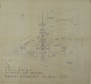
Plan, Ballarat School of Mines Development Plan, 1947, 09/12/1947
... plan...former ballarat gaol...former ballarat court house...lydiard street...Plan of the Ballarat School of Mines Lydiard Street Campus showing existing buildings, proposed demolition of all gaol buildings and court house. ...The Ballarat School of Mines was future planning before the proposed division of the tertiary division (Mt Helen Campus). ballarat school of mines development plan former ballarat gaol former ballarat court house lydiard street master plan campus plan Ballarat School of Mines Campus Plan of the Ballarat School of Mines Lydiard Street Campus showing existing buildings, proposed demolition of all gaol buildings and court house. ...The Ballarat School of Mines was future planning before the proposed division of the tertiary division (Mt Helen Campus).Plan of the Ballarat School of Mines Lydiard Street Campus showing existing buildings, proposed demolition of all gaol buildings and court house. ballarat school of mines, development plan, former ballarat gaol, former ballarat court house, lydiard street, master plan, campus plan, ballarat school of mines campus -
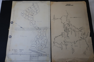 Kiewa Valley Historical Society
Maps - Bogong High Plains & Mt Beauty Township
... Titled: High Plains Access Tracks & Roads 2. Mt Beauty Street Plan by SECV with Section Nos. and house numbers...Titled: High Plains Access Tracks & Roads 2. Mt Beauty Street Plan by SECV with Section Nos. and house numbers Maps - Bogong High Plains & Mt Beauty Township ...The SECV continually updated their mapsDuring the development of the KHES the SECV had to continually update their mapsBoth Foolscap 1. Titled: High Plains Access Tracks & Roads 2. Mt Beauty Street Plan by SECV with Section Nos. and house numbersBoth have sticky tape marks on their back.khes maps -
Port Melbourne Historical & Preservation Society
Plan, Bay Street, C. 1990
... A proposed plan for the development of Bay Street, Port Melbourne. The Street plan shows suggestions for tree planting, verandah changes, proposed open space & building use....Bay Street Plan ...A proposed plan for the development of Bay Street, Port Melbourne. The Street plan shows suggestions for tree planting, verandah changes, proposed open space & building use.bay street, built environment - commercial -
Port Melbourne Historical & Preservation Society
Plan, Bay Street Site Analysis, C. 1990
... A site analysis plan for the development of Bay Street, Port Melbourne. The Street plan shows suggestions for tree planting, verandah changes, proposed open space & building use....Bay Street Site Analysis Plan ...A site analysis plan for the development of Bay Street, Port Melbourne. The Street plan shows suggestions for tree planting, verandah changes, proposed open space & building use.bay street, built environment - commercial