Showing 4 items matching "strzelecki ranges"
-
 Marysville & District Historical Society
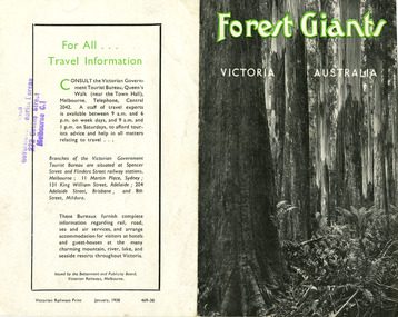
Ephemera (Item) - Information brochure, Victorian Government Tourist Bureau, Forest Giants Victoria Australia, 01-1938
... ...strzelecki ranges...An information brochure on where to see tall trees, Forest Giants, in Victoria, including Marysville, that was published in January, 1938. victoria australia victorian government tourist bureau betterment and publicity board victorian railways white mountain ash red mountain ash messmate blue gum mountain ash cumberland valley marysville mount monda healesville acheron way alpine highway omeo baw baws strzelecki ranges otway ranges warburton yarra junction noojee bulga and tarra valley park yarram turton's pass otway forest beech forest apollo bay information brochure brochure Victorian Railways Print January, 1938 469-38 Stamp of Victorian/ Government Tourist Bureau/ 272 Collins Street/ Melbourne C.1 An information brochure on where to see tall trees, Forest Giants, in Victoria, including Marysville, that was published in January, 1938. ...An information brochure on where to see tall trees, Forest Giants, in Victoria, including Marysville, that was published in January, 1938.An information brochure on where to see tall trees, Forest Giants, in Victoria, including Marysville, that was published in January, 1938.Victorian Railways Print January, 1938 469-38 Stamp of Victorian/ Government Tourist Bureau/ 272 Collins Street/ Melbourne C.1victoria, australia, victorian government tourist bureau, betterment and publicity board, victorian railways, white mountain ash, red mountain ash, messmate, blue gum, mountain ash, cumberland valley, marysville, mount monda, healesville, acheron way, alpine highway, omeo, baw baws, strzelecki ranges, otway ranges, warburton, yarra junction, noojee, bulga and tarra valley park, yarram, turton's pass, otway forest, beech forest, apollo bay, information brochure, brochure -
 Lakes Entrance Historical Society
Book, Land Conservation Council Victoria South Gippsland Area District 2, 1980
... Report describing and assessing the natural resources of the public land in the South Gippsland (Victoria) Study Area 2, comprising the Latrobe Valley, Strzelecki Range, South Gippsland coastal plains and all of Wilson's Promontory. ...Lakes Entrance Historical Society 4 Marine Parade Lakes Entrance gippsland Gippsland Topography Natural History Vegetation Ruth Clark Report describing and assessing the natural resources of the public land in the South Gippsland (Victoria) Study Area 2, comprising the Latrobe Valley, Strzelecki Range, South Gippsland coastal plains and all of Wilson's Promontory. ...Report describing and assessing the natural resources of the public land in the South Gippsland (Victoria) Study Area 2, comprising the Latrobe Valley, Strzelecki Range, South Gippsland coastal plains and all of Wilson's Promontory. Ruth Clarkgippsland, topography, natural history, vegetation -
 Eltham District Historical Society Inc
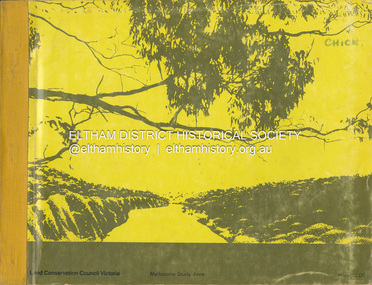
Book, Land Conservation Council, Report on the Melbourne Study Area, December 1973
... It is divided into four main sections: Introduction, Characteristics of environment, main forms of land use and description of 24 specific blocks in the study area which include Torquay, Brisbane Ranges, Werribee, Wombat, Loddon, Romsey, Puckapunyal, Strathbogie, Eildon, Disappointment, Break O'Day, Black Range, Cerberean, Upper Goulburn, Kinglake, Donna Buang, Upper Yarra, Thomson, Dandenongs, Bunyip-Latrobe, Shady Creek, Tyers, Westernport and Strzelecki. ...This report is one of a series describings the physical nature of the land and its environment, examines the likely forms of land use, and assesses the hazards associated with these uses. It is divided into four main sections: Introduction, Characteristics of environment, main forms of land use and description of 24 specific blocks in the study area which include Torquay, Brisbane Ranges, Werribee, Wombat, Loddon, Romsey, Puckapunyal, Strathbogie, Eildon, Disappointment, Break O'Day, Black Range, Cerberean, Upper Goulburn, Kinglake, Donna Buang, Upper Yarra, Thomson, Dandenongs, Bunyip-Latrobe, Shady Creek, Tyers, Westernport and Strzelecki. The Land Conservation Act 1970 established the Land Conservation Council whose functions is to "carry out investigations and make recommendations to the Minister with respect to the use of public land in order to provide for the balanced use of land in Victoria. This report sets out to describe and assess the natural resources of the public lands in the Melbourne area and provides a factual basis on which members of the community may base submissions to the [Land Conservation] Council of Victoria.444 pagesnon-fictionThis report is one of a series describings the physical nature of the land and its environment, examines the likely forms of land use, and assesses the hazards associated with these uses. It is divided into four main sections: Introduction, Characteristics of environment, main forms of land use and description of 24 specific blocks in the study area which include Torquay, Brisbane Ranges, Werribee, Wombat, Loddon, Romsey, Puckapunyal, Strathbogie, Eildon, Disappointment, Break O'Day, Black Range, Cerberean, Upper Goulburn, Kinglake, Donna Buang, Upper Yarra, Thomson, Dandenongs, Bunyip-Latrobe, Shady Creek, Tyers, Westernport and Strzelecki. The Land Conservation Act 1970 established the Land Conservation Council whose functions is to "carry out investigations and make recommendations to the Minister with respect to the use of public land in order to provide for the balanced use of land in Victoria. This report sets out to describe and assess the natural resources of the public lands in the Melbourne area and provides a factual basis on which members of the community may base submissions to the [Land Conservation] Council of Victoria.land use, kinglake, thomson valley, conservation, public lands -
 Victorian Aboriginal Corporation for Languages
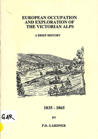
Book, P D Gardner, European occupation and exploration of the Victorian Alps : a brief history, 1835-1865, 1996
... Strzelecki...Gibbo Range...Victorian Aboriginal Corporation for Languages 33 Saxon Street Brunswick melbourne Ngarigo Jaitmathang Ngunawal Kosciusko Djilamatang Charlie Tarra Strzelecki Gibbo Range Omeo Jemmy Gibber E W Bayliss Matooka Matoka Monaro Maps, b&w illustrations European occupation and exploration of the Victorian Alps : a brief history, 1835-1865 Book P D Gardner ...Maps, b&w illustrationsngarigo, jaitmathang, ngunawal, kosciusko, djilamatang, charlie tarra, strzelecki, gibbo range, omeo, jemmy gibber, e w bayliss, matooka, matoka, monaro