Port Melbourne Historical & Preservation Society
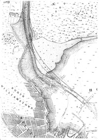
Photograph - Stumpy Rock at mouth of Yarra River, 1878
... ...Stumpy Rocks...The map's description "stumpy rocks" refers to a shallow basalt reef barrier which was located at the natural mouth of the Yarra River. ...The map's description "stumpy rocks" refers to a shallow basalt reef barrier which was located at the natural mouth of the Yarra River. ...
The map's description "stumpy rocks" refers to a shallow basalt reef barrier which was located at the natural mouth of the Yarra River. It was first observed and mapped by New South Wales Surveyor-General Charles Grimes during his February 1803 exploration of Port Phillip Bay. This basalt reef restricted maritime access to the Yarra River and was a cause of many upstream flood events. This map has the year 1878 inscribed. During the 1880's the reef was removed by blasting and was part of the larger project of straightening the Yarra River which included the creation of the Coode Canal.Digital black and white image of a map.built environment, yarra river, stumpy rocks, charles grimes