Showing 2 items matching "subdivision plans - emerald"
-
 Kew Historical Society Inc
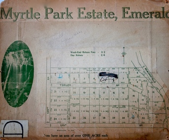
Plan - Subdivision Plan, Myrtle Park Estate, Emerald, 1915
... subdivision plans - emerald...This subdivision plan for the ‘Myrtle Park Estate’ relates to land sales in Emerald, Victoria, rather than to the subdivision of the same name in East Kew (1913-16). ...Kew Historical Society Inc Kew Court House 188 High Street Kew melbourne subdivision plans - emerald myrtle park estate Torley Road -- Emerald (Vic.) ...This subdivision plan for the ‘Myrtle Park Estate’ relates to land sales in Emerald, Victoria, rather than to the subdivision of the same name in East Kew (1913-16). The subdivision in Emerald included 32 one-acre lots facing Torley Road, Government Road (now Rawhiti and Wong Hee Roads) Beaconsfield Road (now Old Beaconsfield Road). On the plan, an unnamed creek flows through allotments 8-12 on the east side of the Estate. The photograph of a waterfall and the advertised price of Day Return and Weekend Return Fares provide an indication of who the prospective purchasers were likely to be.subdivision plans - emerald, myrtle park estate, torley road -- emerald (vic.) -
 Ringwood and District Historical Society
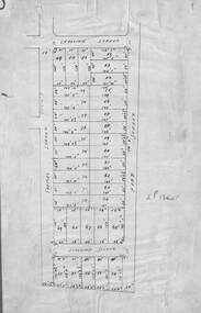
Map, Subdivision Plan of residential allotments in Caroline Street, Thomas Street, Emerald Street and Ford Street, Ringwood, Victoria - (Undated, circa 1930)
... Subdivision Plan of residential allotments in Caroline Street, Thomas Street, Emerald Street and Ford Street, Ringwood, Victoria - (Undated, circa 1930)....Subdivision Plan of residential allotments in Caroline Street, Thomas Street, Emerald Street and Ford Street, Ringwood, Victoria - (Undated, circa 1930). ...Map of residential allotments on blue cardboard backing.Handwritten title reference notation LP13641.