Showing 45 items matching "subdivision plans - greensborough"
-
 Greensborough Historical Society
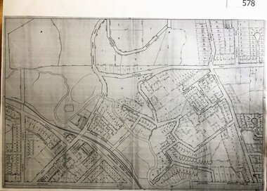
Map, City of Heidelberg, Subdivision plan of Greensborough, 1965c
... Subdivision plan of Greensborough...Subdivision plan of Greensborough including Briar Hill and Greenhills. ...Copies of subdivision plan for Greensborough...Greensborough Historical Society 34A Glenauburn Road Lower Plenty Lower Plenty melbourne Subdivision plan of Greensborough including Briar Hill and Greenhills. ...Subdivision plan of Greensborough including Briar Hill and Greenhills. Supplied by Bill Cecil whose parents owned the Greensborough Post Office and it is assumed that these maps were used by Bill (who delivered the post on horseback) to keep up to date with the growing number of new streets and housing in Greensborough.Copies of subdivision plan for Greensboroughgreensborough, briar hill, greenhills -
 Greensborough Historical Society
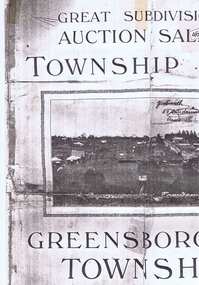
Plan, Greensborough Township Estate, 01/09/1923
... subdivision plans...greensborough...Auction 1 September 1923 subdivision plans greensborough township estate scotland family Photocopy, double-sided Greensborough Township Estate Plan J.C.Jessop ...Sub-division into 129 lots of land belonging to the Scotland Family, bounded by William Street, Eliza Street, James (Jessop) Street and south of Lorimer Street. Auction 1 September 1923Photocopy, double-sidedsubdivision plans, greensborough township estate, scotland family -
 Greensborough Historical Society
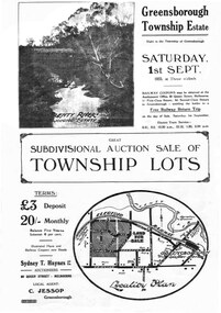
Plan - Digital Image, Greensborough Township Estate, 01/09/1923
... subdivision plans...greensborough...Auction 1 September 1923 subdivision plans greensborough township estate scotland family Digital copy of plan. ...Sub-division into 129 lots of land belonging to the Scotland Family, bounded by William Street, Eliza Street, James (Jessop) Street and south of Lorimer Street. Auction 1 September 1923Digital copy of plan. Has been digitally corrected from damaged original.subdivision plans, greensborough township estate, scotland family -
 Kew Historical Society Inc
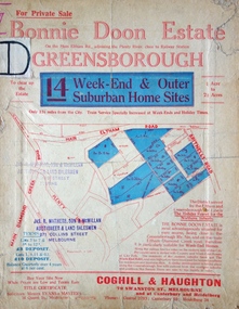
Plan - Subdivision Plan, Bonnie Doon Estate, c.1908
... ...Subdivision Plans - Greensborough...The subdivision advertised as the Bonnie Doon Estate in Greensborough was first advertised in 1908. At that stage, the new subdivision included 15 allotments of between one and four acres. By the time the subdivision plan...subdivision plans are historically significant examples of the growth of urban Melbourne from the beginning of the 20th Century up until the 1980s. A number of the plans are double-sided and often include a photograph on the reverse. A number of the latter are by noted photographers such as J.E. Barnes. Bonnie Doona Estate Subdivision Plans - Greensborough ...Pru Sanderson, in her groundbreaking ‘City of Kew Urban Conservation Study : Volume 2 - Development History’ (1988), summarised the periods of urban development and subdivisions of land in Kew. The periods that she identified included 1845-1880, 1880-1893, 1893-1921, 1921-1933, 1933-1943, and Post-War Development. These periods were selected as they represented periods of rapid growth or decline in urban development. An obvious starting point for Sanderson’s groupings involved population growth and the associated economic cycles. These cycles also highlighted urban expansion onto land that was predominantly rural, although in other cases it represented the decline and breakup of large estates. A number of the plans in the Kew Historical Society’s collection can also be found in other collections, such as those of the State Library of Victoria and the Boroondara Library Service. A number are however unique to the collection.The Kew Historical Society collection includes almost 100 subdivision plans pertaining to suburbs of the City of Melbourne. Most of these are of Kew, Kew East or Studley Park, although a smaller number are plans of Camberwell, Deepdene, Balwyn and Hawthorn. It is believed that the majority of the plans were gifted to the Society by persons connected with the real estate firm - J. R. Mathers and McMillan, 136 Cotham Road, Kew. The Plans in the collection are rarely in pristine form, being working plans on which the agent would write notes and record lots sold and the prices of these. The subdivision plans are historically significant examples of the growth of urban Melbourne from the beginning of the 20th Century up until the 1980s. A number of the plans are double-sided and often include a photograph on the reverse. A number of the latter are by noted photographers such as J.E. Barnes.The subdivision advertised as the Bonnie Doon Estate in Greensborough was first advertised in 1908. At that stage, the new subdivision included 15 allotments of between one and four acres. By the time the subdivision plan in the Kew Collection was created, only 12 lots of between ¾ and 2½ acres remained. Both the State Library and Kew plans emphasise the distance to the city being 13½ miles, which could be reached by train on weekdays and weekends. Unusually, the plan describes the suitability of lots as locations for ‘Week-end Homes’. Correspondingly, the train line is described as ‘The Holiday Resort for the Northern Suburbs’.bonnie doona estate, subdivision plans - greensborough -
 Greensborough Historical Society
Planning Document, John Taylor & Assoc, Subdivision Plan # 541, Somerleigh Crescent and Rainham Close, Greenhills, 21/06/1971
... subdivision plans...somerleigh crescent greensborough...An example of hard copy subdivision plans from the Greensborough area. Mainly from the Shire of Diamond Valley era (1964-1994). subdivision plans somerleigh crescent greensborough rainham close greensborough Stamped and handwritten Council permissions, dates and other details. ...Plan of Subdivision at Somerleigh Crescent and Rainham Close, Greenhills.An example of hard copy subdivision plans from the Greensborough area. Mainly from the Shire of Diamond Valley era (1964-1994).Plan (2 sheets) mounted on heavy card.Stamped and handwritten Council permissions, dates and other details.subdivision plans, somerleigh crescent greensborough, rainham close greensborough -
 Greensborough Historical Society
Poster - Planning Document, City of Heidelberg, Subdivision Plan # G313, Corner Main and Grimshaw Streets, Greensborough, 08/03/1960
... Subdivision Plan # G313, Corner Main and Grimshaw Streets, Greensborough....subdivision plans...main street greensborough...Plan of Subdivision at corner of Main and Grimshaw Streets, Greensborough....An example of hard copy subdivision plans from the Greensborough area. Mainly from the Shire of Diamond Valley era (1964-1994). subdivision plans main street greensborough grimshaw street greensborough Stamped and handwritten Council permissions, dates and other details. ...Plan of Subdivision at corner of Main and Grimshaw Streets, Greensborough.An example of hard copy subdivision plans from the Greensborough area. Mainly from the Shire of Diamond Valley era (1964-1994).Plan (2 sheets) mounted on heavy card.Stamped and handwritten Council permissions, dates and other details.subdivision plans, main street greensborough, grimshaw street greensborough -
![Planning Document, Plan of proposed subdivision of land in Greensborough [Map shows Scotland house], 01/04/1971](/media/collectors/4f729f5697f83e03086015b8/items/5982a68921ea6b1420e4e560/item-media/59916fb521ea681094908d7a/item-fit-380x285.jpg?cb=6) Greensborough Historical Society
Greensborough Historical SocietyPlanning Document, Plan of proposed subdivision of land in Greensborough [Map shows Scotland house], 01/04/1971
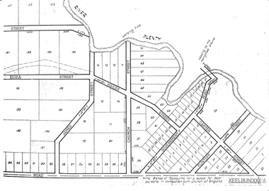
... Plan of proposed subdivision of land in Greensborough [Map shows Scotland house]...Part of plan (68G) of proposed subdivision of Greensborough, part of Crown Portion 18, Parish pf Keelbundora. ...Plan of proposed subdivision of land in Greensborough [Map shows Scotland house] Planning Document ...This subdivision of Greensborough shows the home of John Scotland (died 1888) and surrounding area bounded by Hailes, William, Lorimer, and Jessop Streets.Photocopy of plan, 2 pages.Part of plan (68G) of proposed subdivision of Greensborough, part of Crown Portion 18, Parish pf Keelbundora. Scale: 132 ft. to an inchjohn scotland, hailes street greensborough, william street greensborough, lorimer street greensborough, jessop street greensborough -
 Greensborough Historical Society
Map, Green's subdivision of Greensborough, 1860c
... Greensborough Historical Society 34A Glenauburn Road Lower Plenty Lower Plenty melbourne This map shows the original subdivision of Greensborough by Edward Bernard Green. Some street names are different to today. This map shows the plan on which the town of Greensborough was based. edward bernard green greensborough Copy of early map showing subdivision of Greensborough. ...This map shows the original subdivision of Greensborough by Edward Bernard Green. Some street names are different to today. This map shows the plan on which the town of Greensborough was based.Copy of early map showing subdivision of Greensborough. Black ink on white paper.edward bernard green, greensborough -
 Greensborough Historical Society
Newspaper Clipping, Subdivision tax set to bite, 13/09/2017
... Greensborough Historical Society 34A Glenauburn Road Lower Plenty Lower Plenty melbourne Mum and dad developers face being slugged with an extra tax to subdivide their properties. tax subdivision plans land development banyule city council News article 1 page, black text. ...Mum and dad developers face being slugged with an extra tax to subdivide their properties.News article 1 page, black text.tax, subdivision plans, land development, banyule city council -
 Greensborough Historical Society
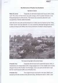
Article, Norm Colvin, My memories of Poulter Ave residents, by Norm Colvin, 28/07/2016
... Greensborough Historical Society 34A Glenauburn Road Lower Plenty Lower Plenty melbourne Details of the development and occupation of sites in Poulter Avenue and Bicton Street Greensborough, compiled by resident Norm Colvin. poulter avenue greensborough bicton street greensborough 12 pages, text, black and white photographs and colour subdivision plan. ...Details of the development and occupation of sites in Poulter Avenue and Bicton Street Greensborough, compiled by resident Norm Colvin.12 pages, text, black and white photographs and colour subdivision plan.poulter avenue greensborough, bicton street greensborough -
 Greensborough Historical Society
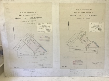
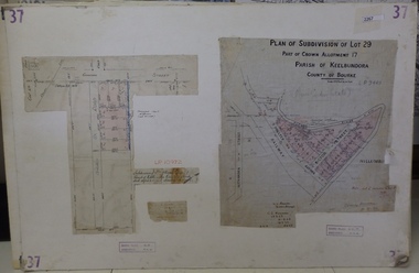
Planning Document, Subdivision Plan # 37. Poulter Avenue and Bicton Street; and, Adeline Street and Grimshaw Street Greensborough, 1971_
... Subdivision Plan # 37. Poulter Avenue and Bicton Street; and, Adeline Street and Grimshaw Street Greensborough...An example of hard copy subdivision plans from the Greensborough area. Mainly from the Shire of Diamond Valley era (1964-1994). subdivision plans grimshaw street poulter avenue adeline street Plan (2 sheets) mounted on heavy card. ...Plan of subdivision Lot 29, Part of Crown Allotment, Parish of Keelbundoora, County of Bourke. Poulter Avenue and Bicton Street; and, Adeline Street and Grimshaw Street.An example of hard copy subdivision plans from the Greensborough area. Mainly from the Shire of Diamond Valley era (1964-1994).Plan (2 sheets) mounted on heavy card. subdivision plans, grimshaw street, poulter avenue, adeline street -
 Greensborough Historical Society
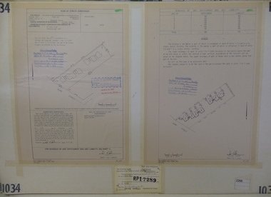
Planning Document, Subdivision Plan #1034. 50 Hume Street, 03/02/1982
... Plan of Strata Subdivision at 50 Hume Street Greensborough for 7 units....An example of hard copy subdivision plans from the Greensborough area. Mainly from the Shire of Diamond Valley era (1964-1994). subdivision plan Stamped and handwritten Council permissions, dates and other details. ...Plan of Strata Subdivision at 50 Hume Street Greensborough for 7 units.An example of hard copy subdivision plans from the Greensborough area. Mainly from the Shire of Diamond Valley era (1964-1994).Plan (2 sheets) mounted on heavy card.Stamped and handwritten Council permissions, dates and other details.subdivision plan -
 Greensborough Historical Society
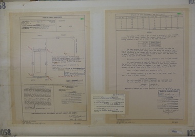
Planning Document, Subdivision Plan #1058. Wattle Drive Watsonia, 14/07/1983
... An example of hard copy subdivision plans from the Greensborough area. Mainly from the Shire of Diamond Valley era (1964-1994). subdivision plans wattle drive watsonia Stamped and handwritten Council permissions, dates and other details. ...Plan of Strata Subdivision at 6 Wattle Drive Watsonia for 6 units.An example of hard copy subdivision plans from the Greensborough area. Mainly from the Shire of Diamond Valley era (1964-1994).Plan (3 sheets) mounted on heavy card.Stamped and handwritten Council permissions, dates and other details.subdivision plans, wattle drive watsonia -
 Greensborough Historical Society
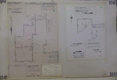
Planning Document, Subdivision Plan #1041. Elder Street Greensborough, 20/04/1983
... Subdivision Plan #1041. Elder Street Greensborough . ...Subdivision Plan #1041. Elder Street Greensborough . Planning Document O'Connor and Beveridge ...Plan of Consolidation of Allotments 3 and 4 Brixton Avenue and Plan of Subdivision for Elder Street. An example of hard copy subdivision plans from the Greensborough area. Mainly from the Shire of Diamond Valley era (1964-1994).Plan (2 sheets) mounted on heavy card.Stamped and handwritten Council permissions, dates and other details.subdivision plans, elder street, brixton avenue -
 Greensborough Historical Society
Planning Document, Subdivision Plan # 1060, 8 Ulmara Place Greensborough, 20/04/1983
... Subdivision Plan # 1060, 8 Ulmara Place Greensborough. ...Plan of Strata Subdivision at 8 Ulmara Place Greensborough for 2 houses....An example of hard copy subdivision plans from the Greensborough area. Mainly from the Shire of Diamond Valley era (1964-1994). subdivision plans ulmara place Stamped and handwritten Council permissions, dates and other details. ...Plan of Strata Subdivision at 8 Ulmara Place Greensborough for 2 houses.An example of hard copy subdivision plans from the Greensborough area. Mainly from the Shire of Diamond Valley era (1964-1994).Plan (3 sheets) mounted on heavy card.Stamped and handwritten Council permissions, dates and other details.subdivision plans, ulmara place -
 Greensborough Historical Society
Folder of documents, Black Family in Greensborough and Watsonia, 1924o
... Collection of copies of documents and plans relating to land owned by the Black Family in Greensborough and Watsonia, and its sale by auction and subdivision to form the suburb of Watsonia following the building of Watsonia Railway Station in 1924...Greensborough Historical Society 34A Glenauburn Road Lower Plenty Lower Plenty melbourne Collection of copies of documents and plans relating to land owned by the Black Family in Greensborough and Watsonia, and its sale by auction and subdivision to form the suburb of Watsonia following the building of Watsonia Railway Station in 1924 History of the development of the suburb of Watsonia black family watsonia Loose-leaf folder, pages in file protectors Black Family in Greensborough and Watsonia Folder of documents Greensborough Historical Society ...Collection of copies of documents and plans relating to land owned by the Black Family in Greensborough and Watsonia, and its sale by auction and subdivision to form the suburb of Watsonia following the building of Watsonia Railway Station in 1924History of the development of the suburb of WatsoniaLoose-leaf folder, pages in file protectorsblack family, watsonia -
 Greensborough Historical Society
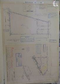
Planning document, Subdivision Plan #1128. St Helena Road Greensborough, 1985_
... Subdivision Plan #1128. St Helena Road Greensborough....(superseded plan) An example of hard copy subdivision plans from the Greensborough area. Mainly from the Shire of Diamond Valley era (1964-1994). subdivision plans st helena road Stamped and handwritten Council permissions, dates and other details. ...Plan of Subdivision for property at St Helena Road. (superseded plan)An example of hard copy subdivision plans from the Greensborough area. Mainly from the Shire of Diamond Valley era (1964-1994).Plan (2 sheets) mounted on heavy card.Stamped and handwritten Council permissions, dates and other details. Notation: 'Superseded plan see G1190'subdivision plans, st helena road -
 Greensborough Historical Society
Planning Document, Subdivision Plan # 1016. Corner Weidlich and St Clems Roads Greensborough, 05/10/1981
... Subdivision Plan # 1016. Corner Weidlich and St Clems Roads Greensborough....Plan of Subdivision of land at corner of Weidlich Road and St Clems Road Greensborough....Greensborough Historical Society 34A Glenauburn Road Lower Plenty Lower Plenty melbourne Plan of Subdivision of land at corner of Weidlich Road and St Clems Road Greensborough. subdivision plans weidlich road Stamped and handwritten Council permissions, dates and other details. ...Plan of Subdivision of land at corner of Weidlich Road and St Clems Road Greensborough.Plan (2 sheets) mounted on heavy card.Stamped and handwritten Council permissions, dates and other details.subdivision plans, weidlich road -
 Greensborough Historical Society
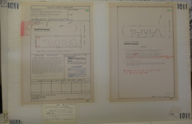
Planning document, Subdivision Plan #1011. Corner Mountainview Road and Hume Streets, 1981_
... An example of hard copy subdivision plans from the Greensborough area. Mainly from the Shire of Diamond Valley era (1964-1994). subdivision plans mountainview road hume street Stamped and handwritten Council permissions, dates and other details. ...Plan of Strata Subdivision for units at corner of Mountainview Road and Hume Street Briar Hill.An example of hard copy subdivision plans from the Greensborough area. Mainly from the Shire of Diamond Valley era (1964-1994).Plan (2 sheets) mounted on heavy card.Stamped and handwritten Council permissions, dates and other details.subdivision plans, mountainview road, hume street -
 Greensborough Historical Society
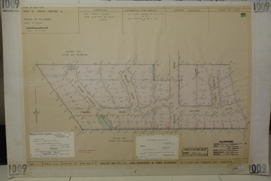
Planning document, Subdivision Plan #1009. Corner Allumba Drive and Beales Road Greensborough, 1981_
... Subdivision Plan #1009. Corner Allumba Drive and Beales Road Greensborough....Plan of Subdivision of land at corner of Allumba Drive and Beales Road Greensborough....An example of hard copy subdivision plans from the Greensborough area. Mainly from the Shire of Diamond Valley era (1964-1994). subdivision plans allumba drive beales road Stamped and handwritten Council permissions, dates and other details. ...Plan of Subdivision of land at corner of Allumba Drive and Beales Road Greensborough.An example of hard copy subdivision plans from the Greensborough area. Mainly from the Shire of Diamond Valley era (1964-1994).Plan (2 sheets) mounted on heavy card.Stamped and handwritten Council permissions, dates and other details.subdivision plans, allumba drive, beales road -
 Greensborough Historical Society
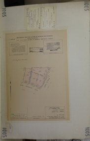
Planning document, Subdivision Plan #1005. Corner Douglas Court and Glen Katherine Drive Greensborough, 1981_
... Subdivision Plan #1005. Corner Douglas Court and Glen Katherine Drive Greensborough....Plan of Subdivision. Corner Douglas Court and Glen Katherine Drive Greensborough....Corner Douglas Court and Glen Katherine Drive Greensborough. An example of hard copy subdivision plans from the Greensborough area. ...Plan of Subdivision. Corner Douglas Court and Glen Katherine Drive Greensborough.An example of hard copy subdivision plans from the Greensborough area. Mainly from the Shire of Diamond Valley era (1964-1994).Plan (2 sheets) mounted on heavy card.Stamped and handwritten Council permissions, dates and other details.subdivision plans, douglas court, glen katherine drive -
 Greensborough Historical Society
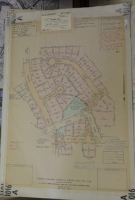
Planning document, City of Heidelberg, Subdivision Plan # G26. Grace Park Estate Greensborough, 1950c
... Subdivision Plan # G26. Grace Park Estate Greensborough....An example of hard copy subdivision plans from the Greensborough area. From Shire of Heidelberg. subdivision plans grace park Stamped and handwritten Council permissions, dates and other details. ...Plan of Subdivision (G26). Grace Park Estate. An example of hard copy subdivision plans from the Greensborough area. From Shire of Heidelberg.Plan mounted on heavy card.Stamped and handwritten Council permissions, dates and other details.subdivision plans, grace park -
 Greensborough Historical Society
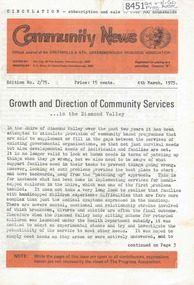
Newsletter, Greenhills and North Greensborough Progress Association, Community News: official journal of the Greenhills and Nth. Greensborough Progress Association. 4th March, 1975. Edition No. 2/75, 04/03/1975
... This edition includes a report on the Progress Association's February 1975 meeting, Councillor's report, Growth and direction of community services... in the Diamond Valley, This and that, Public display... outline development plan and subdivision, Diamond Valley Repertory, Kinder news, Re-union... with the Morton family, Scout and Guide news (Scout hall to open), Supplement to "Community News". No. 2/75. Meet the natives. A digital copy of this Newsletter is available from Greensborough...Greensborough Historical Society 34A Glenauburn Road Lower Plenty Lower Plenty melbourne This edition includes a report on the Progress Association's February 1975 meeting, Councillor's report, Growth and direction of community services... in the Diamond Valley, This and that, Public display... outline development plan and subdivision, Diamond Valley Repertory, Kinder news, Re-union... with the Morton family, Scout and Guide news (Scout hall to open), Supplement to "Community News". ...This edition includes a report on the Progress Association's February 1975 meeting, Councillor's report, Growth and direction of community services... in the Diamond Valley, This and that, Public display... outline development plan and subdivision, Diamond Valley Repertory, Kinder news, Re-union... with the Morton family, Scout and Guide news (Scout hall to open), Supplement to "Community News". No. 2/75. Meet the natives. A digital copy of this Newsletter is available from Greensborough Historical Society.Newsletter, 20 p., illus.greenhills and north greensborough progress association, greenhills -
 Greensborough Historical Society
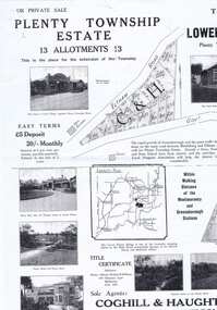
Plan - Advertising Leaflet, Coghill & Haughton, Plenty Township Estate and Bryn Teg Hill's Estate, 1925c
... Greensborough Historical Society 34A Glenauburn Road Lower Plenty Lower Plenty melbourne Copy of Real Estate Agent's advertising leaflet for two subdivisions, the Plenty Township Estate and Bryn Teg Hill's Estate in Lower Plenty, by order of Mrs M Thomas (d. 1925) lower plenty bryn teg plenty river Black and white photocopy of advertising leaflet Plenty Township Estate and Bryn Teg Hill's Estate Plan Advertising Leaflet Coghill & Haughton ...Copy of Real Estate Agent's advertising leaflet for two subdivisions, the Plenty Township Estate and Bryn Teg Hill's Estate in Lower Plenty, by order of Mrs M Thomas (d. 1925)Black and white photocopy of advertising leafletlower plenty, bryn teg, plenty river -
 Greensborough Historical Society
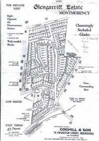
Plan, Coghill and Son, Glengarriff Estate Montmorency, 1938c
... Greensborough Historical Society 34A Glenauburn Road Lower Plenty Lower Plenty melbourne Plan for the Glengarriff Estate covers 171 lots in vicinity of Montmorency Railway Station, for private sale, controlling agents Coghill & Son, Local Agents Shallard Bros, Main Road Eltham. C/T 6068/1213512 formerly owned by George Nicholson, dentist. montmorency glengarriff estate montmorency calrossie street montmorency Black and white photocopy of a real estate agent's plan of subdivision Glengarriff Estate Montmorency Plan Coghill and Son ...Plan for the Glengarriff Estate covers 171 lots in vicinity of Montmorency Railway Station, for private sale, controlling agents Coghill & Son, Local Agents Shallard Bros, Main Road Eltham. C/T 6068/1213512 formerly owned by George Nicholson, dentist.Black and white photocopy of a real estate agent's plan of subdivision montmorency, glengarriff estate montmorency, calrossie street montmorency -
 Greensborough Historical Society
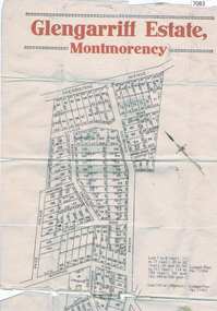
Map, Glengarriff Estate Montmorency, 1938c
... Greensborough Historical Society 34A Glenauburn Road Lower Plenty Lower Plenty melbourne Estate Agent's plan of Glengarriff Estate, Montmorency, covering LPs 11334 and 11451. Bordered by Sherbourne Avenue, Calrossie Avenue, Montmorency Station and Price Avenue glengarriff estate montmorency sherbourne avenue montmorency calrossie avenue montmorency price avenue montmorency montmorency station Colour photocopy of subdivision map, on two A3 sheets Glengarriff Estate Montmorency Map T. ...Estate Agent's plan of Glengarriff Estate, Montmorency, covering LPs 11334 and 11451. Bordered by Sherbourne Avenue, Calrossie Avenue, Montmorency Station and Price AvenueColour photocopy of subdivision map, on two A3 sheets glengarriff estate montmorency, sherbourne avenue montmorency, calrossie avenue montmorency, price avenue montmorency, montmorency station -
 Greensborough Historical Society
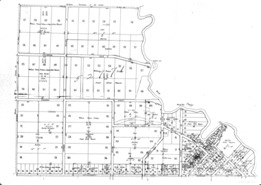
Maps, Greensborough. Parish Plan 1860, 1860c
... This plan show Green's subdivision of Greensborough, north of Grimshaw Street....Greensborough Historical Society 34A Glenauburn Road Lower Plenty Lower Plenty melbourne This plan show Green's subdivision of Greensborough, north of Grimshaw Street. greensborough grimshaw street greensborough edward bernard green One copy possibly from 1860, containing lot numbers for a government road, now Main Street, and surrounding streets. ...This plan show Green's subdivision of Greensborough, north of Grimshaw Street.Enlargements of Parish plan circa 1860?One copy possibly from 1860, containing lot numbers for a government road, now Main Street, and surrounding streets.greensborough, grimshaw street greensborough, edward bernard green -
 Greensborough Historical Society
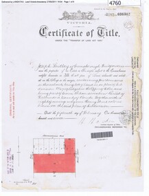
Certificate of Title, Certificate of Title Vol. 3182 Fol. 302, 15/02/1907
... Title in the name of Joseph Laidlay of Greensborough, fruitgrower, 14 acres being Lots 7, 8 and 22 on Plan of subdivision 4759, part of Crown portion 17, Parish of Keelbundora County of Bourke, dated 15th February 1907. ...Greensborough Historical Society 34A Glenauburn Road Lower Plenty Lower Plenty melbourne Title in the name of Joseph Laidlay of Greensborough, fruitgrower, 14 acres being Lots 7, 8 and 22 on Plan of subdivision 4759, part of Crown portion 17, Parish of Keelbundora County of Bourke, dated 15th February 1907. ...Title in the name of Joseph Laidlay of Greensborough, fruitgrower, 14 acres being Lots 7, 8 and 22 on Plan of subdivision 4759, part of Crown portion 17, Parish of Keelbundora County of Bourke, dated 15th February 1907. Northern boundary Greensborough (now Grimshaw) Road, Eastern boundary Henry Street.1 p. colour copy of Titlegreensborough, grimshaw street greensborough, henry street greensborough, joseph laidlay -
 Greensborough Historical Society
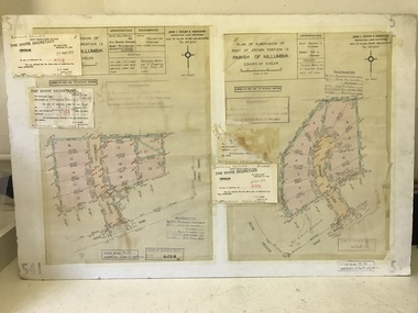
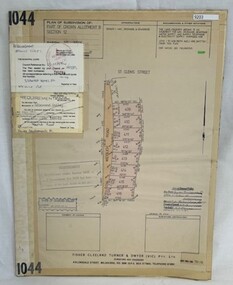
Poster - Planning Document, Shire of Diamond Valley et al, Subdivision Plan # 1044 - Parish of Nillumbik, County Bourke, Crown Allotment B Section 12, Eltham North, 1981-1987
... subdivision plan includes Weidlich Road and St Clems Street. The developer for this subdivision is Taunton Developments and the Surveyors are Fisher Cleeland Turner & Dwyer Vic, Surveyors and Engineers. An example of hard copy subdivision plans from the Greensborough ...Subdivision Plan # 1044 - Parish of Nillumbik, County Bourke, Crown Allotment B Section 12, Eltham North. This subdivision plan includes Weidlich Road and St Clems Street. The developer for this subdivision is Taunton Developments and the Surveyors are Fisher Cleeland Turner & Dwyer Vic, Surveyors and Engineers.An example of hard copy subdivision plans from the Greensborough area. Mainly from the Shire of Diamond Valley era (1964-1994).Plan (single sided) mounted on heavy card. Stamped and handwritten Council permissions, dates and other details. subdivision plans, shire of diamond valley, taunton developments -
 Greensborough Historical Society
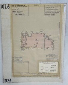
Poster - Planning Document, Shire of Diamond Valley et al, Subdivision Plan # 1026 - Parish of Nillumbik, County Bourke, Crown Allotment B Section 12, Eltham North, 1981-1984
... subdivision plan includes Ryans Road (also known as Government Road) and St Clems Street. The developer for this subdivision is Taunton Developments and the Surveyors are Fisher Cleeland Turner & Dwyer Vic, Surveyors and Engineers. An example of hard copy subdivision plans from the Greensborough ...Subdivision Plan # 1026 - Parish of Nillumbik, County Bourke, Crown Allotment B Section 12, Eltham North. This subdivision plan includes Ryans Road (also known as Government Road) and St Clems Street. The developer for this subdivision is Taunton Developments and the Surveyors are Fisher Cleeland Turner & Dwyer Vic, Surveyors and Engineers.An example of hard copy subdivision plans from the Greensborough area. Mainly from the Shire of Diamond Valley era (1964-1994).Plan (single sided) mounted on heavy card. Stamped and handwritten Council permissions, dates and other details. subdivision plans, shire of diamond valley, taunton developments