Showing 151 items matching "submerged"
-
 Eltham District Historical Society Inc
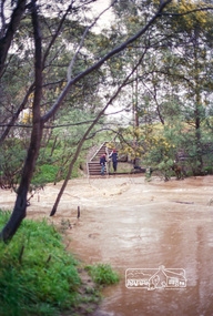
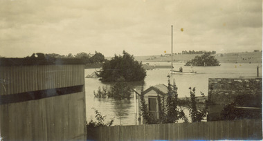
Negative - Photograph, Harry Gilham, Diamond Creek in flood, looking west towards Eltham High School (across submerged footbridge), c.Aug. 1996
... Diamond Creek in flood, looking west towards Eltham High School (across submerged footbridge)...This (submerged) footbridge has since been replaced by a higher-level bridge and the steps have been abolished....Eltham District Historical Society Inc 728 Main Rd Eltham melbourne This (submerged) footbridge has since been replaced by a higher-level bridge and the steps have been abolished. diamond creek floods dalton street wingrove park trail eltham high school Kodak Gold 100-5 Roll of 35mm colour negative film, 5 of 6 strips Diamond Creek in flood, looking west towards Eltham High School (across submerged footbridge) Negative Photograph Harry Gilham ...This (submerged) footbridge has since been replaced by a higher-level bridge and the steps have been abolished.Roll of 35mm colour negative film, 5 of 6 stripsKodak Gold 100-5diamond creek, floods, dalton street, wingrove park trail, eltham high school -
 Eltham District Historical Society Inc
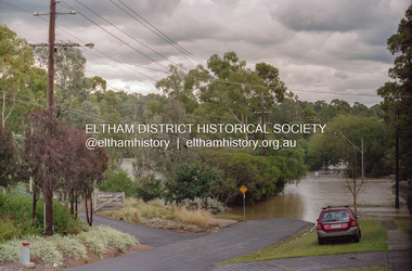
Photograph, Diamond Creek floodwaters, Brougham St Bridge submerged, Eltham, February 2005
... Diamond Creek floodwaters, Brougham St Bridge submerged, Eltham...Eltham District Historical Society Inc 728 Main Rd Eltham melbourne diamond creek eltham floods Kodak GC400-8 Roll of 35mm colour negative film, 7 strips Diamond Creek floodwaters, Brougham St Bridge submerged, Eltham Photograph Photograph ...Roll of 35mm colour negative film, 7 stripsKodak GC400-8diamond creek, eltham, floods -
 Eltham District Historical Society Inc
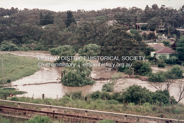
Slide, Footbridge at Greensborough submerged under floodwater, November 1971, 1971
... Footbridge at Greensborough submerged under floodwater, November 1971...Eltham District Historical Society Inc 728 Main Rd Eltham melbourne floods, Foot bridge, Greensborough 35 mm colour positive transparency Mount - Agfacolor Service (Blue) Footbridge at Greensborough submerged under floodwater, November 1971 Slide Slide ...35 mm colour positive transparency Mount - Agfacolor Service (Blue)floods, foot bridge, greensborough -
 Darebin Art Collection
Painting, David McLeod, 'Submerged', 2012
... 'Submerged'...Streets 'Submerged' Painting David McLeod ..."I live in an area of Darebin where creeks and lagoons are surrounded by sprawling brick houses and light industry perches on the tops of bluffs. It's where suburbia encroaches uneasily on the natural environment. I comment on this situation but also try to create a poignant narrative from it." - David McLeodstreets -
 National Vietnam Veterans Museum (NVVM)
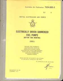
Manual, Royal Australian Air Force, Electrically Driven Submerged Fuel Pumps (Bottom Tank Mounting) (S.P.E.)
... Electrically Driven Submerged Fuel Pumps (Bottom Tank Mounting) (S.P.E.)...Electrically Driven Submerged Fuel Pumps (Bottom Tank Mounting) (S.P.E.) ...A gray plastic folder with a plastic insert at the front. In this insert there is a yellow paper with Australian Air Publication 7434.005-3 No. 8 top right hand corner. Above the Royal Australian Air Force Insignia reads Royal Australian Air Force. the rest of the information is under the insignia in black ink. Down the spine of the manual there is also a plastic insert with yellow paper that has the information in black ink. the manual is held together with metal supports.royal australian airforce - manuals, fuel pumps, bottom tank mounting -
 Moorabbin Air Museum
Manual (Item) - Thompson Aircraft Submerged Fuel Booster Pump - 2 copies
... Thompson Aircraft Submerged Fuel Booster Pump - 2 copies...Moorabbin Air Museum Moorabbin Airport 12 First Street Moorabbin melbourne Thompson Aircraft Submerged Fuel Booster Pump - 2 copies Manual Thompson Aircraft Submerged Fuel Booster Pump - 2 copies ... -
Moorabbin Air Museum
Manual (Item) - Thompson Aircraft Submerged Fuel Booster Pumps Handbook
... Thompson Aircraft Submerged Fuel Booster Pumps Handbook...Moorabbin Air Museum Moorabbin Airport 12 First Street Moorabbin melbourne Thompson Aircraft Submerged Fuel Booster Pumps Handbook Manual Thompson Aircraft Submerged Fuel Booster Pumps Handbook ... -
Federation University Art Collection
Bookplate, ‘Ex Libris Edwin Jewell’
... A swimmer in colourful costume is depicted swimming under water amongst submerged columns...The society was instrumental in promoting the art of the bookplate through establishment of the Australian Bookplate Design competition. bookplate printmaking australian bookplate design award keith wingrove memorial trust A swimmer in colourful costume is depicted swimming under water amongst submerged columns ‘Ex Libris Edwin Jewell’ Bookplate ...After a quiet period, interest in bookplates in Australia began to increase in the early 1970s, Entrepreneurial art and book collectors such as Edwin Jewell and others commissioned multiple Bookplate designs from a range of well known fine artists. At a 1997 meeting in Melbourne of the Ephemera Society of Australia Edwin Jewell and others announced the formation of the Australian Bookplate Society. The society was instrumental in promoting the art of the bookplate through establishment of the Australian Bookplate Design competition.A swimmer in colourful costume is depicted swimming under water amongst submerged columnsbookplate, printmaking, australian bookplate design award, keith wingrove memorial trust -
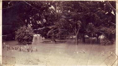
 Kew Historical Society Inc
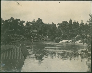
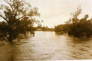
Photograph - Flood at Fairfield Park, 1934
... Major flood resulting in submerged buildings in middle ground and onlookers on far bank...Major flood resulting in submerged buildings in middle ground and onlookers on far bank Photograph Flood at Fairfield Park ...Flooding of the Yarra Valley, including that section of the Yarra bordering Kew and Kew East in the north and west of the municipality, was a regular occurrence. Extreme flood events of the Yarra River are recorded to have occurred in 1891, 1901, 1916, 1923 and 1934. The Municipality of Kew's response to these floods was to enact planning decisions restricting residential development in flood prone areas following the floods of 1916, 1921 and 1934. While floods continued after the development of the Upper Yarra Reservoir (construction 1948-57), the regularity and extent of these inundations diminished.Black and white print positive. Yarra River at Fairfield in 1934. Major flood resulting in submerged buildings in middle ground and onlookers on far bankReverse: "Flood of Yarra at Fairfield Park 1934"fairfield park, yarra valley, river yarra, floods -- 1934 -
 Kew Historical Society Inc
Photograph - Flooding of the Yarra River in North Kew, 1934
... Small sepia snapshot of what was then River Avenue, North Kew submerged by floodwaters.The photo was taken in the vicinity of 8 Kellett Grove, North Kew. ...Prior to urban development, the area since European settlement and the first land sales in the district in the 1840s, had been used for dairy farming. . yarra river -- north kew floods -- yarra valley floods -- north kew floods -- 1934 natural disasters -- kew Verso: TAKEN FROM OUR STREET JUST SEE A BIT OF RYAN'S FENCE / 1934 Small sepia snapshot of what was then River Avenue, North Kew submerged by floodwaters.The photo was taken in the vicinity of 8 Kellett Grove, North Kew. ...North Kew, now divided between Kew and Kew East, bordered the Yarra River. As such, it was a region subject to flooding in the Yarra Valley. Development beyond this point (ie Kellett Grove) was limited by the City of Kew's planning regulations. Prior to urban development, the area since European settlement and the first land sales in the district in the 1840s, had been used for dairy farming. .Small sepia snapshot of what was then River Avenue, North Kew submerged by floodwaters.The photo was taken in the vicinity of 8 Kellett Grove, North Kew. Verso: TAKEN FROM OUR STREET JUST SEE A BIT OF RYAN'S FENCE / 1934yarra river -- north kew, floods -- yarra valley, floods -- north kew, floods -- 1934, natural disasters -- kew -
Glenelg Shire Council Cultural Collection
Photograph - Photograph - Main Breakwater construction, Portland, n.d
... Rows of concrete piles partly submerged in the sea, plus several workmen, on left. ...Rows of concrete piles partly submerged in the sea, plus several workmen, on left. ...Port of Portland Authority Archivesport of portland archives, main breakwater, construction, harbour development -
 Kew Historical Society Inc
Photograph, Burke Road Bridge, 1930s
... The previous bridge, constructed in 1926 was submerged beneath the flood waters in the 1934 mega-flood of the Yarra....The previous bridge, constructed in 1926 was submerged beneath the flood waters in the 1934 mega-flood of the Yarra. ...Without bridges, Kew remained cut off from the City of Melbourne, only being accessible by Punt. Private and public bridges were constructed from the 1850s, beginning with the Hawthorn Bridge linking Bridge and Burwood Roads. A bridge across the Yarra at Burke Road was created as early as 1873. Since that first wooden bridge, a number of later bridges, typically on concrete pylons have been built, in 1926 and again during the 1970s.Sepia, faded photograph of the Burke Road Bridge linking East Kew and Ivanhoe. The previous bridge, constructed in 1926 was submerged beneath the flood waters in the 1934 mega-flood of the Yarra.burke road bridge (kew), bridges -- river yarra -
 Ballaarat Mechanics' Institute (BMI Ballarat)
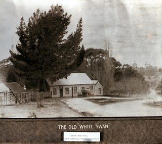
White Swan Hotel now submerged
... ...submerged...Ballarat hotel White Swan submerged White Swan Hotel now submerged ...This photograph is from the Max Harris Collection held by the Ballaraat Mechanics' Institute. Please contact BMI for all print and usage inquiries.ballarat, hotel, white swan, submerged -
 Charlton Golden Grains Museum Inc
Photograph, 1923 Floods, 01/05/2008
... The water tower in the middle of picture. Submerged backyards are visible only....The water tower in the middle of picture. Submerged backyards are visible only. Unframed landscape Sepia 1923 Floods Photograph ...Unframed landscape Sepia(Looking accross river towards Tower on Clifton Hill) - The Tower is arrowed - 1st August 1923, Charlton Floods. The arrow indicates highest point in Charlton. The water tower in the middle of picture. Submerged backyards are visible only.floods 1923 -
Glenelg Shire Council Cultural Collection
Postcard - Postcard - Flooding in Casterton, n.d
... Water halfway up tin fence, man standing on railing, tractor towing horse float, flooded shed, trees part submerged, no dry land visible...Water halfway up tin fence, man standing on railing, tractor towing horse float, flooded shed, trees part submerged, no dry land visible Postcard Postcard - Flooding in Casterton J.T. ...SOURCED FROM CASTERTON TOWN HALL (FORMER SHIRE OF GLENELG) Sourced From Casterton Town Hall (Former Shire of Glenelg)Black and white photo postcard. 1946 flood. Water halfway up tin fence, man standing on railing, tractor towing horse float, flooded shed, trees part submerged, no dry land visibleBack: Purple stamp - 'POSTCARD' Purple photographer's stamp -
 Kew Historical Society Inc
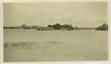
Photograph - Submerged houses in River Avenue, North Kew, 1934
... Small sepia snapshot of two submerged houses belonging to local families in River Avenue, North Kew, during the 1934 floods. ...The view is presumably from near Kellett Grove looking north towards Fairfield. Photograph Submerged houses in River Avenue, North Kew ...North Kew, now divided between Kew and Kew East, bordered the Yarra River. As such, it was a region subject to flooding in the Yarra Valley. Development beyond this point (ie Kellett Grove) was limited by the City of Kew's planning regulations. Prior to urban development, the area since European settlement and the first land sales in the district in the 1840s, had been used for dairy farming. Vivid photograph contrasting domestic life and relationships with natural disasters such as the flood of 1934.Small sepia snapshot of two submerged houses belonging to local families in River Avenue, North Kew, during the 1934 floods. The view is presumably from near Kellett Grove looking north towards Fairfield.Verso: COES & HYATTS ROOF / RIVER AVENUE / Stamped: 6414yarra river -- north kew, floods -- yarra valley, floods -- north kew, floods -- 1934, natural disasters -- kew -
 Kew Historical Society Inc
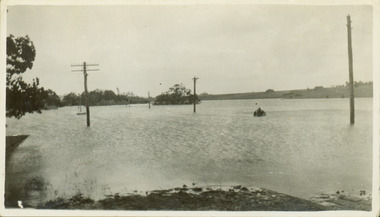
Photograph - Flooding of the Yarra River in North Kew, 1934
... Floodwaters have submerged the fence and a clothes line. ...Floodwaters have submerged the fence and a clothes line. Photograph Flooding of the Yarra River in North Kew ...North Kew, now divided between Kew and Kew East, bordered the Yarra River. As such, it was a region subject to flooding in the Yarra Valley. Development beyond this point (ie Kellett Grove) was limited by the City of Kew's planning regulations. Prior to urban development, the area since European settlement and the first land sales in the district in the 1840s, had been used for dairy farming. Small sepia snapshot taken from the back yard of a house at 8 Kellett Grove, in what was then known as North Kew. The point of view is from a backyard looking towards Fairfield. Floodwaters have submerged the fence and a clothes line. Verso: BACKYARD NTH. KEWyarra river -- north kew, floods -- yarra valley, floods -- north kew, floods -- 1934, natural disasters -- kew -
 Kew Historical Society Inc
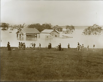
Photograph - Yarra in Flood from Willsmere, North Kew, 1923
... In the medium distance are three houses that are largely submerged by the flood waters as well as a number of Eucalypts. ...In the medium distance are three houses that are largely submerged by the flood waters as well as a number of Eucalypts. ...Flooding of the Yarra Valley, including that section of the Yarra bordering Kew and Kew East in the north and west of the municipality, was a regular occurrence. Extreme flood events of the Yarra River are recorded to have occurred in 1891, 1901, 1916, 1923 and 1934. The Municipality of Kew's response to these floods was to enact planning decisions restricting residential development in flood prone areas following the floods of 1916, 1921, and 1934. While floods continued after the development of the Upper Yarra Reservoir (construction 1948-57), the regularity and extent of these inundations diminished. Original, large sepia photograph showing men, women and children who have gathered on a grassy verge, probably farm land, to look out across the flooded Yarra Valley at Willsmere, North Kew. In the medium distance are three houses that are largely submerged by the flood waters as well as a number of Eucalypts. Inscribed reverse: "Gift of Kerrie Woollard (KCC) (P)C.1923yarra river valley, kew east (vic.), floods, willsmere -
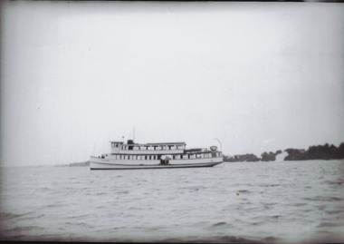 Lakes Entrance Historical Society
Photograph - Estelle Star Pre 1955, Bulmer, Pre 1955
... Further information on Estelle Star modified at Cowes, posted by Submerged on Aug 9 2017 is with paper catalogue sheet...Further information on Estelle Star modified at Cowes, posted by Submerged on Aug 9 2017 is with paper catalogue sheet Boats and Boating ferries Fishing Boats Black and white photograph of ferry Estelle Star before she was converted to a fishing vessel in 1955 Lakes Entrance Victoria Photograph Estelle Star Pre 1955 Bulmer ...Further information on Estelle Star modified at Cowes, posted by Submerged on Aug 9 2017 is with paper catalogue sheetBlack and white photograph of ferry Estelle Star before she was converted to a fishing vessel in 1955 Lakes Entrance Victoriaboats and boating, ferries, fishing boats -
 Phillip Island and District Historical Society Inc.
Newspaper, Eagle star ferry sinks, 30 December 1978
... Fleet" plucks 160 from bay" Large black and white photo showing half submerged ferry and three smaller motor boats pulling people from the water. other people are standing on the front of the ferry....Fleet" plucks 160 from bay" Large black and white photo showing half submerged ferry and three smaller motor boats pulling people from the water. other people are standing on the front of the ferry. ...The Eagle Star left from Stony Point to take in Tankerton on the way to Cowes. It carried about 160 passengers of all ages, many of whom were probably planning to celebrate New Year’s Eve or start their holidays on the Island. The 48-year-old ferry had only recently been bought by a co-operative of French Island residents. Fortunately no one was drowned, and only two people were hurt.HistoricalBroadsheet front page from The Herald Saturday, December 30 1978.Headline is "Ferry sinks."Fleet" plucks 160 from bay" Large black and white photo showing half submerged ferry and three smaller motor boats pulling people from the water. other people are standing on the front of the ferry.Headline is "Ferry sinks."Fleet" plucks 160 from bay" ferries, eagle star, transport, cowes yacht club -
 Clunes Museum
Photograph, FLOODS 1934
... AFTER HEAVY RAINS - CRESWICK CREEK IN CLUNES TOWNSHIP FLOODED, OVER FLOWING ITS BANKS, NEAR BY AREAS WERE SUBMERGED....Clunes Museum 36 Fraser Street enter building through Collins Place Clunes goldfields AFTER HEAVY RAINS - CRESWICK CREEK IN CLUNES TOWNSHIP FLOODED, OVER FLOWING ITS BANKS, NEAR BY AREAS WERE SUBMERGED. local history queen's park garden. ...AFTER HEAVY RAINS - CRESWICK CREEK IN CLUNES TOWNSHIP FLOODED, OVER FLOWING ITS BANKS, NEAR BY AREAS WERE SUBMERGED.BLACK AND WHITE SMALL PHOTOGRAPH OF CLUNES FLOODS IN 1934. CLUNES QUEEN'S PARK WITH FOUNTAIN UNDER WATER - TREES IN THE BACKGROUND AND A FEW FLOWERS IN THE FOREGROUND.local history, queen's park garden., floods 1934 -
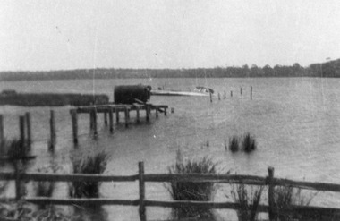 Lakes Entrance Historical Society
Photograph - abandoned jetty at Lake Tyers c1930
... showing submerged boat at end of jetty, boiler from steamer Firefly supported in shallow water, post and rail fence in foreground...showing submerged boat at end of jetty, boiler from steamer Firefly supported in shallow water, post and rail fence in foreground Waterways Boats and Boating Ships and Shipping Black and white photograph of an abandoned jetty at Lake Tyers, . ...showing submerged boat at end of jetty, boiler from steamer Firefly supported in shallow water, post and rail fence in foregroundBlack and white photograph of an abandoned jetty at Lake Tyers, . Lake Tyers Victoriawaterways, boats and boating, ships and shipping -
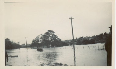 Kew Historical Society Inc
Photograph - Flooding of the Yarra River in North Kew, 1934
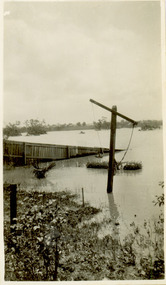
... In the foreground are two figures viewing a group in a rowboat in the middle of the flooded river. Semi-submerged street lighting indicates that entire streets had been. overwhelmed by the flood waters. ...In the foreground are two figures viewing a group in a rowboat in the middle of the flooded river. Semi-submerged street lighting indicates that entire streets had been. overwhelmed by the flood waters. ...North Kew, now divided between Kew and Kew East, bordered the Yarra River. As such, it was a region subject to flooding in the Yarra Valley. Development beyond this point (ie Kellett Grove) was limited by the City of Kew's planning regulations. Prior to urban development, the area since European settlement and the first land sales in the district in the 1840s, had been used for dairy farming. Small sepia snapshot of floodwaters taken from near Willsmere Road, in what was then known as North Kew. The point of view is looking towards Fairfield. In the foreground are two figures viewing a group in a rowboat in the middle of the flooded river. Semi-submerged street lighting indicates that entire streets had been. overwhelmed by the flood waters. Verso: WILLSMERE ROAD NORTH KEW / Stamped 3 163yarra river -- north kew, floods -- yarra valley, floods -- north kew, floods -- 1934, natural disasters -- kew, willsmere road -
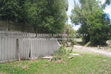 Eltham District Historical Society Inc
Photograph, Fay Bridge, Flood damage at Nillumbik Medical Centre, 1078 Main Road, Eltham, 26 December 2011
... A flash flood occurred from significant rain fall and hail, which accumulated along an old waterway with floodwater submerging cars along Valonia Drive then down Grove Street flooding houses, through the Bible Street Reserve where it then submerged Main Road washing away the small railway trestle bridge opposite the reserve then flooding the Judge Book Village before finally entering the Diamond Creek.....A flash flood occurred from significant rain fall and hail, which accumulated along an old waterway with floodwater submerging cars along Valonia Drive then down Grove Street flooding houses, through the Bible Street Reserve where it then submerged Main Road washing away the small railway trestle bridge opposite the reserve then flooding the Judge Book Village before finally entering the Diamond Creek.. ...Flood damage resulting from a late afternoon storm on Christmas Day 2011. A flash flood occurred from significant rain fall and hail, which accumulated along an old waterway with floodwater submerging cars along Valonia Drive then down Grove Street flooding houses, through the Bible Street Reserve where it then submerged Main Road washing away the small railway trestle bridge opposite the reserve then flooding the Judge Book Village before finally entering the Diamond Creek..fay bridge collection, 2011-12-26, bible street reserve, flood damage, floods, floodwater, main road, nillumbik medical centre -
 Kew Historical Society Inc
Photograph - Flooding of the Yarra River in North Kew, 1934
... Beyond the fence line are two almost submerged houses. A number of people are in a motor driven boat midstream. ...Beyond the fence line are two almost submerged houses. A number of people are in a motor driven boat midstream. ...North Kew, now divided between Kew and Kew East, bordered the Yarra River. As such, it was a region subject to flooding in the Yarra Valley. Development beyond this point (ie Kellett Grove) was limited by the City of Kew's planning regulations. Prior to urban development, the area since European settlement and the first land sales in the district in the 1840s, had been used for dairy farming. Small sepia snapshot taken from the river ramp of a house at 8 Kellett Grove, in what was then known as North Kew. The point of view is from a backyard looking towards Fairfield. Beyond the fence line are two almost submerged houses. A number of people are in a motor driven boat midstream. Fairfield at this period, (ie 1934) was noted for its limited river side development. Verso: 2/12/34 / TAKEN FROM OUR RAMPyarra river -- north kew, floods -- yarra valley, floods -- north kew, floods -- 1929, floods -- 1934, natural disasters -- kew -
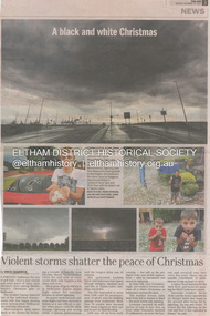 Eltham District Historical Society Inc
Newsclipping, Vince Chadwick, Violent storms shatter the peace of Christmas, The Age, Monday, December 26, p3, 2011
... A flash flood occurred from significant rain fall and hail, which accumulated along an old waterway with floodwater submerging cars along Valonia Drive then down Grove Street flooding houses, through the Bible Street Reserve where it then submerged Main Road washing away the small railway trestle bridge opposite the reserve then flooding the Judge Book Village before finally entering the Diamond Creek. ...A flash flood occurred from significant rain fall and hail, which accumulated along an old waterway with floodwater submerging cars along Valonia Drive then down Grove Street flooding houses, through the Bible Street Reserve where it then submerged Main Road washing away the small railway trestle bridge opposite the reserve then flooding the Judge Book Village before finally entering the Diamond Creek. ...A late afternoon storm on Christmas Day 2011. A flash flood occurred from significant rain fall and hail, which accumulated along an old waterway with floodwater submerging cars along Valonia Drive then down Grove Street flooding houses, through the Bible Street Reserve where it then submerged Main Road washing away the small railway trestle bridge opposite the reserve then flooding the Judge Book Village before finally entering the Diamond Creek. Widespread damage occured from hail and flash flooding.fay bridge collection, 2011-12-26, eltham, flood damage, floods, grove street, main road, valonia drive -
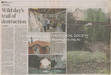 Eltham District Historical Society Inc
Newsclipping, Reid Sexton, Wild day's trail of destruction, The Age, Tuesday, December 27, pp4-5, 2011
... A flash flood occurred from significant rain fall and hail, which accumulated along an old waterway with floodwater submerging cars along Valonia Drive then down Grove Street flooding houses, through the Bible Street Reserve where it then submerged Main Road washing away the small railway trestle bridge opposite the reserve then flooding the Judge Book Village before finally entering the Diamond Creek. ...A flash flood occurred from significant rain fall and hail, which accumulated along an old waterway with floodwater submerging cars along Valonia Drive then down Grove Street flooding houses, through the Bible Street Reserve where it then submerged Main Road washing away the small railway trestle bridge opposite the reserve then flooding the Judge Book Village before finally entering the Diamond Creek. ...A late afternoon storm on Christmas Day 2011. A flash flood occurred from significant rain fall and hail, which accumulated along an old waterway with floodwater submerging cars along Valonia Drive then down Grove Street flooding houses, through the Bible Street Reserve where it then submerged Main Road washing away the small railway trestle bridge opposite the reserve then flooding the Judge Book Village before finally entering the Diamond Creek. Widespread damage occured from hail and flash flooding.fay bridge collection, eltham, 2011-12-27, flood damage, floods, floodwater -
 Eltham District Historical Society Inc
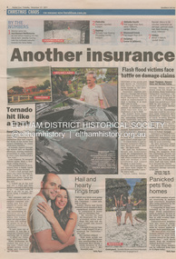
Newsclipping, Angus Thompson et al, Another insurance storm brews, Herald Sun, Tuesday, December 27, pp4-5, 2011
... A flash flood occurred from significant rain fall and hail, which accumulated along an old waterway with floodwater submerging cars along Valonia Drive then down Grove Street flooding houses, through the Bible Street Reserve where it then submerged Main Road washing away the small railway trestle bridge opposite the reserve then flooding the Judge Book Village before finally entering the Diamond Creek. ...A flash flood occurred from significant rain fall and hail, which accumulated along an old waterway with floodwater submerging cars along Valonia Drive then down Grove Street flooding houses, through the Bible Street Reserve where it then submerged Main Road washing away the small railway trestle bridge opposite the reserve then flooding the Judge Book Village before finally entering the Diamond Creek. ...A late afternoon storm on Christmas Day 2011. A flash flood occurred from significant rain fall and hail, which accumulated along an old waterway with floodwater submerging cars along Valonia Drive then down Grove Street flooding houses, through the Bible Street Reserve where it then submerged Main Road washing away the small railway trestle bridge opposite the reserve then flooding the Judge Book Village before finally entering the Diamond Creek. Widespread damage occured from hail and flash flooding.fay bridge collection, eltham, 2011-12-27, flood damage, floods, floodwater -
 Eltham District Historical Society Inc
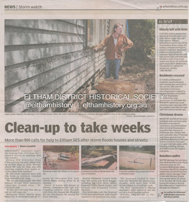
Newsclipping, Shaun Campbell, Clean-up to take weeks, Diamond Valley Leader, December 2011
... A flash flood occurred from significant rain fall and hail, which accumulated along an old waterway with floodwater submerging cars along Valonia Drive then down Grove Street flooding houses, through the Bible Street Reserve where it then submerged Main Road washing away the small railway trestle bridge opposite the reserve then flooding the Judge Book Village before finally entering the Diamond Creek. ...A flash flood occurred from significant rain fall and hail, which accumulated along an old waterway with floodwater submerging cars along Valonia Drive then down Grove Street flooding houses, through the Bible Street Reserve where it then submerged Main Road washing away the small railway trestle bridge opposite the reserve then flooding the Judge Book Village before finally entering the Diamond Creek. ...A late afternoon storm on Christmas Day 2011. A flash flood occurred from significant rain fall and hail, which accumulated along an old waterway with floodwater submerging cars along Valonia Drive then down Grove Street flooding houses, through the Bible Street Reserve where it then submerged Main Road washing away the small railway trestle bridge opposite the reserve then flooding the Judge Book Village before finally entering the Diamond Creek. Widespread damage occured from hail and flash flooding.fay bridge collection, eltham, flood damage, floods, floodwater -
 Eltham District Historical Society Inc
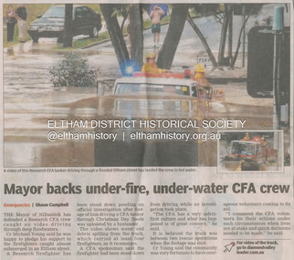
Newsclipping, Shaun Campbell, Mayor backs under-fire, under-water CFA crew, Diamond Valley Leader, December 2011
... A flash flood occurred from significant rain fall and hail, which accumulated along an old waterway with floodwater submerging cars along Valonia Drive then down Grove Street flooding houses, through the Bible Street Reserve where it then submerged Main Road washing away the small railway trestle bridge opposite the reserve then flooding the Judge Book Village before finally entering the Diamond Creek. ...A flash flood occurred from significant rain fall and hail, which accumulated along an old waterway with floodwater submerging cars along Valonia Drive then down Grove Street flooding houses, through the Bible Street Reserve where it then submerged Main Road washing away the small railway trestle bridge opposite the reserve then flooding the Judge Book Village before finally entering the Diamond Creek. ...A late afternoon storm on Christmas Day 2011. A flash flood occurred from significant rain fall and hail, which accumulated along an old waterway with floodwater submerging cars along Valonia Drive then down Grove Street flooding houses, through the Bible Street Reserve where it then submerged Main Road washing away the small railway trestle bridge opposite the reserve then flooding the Judge Book Village before finally entering the Diamond Creek. Widespread damage occured from hail and flash flooding.fay bridge collection, eltham, flood damage, floods, floodwater, main road, research fire brigade