Showing 6 items matching "surface geology plan"
-
 Clunes Museum
Map, Surface Geology Plan
... Surface Geology Plan......surface geology plan...Clunes Museum 36 Fraser Street enter building through Collins Place Clunes goldfields Plans show various shaft locations north broken hill ltd surface geology plan .1 C-21 North Broken Hill Ltd Clunes Block 23/19 .2SOUTH CLUNES MINE Ltd Clunes Block 19/19 .1 Photocopy of Plan Block 23/19 Scale 1 inch = 100 feet .2 Photocopy of Plan Block 19/19 Scale 1 inch = 100 feet .3 AERIAL PHOTOGRAPH WITH WORKINGS MARKED - LAMINATED Surface Geology Plan Map MAP ...Plans show various shaft locations.1 Photocopy of Plan Block 23/19 Scale 1 inch = 100 feet .2 Photocopy of Plan Block 19/19 Scale 1 inch = 100 feet .3 AERIAL PHOTOGRAPH WITH WORKINGS MARKED - LAMINATED.1 C-21 North Broken Hill Ltd Clunes Block 23/19 .2SOUTH CLUNES MINE Ltd Clunes Block 19/19north broken hill ltd, surface geology plan -
 Bendigo Historical Society Inc.
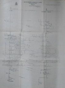
Map - UNITED HUSTLER'S & REDAN & K. K. MINES - PLAN OF THE UNITED HUSTLER'S & REDAN & K. K. MINES
... Plan of the United Hustler's & Redan & K. K. Mines Bulletin No 33 Plate No XXXI. Shows depth of levels, Probable positions of reefs and natural surface with the poppet legs at the two shafts. Sill of shaft of the K. K. Mine 773.56 ft above Sea Level and sill of shaft of the United Hustler's & Redan Mine 745.62 above Sea Level. Also mentioned is the average amount of gold obtained per ton. Note on the top of page - Plates 4, 8, 13, 20, 26 & 31 form a Longitudinal Section from Fortuna Hustler's to Hustler's Consols Mine. Geological...Mines Geological Survey of Victoria H S Whitelaw Underground Survey Office Bendigo Plan of the United Hustler's & Redan & K. K. Mines Bulletin No 33 Plate No XXXI. Shows depth of levels, Probable positions of reefs and natural surface ...Plan of the United Hustler's & Redan & K. K. Mines Bulletin No 33 Plate No XXXI. Shows depth of levels, Probable positions of reefs and natural surface with the poppet legs at the two shafts. Sill of shaft of the K. K. Mine 773.56 ft above Sea Level and sill of shaft of the United Hustler's & Redan Mine 745.62 above Sea Level. Also mentioned is the average amount of gold obtained per ton. Note on the top of page - Plates 4, 8, 13, 20, 26 & 31 form a Longitudinal Section from Fortuna Hustler's to Hustler's Consols Mine. Geological Survey of Victoria emblem and signed by H S Whitelaw, Underground Survey Office, Bendigo, September 1913. mining, parish map, united hustler's & redan & k. k. mines, geological survey of victoria, h s whitelaw, underground survey office bendigo -
 Bendigo Historical Society Inc.
Map - GREAT EXTENDED HUSTLER'S MINE - TRANSVERSE SECTION OF THE GREAT EXTENDED HUSTLER'S MINE
... Shows Poppet legs at the surface and Sill of Shaft at 788.99 feet above Sea Level, Cross Cuts and their depths, stone and geographical features encountered and their references and a number of enlarged drawing of sections of the crosscuts, Geological Survey of Victoria emblem and signed by H A Whitelaw, Underground Survey Office Bendigo, September 1913. The depths of crosscuts to No 21 were taken from plans...Geological Survey of Victoria Underground Survey Office Bendigo H A Whitelaw Transverse Section of the Great Extended Hustler's Mine on the Hustler's Line of Reef. Bulletin No 33, Plate No XII. Shows Poppet legs at the surface and Sill of Shaft at 788.99 feet above Sea Level, Cross Cuts and their depths, stone and geographical features encountered and their references and a number of enlarged drawing of sections of the crosscuts, Geological Survey of Victoria emblem and signed by H A Whitelaw, Underground Survey Office Bendigo, September 1913. The depths of crosscuts to No 21 were taken from plans ...Transverse Section of the Great Extended Hustler's Mine on the Hustler's Line of Reef. Bulletin No 33, Plate No XII. Shows Poppet legs at the surface and Sill of Shaft at 788.99 feet above Sea Level, Cross Cuts and their depths, stone and geographical features encountered and their references and a number of enlarged drawing of sections of the crosscuts, Geological Survey of Victoria emblem and signed by H A Whitelaw, Underground Survey Office Bendigo, September 1913. The depths of crosscuts to No 21 were taken from plans of surveys by Mr. Walker and Mr. Craven, noted under Reference. Another note: This Saddle Reef is sketched from Mr. Walker's plan. Dividends amounting to 360,000 pounds were obtained from it. mining, parish map, great extended hustler's mine, transverse section of the great extended hustler's mine, old shaft, mr walker, mr craven, geological survey of victoria, underground survey office bendigo, h a whitelaw -
 Bendigo Historical Society Inc.
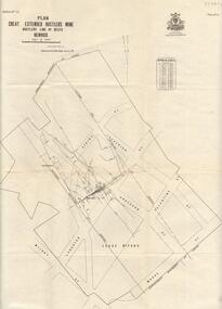
Map - GREAT EXTENDED HUSTLER'S MINE - PLAN OF THE GREAT EXTENDED HUSTLER'S MINE
... Plan has map of streets. Mine was located in the block bounded by Langston and Anderson Streets and was between the Hustler's Anticline at Surface and the Lightning Hill Anticline at Surface. Latham & Watson's Shaft is also mentioned. Levels are numbered and a table shows the Levels and their Depths. Geological...History House 11 Mackenzie Street Bendigo goldfields MINING Parish Map Great Extended Hustler's Mine Hustler's Line of Reefs Mining Lease No 7382 Geological Survey of Victoria Underground Survey Office Bendigo H A Whitelaw Latham & Watson's Shaft Plan of the Great Extended Hustler's Mine on the Hustler's Line of Reefs, Bendigo. Bulletin No 33, Plate No X. Lease No 7382. Plan has map of streets. Mine was located in the block bounded by Langston and Anderson Streets and was between the Hustler's Anticline at Surface ...Plan of the Great Extended Hustler's Mine on the Hustler's Line of Reefs, Bendigo. Bulletin No 33, Plate No X. Lease No 7382. Plan has map of streets. Mine was located in the block bounded by Langston and Anderson Streets and was between the Hustler's Anticline at Surface and the Lightning Hill Anticline at Surface. Latham & Watson's Shaft is also mentioned. Levels are numbered and a table shows the Levels and their Depths. Geological Survey of Victoria. Signed by H A Whitelaw, Underground Survey Office, Bendigo, September 1913. This item has not been scanned or photographed.mining, parish map, great extended hustler's mine, hustler's line of reefs, mining lease no 7382, geological survey of victoria, underground survey office bendigo, h a whitelaw, latham & watson's shaft -
 Federation University Historical Collection
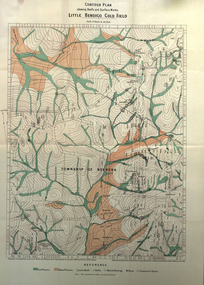
Book, Report on the Little Bendigo or Nerrena Gold-Field, Ballarat, 1901, 1901
... Barker Library (top floor) Mount Helen goldfields little bendigo nerrena h.s. whitelaw william baragwanath geology monte christo monte cristo neerena nerrina plans mining cgt Blue soft covered foolscap book of 4 pages. The book includes a folded, colour contour plan shewing reefs and Surface Works Little Bendigo Gold Field and an Underground Survey of Mines, Metropolitan, Monte Cristo Line Report on the Little Bendigo or Nerrena Gold-Field, Ballarat, 1901 Book Robert Brain, Government Printer ...Blue soft covered foolscap book of 4 pages. The book includes a folded, colour contour plan shewing reefs and Surface Works Little Bendigo Gold Field and an Underground Survey of Mines, Metropolitan, Monte Cristo Linelittle bendigo, nerrena, h.s. whitelaw, william baragwanath, geology, monte christo, monte cristo, neerena, nerrina, plans, mining cgt -
 Federation University Historical Collection
Book, Bennett H. Brough, A treatise on Mine-Surveying, 1904
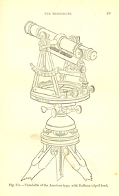
... geological society and of the Institute of Chemistry, a member of the Mining Institute of Cornwall, and a former instructor of mine-surveying at the Royal School of Mines mining surveying miner's dial chain survey theodolite scientific instruments Red had covered book 372 pages - part of Griffin's Mining Series. Contents include general explanatinos of surveying, an historical sketch, mineral deposits, mining terms, measures of length, measurement distances, the chain, rods, steel bands, measuring wheel, Miner's Dial, Magnetic needle, Fixed needle, German Dial, theodolite, traversing underground. Surface-surveys. plotting the survey, calculation of area, leveling, Telescope, Setting out, Mine-Surveying Problems, Mine Plans ...The author, Bennett H. Brough was an associate of theRoyal School of Mines, a member of the COuncil of the Institution of Mining Engineers, a fellow of the geological society and of the Institute of Chemistry, a member of the Mining Institute of Cornwall, and a former instructor of mine-surveying at the Royal School of MinesRed had covered book 372 pages - part of Griffin's Mining Series. Contents include general explanatinos of surveying, an historical sketch, mineral deposits, mining terms, measures of length, measurement distances, the chain, rods, steel bands, measuring wheel, Miner's Dial, Magnetic needle, Fixed needle, German Dial, theodolite, traversing underground. Surface-surveys. plotting the survey, calculation of area, leveling, Telescope, Setting out, Mine-Surveying Problems, Mine Plans, Photographic Surveying, examination Surveying. Illustrations include: Whitelaw's Dial (Fig 22), Theodolite of the American Type with Hoffman tripod head, (fig 37a)mining, surveying, miner's dial, chain, survey, theodolite, scientific instruments