Showing 9 items matching "survey map snowy-river"
-
 Orbost & District Historical Society
survey, 1941
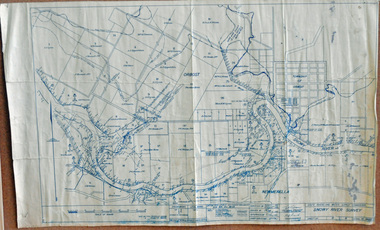
... survey map Snowy-River...A survey map produced by the State Rivers and Water Supply Commission. It is on white paper with blue ink. It is a hand-drawn survey of the Snowy River in 1939-40....Orbost & District Historical Society Ruskin Street Orbost gippsland this item is a useful reference tool. survey map Snowy-River A survey map produced by the State Rivers and Water Supply Commission. ...this item is a useful reference tool.A survey map produced by the State Rivers and Water Supply Commission. It is on white paper with blue ink. It is a hand-drawn survey of the Snowy River in 1939-40.survey map snowy-river -
 Bendigo Military Museum
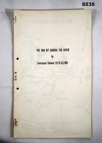
Journal - Royal Australian Survey Corps - The Bad Bit Across the River - LtCol HPG Clews 1934, LTCol HPG Clews RASvy, 1934
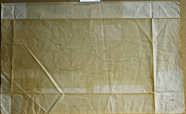
... Snowy Mountains Authority from 1950-1958. A Survey Cairn is errected in Khancoban to record his life 1890 - 1980. This Journal records the field trip to establish Survey Control in very rugged country by a handful of party members on foot. The map shows the routes taken. Royal Australian Survey Corps RASvy Fortuna Army Survey Regiment Army Svy Regt ASR 2nd Field Survey Company 14 x foolscap pages stapled and two hole punched. The Journal includes a map, 7 x pages of typed text and 4 x Annexes Royal Australian Survey Corps - The Bad Bit Across the River ...This Journal "The bad bit across the River" was written by - LtCol HPG Clews in 1934 and is about his experiences around the Colo River approximately 60 miles NW of Sydney, NSW. LtCol Clews was a remarkable man and his achievements were just as remarkable. He is affectionately known as "The Major." He served in the British Army 1909 - 1911 with the Sherwood Foresters. He then served in the Royal Australian Survey Corps from 1912 - 1949 and then served as the Senior Surveyor with the Snowy Mountains Authority from 1950-1958. A Survey Cairn is errected in Khancoban to record his life 1890 - 1980. This Journal records the field trip to establish Survey Control in very rugged country by a handful of party members on foot. The map shows the routes taken.14 x foolscap pages stapled and two hole punched. The Journal includes a map, 7 x pages of typed text and 4 x Annexesroyal australian survey corps, rasvy, fortuna, army survey regiment, army svy regt, asr, 2nd field survey company -
 Orbost & District Historical Society
survey sheet, circa 1870's
... This map is a useful reference tool. survey Bruce-E.L Snowy-River-C19th Gipps Land Rivers No 32B E.L. ...E.L. Bruce, born in Ireland on July 1,1854, came to Australia in 1854 and joined the Lands Department. He spent most of his service in Gippsland. The journey to Sale then was made by ship to Port Albert and thence on horseback. He began his service in Gippsland as assistant district surveyor and for the last 12 years before retirement he was district surveyor and land officer. His territory extended from the boundary of Victoria in east Gippsland down to Wilson's Promontory with his headquarters at sale.This map is a useful reference tool.A survey map - Sheet No 3 SnowyRiver Survey. This is a copy of the original survey. It shows the properties of W.J.T. Clarke - two in Orbost and one in Newmeralla (sic),. it has a faded, undecipherable red stamp in the bottom right corner.Gipps Land Rivers No 32B E.L. Brucesurvey bruce-e.l snowy-river-c19th -
 Orbost & District Historical Society
map/brochure, Discovering Marlo & The Snowy River Estuary, December 1988
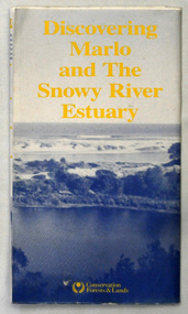
... Survey, the Department of State Forests and the Ministry for Conservation. This brochure/map was used as tourist information in Orbost. This item is a useful research tool. map brochure snowy-river marlo A folded map/brochure titled "DISCOVERING MARLO & THE SNOWY RIVER ESTUARY". ...In 1983 the Department of Conservation, Forests and Lands replaced the Department of Crown Lands and Survey, the Department of State Forests and the Ministry for Conservation. This brochure/map was used as tourist information in Orbost.This item is a useful research tool.A folded map/brochure titled "DISCOVERING MARLO & THE SNOWY RIVER ESTUARY". On the front is a photograph of Marlo and the title in yellow print. There is a locality map for access to Corringle beach and the brochure Includes a key to fishing sites and various tourist locations. On the back of the brochure are notes on fishing, wildlife and a boating guide, map brochure snowy-river marlo -
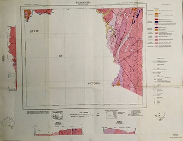 Federation University Historical Collection
Map - Geological, Tallangatta, New South Wales: 1:250,000 Geological Series, SJ 55-3, 1966, 1966
... Survey of N.S.W., Division of Regional Geology. Topographical base compiled from Snowy Mountains Hydro Electrical Authority, Department of Lands, County maps and Snowy Lease Map. Other sheet adjoin this map. There are 13 formation sections grouped into 9 - Quaternary, Tertiary, Middle Devonian, Lower to Middle Devonian, Lower Devonian, Upper Silurian, Silurian, Upper Ordovician and Ordovician. tallangatta new south wales geological survey topographical base snowy mountains hydro electrical authority department of lands snowy lease map department of mines quaternary tertiary middle devonian lower to middle devonian lower devonian uper siluran silurian upper ordovician ordovician Scale of map, longitude and latitude, river names. ...Compiled by the Geological Survey of N.S.W., Division of Regional Geology. Topographical base compiled from Snowy Mountains Hydro Electrical Authority, Department of Lands, County maps and Snowy Lease Map. Other sheet adjoin this map. There are 13 formation sections grouped into 9 - Quaternary, Tertiary, Middle Devonian, Lower to Middle Devonian, Lower Devonian, Upper Silurian, Silurian, Upper Ordovician and Ordovician.Large coloured map showing geological features, faults, bores, rivers and mineral deposits.Scale of map, longitude and latitude, river names. "Tallangatta 1:250,00" written in black pen.tallangatta, new south wales, geological survey, topographical base, snowy mountains hydro electrical authority, department of lands, snowy lease map, department of mines, quaternary, tertiary, middle devonian, lower to middle devonian, lower devonian, uper siluran, silurian, upper ordovician, ordovician -
 Lakes Entrance Historical Society
Map - Inceecoobee County of Tambo, Department of Lands and Survey, 7/6/2016
... Lakes Entrance Historical Society 4 Marine Parade Lakes Entrance gippsland Land Settlement Waterways Snowy River, Land owners E A Comors, C H Rogers, Tooncinbooka Map Inceecoobee County of Tambo Department of Lands and Survey ...Snowy River, Land owners E A Comors, C H Rogers, Tooncinbookaland settlement, waterways -
Lakes Entrance Historical Society
Map - Newmerella County of Tambo Sheet 2, Dept. of Land and Survey, September 1951
... Lakes Entrance Historical Society 4 Marine Parade Lakes Entrance gippsland land owners Waterways Map shows land owners Lake Corringle, Snowy River, Bass Strait. Map Newmerella County of Tambo Sheet 2 Dept. of Land and Survey ...Map shows land owners Lake Corringle, Snowy River, Bass Strait.land owners, waterways -
Lakes Entrance Historical Society
Map - Newmerella County of Tambo Sheet 1, Dept of Lands and Survey, September 1951
... Lakes Entrance Historical Society 4 Marine Parade Lakes Entrance gippsland land owners Waterways Map shows land owners, Lake Corringle, Snowy River, Bass Strait Map Newmerella County of Tambo Sheet 1 Dept of Lands and Survey ...Map shows land owners, Lake Corringle, Snowy River, Bass Straitland owners, waterways -
Lakes Entrance Historical Society
Map - Township of Bendoc Parish of Bendock County of Croajingolong, Department of Lands and Survey, 1951
... Waterways Landowners Hydro Electricity Shows Bendock River, Landowners, Land occupied by Snowy Mountains Hydro Electric Authority Map Township of Bendoc Parish of Bendock County of Croajingolong Department of Lands and Survey ...Shows Bendock River, Landowners, Land occupied by Snowy Mountains Hydro Electric Authoritywaterways, landowners, hydro electricity