Showing 88 items matching "surveying tape"
-
 Bendigo Military Museum
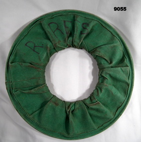
Equipment - Surveying Tape 100m Steel, Circa 1960s
... Surveying Tape 100m Steel...Surveying Tape 100m Steel...These steel Surveying measuring tapes were used by members of the Royal Australian Survey Corps (surveyors and chainmen) for simple short length measurements between points.....1 A 100m steel Surveying measuring tape rolled in a green canvass cover. ...The first 3m replaces a broken section with yellow and red tape. .2 Green Canvas cover to hold the rolled-up steel tape. Surveying Tape 100m Steel Equipment Surveying Tape 100m Steel ...These steel Surveying measuring tapes were used by members of the Royal Australian Survey Corps (surveyors and chainmen) for simple short length measurements between points..1 A 100m steel Surveying measuring tape rolled in a green canvass cover. The tape is 3mm in width. The first 3m replaces a broken section with yellow and red tape. .2 Green Canvas cover to hold the rolled-up steel tape.Labelled "R.REES"royal australian survey corps, rasvy, fortuna, army survey regiment, army svy regt -
 Queenscliffe Maritime Museum
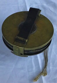
Instrument - Surveying Hydrographic measuring Instrument
... Survey tape used by P.J. Larkin, government surveyor...Survey tape in leather pouch about 100 feet long and housed on brass reel....Queenscliffe Maritime Museum 2 Wharf St Queenscliff geelong-and-the-bellarine-peninsula Survey tape used by P.J. Larkin, government surveyor Instrument owned and used by a government marine surveyor named P. ...Survey tape used by P.J. Larkin, government surveyorInstrument owned and used by a government marine surveyor named P. J. Larkin who worked in Melbourne and Geelong in the 1930s.Survey tape in leather pouch about 100 feet long and housed on brass reel.Purton and Littlejohn's patent Wellington 1663surveying instrument, hydrography, larkin jp -
 Federation University Historical Collection
Instrument, Chesterman, Surveyors Tape, c1900
... surveying tape...Barker Library (top floor) Mount Helen goldfields surveying tape scientific instrument Brass handle one end only, stamped 100 ft. ...Roll of surveyors metal tape with brass handle stamped '100 ft'. Tape marked in 1 inch, 1 foot and 10 foot intervals. Held in roll with leather tie. End broken off (approx 5 feet missing).Brass handle one end only, stamped 100 ft. Tape stamped 'Chesterman Sheffield England'.surveying tape, scientific instrument -
![Survey metal tape on reel with leather bag. 10 yards in length, the metal chain is subdivided every 10 links [2.2 yards].](/media/collectors/4f729f7e97f83e03086018d1/items/5f87f8fd13cca91a6c1db65a/item-media/615a8287eb51660bb8dc9e31/item-fit-380x285.jpg?cb=6) Queenscliffe Maritime Museum
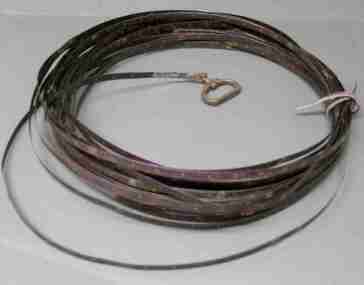
Queenscliffe Maritime MuseumInstrument - Survey tape on metal reel in leather bag with other articles
... Survey tape on metal reel in leather bag with other articles...Survey tape on metal reel in leather bag with other articles: plumb bobs, number pegs, drawing instruments in box and steel punches...Parsons surveying instruments, 215 Queen Street Melbourne Survey tape on metal reel in leather bag with other articles: plumb bobs, number pegs, drawing instruments in box and steel punches Instrument Survey tape on metal reel in leather bag with other articles ...A surveyors chain is actually a thin steel band on a reel and is used for accurate measurements. This 110 yard [101m] chain is subdivided every 10 links [2.2 yards or 2m]Items belonged to J P Larkin Government marine surveyor who worked on surveys up to 1938. He worked in Port Phillip and Queenscliff related surveys [e.g. Western channel, Queenscliff channel].Survey tape on metal reel in leather bag with other articles: plumb bobs, number pegs, drawing instruments in box and steel punchesMade by A.E. Parsons surveying instruments, 215 Queen Street Melbournesurveying equipment, j p larkin -
 Warrnambool and District Historical Society Inc.
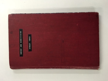
Register, Survey & subdivision street index, 1930s
... Front Cover (in plastic tape): ‘Survey and Subdivision. Street Index’...surveys during that time. It will be very useful for researchers. Warrnambool City Council Warrnambool Streets and Subdivisions Front Cover (in plastic tape): ‘Survey and Subdivision. ...This is a book with the City of Warrnambool surveys and subdivisions listed under the street names. It covers the period from 1938 to 1975. The information is listed under the headings of plan number, street name, section, allotment, date and remarks. The information contained therein would now be held as electronic data in the Council Records Department. Warrnambool, founded in 1847, became a municipality in 1856, a Borough in 1863, a Town in 1883 and a City in 1918. This book is of considerable interest because it lists Warrnambool streets from 1938 to 1975 and gives details of the subdivisions and surveys during that time. It will be very useful for researchers. This is a foolscap-size hard-cover book with a red cover with a mottled-blue pattern paper inside the covers. It has 95 pages with ruled red and blue lines. It has a handwritten alphabet index throughout the pages. The contents are handwritten in blue, green and black ink. The inside binding has been mended with adhesive tape and one page is loose. The book lists subdivisions in the City of Warrnambool under the heading of the street names and covers 1938 to 1975. The cover is somewhat grubby.Front Cover (in plastic tape): ‘Survey and Subdivision. Street Index’warrnambool city council, warrnambool streets and subdivisions -
 Federation University Historical Collection
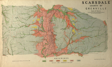
Plan, Scarsdale County of Grenville, 1889, 26/01/1889
... Rectangular plan of a geological survey edged in masking tape. It is predominantly grey, pink and green, but has some yellow. scale is 40 chains to one inch. ...scarsdale grenville krause browns and scarsdale mopianimum watershed yarrowee woady yalloak timber reserve department of mines plans cgt crown lands Ferdinand Krause Rectangular plan of a geological survey edged in masking tape. It is predominantly grey, pink and green, but has some yellow. scale is 40 chains to one inch. ...Rectangular plan of a geological survey edged in masking tape. It is predominantly grey, pink and green, but has some yellow. scale is 40 chains to one inch. (see Cat. No. 1098 for report on the Parish of Scarsdale)scarsdale, grenville, krause, browns and scarsdale, mopianimum, watershed, yarrowee, woady yalloak, timber reserve, department of mines, plans, cgt, crown lands, ferdinand krause -
 Bendigo Military Museum
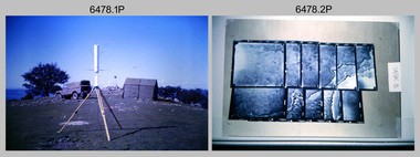
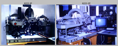
Photograph - Royal Australian Survey Corps - Map Production Processes, c1990
... Survey, Bonegilla, Victoria. .3) – Photo, colour, c1990. Aerotriangulation: Wild PUG4 point transfer device, SSGT Bruce Hammond. .4) – Photo, colour, c1990. Aerotriangulation: Zeiss (Jena) Stecometer, SSGT Bruce Hammond. .5) – Photo, colour, c1990. Aerotriangulation: computer tape...Survey, Bonegilla, Victoria. .3) – Photo, colour, c1990. Aerotriangulation: Wild PUG4 point transfer device, SSGT Bruce Hammond. .4) – Photo, colour, c1990. Aerotriangulation: Zeiss (Jena) Stecometer, SSGT Bruce Hammond. .5) – Photo, colour, c1990. Aerotriangulation: computer tape ...This is a collection of 20 photographs of Royal Australian Survey Corps phases of map production at the School of Military Survey, Bonegilla, the Army Survey Regiment, Bendigo, and the Army Map Depot, Bandiana circa 1990. Colour photos are on 35mm slide film and were scanned at 96 dpi. They are part of the Army Survey Regiment’s Collection. Photo .1P was probably taken on a survey station overlooking Lake Hume near Albury-Wodonga. The field party occupying the survey station was likely from a Map Control Survey course conducted by the School of Military Survey, Bonegilla. This survey station was part of a geodetic network used in field survey training and RASvy’s Lake Hume Test Range. Photos .3P to .16P were taken at the Army Survey Regiment, Bendigo and photos .17P & .18P were taken at the Army Map Depot, Bandiana. Photo .19P depicts a map of RASvy’s ARA units before the disbandment of 5th Field Survey Squadron, Perth and 2nd Field Survey Squadron, Sydney in 1990. This is a collection of 20 photographs of map production processes taken at the School of Military Survey, Bonegilla, the Army Survey Regiment, Bendigo, and the Army Map Depot, Bandiana circa 1990. Colour photos are on 35mm slide film and were scanned at 96 dpi. They are part of the Army Survey Regiment’s Collection. Photo .2P is printed on photographic and scanned at 300 dpi. .1) – Photo, colour, c1980s. Geodetic Surveying: AN/PRR-14 Geoceiver antenna on hill surrounding Lake Hume. Series 3 Land Rover, field party tent and survey station beacon in background. .2) – Photo, black & white, c1980s. Geodetic Surveying: AN/PRR-14 Geoceiver antennas set up at the School of Military Survey, Bonegilla, Victoria. .3) – Photo, colour, c1990. Aerotriangulation: Wild PUG4 point transfer device, SSGT Bruce Hammond. .4) – Photo, colour, c1990. Aerotriangulation: Zeiss (Jena) Stecometer, SSGT Bruce Hammond. .5) – Photo, colour, c1990. Aerotriangulation: computer tape maintenance, SSGT Noel McNamara. .6) – Photo, colour, c1990. AUTOMAP 2: computer tape maintenance, SPR Nadine (Paul) Read. .7) - Photo, colour, c1990s. AUTOMAP 2: Optronics 4040 scanning/film output in Lithographic Squadron, SGT Sherri (Dally) Burke. .8) - Photo, colour, c1990s. AUTOMAP 2: Benson verification plotter output, SPR Nadine (Paul) Read. .9) – Photo, colour, c1990. Aerotriangulation: data management, SGT Neil ‘Ned’ Kelly. .10) & .11) - Photo, colour, c1990s. AUTOMAP 2: Wild B8 Aviograph stereoplotter Feature Extraction, unidentified technician. .12) - Photo, colour, c1990s. AUTOMAP 2: Graphic Edit Workstation, SPR Nadine (Paul) Read. .13) - Photo, colour, c1990s. AUTOMAP 2: Graphic Edit Workstation, SPR Dawn Hoadley. .14) & .15) - Photo, colour, c1990s. AUTOMAP 2: Graphic Edit Workstation, unidentified technician. .16) – Photo, colour, c1990s. Heidelberg Speedmaster 102 computer-controlled five colour lithographic offset printing press. .17) & .18) – Photo, colour, c1990s. Army Map Depot, unidentified storeman, Bandiana. .19) – Photo, colour, c1990. RASvy ARA Unit Locations before disbandment of field units in Perth and Sydney. .20) – Photo, colour, c1990. Set of overlapping aerial photography..1P, .3P to .20P - Some equipment is identified on the frame of the 35mm slides.royal australian survey corps, rasvy, army survey regiment, army svy regt, fortuna, asr, school of military survey, army map depot -
 Bendigo Military Museum
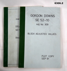
Administrative record - Report on the Block Adjustment of the Gordon Downs and Delemere 1:250,000 Maps, Army Survey Regiment, 1 Sep 1991, .2 Jan 1988
... Royal Australian Survey Corps RASvy Fortuna Army Survey Regiment Army Svy Regt ASR .1 Blue covered booklet with green tape binding. ...All mapping produced at this time were produced using Aerial Photography. These booklets contain the adjusted mathematical solution to joining this group of photographs together..1 Blue covered booklet with green tape binding. Block adjusted values for Gordon Downs SE 52-10 1:250 000 map Adjustment number 309 Sep 1991 .2 Blue covered booklet with green tape binding. Block adjusted values for Delamere SD 52-16 1:250 000 map Adjustment number 272 Jan 1988royal australian survey corps, rasvy, fortuna, army survey regiment, army svy regt, asr -
 Kiewa Valley Historical Society
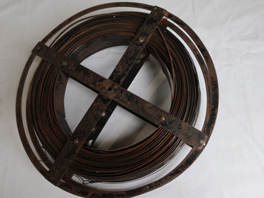
Surveyors Chain - Steel Band
... survey of the public lands as prescribed by law. In Australia most building lots in the past were a quarter of an acre, measuring one chain by two and a half chains. Also street frontages, roads, laneways. The chain also survives as the length of a cricket pitch, being the distance between the stumps. Surveyors and residents of the Kiewa Valley used the Steel Band Surveyors Chain to measure distances when developing the land. surveyors surveyors chain measurement of distance Surveyors' steel band measuring tape ...A chain is a unit of length equal to 66 feet or 22 yards. This is a statute measure in the United Kingdom. One link is 100th part of a chain, which is 7.92 inches (20.1 cm). The chain and link became standard surveyors' units of length and crossed to the colonies from the United Kingdom. The chain is the unit of linear measurement for the survey of the public lands as prescribed by law. In Australia most building lots in the past were a quarter of an acre, measuring one chain by two and a half chains. Also street frontages, roads, laneways. The chain also survives as the length of a cricket pitch, being the distance between the stumps. Surveyors and residents of the Kiewa Valley used the Steel Band Surveyors Chain to measure distances when developing the land.Surveyors' steel band measuring tape, known as a 'standard band', or a 'steel band chain'.This chain consists of a long narrow strip of steel of uniform width of 3 mm and thickness of 0.3 to 0.6 mm. The chain itself is between 20 m and 30 m long.surveyors, surveyors chain, measurement of distance -
 Bendigo Military Museum
Photograph - AUTOMAP 2 Production - Army Survey Regiment, Fortuna, Bendigo, c1986
... They are part of the Army Survey Regiment’s Collection. .1) - Photo, colour, c1986, AUTOMAP 2 Production - Army Survey Regiment, Fortuna, Bendigo. c1986. .2) - Photo, colour, c1986, AUTOMAP 2 Wild B8 Aviograph stereoplotter. .3) - Photo, colour, c1986, AUTOMAP 2 Wild B8 Aviograph stereoplotter feature extraction, unidentified technician. .4) - Photo, colour, c1986, Wild B8 Aviograph stereoplotter feature extraction, LCPL Raelene (Munting) Brodie. .5) - Photo, colour, c1986, AUTOMAP 2 computer tape maintenance, SPR Steve Linane. .6) - Photo, colour, c1986, AUTOMAP 2 Graphic Edit Workstation, SPR Steve Linane. .7) to .8) - Photo, colour, c1986, AUTOMAP 2 Graphic Edit Workstation, unidentified technician. .9 to .10) - Photo, colour, c1986, AUTOMAP 2 Graphic Edit Workstation. .11) - Photo, colour, c1986, AUTOMAP 2 Graphic Edit Workstation feature coding and command menu. .12) - Photo, colour, c1986, AUTOMAP 2 high resolution computer monitor. .13) to .16) - Photo, colour, c1986, AUTOMAP 2 production output comparison to AUTOMAP 1. .17) to .18) - Photo, colour, c1986, AUTOMAP 2 computer system components. .19) - Photo, colour, c1986, AUTOMAP 2 Intergraph 7596 verification plotter. .20) - Photo, colour, c1986, AUTOMAP 2 Benson verification plotter, SPR Steve Coulson. .21) - Photo, colour, c1986, AUTOMAP 2 drainage, contour, roads and cultural digital data verification plot. .22) - Photo, colour, c1986, AUTOMAP 2 drainage, contour, roads and cultural digital data on computer monitor. .23) - Photo, colour, c1986, AUTOMAP 2 3D digital terrain model on computer monitor. ...They are part of the Army Survey Regiment’s Collection. .1) - Photo, colour, c1986, AUTOMAP 2 Production - Army Survey Regiment, Fortuna, Bendigo. c1986. .2) - Photo, colour, c1986, AUTOMAP 2 Wild B8 Aviograph stereoplotter. .3) - Photo, colour, c1986, AUTOMAP 2 Wild B8 Aviograph stereoplotter feature extraction, unidentified technician. .4) - Photo, colour, c1986, Wild B8 Aviograph stereoplotter feature extraction, LCPL Raelene (Munting) Brodie. .5) - Photo, colour, c1986, AUTOMAP 2 computer tape maintenance, SPR Steve Linane. .6) - Photo, colour, c1986, AUTOMAP 2 Graphic Edit Workstation, SPR Steve Linane. .7) to .8) - Photo, colour, c1986, AUTOMAP 2 Graphic Edit Workstation, unidentified technician. .9 to .10) - Photo, colour, c1986, AUTOMAP 2 Graphic Edit Workstation. .11) - Photo, colour, c1986, AUTOMAP 2 Graphic Edit Workstation feature coding and command menu. .12) - Photo, colour, c1986, AUTOMAP 2 high resolution computer monitor. .13) to .16) - Photo, colour, c1986, AUTOMAP 2 production output comparison to AUTOMAP 1. .17) to .18) - Photo, colour, c1986, AUTOMAP 2 computer system components. .19) - Photo, colour, c1986, AUTOMAP 2 Intergraph 7596 verification plotter. .20) - Photo, colour, c1986, AUTOMAP 2 Benson verification plotter, SPR Steve Coulson. .21) - Photo, colour, c1986, AUTOMAP 2 drainage, contour, roads and cultural digital data verification plot. .22) - Photo, colour, c1986, AUTOMAP 2 drainage, contour, roads and cultural digital data on computer monitor. .23) - Photo, colour, c1986, AUTOMAP 2 3D digital terrain model on computer monitor. ...This collection of 23 photos of map production on the AUTOMAP 2 computer-based system in Air Survey and Cartographic Squadrons, was most likely taken in 1986. The AUTOMAP 2 system was an upgrade to the AUTOMAP 1 system, comprising Intergraph graphic edit workstation terminals networked to VAX 750/785 main frame computers. Unlike AUTOMAP 1, operators could display digital topographic features on monitors for editing. Successful adaptation of this system meant RASvy was at the forefront of digital mapping/cartographic systems in Australia and overseas. The system comprised Input (Wild B8 Aviograph feature extraction) Raster Scanning (digitising from compilation sheets, Graphic Edit (cartographic completion) and Plot Verification Sub Systems. The system was operational from 1984 to its ‘Newheart’ upgrade in 1993. Throughout its life, the system was progressively refined with productivity gains, achieved from award winning technical development in-house by talented and innovative Army Survey Regiment personnel.This is a set of 23 photograph of AUTOMAP 2 production at the Army Survey Regiment at Fortuna, Bendigo, c1986. The photographs were on 35mm colour slides and were scanned at 96 dpi. Photos .5P and .6P are also printed on photographic and scanned at 300 dpi. They are part of the Army Survey Regiment’s Collection. .1) - Photo, colour, c1986, AUTOMAP 2 Production - Army Survey Regiment, Fortuna, Bendigo. c1986. .2) - Photo, colour, c1986, AUTOMAP 2 Wild B8 Aviograph stereoplotter. .3) - Photo, colour, c1986, AUTOMAP 2 Wild B8 Aviograph stereoplotter feature extraction, unidentified technician. .4) - Photo, colour, c1986, Wild B8 Aviograph stereoplotter feature extraction, LCPL Raelene (Munting) Brodie. .5) - Photo, colour, c1986, AUTOMAP 2 computer tape maintenance, SPR Steve Linane. .6) - Photo, colour, c1986, AUTOMAP 2 Graphic Edit Workstation, SPR Steve Linane. .7) to .8) - Photo, colour, c1986, AUTOMAP 2 Graphic Edit Workstation, unidentified technician. .9 to .10) - Photo, colour, c1986, AUTOMAP 2 Graphic Edit Workstation. .11) - Photo, colour, c1986, AUTOMAP 2 Graphic Edit Workstation feature coding and command menu. .12) - Photo, colour, c1986, AUTOMAP 2 high resolution computer monitor. .13) to .16) - Photo, colour, c1986, AUTOMAP 2 production output comparison to AUTOMAP 1. .17) to .18) - Photo, colour, c1986, AUTOMAP 2 computer system components. .19) - Photo, colour, c1986, AUTOMAP 2 Intergraph 7596 verification plotter. .20) - Photo, colour, c1986, AUTOMAP 2 Benson verification plotter, SPR Steve Coulson. .21) - Photo, colour, c1986, AUTOMAP 2 drainage, contour, roads and cultural digital data verification plot. .22) - Photo, colour, c1986, AUTOMAP 2 drainage, contour, roads and cultural digital data on computer monitor. .23) - Photo, colour, c1986, AUTOMAP 2 3D digital terrain model on computer monitor. .1P to .23P - Some of the equipment is annotated on the frame of the 35mm slides. .5P & .6P prints annotated incorrectly ‘Steve Lenane’. Correct spelling is - ‘Steve Linane’ royal australian survey corps, rasvy, army survey regiment, army svy regt, fortuna, asr, automap 2 -
 Bendigo Military Museum
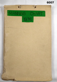
Document - Army Survey Regiment Manning Chart 1976, 1976
... Survey Regiment. Pages are fixed to the folder by a metal fastener. The title of the folder is written in black ink on a green tape background....Survey Regiment. Pages are fixed to the folder by a metal fastener. The title of the folder is written in black ink on a green tape background. ...This document contains detailed photocopies of reports of Army Survey Regiment’s staff manning from December 1975 to August 1976. Each monthly report provided to Directorate of Survey covered the allocation of staff to Regimental Headquarters and its four sub units comprising Headquarters, Air Survey (Topographic), Cartographic and Lithographic Squadrons. Each Squadron’s troop or section structure was represented by a wire diagram with soldiers and/or civilians names assigned to rank based established positions. A detailed table at the end of each report sumarised Army Survey Regiment’s posted strength by employment category and rank.Manilla cardboard folder containing 83 photocopied pages of staff posted to the Army Survey Regiment. Pages are fixed to the folder by a metal fastener. The title of the folder is written in black ink on a green tape background.royal australian survey corps, rasvy, army survey regiment, army svy regt, asr, fortuna -
 Bendigo Military Museum
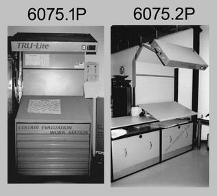
Photograph - Equipment used in Map Production at the Army Survey Regiment, 1991
... tape. As most map type (letters and names) generation was done in Automap 2, The ITEK Typesetter shown in photo .9P was close to obsolete in 1991. At this time it was used to generate map type for other RASvy units, contractors and sections still performing manual map production at Army Svy Regt. Royal Australian Survey ...These nine photographs of technical equipment were provided to the Directorate of Survey as input to the 1990-1991 Annual Report. The equipment in Photos .1P and .2P were used to evaluate/validate colour values on printed maps. The equipment in Photo .3P is a daylight film processor. The Optronix 5040 Laser Scanner/Plotter was shown in Photos .4P to .6P. The Print Room’s Map Handling Station in photo .7P provided ergonomic benefits to the Printer Technician and improved despatching productivity. The Optical Disk Archive and Retrieval System (ODARS) equipment in .8P was optical "platter" disk technology for the secure and long term archive storage of large amounts of digital map data. Map data was transferred from large reels of magnetic tape. As most map type (letters and names) generation was done in Automap 2, The ITEK Typesetter shown in photo .9P was close to obsolete in 1991. At this time it was used to generate map type for other RASvy units, contractors and sections still performing manual map production at Army Svy Regt.This is a set of photographs of Army Survey Regiment technical equipment taken in 1991. The photographs were printed on photographic paper and are part of the Army Survey Regiment’s Collection. The photographs were scanned at 300 dpi. .1) - Photo, black & white, 1991, Colour Evaluation Workstation No 1, Lithographic Squadron .2) - Photo, black & white, 1991, Colour Evaluation Workstation No 2, Lithographic Squadron .3) - Photo, black & white, 1991, Daylight film processor, Lithographic Squadron, Daylight Working Contacting Frames in background. .4) - Photo, black & white, 1991, Optronix 5040 Laser Scanner/Plotter, Lithographic Squadron .5) - Photo, black & white, 1991, Optronix 5040 Laser Scanner/Plotter, Lithographic Squadron .6) - Photo, black & white, 1991, Optronix 5040 Laser Scanner/Plotter, Lithographic Squadron .7) - Photo, black & white, 1991, Map Handling Station, Lithographic Squadron .8) - Photo, black & white, 1991, Optical Disk Archive and Retrieval System (ODARS), Cartographic Squadron .10) - Photo, black & white, 1991, Optronix 5040 Laser Scanner/Plotter, Lithographic Squadron .9) - Photo, black & white, 1991, ITEK Typesetter, Cartographic Squadron.1P, .2P, .4P to .10P – equipment description annotated on back .3P - no annotation.royal australian survey corps, rasvy, army survey regiment, army svy regt, fortuna, asr, litho, automap -
 Bendigo Military Museum
Equipment - AIR CAMERA ACCESSORY, Williamson Mfg. Co. Ltd
... survey work in PNG, Indonesia, Malaysia and Sumatra and the Australian mainland. This type of camera was used in Spitfires, Mosquitos, Avro Lincolns and Canberra aircraft. Aviation Reconnaisance Camera Photography There is a tape ...This Gear box universal, with its Cone assembly ( inc lens) in conjunction with Magazine 500 exposures unit ( see CAT 5561) is part of the F22 aerial camera assembly. As an assembly, the type F22 aerial camera came into RAF and RAAF service c1942. It was used by the RAF over Europe and by the RAAF extensively through the Sth. West Pacific area of operations, during WW2. This type of camera was used through the Vietnam war up to the early 1980's. The F22 camera assembly when mounted in the reliable Canberra aircraft, did aerial survey work in PNG, Indonesia, Malaysia and Sumatra and the Australian mainland. This type of camera was used in Spitfires, Mosquitos, Avro Lincolns and Canberra aircraft.Heavy, metal construction. The base is a rectangular box shape and mounted to that is a funnel shaped tube. Inside the tube are numerous small baffles around the sides painted matte black. The box has a 7 pin electrical connector. The box section can be opened by releasing catches. It has a timber base. Near the mouth of the tube, outside, is a panel with a slot and indentations F5.6 F8 F11 F16.There is a tape label near mouth if tube with writing embossed "LENS S/NO 2767849" The box has a label "GEARBOX/UNIVERSAL. MODEL 14A/4249 SERIAL No. 1685"aviation, reconnaisance, camera, photography -
 Bendigo Military Museum
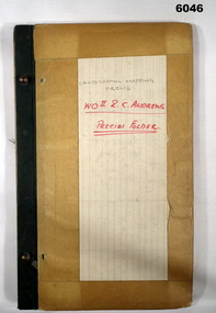
Journal - Cartographic Mapping Precis - WO2 R C Andrews Mapping Precis Folder, Circa 1960
... Survey Regiment Army Svy Regt ASR "WO II R. C. ANDREWS PRECIS FOLDER" Book with 2 x "chicago" screws, cardboard cover- brown, green cloth tape along binding edge Cartographic Mapping Precis - WO2 R C Andrews Mapping Precis Folder Journal Cartographic Mapping Precis - WO2 R C Andrews Mapping Precis Folder ...This is a compilation of Precis about cartographic mapping procedures to produce a map, compiled by WOII RC Andrews, Technical Warrant Officer Cartographic Squadron, retired 1975.Book with 2 x "chicago" screws, cardboard cover- brown, green cloth tape along binding edge"WO II R. C. ANDREWS PRECIS FOLDER"royal australian survey corps, rasvy, fortuna, army survey regiment, army svy regt, asr -
 Bendigo Military Museum
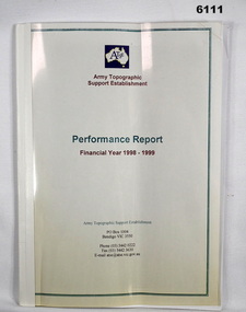
Administrative record - Army Topographic Support Establishment: Performance Report Financial Year 1998 - 1999, 13 Jul 1999
... Bendigo Military Museum 37 - 39 Pall Mall Bendigo goldfields A Report showing numerous charts of production objectives for all types of mapping production conducted by the Army Topographic Support Establishment in the Financial year 1998 - 1999 Royal Australian Survey Corps RASvy Fortuna Army Survey Regiment Army Svy Regt ASR A4 size, clear plastic front cover, white plastic back cover, bound with tape. 16 loose pages, 8 x coloured pages showing production rates, 7 x pages roduction summary and RAAF C-130E Hercules replacement programme, 1 x page summarising production. ...A Report showing numerous charts of production objectives for all types of mapping production conducted by the Army Topographic Support Establishment in the Financial year 1998 - 1999A4 size, clear plastic front cover, white plastic back cover, bound with tape. 16 loose pages, 8 x coloured pages showing production rates, 7 x pages roduction summary and RAAF C-130E Hercules replacement programme, 1 x page summarising production.royal australian survey corps, rasvy, fortuna, army survey regiment, army svy regt, asr -
 Federation University Historical Collection
Booklet - Booklet - Media Clippings, University of Ballarat: Community Service Activities, 1994
... Students from other universities to attend; Prince Edward's visit - challenge of "Great Rubber Tube Raft Regatta" at Lake Wendouree; Uni, company in joint training initiative - installation on Novell's networking software in the degree course; Uni begins study into tree threat; Eureka leadership conference in Ballarat; Leadership conference an outstanding success. computer and it newspaper items health local community involvement david james vice chancellor state's planning system martin hughes geology department neil phillips queensland university geological society of america seattle aquatic centre sue hadden research grant $75000 native grasses sculpture exhibitiontom o'donnell indian experts nursing survey rabbit survey ted lovett footballer racism in sport australian beer awards unhealthy fitness heart foundation athletics facility fitness for the elderly human movement and sports science intitute of chartered accountants networking system in degree course eureka leadership conference Symbol of University of Ballarat - cover. Buff coloured cover, black print. Pages glued and bound - black tape ...Booklet of article that appeared in the newspaper outlining events, programmes, etc. that are of community involvement. Computer and IT programmes; Uni helps kids learn about safe, active, healthy life; Uni eager to foster partnership with local community; Professor David James (Vice Chancellor) to be chair of regional consultation group reforming State's planning system; Ballarat's Martin Hughes of BU Geology Department and Queensland's Neil Phillips to present paper at Geological Society of America in Seattle; Uni to build aquatic centre to attract top swimmers; Open Days planned by Ballarat Universities; Sue Hadden, Ballarat Uni, received $75,000 grant to carry out research on Victoria's disappearing native grasses; Ballarat Uni to host major student sculpture show; Moves to develop high-tech park plan; New Research Plans assisted by Professor Tom O'Donnell; Indian experts look for answers to get more from their depleted desert forests; Uni conducts nursing survey re courses to be offered; Rabbit numbers rise - survey from farmers; Ted Lovett, VFL footballer (Fitzroy) talk on racism in sport at Ballarat Uni.; Australian beer awards at Ballarat Uni.; Study on Unhealthy Fitness - Heart Foundation suggests regular exercise at level suited to individual needs; Survey tracks path of yellow spotting; Tertiary push for hospital - Ararat; University considered for athletics facility; Top-level study on fitness for the elderly to be monitored by Human Movement and Sports Science students, University of Ballarat; Institute of Chartered Accountants will hold its annual accounting information day at the University of Ballarat's Foundation Hall. Students from other universities to attend; Prince Edward's visit - challenge of "Great Rubber Tube Raft Regatta" at Lake Wendouree; Uni, company in joint training initiative - installation on Novell's networking software in the degree course; Uni begins study into tree threat; Eureka leadership conference in Ballarat; Leadership conference an outstanding success.Buff coloured cover, black print. Pages glued and bound - black tape. Newspaper articles - photographs and print - on separate sheets in reverse order of appearance in paper; December to February.Symbol of University of Ballarat - cover.computer and it, newspaper items, health, local community involvement, david james, vice chancellor, state's planning system, martin hughes, geology department, neil phillips, queensland university, geological society of america, seattle, aquatic centre, sue hadden, research grant, $75000, native grasses, sculpture exhibitiontom o'donnell, indian experts, nursing survey, rabbit survey, ted lovett, footballer, racism in sport, australian beer awards, unhealthy fitness, heart foundation, athletics facility, fitness for the elderly, human movement and sports science, intitute of chartered accountants, networking system in degree course, eureka leadership conference -
 Eltham District Historical Society Inc
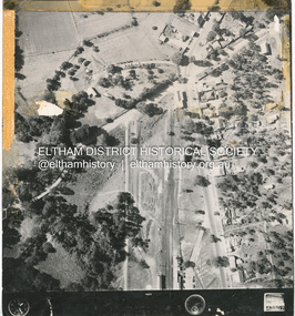
Photograph - Aerial Photograph, Main Road Hurstbridge, corner of Rose Ave, 12 Apr. 1954
... Eltham District Historical Society Inc 728 Main Rd Eltham melbourne Victorian Railways Aerial Survey shire of eltham archives Aerial Photo Main Road Anzac Avenue Hursbridge Parker Road Hurstbridge Railway Station Rose Road Black and white proto print; Size: 230x240 mm Condition: fair, sticky tape Main Road Hurstbridge, corner of Rose Ave Photograph Aerial Photograph ...Victorian Railways Aerial Surveyshire of eltham archives, aerial photo, main road, anzac avenue, hursbridge, parker road, hurstbridge railway station, rose road -
 Eltham District Historical Society Inc
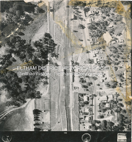
Photograph - Aerial Photograph, Main Road Hurstbridge, Rose Ave to Parker Road, 12 Apr. 1954
... Eltham District Historical Society Inc 728 Main Rd Eltham melbourne Victorian Railways Aerial Survey shire of eltham archives Aerial Photo Main Road Anzac Avenue Hursbridge Parker Road Hurstbridge Railway Station Rose Road Black and white proto print; Size: 230x240 mm Condition: fair, sticky tape Main Road Hurstbridge, Rose Ave to Parker Road Photograph Aerial Photograph ...Victorian Railways Aerial Surveyshire of eltham archives, aerial photo, main road, anzac avenue, hursbridge, parker road, hurstbridge railway station, rose road -
 Eltham District Historical Society Inc
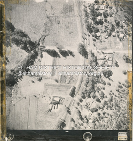
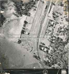
Photograph - Aerial Photograph, Main Road and Railway Station area, Hurstbridge, 12 Apr. 1954
... Eltham District Historical Society Inc 728 Main Rd Eltham melbourne Victorian Railways Aerial Survey shire of eltham archives Aerial Photo Main Road Anzac Avenue Hursbridge Parker Road Hurstbridge Railway Station Rose Road Black and white proto print; Size: 230x240 mm Condition: fair, sticky tape Main Road and Railway Station area, Hurstbridge Photograph Aerial Photograph ...Victorian Railways Aerial Surveyshire of eltham archives, aerial photo, main road, anzac avenue, hursbridge, parker road, hurstbridge railway station, rose road -
 Eltham District Historical Society Inc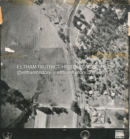
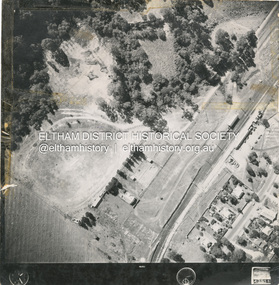
Photograph - Aerial Photograph, Main Road and Anzac Ave intersection, Hurstbridge, 12 Apr. 1954
... Eltham District Historical Society Inc 728 Main Rd Eltham melbourne Victorian Railways Aerial Survey shire of eltham archives Aerial Photo Main Road Anzac Avenue Hursbridge Parker Road Hurstbridge Railway Station Rose Road Stamped VR Aerial Survey This print is not rectified Scale Approx 160' to 1 inch Date Photographed 12.4.54 Written Series 33, Item 9 Black and white proto print; Size: 230x240 mm Condition: fair, sticky tape Main Road and Anzac Ave intersection, Hurstbridge Photograph Aerial Photograph ...Victorian Railways Aerial SurveyStamped VR Aerial Survey This print is not rectified Scale Approx 160' to 1 inch Date Photographed 12.4.54 Written Series 33, Item 9shire of eltham archives, aerial photo, main road, anzac avenue, hursbridge, parker road, hurstbridge railway station, rose road -
 Bendigo Historical Society Inc.
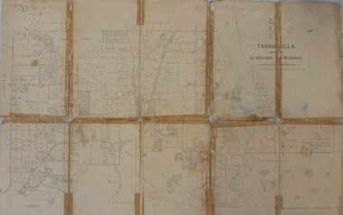
Map - JACK FLYNN MAP COLLECTION: GLADSTONE AND BENDIGO - TARNAGULLA, 13th May 1922
... Survey, Melbourne by W.J. Butson. 13.5.22 Map 388. Counties of Gladstone and Bendigo a Map of Tarnagulla with Kingower, Glenalbyn, Inglewood, Waanyarra and Laanecoorie boarding. The map is in poor condition and in several pieces. It has been previously taped ...Map 388. Counties of Gladstone and Bendigo a Map of Tarnagulla with Kingower, Glenalbyn, Inglewood, Waanyarra and Laanecoorie boarding. The map is in poor condition and in several pieces. It has been previously taped together. The front page is of red card with white tape along the spine to hold it together, top half Tarnagulla is hand written in black lead on a label with blue trim.By Authority A.J. Mullett, Government Printer, Melbourne. Photo-Lithographed at the Department of Lands and Survey, Melbourne by W.J. Butson. 13.5.22map, bendigo, tarnagulla, tarnagulla, kingower, glenalbyn, laanecoorie, inglewood. -
 Greensborough Historical Society
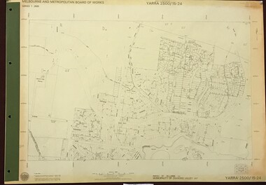
Map, Melbourne and Metropolitan Board of Works. Survey Division, MMBW, Yarra 2500 / 15.24. Diamond Creek, Grassy Flat Road, 1978_02
... tape reinforcing on edges and punched holes on left edge. MMBW, Yarra 2500 / 15.24. Diamond Creek, Grassy Flat Road. Map Map Melbourne and Metropolitan Board of Works. Survey ...Melbourne and Metropolitan Board of Works. Yarra 2500 [base map] 15.24. Diamond Creek, Grassy Flat Road. Parish of Nillumbik 3310. Municipality of Diamond Valley 257. Prominent streets include: Everleigh Drive, Broad Gully Road and Clyde Street. Features include the Diamond Creek, Nillumbik Park and Diamond Creek Reservoir.MMBW Map in 1:2500 [scale] series. Cream parchment with green tape reinforcing on edges and punched holes on left edge.mmbw, melbourne and metropolitan board of works, diamond creek - maps, shire of diamond valley -
 Orbost & District Historical Society
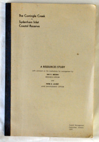
Book - front cover, The Corringle Creek to Sydenham Inlet Coastal Reserve A RESOURCES STUDY, 1977
... Survey, Victoria 1977. Printed by James Yeates Printing, Bairnsdale 3875. A buff coloured cover with black printing and blue tape binding. 71 pages + maps/charts. ...This 1977 Resources Study was a joint project of the Shire of Orbost & the Dept. of Crown Lands & Survey with the purpose of collating information on natural resources, pattern of public use, and constraints on future use so that management can be formulated.This report gives and understanding of the resources and management directions of coastal land in East Gippsland in 1977. A buff coloured cover with black printing and blue tape binding. 71 pages + maps/charts. THE CORRINGLE CREEK TO SYDENHAM INLET COASTAL RESERVE. A resources study with comment on the implications for management by IAN R. BROWN Research officer and PETER B. LAVERY Land Management Oficer. Coastal management Committee Victoria 1977. Published under the authority of the Coastal Management Committee by the Department of Crown Lands and Survey, Victoria 1977. Printed by James Yeates Printing, Bairnsdale 3875.corringle creek, sydenham inlet, natural resources survey -
Federation University Historical Collection
Map - Map - Geological, Geological Survey of Victoria - Ballarat, 09/1858
... tape. The map show alluvial silt, gold drift, geological orders, volcanic, and gold workings. Scale is 8 chains to an inch. WGS 84 Centroid: 37 degrees 33 feet 33 inches south 143 degrees 52 feet 02 inches east W.E. extent: 5km NS extent: 3 km Geological Survey of Victoria - Ballarat Map Map - Geological J. ...Coloured Geological Map of Ballarat, edged with masking tape. The map show alluvial silt, gold drift, geological orders, volcanic, and gold workings. Scale is 8 chains to an inch. WGS 84 Centroid: 37 degrees 33 feet 33 inches south 143 degrees 52 feet 02 inches east W.E. extent: 5km NS extent: 3 kmballarat, ballaarat, geology, goldfield, phillips, j. phillips, mining, alfred selwyn, ferguson and mitchell -
 Federation University Historical Collection
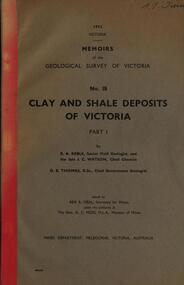
Book, Memoirs of the Geological Survey of Victoria; No 18, Clay and Shale Deposits of Victoria, 1952
... tape spine. The 76 pages clay deposits, composition of Victorian clays, clay localities, granitic clays, Residual Clays, Clay-Shales, Jurassic clay shales. Memoirs of the Geological Survey ...Grey soft covered book with red tape spine. The 76 pages clay deposits, composition of Victorian clays, clay localities, granitic clays, Residual Clays, Clay-Shales, Jurassic clay shales.r a keble, senior field geologist, j c watson, chief chemist, d e watson, chief government geologist, g c moss, minister of mines, mallee plains, avoca valley, loddon valley, campaspe valley, goulburn valley, kiewa, mitta, glenelg valley, pitfield valley, otway area, moorabool valley, darley fireclay, campbellfield clay, latrobe river valley, hendley, ball clays, felspars, pegmatities, quartz, pakenham fireclay, bulla china clay, kaolin, terracotta, stoneware, ballan dyke-belt, egerton, gordon, ballan, llandeilo, colbrook, elaine, lal lal, maryborough, ballarat, ringwood, siliceous clay, stawell, dromana, ptways, bulla, pyalong china clay, linton china clay, wedderburn clays, lal lal china clays, ballan dyke belt, reginald callister, knight's koalin pottery, china clay, ferdinand krause, clarendon, bittern, frichot, hunt's dam, vaughan, rosenow, hickey, malone, claypits, ballarat dyke belt, stawell dyke belt, maryborough dyke belt, guildford, daylesford, ovens valley -
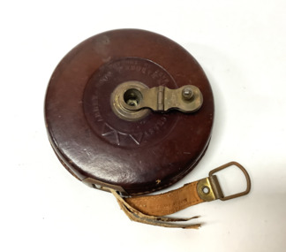 Williamstown Historical Society Inc
Tool - Surveyors tape measure
... surveying, especially for measuring land was often done in links. One link equated to 7.92 inches long, which is 20.12 centimeters, or one percent of a chain, which is 66 feet, or 2,011 centimetres long. On the tape ...Early surveying, especially for measuring land was often done in links. One link equated to 7.92 inches long, which is 20.12 centimeters, or one percent of a chain, which is 66 feet, or 2,011 centimetres long.A vintage Rabone tape measure in a brown leather case with a brass winding handle.The tape has a length of 66 feet, the length of a chain. One side of the tape is marked in inches and the reverse side is marked in linksOn the tape: "John Rabone & Co Hockley Made in England" -
Tatura Irrigation & Wartime Camps Museum
Audio Tape, Walking tour of Camp 1 with Jenny Dumble who conducted an archaelogical survey thereof, 1990
... Jenny Dumble archaeological survey Camp remains Camp 1 Jenny Dumble audio tape 90 minutes Walking tour of Camp 1 with Jenny Dumble who conducted an archaelogical survey thereof., Audio Tape. ...Walking tour of camp 1 with Jenny Dumble who had just completed an archaeological survey of the camp remains. Members of T & D Historical Society accompanied.audio tape 90 minutesCamp 1 Jenny Dumblejenny dumble, archaeological survey, camp remains -
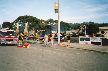 Lakes Entrance Historical Society
Photograph - Club Hotel Fire Lakes Entrance Victoria, LERHS, 2000
... Fire truck and brigade members in taped off area damping down debris. Onlookers survey damage of early morning fire. ...Fire truck and brigade members in taped off area damping down debris. Onlookers survey damage of early morning fire. ...Date made December 2000Colour photograph showing the Club Hotel, after the fire had destroyed the buildings. Signage for the bistro and holiday tourism flag on the electricity pole. Fire truck and brigade members in taped off area damping down debris. Onlookers survey damage of early morning fire. Lakes Entrance Victoriahotels, fire brigade, disasters