Showing 125 items matching "technology -- australia -- history."
-
 Kew Historical Society Inc
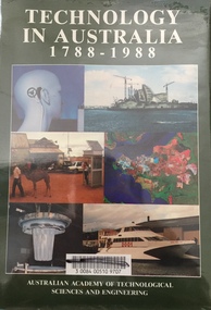
Book - Brown Gouge clothes brush, Australian Academy of Technological Sciences and Engineering, Technology in Australia, 1788-1988 : A condensed history of Australian technological innovation and adaptation during the first two hundred years, 1988
... Technology in Australia, 1788-1988 : A condensed history of Australian technological innovation and adaptation during the first two hundred years...technology -- australia -- history....technology. Water and irrigation. Forestry and forest products. Australian innovation in textile technology. Engineering, construction and building. Transport. Communications and computers. The chemical industry and Australian contributions to chemical technology. The mineral industries. Energy. Manufacturing industry. Defence science and technology. I technology -- australia -- history ...This book provides a history of technology in Australia from 1788 to 1988. There are twelve chapters by different authors. These chapters are: Innovation, science and the farmer (D.E. Tribe and L.J. Peel) Food technology (K.T.H. Farrer) Water and irrigation (K.D. Green) Forestry and forest products (W.H. Algar) Australian innovation in textile technology (D.S. Taylor) Engineering construction and building (J. Holland) Transport (B. Inglis) Communications and computers (J.H. Curtis and T. Pearcey) The chemical industry and Australian contributions to chemical technology (J.E. Kolm) The mineral industries (G.B. O'Malley) Energy (R.N. Morse) Manufacturing industry (P.N. Richards) Defence science and technology (J.L. Farrands and J.C. Wisdom) Index, photographs.Melbourne : Australian Academy of Technological Sciences and Engineering, c1988 xxix, 1017 p. : ill., maps, ports., plans, facsims. ; 26 cm. non-fictionThis book provides a history of technology in Australia from 1788 to 1988. There are twelve chapters by different authors. These chapters are: Innovation, science and the farmer (D.E. Tribe and L.J. Peel) Food technology (K.T.H. Farrer) Water and irrigation (K.D. Green) Forestry and forest products (W.H. Algar) Australian innovation in textile technology (D.S. Taylor) Engineering construction and building (J. Holland) Transport (B. Inglis) Communications and computers (J.H. Curtis and T. Pearcey) The chemical industry and Australian contributions to chemical technology (J.E. Kolm) The mineral industries (G.B. O'Malley) Energy (R.N. Morse) Manufacturing industry (P.N. Richards) Defence science and technology (J.L. Farrands and J.C. Wisdom) Index, photographs.technology -- australia -- history., technological innovations -- australia -- history. -
 Warrnambool and District Historical Society Inc.
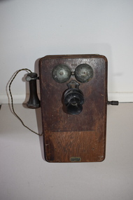
Wall Telephone, Early 20th century
... Australian P.M.G. when there was a shortage of telephones in the 1930s Depression and during World War Two. This item, a reminder of the days of early technology, has no known local provenance but is retained for display and research purposes. Vintage wall telephones history ...Magneto wall telephones such as this one were commonly in use in Australia around the end of the 19th century and the beginning of the 20th century. The wall telephone, powered by dry cells, was an invention of the late 1870s. In the first half of the 20th century many old wall telephones were restored and put back in use by the Australian P.M.G. when there was a shortage of telephones in the 1930s Depression and during World War Two. This item, a reminder of the days of early technology, has no known local provenance but is retained for display and research purposes.This telephone piece is contained within a brown wooden box with a back board that has curved edges and extends over the edges of the box. On the back there are three metal screws for attaching the box to a wall or door. The front section of the box has curved edges with an inset panel around the edges. There is a metal turning handle on one side of the box and on the other side there is a metal clip holding a hearing piece attached to the box by a cord. On the front of the box is a speaking piece attached to the box by a metal piece. Attached to the front of the box are two semi-circular ringing pieces now situated some centimetres out from the box. The box was originally varnished but the edges are now rubbed and there are some splotches of paint. vintage wall telephones, history of warrnambool, magneto wall telephones -
 Bendigo Military Museum
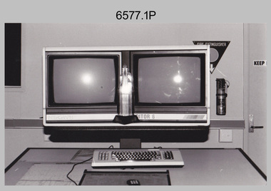
Photograph - AITA Award - RA Svy’s AUTOMAP 2 Computer Based Map Production System, Army Survey Regiment, Fortuna, Bendigo, 1984
... history and photographs of the AUTOMAP 2 system. Royal Australian Survey Corps RASvy Army Survey Regiment Army Svy Regt Fortuna .1P to .3P –No personnel are identified. ‘AITI Award to AUTOMAP II 1984’ annotated on cover sleeve. This collection of three photos of the Australian information Technology ...This collection of three photos of the Australian information Technology Award (AITA) won by the Royal Australian Survey Corps (RA Svy) AUTOMAP 2 computer-based map production system, was taken in 1984 at the Army Survey Regiment, Fortuna, Bendigo. The following article appeared in the ARMY Newspaper on Thursday 21st February 1985. ‘In computerised map production. Survey soldiers lead the world. BENDIGO: Army surveyors have been put on the map as world leaders in computerised map production following the Australian information Technology Awards. RA Svy won the Computer Assisted Draughting – Mapping section for its Automap II System which has created considerable interest among overseas defence experts. The award for the digital mapping system was accepted by OC Air Survey Sqn, MAJ Rob John, who said it was a great morale-booster for the soldiers of the Bonegilla (sic)* -based Army Survey Regiment. "Setting up a state-of-the-art system like Automap II. is an enormous task, " he said. "We started in August 1983 and it's only recently that we have achieved production results. "We were all very pleased to have our efforts recognised in this way. “Of course, credit must also go to the Intergraph Corporation for manufacturing the system and carrying out most of the development." RA Svy is responsible for producing all of Australia's maps used for defence purposes. Its topographical maps have a scale of 1:50,000 or 1:100,000 although Automap II has the capability of producing smaller scale maps - down to 1: 2,000,000. Automap II consists of three computers and three sub-systems: input, raster scanning, and graphic edit. The input sub-system has eight stereo plotters, two interactive graphic workstations and a system manager workstation. The stereo plotters use superimposition optics to digitise features from aerial photographs. It incorporates a voice recognition system so the operator can simply say "House", "Windmill", etc; and the relevant feature will be incorporated in the digital picture. Individual map separations are scanned and converted by the raster scanning sub-system to a digital raster image. This image is then converted to a graphics file in Intergraph format.’ *Note – the Army Survey Regiment was located in Bendigo, not Bonegilla as incorrectly stated in the article. The article appears on Page 137 of Valerie Lovejoy’s book 'Mapmakers of Fortuna – A history of the Army Survey Regiment’ ISBN: 0-646-42120-4. Additional history of the AUTOMAP 2 system with historic photographs is covered in pages 119, 137-143 and 157 of the 'Mapmakers of Fortuna’ book. See item 6223.23P for additional history and photographs of the AUTOMAP 2 system.This collection of three photos of the Australian information Technology Award (AITA) won by the Royal Australian Survey Corps (RA Svy)’s AUTOMAP 2 computer-based map production system, was taken in 1984 at the Army Survey Regiment, Fortuna, Bendigo. The photographs are printed on photographic paper and are part of the Army Survey Regiment’s Collection. The black and white photographs were scanned at 300 dpi. .1) - Photo, black & white, 1984, AITA Award sitting between the dual screens of an AUTOMAP 2 Graphic Edit Workstation. .2) - Photo, black & white, 1984, MAJ Job Johns (centre) and two of Intergraph Corporation IT engineers proudly hold the AITA Award next to an AUTOMAP 2 Graphic Edit Workstation. .3) - Photo, black & white, 1984, The AITA Award displayed on a pedestal in the Army Survey Regiment Officers Mess. .1P to .3P –No personnel are identified. ‘AITI Award to AUTOMAP II 1984’ annotated on cover sleeve. royal australian survey corps, rasvy, army survey regiment, army svy regt, fortuna -
 Bendigo Military Museum
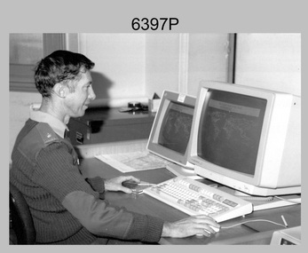
Photograph - MAJ Bob Williams – Technical Award Recipient, Army Survey Regiment, Fortuna, Bendigo, 1990
... Australia Post. These achievements are covered in more detail in page 147 of Valerie Lovejoy’s book 'Mapmakers of Fortuna – A history of the Army Survey Regiment’ ISBN: 0-646-42120-4. Royal Australian Survey Corps RASvy Army Survey Regiment Army Svy Regt Fortuna ASR .1P – annotated in red pen ‘MAJ Williams Technology Awards’ This photograph of MAJ Bob Williams was taken in Technical Development Cell at the Army Survey Regiment, Fortuna, Bendigo in 1990. ...In 1990 MAJ Bob Williams was the OC of Technical Development Cell. He won first prize for his entry ‘Innovations in Cartographic Communication’ in the individual category at the 2nd Australian Institute of Cartographers and BHP Engineering Technology Research and Development Awards. The award was announced at the 1990 Australian Cartographic Conference in Darwin where MAJ Williams presented his entry. At the time he had completed PhD studies at the Australian Defence Academy and was the first Survey Corps officer to complete studies at this advanced level. Also, in 1990 the Royal Australian Survey Corps’ meritorious achievements were formally recognised by the Senate of the Australian Parliament in a Notice of Motion on 31st of May 1990. The Royal Australian Survey Corps also featured in the issue of a commemorative stamped envelope issued by Australia Post. These achievements are covered in more detail in page 147 of Valerie Lovejoy’s book 'Mapmakers of Fortuna – A history of the Army Survey Regiment’ ISBN: 0-646-42120-4. This photograph of MAJ Bob Williams was taken in Technical Development Cell at the Army Survey Regiment, Fortuna, Bendigo in 1990. The black & white photograph was printed on photographic paper and is part of the Army Survey Regiment’s Collection. The photograph was scanned at 300 dpi. .1) - Photo, black & white, 1990. MAJ Bob Williams – Technology Award Recipient.1P – annotated in red pen ‘MAJ Williams Technology Awards’royal australian survey corps, rasvy, army survey regiment, army svy regt, fortuna, asr -
 Bendigo Military Museum
Print - PRINT, FRAMED
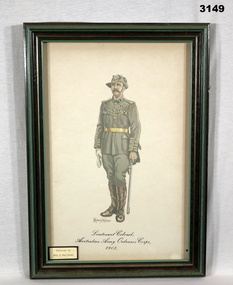
... Bendigo Military Museum 37 - 39 Pall Mall Bendigo goldfields illustrations-prints frame accessories glass technology military history - army Ordnance Underneath print: “Monty Wedd” On base of print: “Lieutenant Colonel Australian Army Ordnance Corps 1903” Green, wooden frame, glass front. ...Green, wooden frame, glass front. Enclosed is a coloured print of a painting of Lt Col Australian Army Ordnance Corp 1903.Underneath print: “Monty Wedd” On base of print: “Lieutenant Colonel Australian Army Ordnance Corps 1903”illustrations-prints, frame accessories, glass technology, military history - army, ordnance -
 Bendigo Military Museum
Memorabilia - MEDALLION, GALLIPOLI, Military Shop, post 2000
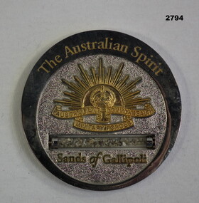
... Bendigo Military Museum 37 - 39 Pall Mall Bendigo goldfields military history - souvenirs glass technology metalcraft - silverware Passchendaele barracks trust Wording on rear: "Beneath the Sea in the Sands of Gallipoli A Soldier's Badge. Ordinary People Extraordinary Service" Medallion, round, silver. Words at top: The Australian ...Medallion, round, silver. Words at top: The Australian Spirit. Gold Rising Sun in centre. Small glass cylinder of sand. Words in gold at bottom: Sands of Gallipoli.Wording on rear: "Beneath the Sea in the Sands of Gallipoli A Soldier's Badge. Ordinary People Extraordinary Service"military history - souvenirs, glass technology, metalcraft - silverware, passchendaele barracks trust -
 Bendigo Military Museum
Memorabilia - PASSENGER LIST WW2, Oct-Nov 1940
... Refer Cat No 2039 for his service history. documents - lists maritime technology Cunard Mary Signed on front "B.R. CHADD" CUNARD WHITE STAR (Shipping Line) H.T Queen Mary Australian Imperial Forces Memorabilia PASSENGER LIST WW2 ...Item belonged to Benjamin Thomas Roy Chadd No's 10594, VX20311, 1st and 2nd AIF. Refer Cat No 2039 for his service history.CUNARD WHITE STAR (Shipping Line) H.T Queen Mary Australian Imperial ForcesSigned on front "B.R. CHADD"documents - lists, maritime technology, cunard, mary -
 Federation University Historical Collection
Document - Document - Presentation, VIOSH: Social History; Introduction to Sociology of Work and Technology Presentation, post 1997
... Following the introductory speech, the talk gave information on the development, problems and theory of designing safe workplaces. viosh victorian institute of occupational safety and health social history sociology derek viner course co-ordinator tom norwood head of mechanical engineering eric wigglesworth chairman education committee of the safety institute of australia zig plavina technical officer school of engineering campus safety committee university of aston dennis else One A4 page typed. VIOSH: Social History; Introduction to Sociology of Work and Technology ...Victorian Institute of Occupational Safety and Health (VIOSH) Australia is the Asia-Pacific centre for teaching and research in occupational health and safety (OHS) and is known as one of Australia's leaders on the field. VIOSH has a global reputation for its innovative approach within the field of OHS management. VIOSH had its first intake of students in 1979. At that time the Institution was known as the Ballarat College of Advanced Education. In 1990 it became known as Ballarat University College, then in 1994 as University of Ballarat. It was 2014 that it became Federation University. VIOSH Australia students are safety managers, senior advisors and experienced OHS professionals. They come from all over Australia and industry. Students are taught active research and enquiry; rather than textbook learning and a one-size fits all approach. VIOSH accepts people into the Graduate Diploma of Occupational Hazard Management who have no undergraduate degree - on the basis of extensive work experience and knowledge. Brief outline of the history of the development of VIOSH, and those responsible. They were Derek Viner (the initial Course Co-ordinator), Mr Tom Norwood (Head of the Mechanical Engineering Department), Mr Eric Wigglesworth (Chairman of the Education Committee of the Safety Institute of Australia) and Mr Zig Plavina (Technical Officer in the School of Engineering and Secretary of the Campus Safety Committee). Dr Dennis Else from the University of Aston, Birmingham arrived to establish the Victorian Institute of Occupational Safety and Health within the Engineering division of the University. Following the introductory speech, the talk gave information on the development, problems and theory of designing safe workplaces.One A4 page typed.viosh, victorian institute of occupational safety and health, social history, sociology, derek viner, course co-ordinator, tom norwood, head of mechanical engineering, eric wigglesworth, chairman, education committee of the safety institute of australia, zig plavina, technical officer, school of engineering, campus safety committee, university of aston, dennis else -
 Orbost & District Historical Society
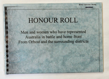
book, Honour Roll, 1998
... Orbost & District Historical Society Ruskin Street Orbost gippsland This was published by Years 9/10 Information Technology Class at Orbost Secondary College with information provided by Mrs Lottie Johnston. military Orbost-history honour-roll A copy of a small publication of 86pp. It has a plastic cover and is titled Honour Roll. It contains the names of those from Orbost and surrounding districts who have represented Australia ...This was published by Years 9/10 Information Technology Class at Orbost Secondary College with information provided by Mrs Lottie Johnston.A copy of a small publication of 86pp. It has a plastic cover and is titled Honour Roll. It contains the names of those from Orbost and surrounding districts who have represented Australia in battle overseas and on the homefront.military orbost-history honour-roll -
 Federation University Historical Collection
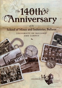
Booklet, The 140th Anniversary of the School of Mines and Industries, Ballarat: University of Ballarat SMB Campus, 2010, 2010
... Barker Library (top floor) Mount Helen goldfields ballarat school of mines anniversary 140th anniversary smb campus david battersby timeline trades manufactuyring services cindy brundell graeme hood electrical engineering celtlink geoff mainwaring julia mainwaring australian war artist prospects training restaurant li ji yuane caitlyn murrell joshua martin ballarat gaol ballarat gaol cells eerie tours ghost tours nathanie buchanan peter dyer ben swanson nikki green dylan reece matthew lewis business services betty collier feduni college ub tec manutacturing technology training centre mttc brewery complex Twenty two page Ballarat Courier supplement celebrating the 140th year since the establishment of the Ballarat School of Mines. Contents include a timeline; Ballarat School of Mines HIstory ...Twenty two page Ballarat Courier supplement celebrating the 140th year since the establishment of the Ballarat School of Mines. Contents include a timeline; Ballarat School of Mines HIstory; Graeme Hood and Electrical Engineering; Australian War Artist Geoff Mainwaring, Prospects Training Restaurant; Ballarat Gaol, Gaol cells underneath the E.J. Tippett Library; Ghost tours; School of Business; Brewery Complex.ballarat school of mines, anniversary, 140th anniversary, smb campus, david battersby, timeline, trades, manufactuyring services, cindy brundell, graeme hood, electrical engineering, celtlink, geoff mainwaring, julia mainwaring, australian war artist, prospects training restaurant, li ji yuane, caitlyn murrell, joshua martin, ballarat gaol, ballarat gaol cells, eerie tours, ghost tours, nathanie buchanan, peter dyer, ben swanson, nikki green, dylan reece, matthew lewis, business services, betty collier, feduni college, ub tec, manutacturing technology training centre, mttc, brewery complex -
 Federation University Historical Collection
Folders, University of Ballarat Procedures, Policies and Regulations Manual, 1996, 1996
... Australia E.J. Barker Library (top floor) Mount Helen goldfields university of ballarat policy university of ballarat regulations university o fballarat procedures rules equal opportunity policy areboretum health and safety equity policy affirmitive action plan sex neutral language guidelines ballarat technology park food crop development centre aquatics laboratory university establishment origins of the univeristy history ballarat isntitute of advanced education state college of victoria at ballarat merger ballarat college of advanced education tertiary education act campus development 1967-1993 naming of major buildings e.j. barker library ian gordon (education) building university land evolution of the university of ballarat academic board university of ballarat student association ltf m.b. ...Two white ring folders containing University of Ballarat containing Procedures, Policies and Regulationsuniversity of ballarat policy, university of ballarat regulations, university o fballarat procedures, rules, equal opportunity policy, areboretum, health and safety, equity policy, affirmitive action plan, sex neutral language guidelines, ballarat technology park, food crop development centre, aquatics laboratory, university establishment, origins of the univeristy, history, ballarat isntitute of advanced education, state college of victoria at ballarat, merger, ballarat college of advanced education, tertiary education act, campus development 1967-1993, naming of major buildings, e.j. barker library, ian gordon (education) building, university land, evolution of the university of ballarat, academic board, university of ballarat student association ltf, m.b. john building -
Federation University Historical Collection
Book - Book - Scrapbook, Ballarat School of MInes: Scrapbook of Newspaper Cuttings, Book 67, December 1994 to March 1995
... The papers concerned are The Courier, Ballarat, The Australian, The Age over the period of 24 December 1994 to 9 March 1995. teaching positions advertised pre-employment courses courses available enrolment for smb courses smb help farmers tafe meets student needs historically a great city geoffrey blainey carole seymour victorian public service medal kevin martin ararat sm clinton miller draughtsman international skills olympics france mature age students ararat $12m information technology centre at ballarat university $6m for smb brewery site english course for overseas students university placements kennett funding for country tafe basic engineering courses at tafe libraries to combine resources bill hitchens ballarat university australian catholic university veronica moriarty barry firth smb training that suits veryone youth theatre workshops building links with industry family history component ballarat region's workskill peter morey sharon graham Book with yellow cover, front, spiral bound. ...Collection of newspaper articles related to Ballarat School Of Mines.They cover activities and advertisements for staff. The papers concerned are The Courier, Ballarat, The Australian, The Age over the period of 24 December 1994 to 9 March 1995.Book with yellow cover, front, spiral bound. teaching positions advertised, pre-employment courses, courses available, enrolment for smb courses, smb help farmers, tafe meets student needs, historically a great city, geoffrey blainey, carole seymour, victorian public service medal, kevin martin ararat sm, clinton miller draughtsman, international skills olympics france, mature age students ararat, $12m information technology centre at ballarat university, $6m for smb brewery site, english course for overseas students, university placements, kennett funding for country tafe, basic engineering courses at tafe, libraries to combine resources, bill hitchens, ballarat university, australian catholic university, veronica moriarty, barry firth, smb, training that suits veryone, youth theatre workshops, building links with industry, family history component, ballarat region's workskill, peter morey, sharon graham -
Federation University Historical Collection
Book - Book - Scrapbook, Ballarat Institute of Advanced Education: Scrapbook of newspaper cutting, Book 5, August 1971 to December 1971
... Australian, The Herald. The cuttings cover the period from 19 August 1971 to 1 December 1971. ballarat institute of advanced education biae employment advertisements application for enrolment outline of courses smb finances concern mildura visitors testing new wind tunnel derek vine zig placina excellent year for association jack barker biae art show woman on a bike letters to the editor re art show 1500 trees planted biae students call strike new courses approved new physics equipment apartheid history explained derek viner talk student protest backed ballarat trades and labor council support prahran college of technology seeks supporters role of colleges threatened teacher training new regional office - education dept clay pit plans equipment for biae art display by smb students teachers to conduct assessment experiment undermining our sold foundation pioneer experiment at biae national diploma controls needed f r hornby colleges and students - 1972 helping hand for overseas students gordon smith teachers' colleges accommodation at technical schools victorian teachers' union concerns exceptions in an imperfect world student housing local degree courses on secondary studentships problem for school leavers $250000 for biae union building death of harry arblaster - former smb principal model of building project engineers' seminar at ballarat Book with orange cover, front. ...Newspaper cuttings relating to Ballarat Institute of Advanced Education. These are from various newspapers and include The Age, Ballarat Courier, The Australian, The Herald. The cuttings cover the period from 19 August 1971 to 1 December 1971. Book with orange cover, front. Spiral bound. Large tear back cover.ballarat institute of advanced education, biae, employment advertisements, application for enrolment, outline of courses, smb finances concern, mildura visitors, testing new wind tunnel, derek vine, zig placina, excellent year for association, jack barker, biae art show, woman on a bike, letters to the editor re art show, 1500 trees planted, biae students call strike, new courses approved, new physics equipment, apartheid history explained, derek viner talk, student protest backed, ballarat trades and labor council support, prahran college of technology seeks supporters, role of colleges threatened, teacher training, new regional office - education dept, clay pit plans, equipment for biae, art display by smb students, teachers to conduct assessment experiment, undermining our sold foundation, pioneer experiment at biae, national diploma controls needed, f r hornby, colleges and students - 1972, helping hand for overseas students, gordon smith, teachers' colleges, accommodation at technical schools, victorian teachers' union concerns, exceptions in an imperfect world, student housing, local degree courses on secondary studentships, problem for school leavers, $250000 for biae union building, death of harry arblaster - former smb principal, model of building project, engineers' seminar at ballarat -
 Glen Eira Historical Society
Article - Caulfield Institute of Technology
... Four items about the establishment,history and courses provided at this Institute: 1/Research notes (2 pages in all) regarding the renaming of Caulfield Technical School to Caulfield Institute of Technology in 1968 sourced from La Trobe Library Reference Index. Several dates listed. Reference also to article on construction of building in 'Australian...Glen Eira Historical Society 965 Glen Huntly Rd Caulfield VIC 3162 melbourne Four items about the establishment,history and courses provided at this Institute: 1/Research notes (2 pages in all) regarding the renaming of Caulfield Technical School to Caulfield Institute of Technology in 1968 sourced from La Trobe Library Reference Index. Several dates listed. Reference also to article on construction of building in 'Australian ...Four items about the establishment,history and courses provided at this Institute: 1/Research notes (2 pages in all) regarding the renaming of Caulfield Technical School to Caulfield Institute of Technology in 1968 sourced from La Trobe Library Reference Index. Several dates listed. Reference also to article on construction of building in 'Australian Builder' of January 1950. 2/Photocopy of article from 'The Australian Accountant', April 1975. Gives history of C.I.T. and of Business School courses plus photos. (3 pages) 3/Advertising flyer for 'The David Syme Business School at CIT' listing courses for enrolment by 15/12/1978. 4/Undated black and white photograph of building in progress on site of Caulfield Institute/Monash University Caulfield. Noted on reverse'Chisholm Tower', 'Contact June 29, PIC 3 PG3 100% pl2' ie likely taken by photographer for 'Caulfield Contact'.miller j.o. mr. (b.a. b. com. f.a.s.a.), huggan noel, halstead h.j. mr., kurtz david professor, holmes graham, collins mike, chataway graham, erdonmez hassan, gleeson june, voumard lou, coombe jack, caulfield technical college, caulfield technical school, caulfield institute of technology (cit), k.h. boykett building, monash university, dandenong road, caulfield east, victorian education department, school of business, school of applied sciences, school of engineering, school of industrial studies, school of general studies (humanities sociology art and design), technical schools, technical colleges, education, secondary education, mature age students, david syme business school, 'contact' -
 Bendigo Historical Society Inc.
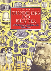
Book - CHANDELIERS AND BILLY TEA - A CATALOGUE OF AUSTRALIAN LIFE 1880 - 1940, 1984
... AUSTRALIA...Culture...culture... fashion... history of technology...History House 11 Mackenzie Street Bendigo goldfields AUSTRALIA Culture culture fashion history of technology Butterick fashions Peter Cuffley Chandeliers and billy tea - a catalogue of Australian life 1880 - 1940. 224 pages with photos and illustrations. ...Chandeliers and billy tea - a catalogue of Australian life 1880 - 1940. 224 pages with photos and illustrations. Published by Five Mile Press, Hawthorn, Vic.Peter Cuffleyaustralia, culture, culture, fashion, history of technology, butterick fashions -
 Bendigo Historical Society Inc.
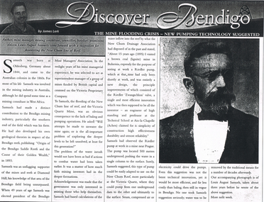
Newspaper - LONG GULLY HISTORY GROUP COLLECTION: THE MINE FLOODING CRISIS - NEW PUMPING TECHNOLOGY SUGGESTED
... History House 11 Mackenzie Street Bendigo goldfields BENDIGO History long gully history group The Long Gully History Group - The Mine Flooding Crisis - New Pumping Technology Suggested Bendigo Weekly 9/6/2000 James Lerk Louis August Samuels Origin of the Bendigo Saddle Reefs and the Cause of their Golden Wealth 1893 Bendigo Mine Managers' Association Victoria Proprietary Company Victoria Quartz Mine New Chum Drainage Association Riedler Pump Riedler Zwangschluss valve Technical School at Aix-la-Chapelle (Achen) Copy of an article from the Bendigo Weekly 9/6/2000 titled The Mine Flooding Crisis - New Pumping Technology Suggested by James Lerk. Louis August Samuels was born in Germany. Samuels was involved in the mining industry in Australia ...Copy of an article from the Bendigo Weekly 9/6/2000 titled The Mine Flooding Crisis - New Pumping Technology Suggested by James Lerk. Louis August Samuels was born in Germany. Samuels was involved in the mining industry in Australia and he had mining experience in West Africa. He had knowledge of the mines at the southern end of the field. He was president of the Mine Managers' Association. He believed the flooding was caused by the lack of baling and pumping operations. Earlier he had visited a coal mine in Bohemia to see a Riedler pump at work. It was a new design, very effective, simple in design and reliable. He watched it work. It was 500 metres underground and pushed the water to the surface in a single column. He suggested this type of pump could be adapted to use on the New Chum Reef. Even this suggestion was not the latest technical innovation, but it would be more efficient and less costly than baling. No one took him seriously and continued to remove water by the traditional means. Article is accompanied by a photo of Samuels.bendigo, history, long gully history group, the long gully history group - the mine flooding crisis - new pumping technology suggested, bendigo weekly 9/6/2000, james lerk, louis august samuels, origin of the bendigo saddle reefs and the cause of their golden wealth 1893, bendigo mine managers' association, victoria proprietary company, victoria quartz mine, new chum drainage association, riedler pump, riedler zwangschluss valve, technical school at aix-la-chapelle (achen) -
 Bendigo Historical Society Inc.
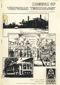
Book - MUSEUM OF VICTORIAN TECHNOLOGY - AN EMPLOYMENT INITIATIVES PROGRAMME, c1983
... History House 11 Mackenzie Street Bendigo goldfields BENDIGO History victorian technology cast iron museum gas works tourism Bendigo Bendigo City Council, Bendigo Trust and National Trust of Australia (Victoria) Museum of Victorian Technology - An Employment Initiatives Programme. ...Museum of Victorian Technology - An Employment Initiatives Programme. Project outline and detail for development of a Museum of Victorian Technology at the Old Gasworks Bendigo. Black and white Illustrations & maps.Bendigo City Council, Bendigo Trust and National Trust of Australia (Victoria)bendigo, history, victorian technology, cast iron museum gas works tourism bendigo -
 Bendigo Historical Society Inc.
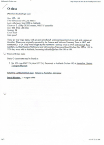
Document - LONG GULLY HISTORY GROUP COLLECTION: TRAMS INFORMATION
... History House 11 Mackenzie Street Bendigo goldfields BENDIGO History long gully history group The Long Gully History Group - Trams Information Prahan and Malvern tramway Trust Hawthorn Tramway Trust Melbourne and Metropolitan tramways Board Australian Electric Transport Museum David Hoadley Tramway Musuem of Victoria Hawthorn Tram Depot David Bromage Sydney Tramway Museum Bendigo Tramways Museum of Transport and Technology NZ Whiteman Park Tramway Museum Haddon Tramway Museum The Old Canberra Tram Company Ballarat Vintage Tramway Bendigo Toastrack Tram Kilmore Cable Tramway Railway Museum Scienceworks Tasmanian Transport Museum Launceston Tramway Museum Society Ballarat Vintage Tramway Central Deborah Gold Mine Chinese Joss House Castleton Sandhurst Shamrock Hotels Dai Gum San Wax Museum Post Office Law Courts Alexandra Fountain Beehive Store Fortuna Villa Sandhurst Town Information on O Class Trams, First introduced, Last Withdrawn, Electrics, Size and Seating, W2 with a small photo, where they can be found, some went to the USA, W5 with a small photo, W6 and the Bendigo Toastrack Tram with Nos, Introduced, Withdrawn, Electrics, Size and Seating/Crush Load. ...Information on O Class Trams, First introduced, Last Withdrawn, Electrics, Size and Seating, W2 with a small photo, where they can be found, some went to the USA, W5 with a small photo, W6 and the Bendigo Toastrack Tram with Nos, Introduced, Withdrawn, Electrics, Size and Seating/Crush Load. Also listed is where other trams can be seen. Also mentioned some early history of Bendigo, The Heritage Walk, The Central Deborah, Sandhurst Town, the early route from Melbourne to Bendigo, Creswick, Castlemaine and the Old Market. (7 pages).bendigo, history, long gully history group, the long gully history group - trams information, prahan and malvern tramway trust, hawthorn tramway trust, melbourne and metropolitan tramways board, australian electric transport museum, david hoadley, tramway musuem of victoria, hawthorn tram depot, david bromage, sydney tramway museum, bendigo tramways, museum of transport and technology nz, whiteman park tramway museum, haddon tramway museum, the old canberra tram company, ballarat vintage tramway, bendigo toastrack tram, kilmore cable tramway, railway museum, scienceworks, tasmanian transport museum, launceston tramway museum society, ballarat vintage tramway, central deborah gold mine, chinese joss house, castleton, sandhurst, shamrock hotels, dai gum san wax museum, post office, law courts, alexandra fountain, beehive store, fortuna villa, sandhurst town -
 Bendigo Historical Society Inc.
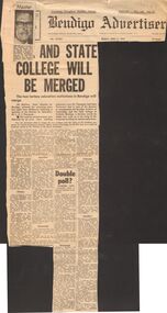
Document - LA TROBE UNIVERSITY BENDIGO COLLECTION: B.I.T. AND STATE COLLEGE WILL BE MERGED
... History House 11 Mackenzie Street Bendigo goldfields BENDIGO Education bit and btc merger La Trobe University Bendigo Collection collection Bendigo Bendige Teachers' College Bendigo Institute of Technology Mr. Ralph Winter Birrell Mr. K.G. Scarrott merger amalgamation education tertiary photo photograph A 'Bendigo Advertiser' article with the heading ' B.I.T. and State College Will Be Merged. ' Mr. McClure State Member for Bendigo released the news about the merger and the site of the building proposed for teacher education. The decision was greeted with contrasting dismay, excitement and resignation. Mr. K.G. Scarrott, the Principal of Bendigo Teachers' College said the Australian ...A 'Bendigo Advertiser' article with the heading ' B.I.T. and State College Will Be Merged. ' Mr. McClure State Member for Bendigo released the news about the merger and the site of the building proposed for teacher education. The decision was greeted with contrasting dismay, excitement and resignation. Mr. K.G. Scarrott, the Principal of Bendigo Teachers' College said the Australian Universities Commission recommended the merger in their report. Also attached to this article is a small photo of Mr. Ralph Birrell the Principal of Bendigo Institute of Technology. Friday, April 5, 1974.bendigo, education, bit and btc merger, la trobe university bendigo collection, collection, bendigo, bendige teachers' college, bendigo institute of technology, mr. ralph winter birrell, mr. k.g. scarrott, merger, amalgamation, education, tertiary, photo, photograph -
 Bendigo Historical Society Inc.
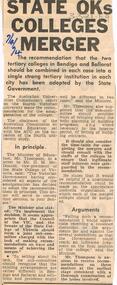
Document - LA TROBE UNIVERSITY BENDIGO COLLECTION: STATE OKS COLLEGES MERGER
... History House 11 Mackenzie Street Bendigo goldfields BENDIGO Education bit and btc merger La Trobe University Bendigo Collection collection Bendigo education tertiary education Bendigo Teachers' College State College of Victoria Bendigo Bendigo Institute of Technology merger Mr. Lindsay Thompson Australian ...A Bendigo 'Advertiser' article titled 'State oks colleges merger'. The State Government has confirmed the merger of the State College of Victoria Bendigo and the Bendigo Institute of Technology. The Australian Universities Commission report recommended the merger of the two colleges. Mr. Lindsay Thompson the Minister for Education has adopted the amalgamation recommendation in principle. 7/4/74bendigo, education, bit and btc merger, la trobe university bendigo collection, collection, bendigo, education, tertiary education, bendigo teachers' college, state college of victoria bendigo, bendigo institute of technology, merger, mr. lindsay thompson, australian universities commission -
 Bendigo Historical Society Inc.
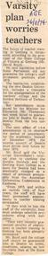
Document - LA TROBE UNIVERSITY BENDIGO COLLECTION: VARSITY PLAN WORRIES TEACHERS
... History House 11 Mackenzie Street Bendigo goldfields BENDIGO Education state college of victoria La Trobe University Bendigo Collection collection State College of Victoria Geelong tertiary education education Mr. David Boyd Australian Universities Commission An 'Age' newspaper article titled 'Varsity plan worries teachers'. The Principal of the State College of Victoria Geelong Mr. David Boyd is concerned about the future of teacher training in Geelong since the legislation establishing the new Deakin University. This to be based on the amalgamation of the local teachers' college and the Gordon Institute of Technology ...An 'Age' newspaper article titled 'Varsity plan worries teachers'. The Principal of the State College of Victoria Geelong Mr. David Boyd is concerned about the future of teacher training in Geelong since the legislation establishing the new Deakin University. This to be based on the amalgamation of the local teachers' college and the Gordon Institute of Technology. 26/11/74.bendigo, education, state college of victoria, la trobe university bendigo collection, collection, state college of victoria geelong, tertiary education, education, mr. david boyd, australian universities commission -
 The Beechworth Burke Museum
Photograph
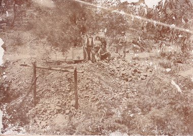
... history...colonial australia...australian gold rushes...mining technology...It has potential to improve our understanding of miners working conditions and the shifting character of mining in the Beechworth district. burke museum beechworth museum beechworth gold fields gold rush victorian gold rush gold ming history colonial australia australian gold rushes mining technology beechworth historic district indigo gold trail migration indigo shire good luck gold mine victorian goldfields mining syndicates gold fever quartz-mining small-scale mining old good luck mine mopoke gully quartz reefs beechworth Obverse: Williams/ Good/ Luck Reverse: A02498/ 1997. 2498/ Good Luck/ Mine/ 1899/ Mopoke. ...This image is a reproduction of an 1899 original depicting the 'Williams Good Luck Mine' on the Mopoke Reef (also called 'Morepork Gully') in the Dingle Ranges, approximately three miles from Beechworth. A large opening to a mine can be seen behind the men in the photograph, with a wheeled cart on a track leading to the men's position, where the soil and rocks have been hauled away. This photograph interestingly contains dogs alongside the miners. While dogs have been recorded as deterrents to thieves in the Victorian goldfields, these dogs appear as companions to these men. Following the discovery of gold at Beechworth in 1852, rushes quickly followed at surrounding creeks and gullies in the district. In the late nineteenth and early twentieth centuries, small syndicates of miners continued to work old or abandoned quartz reefs, often persisting without the assistance of heavy machinery to remove the large amounts of rock, in order to obtain yields at ever greater depths. The group of miners in this photograph are Mr. Roger Williams and Sons, who revived operations at the ‘Old Good Luck’ mine on the Mopoke Reef in the Dingle Range near Beechworth around 1892, working the site for more than two decades. An emigrant from Cornwall with experience in the tin mining industry, 19 year old Roger Williams senior sailed to New Zealand in 1840, then to Australia where he spent time in the Bendigo Gold Fields before settling in Beechworth in the early 1860s. Mr Williams senior worked on various mining activities in the district, including the Rocky Mountain Tunnel project. Conversant with the character of gold-bearing reefs in the area, the syndicate dug an eight hundred foot tunnel, digging down as far down as two hundred feet with little capital save their labour, to connect and provide better working access to the mass of reefs and veins in the vicinity. Progress was hampered by poor air quality charged with fumes from dynamite and large quantities of rock had to be crushed to obtain payable yields. The Victorian Goldfields are filled with ruins and remnants of the area's rich mining history, ranging from small alluvial diggings to the remains of huge mining companies. Site names often changed several times throughout the nineteenth and twentieth centuries. Some sites were abandoned and forgotten, others were worked continuously over many decades. The names of mines were often repeated at different locations throughout the Victorian Goldfields. For example, there is a Mopoke Gully heritage mine near Fryers Creek, Victoria. 'Mopoke' is a common onomatopoeic name for Morepork and Australian Boobook owls.This image has historical, social and research significance for patterns of emigration during of the Victorian Gold Rush, and the historical, social and environmental impacts of mining at Beechworth at the turn of the nineteenth and twentieth centuries. As gold became scarce and government support and large company investment waned, poor hard-working miners laboured intensively to make a living through periods of high unemployment. This image can be compared and studied alongside other historical mining photographs and objects in the Burke Museum Collection. It has potential to improve our understanding of miners working conditions and the shifting character of mining in the Beechworth district.Sepia coloured rectangular photograph printed on gloss photographic paper mounted on card. Obverse: Williams/ Good/ Luck Reverse: A02498/ 1997. 2498/ Good Luck/ Mine/ 1899/ Mopoke. burke museum, beechworth museum, beechworth, gold fields, gold rush, victorian gold rush, gold ming history, colonial australia, australian gold rushes, mining technology, beechworth historic district, indigo gold trail, migration, indigo shire, good luck gold mine, victorian goldfields, mining syndicates, gold fever, quartz-mining, small-scale mining, old good luck mine, mopoke gully, quartz reefs beechworth -
 The Beechworth Burke Museum
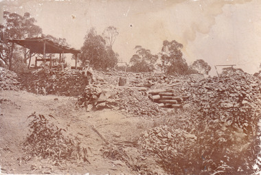
Photograph
... history...colonial australia...australian gold rushes...mining technology...It has potential to improve our understanding of miners working conditions and the shifting character of mining in the Beechworth district. burke museum beechworth museum beechworth gold fields gold rush victorian gold rush gold ming history colonial australia australian gold rushes mining technology beechworth historic district indigo gold trail migration indigo shire good luck gold mine victorian goldfields mining syndicates gold fever quartz-mining small-scale mining old good luck mine mopoke gully quartz reefs beechworth Obverse: Reverse: A02497/ 1997.2497/ 'Good/ Luck/ Mine'/ Morepork/ Gully/ Mrs Joyce/ Bright/ Tunnel/ 800 ft/ 1899. ...This image is a reproduction of an 1899 original depicting the 'Williams Good Luck Mine' on the Mopoke Reef (also called 'Morepork Gully') in the Dingle Ranges, approximately three miles from Beechworth. The foreground of the image is littered with piles of smashed rock and detritus, known as ‘mullock’, beside a reinforced mine shaft, a vertical access passageway allowing miners to enter the mine and haul ore out using lifting technology such as a poppet heads, whims or windlasses. A group of miners and a dog appear close to an open-sided miner’s hut. Following the discovery of gold at Beechworth in 1852, rushes quickly followed at surrounding creeks and gullies in the district. In the late nineteenth and early twentieth centuries, small syndicates of miners continued to work old or abandoned quartz reefs, often persisting without the assistance of heavy machinery to remove the large amounts of rock, in order to obtain yields at ever greater depths. The group of miners in this photograph are Mr. Roger Williams and Sons, who revived operations at the ‘Old Good Luck’ mine on the Mopoke Reef in the Dingle Range near Beechworth around 1892, working the site for more than two decades. An emigrant from Cornwall with experience in the tin mining industry, 19 year old Roger Williams senior sailed to New Zealand in 1840, then to Australia where he spent time in the Bendigo Gold Fields before settling in Beechworth in the early 1860s. Mr Williams senior worked on various mining activities in the district, including the Rocky Mountain Tunnel project. Conversant with the character of gold-bearing reefs in the area, the syndicate dug an eight hundred foot tunnel, digging down as far down as two hundred feet with little capital save their labour, to connect and provide better working access to the mass of reefs and veins in the vicinity. Progress was hampered by poor air quality charged with fumes from dynamite and large quantities of rock had to be crushed to obtain payable yields. The Victorian Goldfields are filled with ruins and remnants of the area's rich mining history, ranging from small alluvial diggings to the remains of huge mining companies. Site names often changed several times throughout the nineteenth and twentieth centuries. Some sites were abandoned and forgotten, others were worked continuously over many decades. The names of mines were often repeated at different locations throughout the Victorian Goldfields. For example, there is a Mopoke Gully heritage mine near Fryers Creek, Victoria. 'Mopoke' is a common onomatopoeic name for Morepork and Australian Boobook owls.This image has historical, social and research significance for patterns of emigration during of the Victorian Gold Rush, and the historical, social and environmental impacts of mining at Beechworth at the turn of the nineteenth and twentieth centuries. As gold became scarce and government support and large company investment waned, poor hard-working miners laboured intensively to make a living through periods of high unemployment. This image can be compared and studied alongside other historical mining photographs and objects in the Burke Museum Collection. It has potential to improve our understanding of miners working conditions and the shifting character of mining in the Beechworth district.Sepia coloured rectangular photograph printed on gloss photographic paper mounted on card.Obverse: Reverse: A02497/ 1997.2497/ 'Good/ Luck/ Mine'/ Morepork/ Gully/ Mrs Joyce/ Bright/ Tunnel/ 800 ft/ 1899. burke museum, beechworth museum, beechworth, gold fields, gold rush, victorian gold rush, gold ming history, colonial australia, australian gold rushes, mining technology, beechworth historic district, indigo gold trail, migration, indigo shire, good luck gold mine, victorian goldfields, mining syndicates, gold fever, quartz-mining, small-scale mining, old good luck mine, mopoke gully, quartz reefs beechworth -
 The Beechworth Burke Museum
Photograph, c. 1870
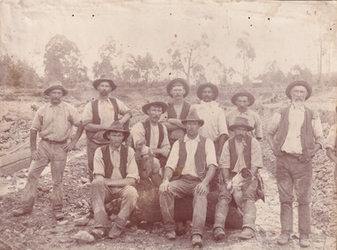
... history of Victoria and therefore, images like this one which portray an open cut sluicing site can reveal important information for society and technology for the date when the photograph was taken. This image is of important historical significance for its ability to convey information about sluicing and the methods used to find gold in the late 1800s and early 1900s. It also shows a location where sluicing was undertook which provides insight into the impact of sluicing on the environment at a time when it was done. Images, like this one, of Australian ...This photograph was captured at an undisclosed location and at an unidentified time but likely dates to approximately 1870. The photographer's details are not recorded and the identities of the men in the image are also not known. This image depicts a group of 10 men in typical miners fashion. Four of them are sat on a large log with one holding a small dog. Six miners stand behind those sitting. All these men are wearing a white button-up shirt and tan coloured work trousers. They wear heavy boots and seven have included a dark vest over their shirt. The man holding the dog has a pipe in his mouth. Two of these men are clean shaven with the remainder sporting a moustache and two with a beard. The ages of these men vary from late 20s to middle age. This group of men are located in a mining location with what appears to be an open cut mine in the background of the image. The ground is muddy and has elements which can help identify it as a mining location based on the condition of the landscape. The bottom of the men's trousers are muddy which provides the assurance that these men were working in this location when their photograph was captured. In the background there is one structure, possibly a dwelling, and bush which identifies the location as Australia. Open cut sluicing is a method used to extract gold and other precious metals from beneath the surface of the earth. This technique involved the use of high-powered hoses which broke down the soil enabling miners to come along and search this soil for gold. After the gold rush of the early 1850s, diggers had to enlist the assistance of heavy machinery and techniques like hydraulic sluicing in order to reach gold because the surface alluvial gold had already been discovered and removed. This heavy machinery was not used until after 1853. The search for gold is ingrained into the history of Victoria and therefore, images like this one which portray an open cut sluicing site can reveal important information for society and technology for the date when the photograph was taken. This image is of important historical significance for its ability to convey information about sluicing and the methods used to find gold in the late 1800s and early 1900s. It also shows a location where sluicing was undertook which provides insight into the impact of sluicing on the environment at a time when it was done. Images, like this one, of Australian gold rush history can reveal important information about the social and environmental impact of this period. This image depicts diggers standing in a mining location and therefore, this image has the capacity to reveal or support significant information for researchers studying the fashion and social status of diggers in Australia in approximately 1870. It can also provide information on the landscape of Australia in this period and the impact of mining for gold on both society and the Australian landscape. The Burke Museum is home to a substantial collection of Australian mining photographs which can be used to gain a deeper understanding into life on the gold fields, technology used in mining, the miners themselves and the impact of the gold digging on the environment.Sepia toned rectangular photograph printed on matte photographic paper mounted on board.Reverse: 1997.2518mining, goldfields, beechworth, 1870, australia, australian goldfields, diggers, victoria, sluicing, gold mining, miners, diggers victoria -
 The Beechworth Burke Museum
Photograph, c.1870
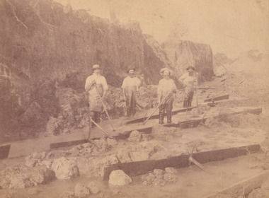
... history of Victoria and therefore, images like this one which portray an open cut sluicing site can reveal important information for society and technology for the date when the photograph was taken. This image is of important historical significance for its ability to convey information about sluicing and the methods used to find gold in the late 1800s and early 1900s. It also shows a location where sluicing was undertook which provides insight into the impact of sluicing on the environment at a time when it was done. Images, like this one, of Australian ...This photograph was taken in approximately 1870 and depicts four male miners standing in mining sluice at the Three Mile Goldfields. These men are wearing typical attire for 1870s gold miners. They wear white shirts, tan coloured pants with water proof shoes and most of the men are wearing an apron to prevent their clothing from becoming too dirty from the mud. Each man is wearing a wide brim hat and hold large wooden tools used for sorting through the sluice. Three of the four men have full beards. The photograph was donated to the Burke Museum by R. Ziegenbein before 2001 but the photographer and the individuals captured in the photo are unknown. The image depicts the landscape of the Three Mile Goldfields during a period when open cut sluicing was undertaken to reach gold. Open cut sluicing is a method used to extract gold and other precious metals from beneath the surface of the earth. This technique involved the use of high-powered hoses which broke down the soil enabling miners to come along and search this soil for gold. After the gold rush of the early 1850s, diggers had to enlist the assistance of heavy machinery and techniques like hydraulic sluicing in order to reach gold because the surface alluvial gold had already been discovered and removed. This heavy machinery was not used until after 1853. The Three Mile Goldfields was a site of rich alluvial gold deposits located about 5 km south of Beechworth in Victoria. Today, the location of this gold deposit is called Baarmutha. It was a popular area for gold mining in the 1850s but became largely abandoned by the following decade. In 1865, a man named John Pund recognized that the area could be potentially rich if a better water supply could be obtained. He secured a 15 year license with three other miners. Within the next five years, these men had constructed 19 km of water race going from Upper Nine Mile Creek to Three Mile Creek. By 1881, these four men had delivered 950,000 gallons to the Three Mile Sluicing area which is depicted in this photograph. Pund was later go into partnership with John Alston Wallace who would become owner of the Star Hotel in Beechworth. The Three Mile sluicing location continued to be operational until 1950. Sluice box workers were a vital part of gold mining regardless of how inefficient they were in the recovery of gold. After using hydraulic sluicing to cut away the earth, miners would use the big wooden boxes depicted in the image to catch the earth which would then be sifted for gold. However, accidents would occur often which would result in the gold washing away and unable to be recovered. It was not a very efficient system because the gold, which was alluvial and thus very fine, would often pass through the sluice box undetected.The search for gold is ingrained into the history of Victoria and therefore, images like this one which portray an open cut sluicing site can reveal important information for society and technology for the date when the photograph was taken. This image is of important historical significance for its ability to convey information about sluicing and the methods used to find gold in the late 1800s and early 1900s. It also shows a location where sluicing was undertook which provides insight into the impact of sluicing on the environment at a time when it was done. Images, like this one, of Australian gold rush history can reveal important information about the social and environmental impact of this period. This image depicts diggers standing in a mining location and therefore, this image has the capacity to reveal or support significant information for researchers studying the fashion and social status of diggers in Australia in approximately 1870. It can also provide information on the landscape of Australia in this period and the impact of mining for gold on both society and the Australian landscape. The Burke Museum is home to a substantial collection of Australian mining photographs which can be used to gain a deeper understanding into life on the gold fields, technology used in mining, the miners themselves and the impact of the gold digging on the environment.Sepia toned rectangular photograph printed on matte photographic paper and mounted on board.[illegible] about 1870 / 97 2514.1 / 2594 30three mile goldfields, goldfields, 1870, 1870 gold, australia, australian landscape, miners, gold miners, diggers, gold diggers, beechworth, victoria, sluice box workers, sluicing, sluice, mining -
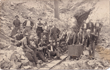
 The Beechworth Burke Museum
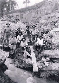
Photograph - Photograph - Reproduction, W. D. Gibbon, Early 1900s
... history of Victoria and therefore, images like this one which portray an open cut sluicing site can reveal important information for society and technology for the date when the photograph was taken. This image is of important historical significance for its ability to convey information about sluicing and the methods used to find gold in the late 1800s and early 1900s. It also shows a location where sluicing was undertook which provides insight into the impact of sluicing on the environment at a time when it was done. Images, like this one, of Australian ...This photograph was taken in 1911 at Three Mile Creek, about five kilometers south of Beechworth town. Significant digging took place at this location from late 1855, which led to a flood of workers and stores to follow, though daily earnings were slim compared to the nearby Woolshed site. This remained the case even after workers at Three Mile Creek attempted to protest around Beechworth during an election in November 1855. Three Mile Creek was one of seven significant divisions of the Beechworth Mining District formalised by the Governor-in-Council in 1858, though by the time this photograph was taken, the boundaries of the original seven districts had shifted to create seventeen divisions. The Three Mile Goldfields was a site of rich alluvial gold deposits located about 5km south of Beechworth in Victoria. Today, the location of this gold deposit is called Baarmutha. It was a popular area for gold mining in the 1850s but became largely abandoned by the following decade. In 1865, a man named John Pund (a man second from the left in the back row of this photograph shares this surname) recognized that the area could be potentially rich if a better water supply could be obtained. He secured a 15 year license with three other miners. Within the next five years, these men had constructed 19 km of water race going from Upper Nine Mile Creek to Three Mile Creek. By 1881, these four men had delivered 950,000 gallons to the Three Mile Sluicing area which is depicted in this photograph. Pund would later go into partnership with John Alston Wallace who would become owner of the Star Hotel in Beechworth. The Three Mile sluicing location continued to be operational until 1950. The eleven miners in this photograph are: Back row: Led Guthrie, P. Pund, F. Beel, [Unknown] Miller Front row: Paddy McNamara, J. King, W. Beel, [Unknown] Garland, J. Clarke, J. Ryan, H. Bartsh In the background of the photograph is a huge dirt wall that appears to suffer damage caused by hydraulic sluicing. Hydraulic sluicing is a specialised mining technique that involves directing high pressure water flows at dirt to uncover gold. The technique played a significant role in shaping Beechworth's landscape during the gold rush to create the topography seen today.The search for gold is ingrained into the history of Victoria and therefore, images like this one which portray an open cut sluicing site can reveal important information for society and technology for the date when the photograph was taken. This image is of important historical significance for its ability to convey information about sluicing and the methods used to find gold in the late 1800s and early 1900s. It also shows a location where sluicing was undertook which provides insight into the impact of sluicing on the environment at a time when it was done. Images, like this one, of Australian gold rush history can reveal important information about the social and environmental impact of this period. This image depicts diggers standing in a mining location and therefore, this image has the capacity to reveal or support significant information for researchers studying the fashion and social status of diggers in Australia in approximately 1911. It can also provide information on the landscape of Australia in this period and the impact of mining for gold on both society and the Australian landscape. The Burke Museum is home to a substantial collection of Australian mining photographs which can be used to gain a deeper understanding into life on the gold fields, technology used in mining, the miners themselves and the impact of the gold digging on the environment.Black and white / sepia rectangular reproduced photograph printed on glossy photographic paper mounted on board.beechworth, beechworth museum, mining, mining team, three mile creek, sluicing, hydraulic sluicing, photography, gold sluicing, gold mining, pund mining -
 The Beechworth Burke Museum
Photograph - Photograph - Reproduction, 1890-1900
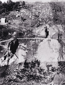
... history of Victoria and therefore, images like this one which portray an open cut sluicing site can reveal important information for society and technology for the date when the photograph was taken. This image is of important historical significance for its ability to convey information about sluicing and the methods used to find gold in the late 1800s and early 1900s. It also shows a location where sluicing was undertook which provides insight into the impact of sluicing on the environment at a time when it was done. The Burke Museum is home to a substantial collection of Australian ...The photograph appears to depict the of the entrance to the Rocky Mountain Tunnel. The Rocky Mountain Tunnel runs from opening of the tunnel, underneath the Beechworth town, to the Gorge. This tunnel drained the excess water from the upper Spring Creek Goldfield to allow for mining access in the area. The Rocky Mountain Co. blasted through the granite rock to create the original 400ft-long tunnel in 1859, but between 1867 and 1871, the Rocky Mountain Gold Sluicing Co. widened and extended it. At its completion, it measured 14ft deep, 6ft wide, and almost half a mile long. The mining surveyor at Beechworth called it 'without doubt, the greatest undertaking of the kind in the colony'. When the company became the Rocky Mountain Extended Gold Sluicing Co. in the mid-1870s, they continued the tunnelling work. The work was reportedly vital to mining being able to continue at Beechworth and may have established world records in tunnelling through hard rock. The entrance at the Gorge side of the tunnel can be seen from the Beechworth Gorge Walk. The tunnel continues to be an outfall drain for the lake and the town.The search for gold is ingrained into the history of Victoria and therefore, images like this one which portray an open cut sluicing site can reveal important information for society and technology for the date when the photograph was taken. This image is of important historical significance for its ability to convey information about sluicing and the methods used to find gold in the late 1800s and early 1900s. It also shows a location where sluicing was undertook which provides insight into the impact of sluicing on the environment at a time when it was done. The Burke Museum is home to a substantial collection of Australian mining photographs which can be used to gain a deeper understanding into life on the gold fields, technology used in mining, the miners themselves and the impact of the gold digging on the environment.A black and white rectangular reproduced photograph printed on matte photographic paper.7814beechworth, beechworth museum, burke museum, australian museum, mining, rocky mountain mining co., rocky mountain mining company, mine, mining company, rocky mountain mine, mine entrance, rocky mountain, gold, gold mining -
 The Beechworth Burke Museum
Photograph - Photograph - Reproduction, Unknown
... history...colonial australia...australian gold rushes...mining technology...It has potential to improve our understanding of miners working conditions and the shifting character of mining in the Beechworth district. burke museum beechworth museum beechworth gold fields gold rush victorian gold rush gold ming history colonial australia australian gold rushes mining technology beechworth historic district indigo gold trail migration indigo shire good luck gold mine victorian goldfields mining syndicates gold fever quartz-mining small-scale mining old good luck mine mopoke gully quartz reefs beechworth Obverse: Williams Good Luck Mine Beechworth / Roger! ...This image is a reproduction of an 1899 original depicting the 'Williams Good Luck Mine' on the Mopoke Reef (also called 'Morepork Gully') in the Dingle Ranges, approximately three miles from Beechworth. The foreground of the image is littered with piles of smashed rock and detritus, known as ‘mullock’, beside a reinforced mine shaft, a vertical access passageway allowing miners to enter the mine and haul ore out using lifting technology such as a poppet heads, whims or windlasses. A group of miners and a dog appear close to an open-sided miner’s hut. Following the discovery of gold at Beechworth in 1852, rushes quickly followed at surrounding creeks and gullies in the district. In the late nineteenth and early twentieth centuries, small syndicates of miners continued to work old or abandoned quartz reefs, often persisting without the assistance of heavy machinery to remove the large amounts of rock, in order to obtain yields at ever greater depths. The group of miners in this photograph are Mr. Roger Williams and Sons, who revived operations at the ‘Old Good Luck’ mine on the Mopoke Reef in the Dingle Range near Beechworth around 1892, working the site for more than two decades. An emigrant from Cornwall with experience in the tin mining industry, 19 year old Roger Williams senior sailed to New Zealand in 1840, then to Australia where he spent time in the Bendigo Gold Fields before settling in Beechworth in the early 1860s. Mr Williams senior worked on various mining activities in the district, including the Rocky Mountain Tunnel project. Conversant with the character of gold-bearing reefs in the area, the syndicate dug an eight hundred foot tunnel, digging down as far down as two hundred feet with little capital save their labour, to connect and provide better working access to the mass of reefs and veins in the vicinity. Progress was hampered by poor air quality charged with fumes from dynamite and large quantities of rock had to be crushed to obtain payable yields. The Victorian Goldfields are filled with ruins and remnants of the area's rich mining history, ranging from small alluvial diggings to the remains of huge mining companies. Site names often changed several times throughout the nineteenth and twentieth centuries. Some sites were abandoned and forgotten, others were worked continuously over many decades. The names of mines were often repeated at different locations throughout the Victorian Goldfields. For example, there is a Mopoke Gully heritage mine near Fryers Creek, Victoria. 'Mopoke' is a common onomatopoeic name for Morepork and Australian Boobook owls. This image has historical, social and research significance for patterns of emigration during of the Victorian Gold Rush, and the historical, social and environmental impacts of mining at Beechworth at the turn of the nineteenth and twentieth centuries. As gold became scarce and government support and large company investment waned, poor hard-working miners laboured intensively to make a living through periods of high unemployment. This image can be compared and studied alongside other historical mining photographs and objects in the Burke Museum Collection. It has potential to improve our understanding of miners working conditions and the shifting character of mining in the Beechworth district. Black and white rectangular reproduction photograph printed on matte photographic paper.Obverse: Williams Good Luck Mine Beechworth / Roger! / Reverse: 6858 / burke museum, beechworth museum, beechworth, gold fields, gold rush, victorian gold rush, gold ming history, colonial australia, australian gold rushes, mining technology, beechworth historic district, indigo gold trail, migration, indigo shire, good luck gold mine, victorian goldfields, mining syndicates, gold fever, quartz-mining, small-scale mining, old good luck mine, mopoke gully, quartz reefs beechworth -
 The Beechworth Burke Museum
Postcard, 1914-1916
... history of Victoria and therefore, images like this one can reveal important information for society and technology for the date when the photograph was taken. It also shows a location where reef mining was undertaken which provides insight into the impact on the environment at a time when it was done. everton mine mining goldrush postcard Burke Museum Black and white photograph mining trolley post card/correspondence address only/ Kodak Australia/1914 A sepia toned rectangular postcard printed on photographic paper Postcard Postcard ...This postcard shows a group of men standing outside of the Everton mine alongside a mining trolley sitting on tracks. The search for gold is ingrained into the history of Victoria and therefore, images like this one can reveal important information for society and technology for the date when the photograph was taken. It also shows a location where reef mining was undertaken which provides insight into the impact on the environment at a time when it was done.A sepia toned rectangular postcard printed on photographic paperpost card/correspondence address only/ Kodak Australia/1914everton mine, mining, goldrush, postcard, burke museum, black and white, photograph, mining trolley -
 The Beechworth Burke Museum
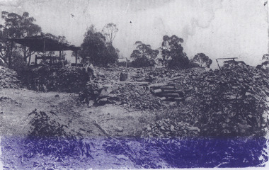
Photograph, Unknown
... history...colonial australia...australian gold rushes...mining technology...The photograph contributes to our understanding of the A1 Gold Mine's impact on the landscape and the social, environmental impacts of mining on communities and may be compared with others in the Burke Museum's extensive collection of mining photographs to deepen our understanding of mining in the Jamieson area. burke museum beechworth museum beechworth gold fields gold rush victorian gold rush mining tunnels gold ming history colonial australia australian gold rushes mining technology beechworth historic district indigo gold trail indigo shire upper goulburn shire jamieson woods point-walhalla goldfield a1 gold mine victorian high country modern mining methods orogenic gold province gold mineralisation devonian dykes Reverse: 5577 / A1 Mine / Near Jamieson / Vic. / Black and white rectangular photograph printed on photographic paper Photograph Photograph ...The A1 Gold Mine is located north of Woods Point, near Jamieson, in the Upper Goulburn region of Victoria. Gold was discovered at the A1 site in 1861 and mining operations began in 1864. The A1 Mine Settlement refers to a small township known variously as Castle Reef, Castle Point, and Raspberry Creek, which developed in the 1860s around mining industry centred on a crushing machine that worked the three gold reefs in the area. Historically, the name "A1"referred to the high quality of gold found in the quartz reefs at depths of at least two thousand feet. Along with the Morning Star mine at Woods Point, the A1 gold mine produced almost sixty percent of Victoria's gold output in the 1950s to 1970s and continued operating until 1992 when it went into administration. Operations at the site were revived in 2016 and the A1 Mine is now considered one of Victoria's premier gold mines. The A1 mine is part of the extensive and prospective Lachlan Fold Belt, a north-west trending belt of tightly folded Early Devonian sedimentary rocks extending from New South Wales to Victoria. Mineralisation is hosted within or immediately adjacent to diorite dykes. Contemporary development of the 'Queens Lode' at the A1 mine signals a move from high-grade, narrow vein airleg mining into larger scale, mechanical mining designed to increase ore production volume. This original, undated photograph of the A1 Mine appears to depict an area or phase of disuse or abandonment. The aged and humble appearance of the cottage suggests association with the historical A1 Mine Settlement, therefore the image may have been taken prior to the 1950s-1970s revival period in which the A1 mine is known to have produced high gold yields. The photograph contributes to our understanding of the A1 Gold Mine's impact on the landscape and the social, environmental impacts of mining on communities and may be compared with others in the Burke Museum's extensive collection of mining photographs to deepen our understanding of mining in the Jamieson area.Black and white rectangular photograph printed on photographic paperReverse: 5577 / A1 Mine / Near Jamieson / Vic. /burke museum, beechworth museum, beechworth, gold fields, gold rush, victorian gold rush, mining tunnels, gold ming history, colonial australia, australian gold rushes, mining technology, beechworth historic district, indigo gold trail, indigo shire, upper goulburn shire, jamieson, woods point-walhalla goldfield, a1 gold mine, victorian high country, modern mining methods, orogenic gold province, gold mineralisation, devonian, dykes