Showing 41825 items matching the%20women%E2%80%99s%20suffrage%20petition
-
 Dutch Australian Heritage Centre Victoria
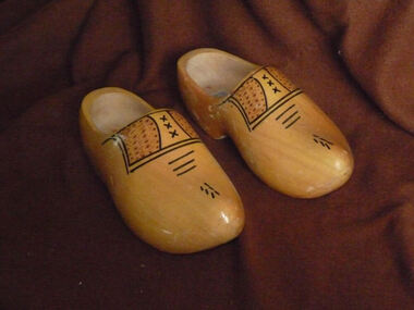
Footwear - Clogs, Company with markings V Z, where the V is located above the Z
... Company with markings V Z, where the V is located above the...The Netherlands ...Wooden shoes are / have been widely used in North-Western Europe (Scandinavia, parts of Germany, UK, The Netherlands, Belgium and Northern France). The models vary from a wooden sole and toe covering (Scandinavia, UK, Northern France) to a complete cover of the whole foot (The Netherlands and parts of Belgium). They are mostly made from poplar wood, but occasionally also from other softwoods like willow. The clogs' finish varies from plain wood or carved wood to varnished or painted versions, often with decorations. Nowadays special models are made for tourists with pictures of Dutch landscapes, tulips or windmills.Although wooden shoes are also used in other countries, the full foot covering model has become one of the symbols of the Netherlands, like the tulips and the old style houses in towns like Amsterdam.Pair of male size wooden clogs - completely covering feet, finished with clear varnish and shoe lace like decorations.Brand indication V Z clog and size 43/44 = 28 1/2cm - Shoe laces like decorations.wooden shoes holland dutch traditional clothing -
 RMIT GSBL Justice Smith Collection
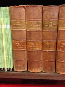
Journal series, Bulwer, J. R, The law reports : court of common pleas, 1866
... The law reports : court of common pleas...The Council of Law Reporting ...Previous owners: T. H. Smith, T. W. SmithNo. of volumes: 15 Volume range: Vol. 1 (1865-66) - Vol. 10 (1874-75) & Vol. 1 (1875-76) - Vol. 5 (1879-80) law reports; digests; etc. -- great britain, law reports; digests; etc. -- great britain -- periodicals -
 Greensborough Historical Society
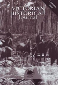
Journal, Victorian Historical Journal Vol. 80 no. 2, November 2009- (incomplete), 01/11/2009
Journal of the Royal Historical Society of Victoria Black and white illus.royal historical society of victoria, victoria history -
 Federation University Historical Collection
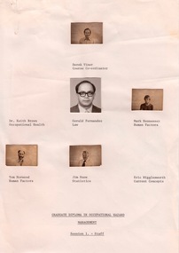
Photograph - Photographs - Black and White, VIOSH: Graduate Diploma in Occupational Hazard Management - Session 1 Staff, 1979/80
Victorian Institute of Occupational Safety and Health (VIOSH) Australia is the Asia-Pacific centre for teaching and research in occupational health and safety (OHS) and is known as one of Australia's leaders on the field. VIOSH has a global reputation for its innovative approach within the field of OHS management. VIOSH had its first intake of students in 1979. At that time the Institution was known as the Ballarat College of Advanced Education. In 1990 it became known as Ballarat University College, then in 1994 as University of Ballarat. It was 2014 that it became Federation University. VIOSH Australia students are safety managers, senior advisors and experienced OHS professionals. They come from all over Australia and industry. Students are taught active research and enquiry; rather than textbook learning and a one-size fits all approach. VIOSH accepts people into the Graduate Diploma of Occupational Hazard Management who have no undergraduate degree - on the basis of extensive work experience and knowledge. Page shows the image of most and the name and position of seven members of staff responsible for the Graduate Diploma in Occupational Hazard Management Course - Session 1. Derek Viner - Course Co-ordinator; Dr Keith Brown - Occupational Health; Gerald Fernandez - Law; Mark Hennessey - Human Factors; Tom Norwood - Human Factors; Jim Snow - Statistics and Eric Wigglesworth - Current Concepts.Small black and white photos stuck on A4 page. Names and positions under eachNames viosh, victorian institute of occupational safety and health, graduate diploma in occupational hazard management, session 1 staff, derek viner, course co-ordinator, dr keith brown, occupational health, gerald fernandez, law, mark hennessey, human factors, tom norwood, jim snow, statistics, eric wigglesworth, current concepts -
 Ringwood and District Historical Society
Legal record - Conditions of Sale (C.E.Carter), Ringwood - Lots 80 & 81 ,Plan of Subdivision No 9473, D Miller to A Needham, 1929
Particulars and Conditions of Sale of Property , from Doris Miller to Alice Needham. -
 Ringwood and District Historical Society
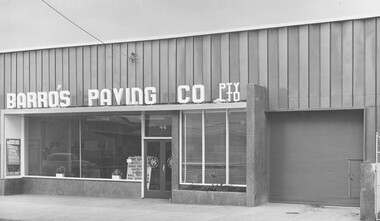
Photograph, Barro's Paving Company Pty Ltd, Ringwood c1970-80's
Barro's Paving Co Building, 46 Maroondah Hwy Ringwood. South Side near New St. 1970-1980'sBack of photograph is stamped, "John Gallagher, Photographer 4 Benares St., Mitcham, Vic WU2568." -
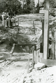
 Ringwood and District Historical Society
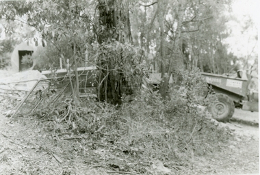
Photographs, 1979-80 MMBW pipe line project at Hubbard Reserve, North Ringwood � Boring mole pit
E560 N5 Dec 1979 A43 Boring mole pit near big box tree in 39 Burlock Avenue backyard Part of a 43-photo record of the MMBW�s engineering feat in drilling a 12 inch pipe line up to 40 feet deep through rock hardened by volcanic action associated with geological fault that occurs along the line. The work took place from October 1979 to May 1980 on the southern boundary of Hubbard Reserve, North Ringwood. The collection was presented to the Ringwood Historical Research Group by J Clarke on 9th June 1980. -
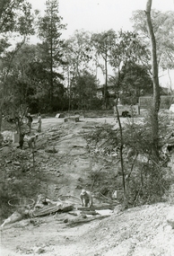
 Ringwood and District Historical Society
Photographs, 1979-80 MMBW pipe line project at Hubbard Reserve, North Ringwood � Back-hoe at pit
E560 N6 Dec 1979 A43 The back-hoe works on the beginnings of pit in 39 Burlock Avenue backyard Part of a 43-photo record of the MMBW�s engineering feat in drilling a 12 inch pipe line up to 40 feet deep through rock hardened by volcanic action associated with geological fault that occurs along the line. The work took place from October 1979 to May 1980 on the southern boundary of Hubbard Reserve, North Ringwood. The collection was presented to the Ringwood Historical Research Group by J Clarke on 9th June 1980. -
 Ringwood and District Historical Society
Photographs, 1979-80 MMBW pipe line project at Hubbard Reserve, North Ringwood � Cover of mole pit
E560 N24 Jan 1980 A43 Cover of mole pit near big box tree in 39 Burlock Avenue backyard Part of a 43-photo record of the MMBW�s engineering feat in drilling a 12 inch pipe line up to 40 feet deep through rock hardened by volcanic action associated with geological fault that occurs along the line. The work took place from October 1979 to May 1980 on the southern boundary of Hubbard Reserve, North Ringwood. The collection was presented to the Ringwood Historical Research Group by J Clarke on 9th June 1980. -
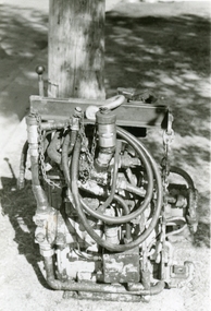
 Ringwood and District Historical Society
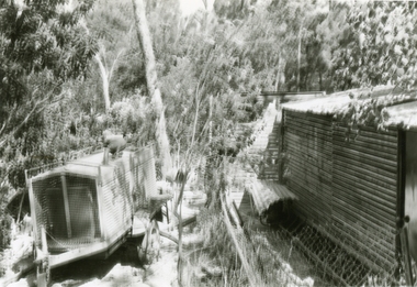
Photographs, 1979-80 MMBW pipe line project at Hubbard Reserve, North Ringwood � Compressor unit in backyard
Part of a 43-photo record of the MMBW�s engineering feat in drilling a 12 inch pipe line up to 40 feet deep through rock hardened by volcanic action associated with geological fault that occurs along the line. The work took place from October 1979 to May 1980 on the southern boundary of Hubbard Reserve, North Ringwood. The collection was presented to the Ringwood Historical Research Group by J Clarke on 9th June 1980.E560 N23 Jan 1980 A43 Compressor unit in backyard of 39 Burlock Avenue -
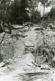
 Ringwood and District Historical Society
Photographs, 1979-80 MMBW pipe line project at Hubbard Reserve, North Ringwood � Work on boring mole pit
Part of a 43-photo record of the MMBW�s engineering feat in drilling a 12 inch pipe line up to 40 feet deep through rock hardened by volcanic action associated with geological fault that occurs along the line. The work took place from October 1979 to May 1980 on the southern boundary of Hubbard Reserve, North Ringwood. The collection was presented to the Ringwood Historical Research Group by J Clarke on 9th June 1980.E560 N22Jan 1980 A43 Work on mole boring pit in 39 Burlock Avenue backyard -
 Ringwood and District Historical Society
Photographs, 1979-80 MMBW pipe line project at Hubbard Reserve, North Ringwood � Filling at 29 Burlock Avenue
Part of a 43-photo record of the MMBW�s engineering feat in drilling a 12 inch pipe line up to 40 feet deep through rock hardened by volcanic action associated with geological fault that occurs along the line. The work took place from October 1979 to May 1980 on the southern boundary of Hubbard Reserve, North Ringwood. The collection was presented to the Ringwood Historical Research Group by J Clarke on 9th June 1980.E560 N10 Dec 1979 A43 Filling at 29 Burlock Avenue -
 Ringwood and District Historical Society
Photographs, 1979-80 MMBW pipe line project at Hubbard Reserve, North Ringwood � Filling behind 29 Burlock Avenue just off sewer line
Part of a 43-photo record of the MMBW�s engineering feat in drilling a 12 inch pipe line up to 40 feet deep through rock hardened by volcanic action associated with geological fault that occurs along the line. The work took place from October 1979 to May 1980 on the southern boundary of Hubbard Reserve, North Ringwood. The collection was presented to the Ringwood Historical Research Group by J Clarke on 9th June 1980.E560 N9 Dec 1979 A43 Filling behind 29 Burlock Avenue just off sewer line -
 Ringwood and District Historical Society
Photographs, 1979-80 MMBW pipe line project at Hubbard Reserve, North Ringwood � Filling at 29 Burlock Avenue
Part of a 43-photo record of the MMBW�s engineering feat in drilling a 12 inch pipe line up to 40 feet deep through rock hardened by volcanic action associated with geological fault that occurs along the line. The work took place from October 1979 to May 1980 on the southern boundary of Hubbard Reserve, North Ringwood. The collection was presented to the Ringwood Historical Research Group by J Clarke on 9th June 1980.E560 N11 Dec 1979 A43 Filling at 29 Burlock Avenue -
 Ringwood and District Historical Society
Photographs, 1979-80 MMBW pipe line project at Hubbard Reserve, North Ringwood � Closeup of revolving airwinch near Hibberd's house
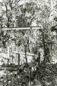
Part of a 43-photo record of the MMBW�s engineering feat in drilling a 12 inch pipe line up to 40 feet deep through rock hardened by volcanic action associated with geological fault that occurs along the line. The work took place from October 1979 to May 1980 on the southern boundary of Hubbard Reserve, North Ringwood. The collection was presented to the Ringwood Historical Research Group by J Clarke on 9th June 1980.E560 N31 Jan 1980 A43 Closeup of revolving airwinch near Hibberd's house -
 Ringwood and District Historical Society
Photographs, 1979-80 MMBW pipe line project at Hubbard Reserve, North Ringwood � Grating over hole in Chalkley's 41 Burlock Avenue
Part of a 43-photo record of the MMBW�s engineering feat in drilling a 12 inch pipe line up to 40 feet deep through rock hardened by volcanic action associated with geological fault that occurs along the line. The work took place from October 1979 to May 1980 on the southern boundary of Hubbard Reserve, North Ringwood. The collection was presented to the Ringwood Historical Research Group by J Clarke on 9th June 1980.E560 N25 Jan 1980 A43 Grating over hole 37 feet deep in Chalkley's 41 Burlock Avenue (lot 8) -
 Ringwood and District Historical Society
Photographs, 1979-80 MMBW pipe line project at Hubbard Reserve, North Ringwood � View along line work in Hibberd's and Chalkley's
Part of a 43-photo record of the MMBW�s engineering feat in drilling a 12 inch pipe line up to 40 feet deep through rock hardened by volcanic action associated with geological fault that occurs along the line. The work took place from October 1979 to May 1980 on the southern boundary of Hubbard Reserve, North Ringwood. The collection was presented to the Ringwood Historical Research Group by J Clarke on 9th June 1980.E560 N27 Jan 1980 A43 View along line work in Hibberd's and Chalkley's (lot 9 and 8) -
 Ringwood and District Historical Society
Photographs, 1979-80 MMBW pipe line project at Hubbard Reserve, North Ringwood � Truck-mounted posthole digger that tried to sink shafts on MMBW sewer line behind 29-39 Burlock Avenue
Part of a 43-photo record of the MMBW�s engineering feat in drilling a 12 inch pipe line up to 40 feet deep through rock hardened by volcanic action associated with geological fault that occurs along the line. The work took place from October 1979 to May 1980 on the southern boundary of Hubbard Reserve, North Ringwood. The collection was presented to the Ringwood Historical Research Group by J Clarke on 9th June 1980.E560 N32 Feb 1980 A43 Truck-mounted posthole digger that tried to sink shafts on MMBW sewer line behind 29-39 Burlock Avenue. Four feet wide, the auger could only go down one metre and was nearly useless. -
 Ringwood and District Historical Society
Photographs, 1979-80 MMBW pipe line project at Hubbard Reserve, North Ringwood � Line of sewer work with mole power pack near Hibberd's shed
Part of a 43-photo record of the MMBW�s engineering feat in drilling a 12 inch pipe line up to 40 feet deep through rock hardened by volcanic action associated with geological fault that occurs along the line. The work took place from October 1979 to May 1980 on the southern boundary of Hubbard Reserve, North Ringwood. The collection was presented to the Ringwood Historical Research Group by J Clarke on 9th June 1980.E560 N28 Jan 1980 A43 Line of sewer work with mole power pack near Hibberd's shed -
 Ringwood and District Historical Society
Photographs, 1979-80 MMBW pipe line project at Hubbard Reserve, North Ringwood � View east, sewer work line showing grate over pit
Part of a 43-photo record of the MMBW�s engineering feat in drilling a 12 inch pipe line up to 40 feet deep through rock hardened by volcanic action associated with geological fault that occurs along the line. The work took place from October 1979 to May 1980 on the southern boundary of Hubbard Reserve, North Ringwood. The collection was presented to the Ringwood Historical Research Group by J Clarke on 9th June 1980.E560 N30 Feb 1980 A43 View east, sewer work line showing grate over pit -
 Ringwood and District Historical Society
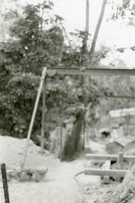
Photographs, 1979-80 MMBW pipe line project at Hubbard Reserve, North Ringwood � Swivel crane over first hole west of boring pit in 39 Burlock Avenue
Part of a 43-photo record of the MMBW�s engineering feat in drilling a 12 inch pipe line up to 40 feet deep through rock hardened by volcanic action associated with geological fault that occurs along the line. The work took place from October 1979 to May 1980 on the southern boundary of Hubbard Reserve, North Ringwood. The collection was presented to the Ringwood Historical Research Group by J Clarke on 9th June 1980.E561 N3 Feb 1980 A43 Swivel crane over first hole west of boring pit in 39 Burlock Avenue. The track used to reach Burlock Avenue on left. -
 Ringwood and District Historical Society
Photographs, 1979-80 MMBW pipe line project at Hubbard Reserve, North Ringwood � View along MMBW work line in east end of Hibberd's, showing grating over mole boring pit
Part of a 43-photo record of the MMBW�s engineering feat in drilling a 12 inch pipe line up to 40 feet deep through rock hardened by volcanic action associated with geological fault that occurs along the line. The work took place from October 1979 to May 1980 on the southern boundary of Hubbard Reserve, North Ringwood. The collection was presented to the Ringwood Historical Research Group by J Clarke on 9th June 1980.E560 N29 Feb 1980 A43 View along MMBW work line in east end of Hibberd's, showing grating over mole boring pit -
 Ringwood and District Historical Society
Photographs, 1979-80 MMBW pipe line project at Hubbard Reserve, North Ringwood � First hole in Lot 8
Part of a 43-photo record of the MMBW�s engineering feat in drilling a 12 inch pipe line up to 40 feet deep through rock hardened by volcanic action associated with geological fault that occurs along the line. The work took place from October 1979 to May 1980 on the southern boundary of Hubbard Reserve, North Ringwood. The collection was presented to the Ringwood Historical Research Group by J Clarke on 9th June 1980.E561 N2 Feb 1980 A43 Final hole in lot 8 (no. 41) at the corner of Chalkly's -
 Ringwood and District Historical Society
Photographs, 1979-80 MMBW pipe line project at Hubbard Reserve, North Ringwood � Boring hole in lot 7
Part of a 43-photo record of the MMBW�s engineering feat in drilling a 12 inch pipe line up to 40 feet deep through rock hardened by volcanic action associated with geological fault that occurs along the line. The work took place from October 1979 to May 1980 on the southern boundary of Hubbard Reserve, North Ringwood. The collection was presented to the Ringwood Historical Research Group by J Clarke on 9th June 1980.E561 N4 Feb 1980 A43 The boring hole, 39' deep, at lot 7 (Clarke's, 39 Burlock Ave) with the generator used to supply light. -
 Ringwood and District Historical Society
Photographs, 1979-80 MMBW pipe line project at Hubbard Reserve, North Ringwood � compressor
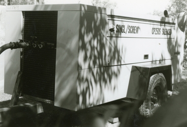
Part of a 43-photo record of the MMBW�s engineering feat in drilling a 12 inch pipe line up to 40 feet deep through rock hardened by volcanic action associated with geological fault that occurs along the line. The work took place from October 1979 to May 1980 on the southern boundary of Hubbard Reserve, North Ringwood. The collection was presented to the Ringwood Historical Research Group by J Clarke on 9th June 1980.E561 N6 Feb 1980 A43 Compressor of the tunnelling gang on the sewer line in Burlock Ave -
 Ringwood and District Historical Society
Photographs, 1979-80 MMBW pipe line project at Hubbard Reserve, North Ringwood � cars and caravan of gang
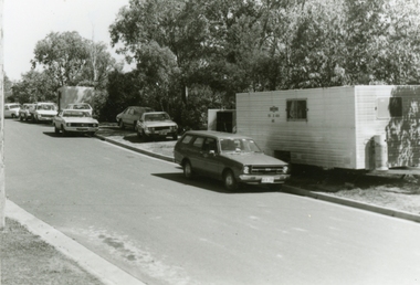
Part of a 43-photo record of the MMBW�s engineering feat in drilling a 12 inch pipe line up to 40 feet deep through rock hardened by volcanic action associated with geological fault that occurs along the line. The work took place from October 1979 to May 1980 on the southern boundary of Hubbard Reserve, North Ringwood. The collection was presented to the Ringwood Historical Research Group by J Clarke on 9th June 1980.E561 N5 Feb 1980 A43 Cars and caravans of the tunnelling gang in Burlock Ave -
 Ringwood and District Historical Society
Photographs, 1979-80 MMBW pipe line project at Hubbard Reserve, North Ringwood
Part of a 43-photo record of the MMBW engineering feat in drilling a 12 inch pipe line up to 40 feet deep through rock hardened by volcanic action associated with geological fault that occurs along the line. The work took place from October 1979 to May 1980 on the southern boundary of Hubbard Reserve, North Ringwood. The collection was presented to the Ringwood Historical Research Group by J Clarke on 9th June 1980."E565 N8 16 April 1980 A43 The pipe laying has been finished, now to cover it all in." -
 Ringwood and District Historical Society
Photographs, 1979-80 MMBW pipe line project at Hubbard Reserve, North Ringwood � hydraulic mole
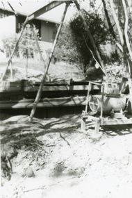
Part of a 43-photo record of the MMBW�s engineering feat in drilling a 12 inch pipe line up to 40 feet deep through rock hardened by volcanic action associated with geological fault that occurs along the line. The work took place from October 1979 to May 1980 on the southern boundary of Hubbard Reserve, North Ringwood. The collection was presented to the Ringwood Historical Research Group by J Clarke on 9th June 1980.E565 N10 28 April 1980 A43 The "muscles" of the mechanical mole, driven by a hydraulic line from a powerful "power pack". -
 Ringwood and District Historical Society
Photographs, 1979-80 MMBW pipe line project at Hubbard Reserve, North Ringwood � Line of tunnel shafts
Part of a 43-photo record of the MMBW�s engineering feat in drilling a 12 inch pipe line up to 40 feet deep through rock hardened by volcanic action associated with geological fault that occurs along the line. The work took place from October 1979 to May 1980 on the southern boundary of Hubbard Reserve, North Ringwood. The collection was presented to the Ringwood Historical Research Group by J Clarke on 9th June 1980.E561 N8 Feb 1980 A43 Line of tunnel shafts running from bottom centre to left of centre -
 Ringwood and District Historical Society
Photographs, 1979-80 MMBW pipe line project at Hubbard Reserve, North Ringwood � Tunnel shafts
Part of a 43-photo record of the MMBW�s engineering feat in drilling a 12 inch pipe line up to 40 feet deep through rock hardened by volcanic action associated with geological fault that occurs along the line. The work took place from October 1979 to May 1980 on the southern boundary of Hubbard Reserve, North Ringwood. The collection was presented to the Ringwood Historical Research Group by J Clarke on 9th June 1980.E561 N12 Feb 1980 A43 Line of tunnel shafts at 29-30 Burlock Avenue showing swivel cranes 5 and 6 from the bore-hole in Lot 7