Showing 2169 items matching "the 1920s"
-
 Sunshine and District Historical Society Incorporated
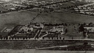
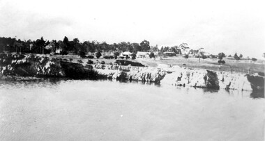
Photograph - Housing on Talmage Street in the 1920s, 1920s
... Housing on Talmage Street in the 1920s...Housing on Talmage Street in the 1920s...Photograph of 1920s Aerial view of homes along Talmage Street in foreground are the Bendigo rail lines and the track which services the Albion Flour Mill and the homesteads of Geo and HV McKays as well as Fergusons Left to top right is King Edwards Avenue On the top right to top left runs Sydney Street Top area is of soldiers settlements WWI...1920s...McKay Talmage Street Albion House Photograph of 1920s Aerial view of homes along Talmage Street in foreground are the Bendigo rail lines and the track which services the Albion Flour Mill and the homesteads of Geo and HV McKays as well as Fergusons Left to top right is King Edwards Avenue On the top right to top left runs Sydney Street Top area is of soldiers settlements WWI Housing on Talmage Street in the 1920s Photograph Housing on Talmage Street in the 1920s ...Photograph of 1920s Aerial view of homes along Talmage Street in foreground are the Bendigo rail lines and the track which services the Albion Flour Mill and the homesteads of Geo and HV McKays as well as Fergusons Left to top right is King Edwards Avenue On the top right to top left runs Sydney Street Top area is of soldiers settlements WWImckay, talmage street, albion, house -
 Canterbury History Group
Photograph - Photograph of the enamel picture plaque for Maling Road in the 1920s, Jan Pigot, 2004
... Photograph of the enamel picture plaque for Maling Road in the 1920s...Coloured photograph of the enamel picture plaque for Maling Road in the 1920s. There are 2 copies of this photograph in the pocket....Photograph Photograph of the enamel picture plaque for Maling Road in the 1920s Jan Pigot ...Coloured photograph of the enamel picture plaque for Maling Road in the 1920s. There are 2 copies of this photograph in the pocket.canterbury, maling road, shops, signs, plaques -
Canterbury History Group
Photograph - Photograph of the enamel picture plaque for Maling Road in the 1920s, Jan Pigot, 2004
... Photograph of the enamel picture plaque for Maling Road in the 1920s...Coloured photograph of the enamel picture plaque for Maling Road in the 1920s on the brick wall of 80 Maling Road, Canterbury...Canterbury Maling Road Shops Signs Plaques Coloured photograph of the enamel picture plaque for Maling Road in the 1920s on the brick wall of 80 Maling Road, Canterbury Photograph Photograph of the enamel picture plaque for Maling Road in the 1920s Jan Pigot ...Coloured photograph of the enamel picture plaque for Maling Road in the 1920s on the brick wall of 80 Maling Road, Canterburycanterbury, maling road, shops, signs, plaques -
Canterbury History Group
Photograph - Street view of the enamel picture plaque for Maling Road in the 1920s, Jan Pigot, 2004
... Street view of the enamel picture plaque for Maling Road in the 1920s...Coloured photograph of the enamel picture plaque for Maling Road in the 1920s on the red brick wall of No. 80 Maling Road, Canterbury...Canterbury Maling Road Shops Signs Plaques Coloured photograph of the enamel picture plaque for Maling Road in the 1920s on the red brick wall of No. 80 Maling Road, Canterbury Photograph Street view of the enamel picture plaque for Maling Road in the 1920s Jan Pigot ...Coloured photograph of the enamel picture plaque for Maling Road in the 1920s on the red brick wall of No. 80 Maling Road, Canterburycanterbury, maling road, shops, signs, plaques -
 Bendigo Historical Society Inc.
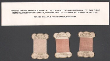
Ephemera - "Marvel Darner & Fancy Worker" cottons belonged to Ivy Kennedy, who was employed at Myer Melbourne in the 1920s
... "Marvel Darner & Fancy Worker" cottons belonged to Ivy Kennedy, who was employed at Myer Melbourne in the 1920s...."Marvel Darner & Fancy Worker" cottons belonged to Ivy Kennedy, who was employed at Myer Melbourne in the 1920s. The referenced "Marvel Darner" could not be located. ...Ephemera "Marvel Darner & Fancy Worker" cottons belonged to Ivy Kennedy, who was employed at Myer Melbourne in the 1920s. ...Myer advertising fan"Marvel Darner & Fancy Worker" cottons belonged to Ivy Kennedy, who was employed at Myer Melbourne in the 1920s. The referenced "Marvel Darner" could not be located. Three card silken lisle mercerised mending threads produced for Myer Emporium Ltd. Melbourne included. social history, myer business history -
 Kew Historical Society Inc
Photograph - Photographs [Series], Robert Baker, Display: Model Kitchen of the 1920s, Kew Library, 2014, 2014
... Display: Model Kitchen of the 1920s, Kew Library, 2014...australian dometsic architecture - kitchens - 1920s...One of two photographs of a display at the Kew Library, curated by Les Littlechild featuring items from the Kew Historical Society's and from private collections, of a model 1920s kitchen in Kew....Display: Model Kitchen of the 1920s, Kew Library, 2014 Photograph Photographs [Series] Robert Baker ...The Kew Historical Society, founded in 1958, is one of the oldest continuing historical societies in the Greater Melbourne region. From its beginnings, the Society has mounted exhibitions and/or displays, in early days in shop windows and in community spaces located in the Kew City Hall (later Kew Library), and since 2010 at the Kew Court House. Exhibitions typically coincided with the annual Kew Community Festival in March, but after 2013 evolved into three new exhibitions yearly at the Kew Court House. Smaller displays continue to be mounted in the Kew Library. One of two photographs of a display at the Kew Library, curated by Les Littlechild featuring items from the Kew Historical Society's and from private collections, of a model 1920s kitchen in Kew.kew historical society - exhibitions, australian dometsic architecture - kitchens - 1920s -
 Surrey Hills Historical Society Collection
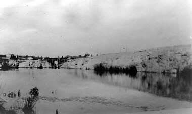
Photograph, Grovedale Road Quarry in the 1920s - looking south, c1920
... Grovedale Road Quarry in the 1920s - looking south...Black and white photo of the quarry between Grovedale Road and James Street taken in the 1920s and looking south. In the foreground is an area of water with reeds in the LH corner. ...Grovedale Road Quarry in the 1920s - looking south Photograph Photograph ...The quarry was part of John Butler Maling's property. He was one of the original settlers of the area and farmed the area between Weybridge Street and Whitehorse Road. Clay was quarried from part of this area and used to make the bricks used in the construction of his home, known as 'Ancyra'. This is still extant at the corner of Weybridge and James Streets. Maling grazed cows and used the quarry as a water source. He was the uncle of John Butler Maling, Mayor of Camberwell. He was married to Kate Conlon in 1882. They had 3 children: Silas Young, Alick and Zillah. Maling was born in c1829 in Shepreth, Cambridgeshire; he died in Surrey Hills on 9 October 1912 and is buried in Box Hill Cemetery - CE-*-0586. Mrs Kate Maling (born c1859 in Co Meath, Ireland) died at the property on 8 March 1921. She is buried in Brighton General Cemetery. Probate was valued at over 10,000 pounds and included other properties in Sandringham, Hawthorn and Macedon. At the time of her death the Surrey Hills property was described as being 23 acres with 2 brick houses, 1 cow, 2 heifers and 40 fowls or chickens. The property was subdivided after her death. The property was subdivided into 110 house blocks in c1923 - see Maling's Estate subdivision flyer on the State Library of Victoria's website. This shows that the Grovedale Park site had been acquired by Camberwell Council by this time. An attached newspaper clipping documents prices realised for a cross-section of blocks. The MMBW map of 1925, also on the SLV website, shows the outline of the clayhole / quarry. The quarry was filled in after several drownings or near drownings and the land is now occupied by a park and playground, known as Grovedale Road Park, maintained by the City of Boroondara. Beckett Park is sited on horizon to the left beyond the trees. This documents the landscape prior to close settlement and is material to early building and farming in the Surrey Hills area.Black and white photo of the quarry between Grovedale Road and James Street taken in the 1920s and looking south. In the foreground is an area of water with reeds in the LH corner. Beyond on the high banks there are single storey houses in the background and (?) some light poles. An object that looks like a tank on posts is in a cutting on the far bank.quarries, grovedale road, james street, clay quarries, farming, kate conlon, kate maling, john butler maling, ancyra -
 Surrey Hills Historical Society Collection
Photograph, Grovedale Road Quarry in the 1920s - looking north, c1920
... Grovedale Road Quarry in the 1920s - looking north...Black and white photo of the quarry between Grovedale Road and James Street taken in the 1920s and looking north. In the foreground is an area of water with high banks dividing the horizontal centre. ...Grovedale Road Quarry in the 1920s - looking north Photograph ...The quarry was part of John Butler Maling's property. He was one of the original settlers of the area and farmed the area between Weybridge Street and Whitehorse Road. Clay was quarried from part of this area and used to make the bricks used in the construction of his home, known as 'Ancyra'. This is still extant at the corner of Weybridge and James Streets. Maling grazed cows and used the quarry as a water source. He was the uncle of John Butler Maling, Mayor of Camberwell. He was married to Kate Conlon in 1882. They had 3 children: Silas Young, Alick and Zillah. Maling was born in c1829 in Shepreth, Cambridgeshire; he died in Surrey Hills on 9 October 1912 and is buried in Box Hill Cemetery - CE-*-0586. Mrs Kate Maling (born c1859 in Co Meath, Ireland) died at the property on 8 March 1921. She is buried in Brighton General Cemetery. Probate was valued at over 10,000 pounds and included other properties in Sandringham, Hawthorn and Macedon. At the time of her death the Surrey Hills property was described as being 23 cres with 2 brick houses, 1 cow, 2 heifers and 40 fowls or chickens. The property was subdivided after her death. The quarry was filled in after several drownings or near drownings and the land is now occupied by a park and playground maintained by the City of Boroondara. Beckett Park is sited on horizon to the left beyond the trees. This documents the landscape prior to close settlement and is material to early building and farming in the Surrey Hills area.Black and white photo of the quarry between Grovedale Road and James Street taken in the 1920s and looking north. In the foreground is an area of water with high banks dividing the horizontal centre. Beyond are paddocks and trees behind which is a row of at least 3 single-storey houses. Light poles can be seen along a distant street. There are many mature trees in the background. The houses and trees are positioned along Whitehorse Road in the vicinity of Westminster Street. Shadows indicate the photo was taken in early morning or evening.quarries, grovedale road, james street, surrey hills, balwyn, clay quarries, ancyra, kate conlon, kate maling, john butler maling, farming -
 Inverloch Historical Society
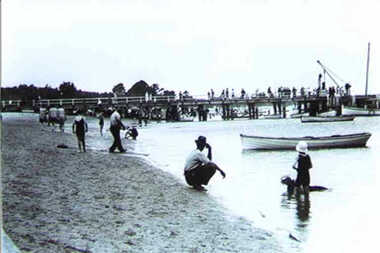
Photograph - Western side of Inverloch Pier from the 1920s with crane, boats and people enjoying the beach, 000514 - Photograph - 1920's Inverloch Pier
... Western side of Inverloch Pier from the 1920s with crane, boats and people enjoying the beach....Inverloch gippsland 000514 - Photograph - 1920's Inverloch Pier Photograph Western side of Inverloch Pier from the 1920s with crane, boats and people enjoying the beach. ... -
 Surrey Hills Historical Society Collection
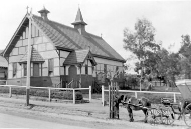
Photograph, Holy Trinity Church, Surrey Hills in the 1920s
... Holy Trinity Church, Surrey Hills in the 1920s...Norman Carter took many photos of Surrey Hills and Mont Albert from the 1920s in particular of events and activities associated with the Church of England....Holy Trinity Church, Surrey Hills in the 1920s Photograph Norman Carter ...This church was built in 1907 and became known as Holy Trinity Surrey Hills. This name had previously been used by the Anglican Church in Mont Albert Road, Mont Albert. This henceforth became known as St George's Anglican Church, Mont Albert. There are 2 copies: the original donated print and an enlargement. The original is mounted on card with photo mounts along with 890, 891 and 892. It measures 13 cm x 9 cm. Norman Carter took many photos of Surrey Hills and Mont Albert from the 1920s in particular of events and activities associated with the Church of England.Black and white photo of the original Holy Trinity Church building in Union Road. It is constructed of weatherboards, above which there is plasterboard and timber strapping. The roof is of terracotta tiles with a small steeple at the front and a larger one towards the rear of the building. There is a box bay window at the front and the entrance is from a porch on the southern side of the building. This is approached by stairs. Part of the vicarage can be seen on the northern high side of the church and to the south there is vacant land. The whole property sits behind a simple post and wire fence. There is a phaeton in the foreground beside a relatively newly planted street tree. The road has bluestone kerb and channelling.churches, holy trinity church, anglican church, horse-drawn vehicles, norman brodley carter, union road -
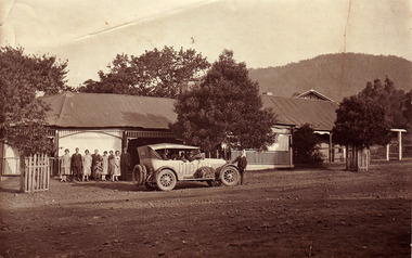
 Linton and District Historical Society Inc
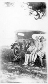
Photograph, Scotts Sturt St, Ballarat, At Devil's Kitchen, 1920s, probably the Whitehead family
... At Devil's Kitchen, 1920s, probably the Whitehead family..."Devils Kitchen 1920s"....At Devil's Kitchen, 1920s, probably the Whitehead family Photograph Scotts Sturt St, Ballarat ...Identified as most likely the Whitehead family, as the young man in the photograph bears a striking similarity to the young man identified as Alan Whitehead in the photo which is Registration no. 423.Sepia photograph of three women and two men seated on the running board of a early model car."Devils Kitchen 1920s".motor vehicles, devil's kitchen, piggoreet, whitehead family -
 Ringwood and District Historical Society
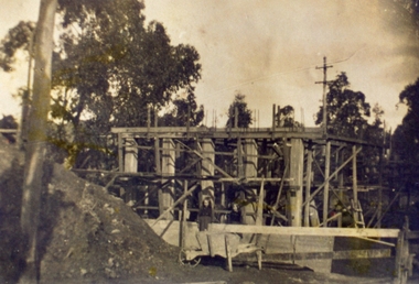
Photograph, Warrandyte Road Bridge over Mullum Mullum Creek, Ringwood with the higher bridge being erected. Date probably in the 1920s. Taken by M. McGivern
... Date probably in the 1920s. Taken by M. McGivern....Date probably in the 1920s. Taken by M. McGivern. Photograph ...Digital photograph -
 Surrey Hills Historical Society Collection
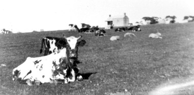
Photograph, Norman Carter, Part of Black's dairy farm in Mont Albert in the 1920s, 1920s
... Part of Black's dairy farm in Mont Albert in the 1920s...1920s...Part of Black's dairy farm in Mont Albert in the 1920s Photograph Photograph Norman Carter Ken Hall Norman Carter ...Photo is likely to have been taken pre-1924 when the land was subdivided. Donor information is that this was taken from a home in Churchill Street, Mont Albert; it would be looking south towards Mont Albert Road. Black's dairy farm occupied the area just east of Hamilton Street to near Elgar Road. It was subdivided into 88 house allotments along Churchill Street, Bruce Street, Black Street, Proudfoot Street and View Street. The solicitors were Proudfoot & Horton, 360 Collins Street; estate agents were Duncan & Weller, 29 Queen Street. The real estate subdivision notice on the SLV website states that Neil Black had been the owner for 50 years. To date no trace of a Neil Black has been found. Box Hill rate books simply give BLACK as the owner in 1877 (no first name); the entry for 1878-1884 states Robert Black. The 1909 electoral roll has entries for Mont Albert Road for Robert Black (farmer), Thomas Black (carter) & Elizabeth Black (HD). The 1912 electoral roll has entries for Mont Albert Road for Robert Black (farmer), Thomas Black (labourer), John Arthur Black (carter) & Elizabeth Black (HD). Robert Black died in 1920 (b. 1836) and is buried in Box Hill Cemetery (CE-*-0057). His parents were John and Margaret Black. He married Lizzie Foley in 1878. She was the daughter of Margaret & John Foley, born in 1859. She died in 1902 aged 43 years and is probably buried in the same grave, although the cemetery records record her age as 0 years. Children: 1. James Hughbert (1880-1954) 2. John Arthur (1881-1959) 3. Alice (1882-1883) - died aged 6 months 4. Laura Elizabeth (1883-1951) 5. Thomas (1885-1965) 6. Isabella (1887-1963) 7. Eleanor (1889-1963) 8. Ada Maud (1890-1968) 9. Robert (1892-1930). BDM Victoria states places of birth as Box Hill, Surrey Hills or Mont Albert. Many of the family are buried in Box Hill Cemetery. None of the girls appear to have married. Communication from a descendant of John Arthur Black gives the following: "John Arthur Black, son of Robert & Lizzie Foley, married Gladys Anne Layton had 4 children, Robert, Elenore, Marion (Follett) & Annie; they had farm on Stud Road, Dandenong where they milked 30 cows that he retired to after being a earth-moving contractor with draft horses and dug irrigation ditches around Shepparton." This is important as documentation of the area's early farming land use.Black and white photo of a paddock with cows and sheep grazing. On the horizon is a simple cottage with a small veranda and 2 chimneys and scattered trees.black's dairy farm, dairying, farms, churchill street, black street, proudfoot street, bruce street, view street, neil black, proudfoot & horton, duncan & weller, robert black, lizzie black, lizzie foley, james hubert black, john arthur black, alice black, laura elizabeth black, thomas black, isabella black, eleanor black, ada maud black, robert black jnr, box hill cemetery -
 Friends of Ballarat Botanical Gardens History Group
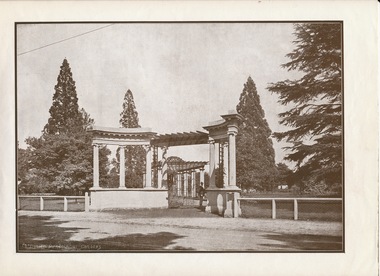
Photograph - Digital image - jpg, McDonald Gates in the 1920s
... McDonald Gates in the 1920s...Friends of Ballarat Botanical Gardens History Group George Longley Building Gillies Street North entrance Ballarat West 3350 Garden gates John Young McDonald Ballarat Botanical Gardens Black and white photograph McDonald Gates in the 1920s Photograph Digital image - jpg ...Black and white photographgarden gates, john young mcdonald, ballarat botanical gardens -
 Upper Yarra Museum
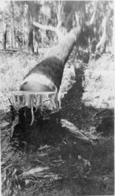
Negative Photographic Reproduction, The fallen tree Early 1920s Hoddles Creek
... The fallen tree Early 1920s Hoddles Creek ...fallen tree hoddles creek early 1920s...The fallen tree Early 1920s Hoddles Creek Negative Black white Scanned at 600 dpi....Upper Yarra Museum Old Railway Station 2415C Warburton Highway Yarra Junction yarra-valley-and-dandenong-ranges fallen tree hoddles creek early 1920s The fallen tree Early 1920s Hoddles Creek Negative Black white Scanned at 600 dpi. ...The fallen tree Early 1920s Hoddles Creek Negative Black white Scanned at 600 dpi.fallen tree hoddles creek early 1920s -
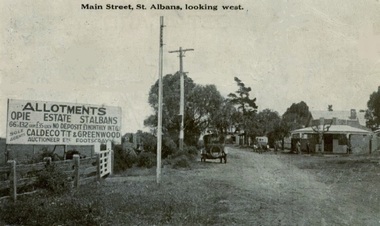 Sunshine and District Historical Society Incorporated
Photograph - St Albans looking west 1920s, 1925
... St Albans looking west 1920s...St Albans looking west 1920s...Card depicts a record of Main Street in St Albans looking west Cars indicate period of early 1920s...Albans Main Road West Card depicts a record of Main Street in St Albans looking west Cars indicate period of early 1920s St Albans looking west 1920s Photograph St Albans looking west 1920s ...Card depicts a record of Main Street in St Albans looking west Cars indicate period of early 1920sst. albans, main road west -
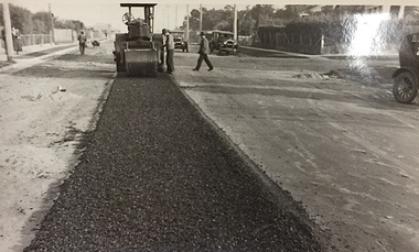 Kew Historical Society Inc
Photograph, City of Kew, Public Works, Road Construction, c.1920s
... It is believed that the photograph can be dated to the 1920s. ...Inscription on reverse: "Road making. (?1920s cars)"....c.1920s...It is believed that the photograph can be dated to the 1920s. Public Works, Road Construction Photograph Photograph City of Kew ...An original photograph donated to the Kew Historical Society by the City's Engineering Department before the amalgamation of Kew into the City of Boroondara in 1994.While not all of the photographs are of Studley Park, Kew or East Kew, each photo provides a fine snapshot of the work of local government engineering departments of the period. They reveal they types of labour conducted, the techniques used and the equipment and machinery in the possession of the local government authority. Public works. A photograph of a suburban street under construction using a steamroller. Neither the street nor the location has been identified. It is believed that the photograph can be dated to the 1920s. Inscription on reverse: "Road making. (?1920s cars)".steamroller, road construction building, city of kew, city of kew (engineering department) -
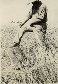 Sunshine and District Historical Society Incorporated
Photograph - AL Harvestor 1920s
... AL Harvestor 1920s...AL Harvestor 1920s...Two photos of an AL Harvester in a crop supposedly at Mount Misery in the early 1920s. Mr Jack Jackson and two other persons in one photo and Mr Jack Jackson on machinery in other photo Illustrates crop conditions and rock to be missed by machine...Farm Machinery Two photos of an AL Harvester in a crop supposedly at Mount Misery in the early 1920s. Mr Jack Jackson and two other persons in one photo and Mr Jack Jackson on machinery in other photo Illustrates crop conditions and rock to be missed by machine AL Harvestor 1920s Photograph AL Harvestor 1920s ...Two photos of an AL Harvester in a crop supposedly at Mount Misery in the early 1920s. Mr Jack Jackson and two other persons in one photo and Mr Jack Jackson on machinery in other photo Illustrates crop conditions and rock to be missed by machinefarm machinery -
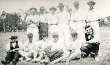 Ringwood and District Historical Society
Photograph, Heathmont Cricket Club in the early 1920s
... Heathmont Cricket Club in the early 1920s...Ringwood and District Historical Society 125A Warrandyte Road Ringwood North melbourne Heathmont Cricket Club in the early 1920s Photograph ... -
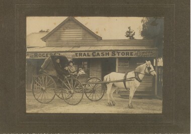 Rutherglen Historical Society
Photograph - Image, 1920s
... Photo taken in the early 1920s outside Roger's General Cash Store, Great Northern Township..."Early 1920s at Great Northern Township, via Rutherglen. ...1920s...Photo taken in the early 1920s outside Roger's General Cash Store, Great Northern Township Photograph Image ...Black and white photograph, mounted on cardboard, of a horse and cart with the family of the "Stewarts". Photo taken in the early 1920s outside Roger's General Cash Store, Great Northern Township"Early 1920s at Great Northern Township, via Rutherglen. L to R Fanny Stewart, Hector Stewart, Rae Stewart, Myra Stewart."stewart family, fanny stewart, hector stewart, rae stewart, myra stewart, rogers store, general cash store, great northern township -
 Marysville & District Historical Society
Photograph (item) - Black and white photographs, 1920s
... Two black and white photographs of cars travelling along the Black Spur in the 1920s....Two black and white photographs of cars travelling along the Black Spur in the 1920s....1920s...Two black and white photographs of cars travelling along the Black Spur in the 1920s. Two black and white photographs of cars travelling along the Black Spur in the 1920s. black spur transport vehicle car victoria australia Two black and white photographs of cars travelling along the Black Spur in the 1920s. ...Two black and white photographs of cars travelling along the Black Spur in the 1920s.Two black and white photographs of cars travelling along the Black Spur in the 1920s.black spur, transport, vehicle, car, victoria, australia -
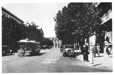 Melbourne Tram Museum
Photograph - Collins St - East end, 1920s
... Some soft-top motor vehicles are in view along with a postal pillar or letterbox. Photo 1920s...In Pencil "Top of Collins St 1920s, (Duplicate Ray Pearson)...1920s...Some soft-top motor vehicles are in view along with a postal pillar or letterbox. Photo 1920s Yields information about the east end of Collins St and cable trams. trams Collins St cable trams In Pencil "Top of Collins St 1920s, (Duplicate Ray Pearson) Black and white photograph, with source notes on the rear. ...The photograph shows the east end of Collins St with a cable tram set inbound towards Spencer St between Exhibition and Spring Streets. The State Treasury building is in the far background. Some soft-top motor vehicles are in view along with a postal pillar or letterbox. Photo 1920sYields information about the east end of Collins St and cable trams.Black and white photograph, with source notes on the rear.In Pencil "Top of Collins St 1920s, (Duplicate Ray Pearson)trams, collins st, cable trams -
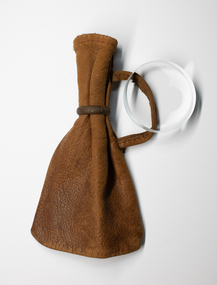 Charlton Golden Grains Museum Inc
Functional object - Leather Purse
... Purse used by gentlemen up to 1920s...Leather Sovereign purse carried by gentleman up to 1920s. To open - metal ring is slid over the top of the pouch...Purse used by gentlemen up to 1920s Sovereign Purse leather purse Frederick Edwards Leather Sovereign purse carried by gentleman up to 1920s. ...Purse used by gentlemen up to 1920sLeather Sovereign purse carried by gentleman up to 1920s. To open - metal ring is slid over the top of the pouchsovereign purse, leather purse, frederick edwards -
 Sunshine and District Historical Society Incorporated
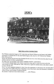
Essay - Albion State School 1920s The Willaton Connection
... Albion State School 1920s The Willaton Connection...Albion State School Albion Primary School Adelaide Street Albion John Willaton 5168.01 - Albion State School 1930s The Willaton Connection Page 1 5168.02 - Albion State School 1930s The Willaton Connection Page 2 5168.03 - Albion State School 1930s The Willaton Connection Page 3 Collection of Digital Photographs Essay Albion State School 1920s The Willaton Connection ...The current school, Albion Primary School, No 4265 opened in 1926. It was built on a site once owned by John Fitzgerald (1850s). The land was later acquired by H. V. McKay who had transferred his Sunshine Harvester Works to the area in 1905 - 7. In 1920, the Albion railway station was moved nearer Ballarat Road at the request of Mr McKay. More people came to live in the area including soldier settlers.Albion Primary School's mission is to 'Aim High' in all we do so that our students grow to be socially capable, reach their full academic potential and become caring, respectful community minded people. Albion Primary School is located in a residential area in Albion, a small pocket of the local government area of Brimbank, approximately 10 kilometres west of Melbourne and was established in 1926. Our current enrolment is 199 students. We have a rich cultural diversity amongst our school community. The school is set around a courtyard with spacious playing areas including a grassed oval, running track, games courts, an adventure playground, sand pit, jumping pits, shady courtyard and garden areas, a vegetable garden and fruit tree orchard. As well as classroom groups, we have our learning teams, student house groups (siblings are allocated to the same house) and a Junior School Council. The school has four main buildings. All classrooms have air conditioning and interactive screens. Block A houses classrooms, staff areas and the administration offices. Our newest building has classrooms and some small group/office spaces. Block B includes our library, canteen and a multi-purpose room used for indoor physical education, Perceptual Motor Program, drama, visiting performers, and community activities. Block C houses classrooms and specialist rooms. We expect and receive the best from our students in terms of their learning and behaviour. The school’s dedicated and effective staff is strongly committed to helping students achieve personal, behavioural, social and academic success. In terms of learning, the highest priority is placed on the work in English and Mathematics. We also have a range of specialist and extra-curricular programs that we provide. Our specialist teacher-librarian is involved in reading extension programs that support development in literacy. All children are able to develop their artistic abilities through visual arts and music program. Our music program is supported by the Australian Children's Music Foundation. A specialist Physical Education teacher provides lessons for all children as well as the opportunity for students to participate in organised lunch time sporting competitions between the house groups. Auslan is the additional language all students learn at Albion. All children participate in a student wellbeing program that focuses on developing strong connections and a sense of belonging within the school. Our school student leaders participate in programs that help develop their leadership skills. 5168.01 - Albion State School 1930s The Willaton Connection Page 1 5168.02 - Albion State School 1930s The Willaton Connection Page 2 5168.03 - Albion State School 1930s The Willaton Connection Page 3albion state school, albion primary school, adelaide street, albion, john willaton -
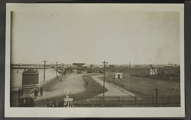 Mission to Seafarers Victoria
Photograph - Photograph, Sepia
... Found in photo album along with other pictures from the 1920s. Beware of trais...Medium-sized monochrome (sepia) photograph dating from the mid 1920s, depicting dockland scene.on page 11...Mission to Seafarers Victoria 717 Flinders Street Docklands melbourne Found in photo album along with other pictures from the 1920s. Beware of trais docks docklands fan album trains Medium-sized monochrome (sepia) photograph dating from the mid 1920s, depicting dockland scene.on page 11 Photograph Photograph, Sepia ...Found in photo album along with other pictures from the 1920s. Beware of traisMedium-sized monochrome (sepia) photograph dating from the mid 1920s, depicting dockland scene.on page 11docks, docklands, fan album, trains -
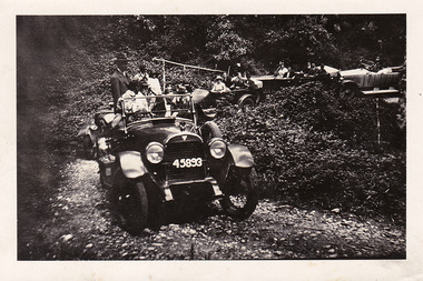
 Marysville & District Historical Society
Photograph (item) - Black and white photograph, 1920s
... The original photograph was taken in the 1920s....The original photograph was taken in the 1920s....1920s...The original photograph was taken in the 1920s. Photograph Black and white photograph ...A copy of a black and white photograph taken at The Falls guest house in Marysville. The original photograph was taken in the 1920s.A copy of a black and white photograph taken at The Falls guest house in Marysville. The original photograph was taken in the 1920s.marysville, victoria, australia, the falls, the marysville hotel, john hall, mrs sheahan, harry oxlee, annie oxlee, photograph -
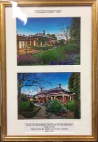 Kew Historical Society Inc
Photograph - Framed Photographs, John & Mary Curtin, 74 Charles Street, Kew, c. 2016
... Two colour photographs, mounted in a single gilt frame of the exterior of 74 Charles Street, Kew. During the 1920s, the house was the home of [Sir] Robert and [Dame] Pattie Menzies. ...The annotations to the photographs read: "74 Charles Street Kew / Home of Sir Robert and Dame Pattie Menzies / Early 1920s / Presented by John and Mary Curtin / May 2016"....Two colour photographs, mounted in a single gilt frame of the exterior of 74 Charles Street, Kew. During the 1920s, the house was the home of [Sir] Robert and [Dame] Pattie Menzies. ...Sir Robert Menzies and his family lived in a number of houses in Kew. He was the local MHR for Kew and for many years Prime Minister of AustraliaTwo colour photographs, mounted in a single gilt frame of the exterior of 74 Charles Street, Kew. During the 1920s, the house was the home of [Sir] Robert and [Dame] Pattie Menzies. The framed photographs were donated by subsequent owners of the property.The annotations to the photographs read: "74 Charles Street Kew / Home of Sir Robert and Dame Pattie Menzies / Early 1920s / Presented by John and Mary Curtin / May 2016".sir robert menzies, dame pattie menzies, 74 charles street (kew) -
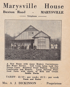 Marysville & District Historical Society
Ephemera (Item) - Accommodation booklet advertisement, Marysville House, Unknown
... Marysville House was built in the late 1920s by Arthur Dickinson....Marysville House was built in the late 1920s by Arthur Dickinson....Marysville House was built in the late 1920s by Arthur Dickinson. A digital copy of an advertisement for Marysville House near Marysville. ...A digital copy of an advertisement for Marysville House near Marysville. Marysville House was built in the late 1920s by Arthur Dickinson.A digital copy of an advertisement for Marysville House near Marysville. Marysville House was built in the late 1920s by Arthur Dickinson.marysville, victoria, australia, marysville house, arthur james dickinson, grace dickinson, arnold spooner, eileen marie spooner, eileen marie dickinson, grace sweetland, eric dowdle, elsie may denton, elsie may dickinson, peter dickinson, linda dickinson, 2009 black saturday bushfires, advertisement -
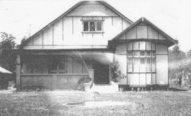 Marysville & District Historical Society
Photograph (Item) - Black and white photograph, Unknown
... Marysville House was build in the late 1920s by Arthur Dickinson....Marysville House was build in the late 1920s by Arthur Dickinson....Marysville House was build in the late 1920s by Arthur Dickinson. Photograph Black and white photograph ...A digital copy of a black and white photograph of Marysville House. Marysville House was build in the late 1920s by Arthur Dickinson.A digital copy of a black and white photograph of Marysville House. Marysville House was build in the late 1920s by Arthur Dickinson.marysville, victoria, australia, marysville house, arthur james dickinson, grace dickinson, arnold spooner, eileen marie spooner, eileen marie dickinson, grace sweetland, eric dowdle, elsie may denton, elsie may dickinson, peter dickinson, linda dickinson, 2009 black saturday bushfires, photograph -
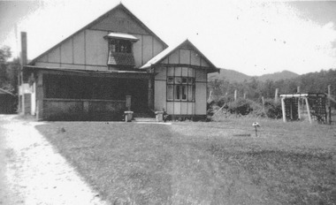 Marysville & District Historical Society
Photograph (Item) - Black and white photograph, Unknown
... Marysville House was build in the late 1920s by Arthur Dickinson....Marysville House was build in the late 1920s by Arthur Dickinson....Marysville House was build in the late 1920s by Arthur Dickinson. Photograph Black and white photograph ...A digital copy of a black and white photograph of Marysville House. Marysville House was build in the late 1920s by Arthur Dickinson.A digital copy of a black and white photograph of Marysville House. Marysville House was build in the late 1920s by Arthur Dickinson.marysville, victoria, australia, marysville house, arthur james dickinson, grace dickinson, arnold spooner, eileen marie spooner, eileen marie dickinson, grace sweetland, eric dowdle, elsie may denton, elsie may dickinson, peter dickinson, linda dickinson, 2009 black saturday bushfires, photograph