Showing 2 items matching "the paul hamlyn group"
-
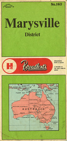 Marysville & District Historical Society
Ephemera (Item) - Tourist map, The Paul Hamlyn Group, Marysville District No. 163, 1950s
... ...the paul hamlyn group...Gives details of addresses in New South Wales and Victoria for The Paul Hamlyn Group....A tourist map of Marysville and the district which was produced by Broadbent's, a division of The Paul Hamlyn Group....The Paul Hamlyn Group...Gives details of addresses in New South Wales and Victoria for The Paul Hamlyn Group. A tourist map of Marysville and the district which was produced by Broadbent's, a division of The Paul Hamlyn Group. marysville victoria maps broadbent's the paul hamlyn group A tourist map of Marysville and the district which was produced by Broadbent's, a division of The Paul Hamlyn Group. ...A tourist map of Marysville and the district which was produced by Broadbent's, a division of The Paul Hamlyn Group. Drawn map of Marysville and the district. Has a legend, scale and a town map of Marysville. Has an index of locations and their grid details. Gives details of addresses in New South Wales and Victoria for The Paul Hamlyn Group.A tourist map of Marysville and the district which was produced by Broadbent's, a division of The Paul Hamlyn Group.marysville, victoria, maps, broadbent's, the paul hamlyn group -
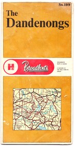 Emerald Museum & Nobelius Heritage Park
Map - Map of the Dandenongs, The Paul Hamlyn Group, c. 1970s
... On front: ' No. 199 / The / Dandenongs / Broadbents / Broadbents / Maps & Guides / A DIVISION OF / THE PAUL HAMLYN / GROUP'...The Paul Hamlyn Group...Map Map of the Dandenongs The Paul Hamlyn Group ...George Broadbent was a Geelong-born cyclist record-holder, who produced from 1896 the most comprehensive and detailed maps of Victoria until his death in October 1947. His son had taken over map production in 1945. This map of the Dandenongs c 1970s details tourist sites and walking tracks. This map shows streets and walking tracks and tourist sites significant in the Dandenongs c. 1970s.Front of fold-out map titled 'The Dandenongs No. 199', produced by Broadbents. Folded out, one side is a street map of the Dandenongs. The other side includes a street index, a list of tourist sites, a list of walking tracks, a map of Sherbrooke Forest, and a map of key approaches from the city to the Dandenongs.On front: ' No. 199 / The / Dandenongs / Broadbents / Broadbents / Maps & Guides / A DIVISION OF / THE PAUL HAMLYN / GROUP'broadbents, dandenongs, 1970s, tourist sites, walking tracks