Showing 174 items matching "the two paths"
-
 Flagstaff Hill Maritime Museum and Village
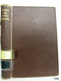
Book, The Two Paths
... The Two Paths......The Two Paths...The Two Paths Author: John Ruskin Publisher: George Allen Date: 1887...Warrnambool Shipwrecked-coast Flagstaff-Hill Flagstaff-Hill-Maritime-Museum Maritime-Museum Shipwreck-coast Flagstaff-Hill-Maritime-Village Shipwrecked-artefact Book Warrnambool Mechanics’ Institute Pattison Collection Warrnambool Library Ralph Eric Pattison Warrnambool City Librarian Mechanics’ Institute Library Victorian Library Board Warrnambool books and records Warrnambool Children’s Library The Two Paths John Ruskin Label on spine with typed text PAT 701 RUS The Two Paths Author: John Ruskin Publisher: George Allen Date: 1887 The Two Paths Book ...This item is from the ‘Pattison Collection’, a collection of books and records that was originally owned by the Warrnambool Mechanics’ Institute, which was founded in Warrnambool in 1853. By 1886 the Warrnambool Mechanics’ Institute (WMI) had grown to have a Library, Museum and Fine Arts Gallery, with a collection of “… choice productions of art, and valuable specimens in almost every branch and many wonderful national curiosities are now to be seen there, including historic relics of the town and district.” It later included a School of Design. Although it was very well patronised, the lack of financial support led the WMI in 1911 to ask the City Council to take it over. In 1935 Ralph Pattison was appointed as City Librarian to establish and organise the Warrnambool Library as it was then called. When the WMI building was pulled down in 1963 a new civic building was erected on the site and the new Warrnambool Library, on behalf of the City Council, took over all the holdings of the WMI. At this time some of the items were separated and identified as the ‘Pattison Collection’, named after Ralph Pattison. Eventually the components of the WMI were distributed from the Warrnambool Library to various places, including the Art Gallery, Historical Society and Flagstaff Hill. Later some were even distributed to other regional branches of Corangamite Regional Library and passed to and fro. It is difficult now to trace just where all of the items have ended up. The books at Flagstaff Hill Maritime Village generally display stamps and markings from Pattison as well as a variety of other institutions including the Mechanics’ Institute itself. RALPH ERIC PATTISON Ralph Eric Pattison was born in Rockhampton, Queensland, in 1891. He married Maude Swan from Warrnambool in 1920 and they set up home in Warrnambool. In 1935 Pattison accepted a position as City Librarian for the Warrnambool City Council. His huge challenge was to make a functional library within two rooms of the Mechanics’ Institute. He tirelessly cleaned, cleared and sorted a disarrayed collection of old books, jars of preserved specimens and other items reserved for exhibition in the city’s museum. He developed and updated the library with a wide variety of books for all tastes, including reference books for students; a difficult task to fulfil during the years following the Depression. He converted all of the lower area of the building into a library, reference room and reading room for members and the public. The books were sorted and stored using a cataloguing and card index system that he had developed himself. He also prepared the upper floor of the building and established the Art Gallery and later the Museum, a place to exhibit the many old relics that had been stored for years for this purpose. One of the treasures he found was a beautiful ancient clock, which he repaired, restored and enjoyed using in his office during the years of his service there. Ralph Pattison was described as “a meticulous gentleman whose punctuality, floorless courtesy and distinctive neat dress were hallmarks of his character, and ‘his’ clock controlled his daily routine, and his opening and closing of the library’s large heavy doors to the minute.” Pattison took leave during 1942 to 1942 to serve in the Royal Australian Navy, Volunteer Reserve as Lieutenant. A few years later he converted one of the Museum’s rooms into a Children’s Library, stocking it with suitable books for the younger generation. This was an instant success. In the 1950’s he had the honour of being appointed to the Victorian Library Board and received more inspiration from the monthly conferences in Melbourne. He was sadly retired in 1959 after over 23 years of service, due to the fact that he had gone over the working age of council officers. However he continued to take a very keen interest in the continual development of the Library until his death in 1969. The Pattison Collection, along with other items at Flagstaff Hill Maritime Village, was originally part of the Warrnambool Mechanics' Institute’s collection. The Warrnambool Mechanics’ Institute Collection is primarily significant in its totality, rather than for the individual objects it contains. Its contents are highly representative of the development of Mechanics' Institute libraries across Australia, particularly Victoria. A diversity of publications and themes has been amassed, and these provide clues to our understanding of the nature of and changes in the reading habits of Victorians from the 1850s to the middle of the 20th century. The collection also highlights the Warrnambool community’s commitment to the Mechanics’ Institute, reading, literacy and learning in the regions, and proves that access to knowledge was not impeded by distance. These items help to provide a more complete picture of our community’s ideals and aspirations. The Warrnambool Mechanics Institute book collection has historical and social significance for its strong association with the Mechanics Institute movement and the important role it played in the intellectual, cultural and social development of people throughout the latter part of the nineteenth century and the early twentieth century. The collection of books is a rare example of an early lending library and its significance is enhanced by the survival of an original collection of many volumes. The Warrnambool Mechanics' Institute’s publication collection is of both local and state significance. The Two Paths Author: John Ruskin Publisher: George Allen Date: 1887Label on spine with typed text PAT 701 RUS warrnambool, shipwrecked-coast, flagstaff-hill, flagstaff-hill-maritime-museum, maritime-museum, shipwreck-coast, flagstaff-hill-maritime-village, shipwrecked-artefact, book, warrnambool mechanics’ institute, pattison collection, warrnambool library, ralph eric pattison, warrnambool city librarian, mechanics’ institute library, victorian library board, warrnambool books and records, warrnambool children’s library, the two paths, john ruskin -
 Mrs Aeneas Gunn Memorial Library
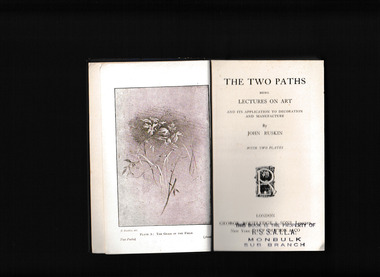
Book, George Routledge, The two paths : being lectures on art and its application to decoration and manufacture, delivered in 1858-9, 19
... The two paths : being lectures on art and its application to decoration and manufacture, delivered in 1858-9...Ill, p.232. The two paths : being lectures on art and its application to decoration and manufacture, delivered in 1858-9 Book George Routledge John Ruskin ...The following addresses, though spoken at different times, are intentionally connected in subject; their aim being to set one or two main principles of art in simple light before the general student, and to indicate their practical bearing on modern design. The law which it has been my effort chiefly to illustrate is the dependence of all noble design, in any kind, on the sculpture or painting of Organic Form.Ill, p.232.non-fictionThe following addresses, though spoken at different times, are intentionally connected in subject; their aim being to set one or two main principles of art in simple light before the general student, and to indicate their practical bearing on modern design. The law which it has been my effort chiefly to illustrate is the dependence of all noble design, in any kind, on the sculpture or painting of Organic Form. art, design -
 Whitehorse Historical Society Inc.
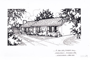
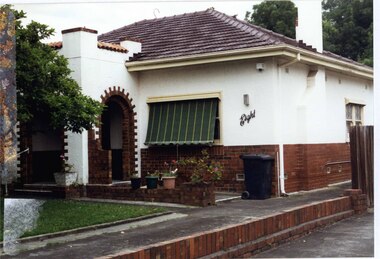
Artwork, other - Ink Line Drawing, Margaret Picken, 4 Yea Crt., Forest Hill, 1994
... A black ink line drawing on drafters film by Margaret Picken, of 4 Yea Crt., Forest Hill depicting a brick single story house, with a driveway on the left leading to separate garage. off of the driveway are two paths, one past the front of the house and one up to the front door. ...Whitehorse Historical Society Schwerkolt Cottage Housing Architecture Margaret Picken House Garden Forest Hill Real Estate 4 Yea Crt., Forest Hill Margaret Picken '94 Woodards - BoxHill A black ink line drawing on drafters film by Margaret Picken, of 4 Yea Crt., Forest Hill depicting a brick single story house, with a driveway on the left leading to separate garage. off of the driveway are two paths, one past the front of the house and one up to the front door. ...A property illustration by Margaret Picken Commissioned by the real estate agency Woodards Boxhill for the purpose of advertising 4 Yea Crt., Forest Hill. This property has be listed as having sold for $120,000 in 1994. Made by using Rotring ‘Rapidigraph’ drafting pens with Rotring ink on Rapidigraph polyester drafting film, double matte. Trained as a cartographic draftsman within the mining industry, Margaret Picken is an artist who worked producing property illustrations for real estate agencies in eastern suburbs of Victoria from 1983-2005. Retiring from the industry as technological changes favored coloured photography over illustrations, and commissioning companies over sole contractors.This artwork is of Historical Significance as a record of local domestic architecture.A black ink line drawing on drafters film by Margaret Picken, of 4 Yea Crt., Forest Hill depicting a brick single story house, with a driveway on the left leading to separate garage. off of the driveway are two paths, one past the front of the house and one up to the front door. There are two hole punch holes near the centre of the upper edge4 Yea Crt., Forest Hill Margaret Picken '94 Woodards - BoxHillwhitehorse historical society, schwerkolt cottage, housing, architecture, margaret picken, house, garden, forest hill, real estate -
 Darebin Parklands Association
Entrance to Rockbeare Park 15th February 1976, Rockbeare Park Conservation Group, 1976
... He designed a winding path but Council insisted on two straight paths for vehicle access....He designed a winding path but Council insisted on two straight paths for vehicle access. ...Ellis Stones, well known landscape designer, designed and supervised the entrance to the Parklands from Rockbeare Grove. He designed a winding path but Council insisted on two straight paths for vehicle access.B&W photograph. Annotated with:[RPCG working bee]. Shows children Phil and Gill Course. This item and all other Darebin Parklands Association archival material is now held by State Library Victoria (Accession No: YMS 13746). Please contact State Library Victoria if access is required. -
 Anglesea and District Historical Society
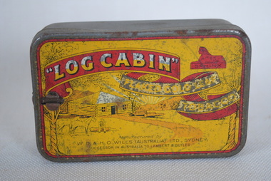
Tin, 1913
... Showers picture of house, path, two horses and a man sitting on a log with mountains and trees in background....Showers picture of house, path, two horses and a man sitting on a log with mountains and trees in background. ...Small tobacco tin. Yellow with red banner. Showers picture of house, path, two horses and a man sitting on a log with mountains and trees in background.FLAKED GOLD LEAF "Log Cabin" W.D. & H.O. WILLS (AUSTRALIA) LTD. SYDNEY SUCCESSOR IN AUSTRALIA TO LAMBERT & BUTLER. On side: FINE 2oz net weight when packed. Upper right corner: Red Sphinxlog cabin, tobacco, smoking -
 Eltham District Historical Society Inc
Photograph, Main Road, Research
... Three colour photographs of Main Road between Research and Eltham East; two showing the bike path looking tworads Eltham and one viewed from Warrandyte Road near the roundabout...Eltham District Historical Society Inc 728 Main Rd Eltham melbourne eltham east research main road research warrandyte road warrandyte road paths bike paths Three colour photographs of Main Road between Research and Eltham East; two showing the bike path looking tworads Eltham and one viewed from Warrandyte Road near the roundabout Main Road, Research Photograph ...Three colour photographs of Main Road between Research and Eltham East; two showing the bike path looking tworads Eltham and one viewed from Warrandyte Road near the roundabouteltham east, research, main road, research warrandyte road, warrandyte road, paths, bike paths -
 Clunes Museum
Photograph, QUEENS PARK
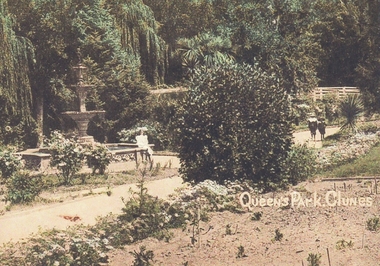
... COPIES OF PHOTOGRAPHS OF QUEEN'S PARK FOUNTAIN WITH A LADY SITTING ON THE FOUNTAIN EDGE FOUNTAIN AND TWO CHILDREN WALKING THE PATH 2. PHOTO OF THREE LADIES WALKING THROUGH QUEEN'S PARK....COPIES OF PHOTOGRAPHS OF QUEEN'S PARK FOUNTAIN WITH A LADY SITTING ON THE FOUNTAIN EDGE FOUNTAIN AND TWO CHILDREN WALKING THE PATH 2. PHOTO OF THREE LADIES WALKING THROUGH QUEEN'S PARK. ...1. COPIES OF PHOTOGRAPHS OF QUEEN'S PARK FOUNTAIN WITH A LADY SITTING ON THE FOUNTAIN EDGE FOUNTAIN AND TWO CHILDREN WALKING THE PATH 2. PHOTO OF THREE LADIES WALKING THROUGH QUEEN'S PARK.QUEEN'S PARK CLUNESlocal history, queen's park garden -
 Bendigo Historical Society Inc.
Postcard - POSTCARD.OVAL FRAMED LANDSCAPE.BIRTHDAY GREETINGS
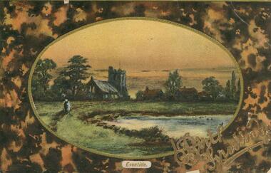
... Birthday wishes. Two people walking a path to the left. Pond or dam to centre left. ...Birthday wishes. Two people walking a path to the left. Pond or dam to centre left. ...Postcard. Oval framed landscape with church to the left and other housing off centre right, Eventid. Birthday wishes. Two people walking a path to the left. Pond or dam to centre left. Rear. Names deleted. -
 Whitehorse Historical Society Inc.
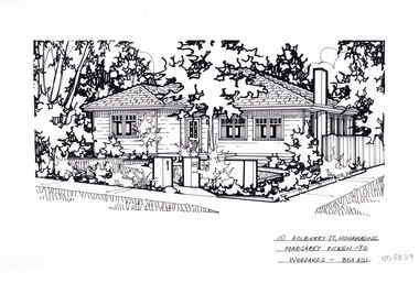
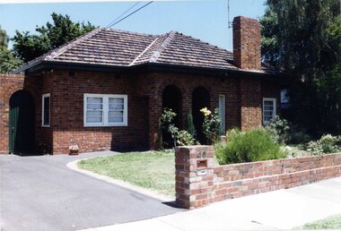
Artwork, other - Ink Line Drawing, Margaret Picken, 10 Holberry St., Nunawading, 1992
... At the start of the path are two pillars, one serving as a letterbox. ...At the start of the path are two pillars, one serving as a letterbox. ...A property illustration by Margaret Picken Commissioned by a real estate agency for the purpose of advertising 10 Holberry St., Nunawading. This property is listed as having sold for $139,000 in 1992 Made by using Rotring ‘Rapidigraph’ drafting pens with Rotring ink on Rapidigraph polyester drafting film, double matte. Trained as a cartographic draftsman within the mining industry, Margaret Picken is an artist who worked producing property illustrations for real estate agencies in eastern suburbs of Victoria from 1983-2005. Retiring from the industry as technological changes favored coloured photography over illustrations, and commissioning companies over sole contractors.This artwork is of Historical Significance as a record of local domestic architecture.A black ink line drawing on drafters film by Margaret Picken, of a black and white line drawing of a right hand side corner block single story weatherboard house with a footpath from the corner leading to the front door. At the start of the path are two pillars, one serving as a letterbox. The front yard is edged with garden beds. There are two hole punch holes on just under the upper edge.10 Holberry St., Nunawading Margaret Picken - 92 Woodards - Boxhillwhitehorse historical society, schwerkolt cottage, housing, architecture, margaret picken, house, garden, real estate, nunawading -
 Ballarat Tramway Museum
Drawing, C. Cosgrove, "Simplified Plan & Connections from Trolley to Controller, motors and to Earth", May. 1910
... Drawing titled - "Simplified Plan & Connections from Trolley to Controller, motors and to Earth" Shows trolley pole, switches, controller handle and electrical paths. Has two pencil notations - No. 2 end canopy switch and note on the earth return through axles etc. ...Drawing titled - "Simplified Plan & Connections from Trolley to Controller, motors and to Earth" Shows trolley pole, switches, controller handle and electrical paths. Has two pencil notations - No. 2 end canopy switch and note on the earth return through axles etc. ...Drawing prepared by C. Cosgrove, Superintendent May 1910 for the Electric Supply Co of Victoria Limited - Tramways showing the electrical connections for the control circuits for both power and braking notches for an electric tram. Controller has 5 series steps, 3 parallel steps and 7 braking steps. Drawing titled - "Simplified Plan & Connections from Trolley to Controller, motors and to Earth" Shows trolley pole, switches, controller handle and electrical paths. Has two pencil notations - No. 2 end canopy switch and note on the earth return through axles etc. Drawing has darkened with age. Possibly used for training itself.Yields information about the controllers ESCo was using at the time of the drawing, possibly used for training purposes. Has a strong association the person who prepared the drawing.Drawing has been prepared by hand on a sheet or paper and adhered to a very heavy cardboard, or has been prepared on the cardboard itself.Two pencil notations - as above.esco, controllers, training -
 Royal District Nursing Service (now known as Bolton Clarke)
Photograph - Digital image, c.1935
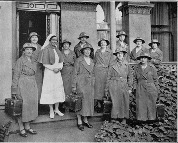
... They are standing in two rows, with some on the veranda of the building and some in front on the path; two Sisters are just off the path amid the shrubs. ...They are standing in two rows, with some on the veranda of the building and some in front on the path; two Sisters are just off the path amid the shrubs. ...Matron F. L. Gordon and the Sisters are standing in front of the Melbourne District Nursing Society (MDNS) Nurses Home at 39 Victoria Parade, Collingwood. The Nurses lived in this residence from 1914-1953. In 1926 the After-Care Home was built next door. This image was taken twelve months after the name of the Society changed from 'Melbourne District Nursing Society After Care 'Home' to 'Hospital'. The photograph shows the uniform of the District Division of the Melbourne District Nursing Society in the 1930s, with the uniform dress made of grey cotton. Their brimmed hat was made of felt with a cotton hat band with a red Maltese cross in the centre front. From its founding in 1885 until 1891 the Trained nurses, called 'Nurse' in those days, of the Melbourne District Nursing Society (MDNS) worked from their own homes which were located in the vicinity of their areas (districts). In November 1891 MDNS was able to rent a two story terraced house at 66 Cardigan Street, Carlton, at £65 a year, which contained accommodation for three Nurses and one pupil nurse as well as being used as their Headquarters. They left from their Nurses Home each morning and returned at the end of their shift to write up their book work before retiring for the day. Three years later, in 1894, they moved into a larger terraced house at 49 Drummond Street Carlton which was rented at ‘a very moderate rental’. There was a Board room, apartments for the Nurses and pupil nurse, a large dispensary which patients could attend each evening to have prescriptions signed and bottles refilled with ‘homely remedies’ and elixirs, which were administered for e.g. Consumptive cases. Doctor’s prescriptions were filled at the Pharmacy. Cupboards containing donated blankets and bedclothes for needy patients were kept in this room, and it was here where the Nurses kept their nursing bags which were refilled at the end of each shift ready for any emergency and for the next day. A list of Doctors the Nurses could call was kept by the telephone. The Home also had a kitchen where nourishing soup was made and distributed twice a week to the needy. Milk was also distributed when needed. In 1902 they moved into rented premises at 188 Leicester Street, Carlton and two years later, in 1904, to premises at 5 Royal Terrace, Nicholson Street, Fitzroy. They remained there for ten years and an Auction of furniture was held before their next move giving an idea of some of the contents: - Carpets, linoleum, walnut and oak sideboards, dining tables, walnut dining suite, Vienna chairs, walnut bedroom suite, cedar wardrobes, chests of drawers, duchess chests, bedsteads and bedding and general furnishings were for sale. In June 1914 at last the Society had sufficient funding to purchase their own terraced premises, ‘Floraston’ 39 Victoria Parade, Collingwood which became their Headquarters and Nurses Home. In 1926 the After-Care Home for recovering patients, (later called After-Care Hospital) was built by the Society next door, running from 41-47 Victoria Parade (became No. 45); the District Sisters continued to live at No. 39. In November 1953 the District Nursing Division moved into their new Headquarters and Nurses Home at 452 St. Kilda Road, Melbourne, with a change of name to Melbourne District Nursing Service in 1957. With Royal patronage, this changed to Royal District Nursing Service (RDNS) in 1966. As District expanded, and now with outlying districts to service and with a full fleet of District cars, Sisters lived in their own homes and visited their District Centre each morning to collect their work for the day and returned there at the end of their days work in the community to carry out their administrative work. The digital image shows Matron, Miss F.L. Gordon, wearing a white uniform and veil and a dark coloured cape standing amid a group of eleven District Trained nurses (Sisters), from the Melbourne District Nursing Society (MDNS). Two Sisters are to her left and the others to her right. They are standing in front of a grey building. The Sisters are wearing their uniforms of grey long coats with lapels; the coat is secured with a belt around the waist. This is worn over their grey uniforms, with white collars. Each Sister is wearing their uniform grey brimmed hat with a Maltese cross attached to the light hatband, and are carrying a square shaped nursing case. They are standing in two rows, with some on the veranda of the building and some in front on the path; two Sisters are just off the path amid the shrubs. Part of the grey concrete building can be seen behind the Sisters with the open door to the left and part of three long windows seen to its right. One Sister has her lower left arm resting on the veranda rail.'Miss F.L. Gordon, Matron, and some of the District Sisters'mdns, melbourne district nursing society, 39 victoria parade, collingwood, rdns, royal district nursing service, nurses home, miss f.l. gordon, mdns uniforms, mdns matron -
 Bendigo Military Museum
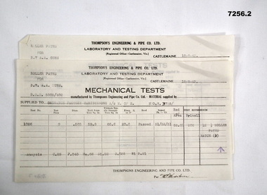
Document - MECHANICAL TEST RESULTS, Thompson's Engineering and Pipe Works, 1943
... Two sheets of paper from Thompson Engineering & Pipe Co. Ltd. To Ordnance Factory Maribyrnong Dated 18/8/43. Signed off by (??) Martin. 1. Results for tests on roller paths...Two sheets of paper from Thompson Engineering & Pipe Co. Ltd. To Ordnance Factory Maribyrnong Dated 18/8/43. Signed off by (??) Martin. 1. Results for tests on roller paths ...By referring to Cat No 7237.2 will bring up all items associated with Thompsons. Two sheets of paper from Thompson Engineering & Pipe Co. Ltd. To Ordnance Factory Maribyrnong Dated 18/8/43. Signed off by (??) Martin. 1. Results for tests on roller paths for 3.7 AA Guns (Batch 15). 2. Results for tests on roller paths for 3.7AA guns (Batch 9). Signed off by (??) Martin.3.7"aa guns, ord factory maribyrnong, thompsons castlemaine -
 Bendigo Military Museum
Map - RASvy " Map Makers Exhibition 2025 "- Map display, RAN Hydrographic Office, 1972 - 1992
... The shortest distance between two points on the earth's surface is called a "Great Circle Route" which is a route on a circular path on the surface of the earth where the centre of that circle is also the centre of the earth. ...The shortest distance between two points on the earth's surface is called a "Great Circle Route" which is a route on a circular path on the surface of the earth where the centre of that circle is also the centre of the earth. ...All of these Charts / Maps were used for the RSL Museum display " The Mapmakers " ( of RASvy. ) 10 Jun - 10 Aug 2025. .1 Catalogue of Tactical Pilotage Charts, 1:500 000 Scale. Digital Data Base available as at 30Jun 92. This catalogue page shows the extent of the Australian area of responsibility for aeronautical charting. .2 RAAF PLOTTING CHART. NP 22-2 (Navigational Plotting) Tasmania. MERCATOR PROJECTION. This series of charts were used for the training of RAAF Navigators. These charts were produced and printed at the Army Survey Regiment, Bendigo. .3 RAAF PLOTTING CHART AUSTRALIA - SOUTHEAST. NP 27 is Based on LAMBERT CONFORMAL CONIC PROJECTION. This series of charts was used by RAAF Navigators for the planning of RAAF flights. These charts were produced and printed at the Army Survey Regiment, Bendigo. .4 RAAF LONG RANGE PLOTTING CHART. NP 43-4 AUSTRALIA WESTERN. MERCATOR PROJECTION. This series of maps were used for the planning of RAAF flights. Of Particular note these charts were used to plot "Rhumb Lines or loxodromes" where a course crosses all Meridians (Lines of latitude and longitude) at the same angle. On Mercator projection charts Rhumb lines are conveniently shown as straight lines and are also lines of constant compass bearing. Rhumb lines are usually longer than the shortest distance between two points. The shortest distance between two points on the earth's surface is called a "Great Circle Route" which is a route on a circular path on the surface of the earth where the centre of that circle is also the centre of the earth. Great Circle Routes on a Mercator Projection are however curves and harder to plot. These charts were produced and printed at the Army Survey Regiment, Bendigo. .5 RAAF LONG RANGE PLOTTING CHART. NP 43-7 SOLOMON ISLANDS. MERCATOR PROJECTION. Used for the planning of RAAF flights. .6 RAAF AIR STAFF PLANNING CHART NS 137-1 DARWIN NORTH WEST. AZIMUTHAL EQUIDISTANT PROJECTION. This series of charts were used for planning by the staff. The whole chart was produced by joining the four quadrant maps together. The charts are based on a single point of tangency (in this case Darwin) and shows radius (distance) in nautical miles to and from that point. A series of charts were produced centred on each of the major airfields in Northern Australia. These charts were produced and printed at the Army Survey Regiment, Bendigo. .7 RAAF AIR STAFF PLANNING CHART NS 137-2 DARWIN NORTH EAST. AZIMUTHAL EQUIDISTANT PROJECTION. Used for the planning by the staff. The charts are based on a point of tangency and show radius in nautical miles. .8 RAAF AIR STAFF PLANNING CHART NS 137-4 DARWIN SOUTH WEST. AZIMUTHAL EQUIDISTANT PROJECTION. Used for the planning by the staff. The charts are based on a point of tangency and show radius in nautical miles. .9 RAAF AIR STAFF PLANNING CHART NS 137-3 DARWIN SOUTH EAST. AZIMUTHAL EQUIDISTANT PROJECTION. Used for the planning by the staff. The charts are based on a point of tangency and show radius in nautical miles. .10 TACTICAL PILOTAGE CHART. TPC R-13B. LAMBERT CONFORMAL PROJECTION. Used by pilots for flight planning and could be used in flight if necessary for visual navigation using major ground features shown on the chart. These charts also contained aeronautical information such as airfields, radio navigation beacons and obstructions. Contours and height information was shown in feet to be compatible with aircraft altimeters. Each graticule square also contained a Maximum Safe Elevation Figure (MEF) also in feet. Coverage of this series over Australia's area of interest were produced and printed at the Army Survey Regiment, Bendigo. .11 HYDROGRAPHIC CHART. AUS 158. PORT PHILLIP SOUTH and WEST CHANNELS. PROJECTION TRANSVERSE MERCATOR. Used by all people needing to navigate a vessel. Hydrographic charts were printed at the Army Survey Regiment, Bendigo. .12 HYDROGRAPHIC CHART. AUS 157. GEELONG HARBOUR and APPROACHES. PROJECTION TRANSVERSE MERCATOR. Used by all people needing to navigate a vessel. .13 EN ROUTE CHART. AUSTRALIA ERC HIGH. H1 and H2. LAMBERT CONFORMAL CONIC PROJECTION. This series of charts were regularly produced by the RAAF Aeronautical Information Service (AIS) and contained current aeronautical information for pilots. These charts were printed at the Army Survey Regiment, Bendigo..1 Tactical Pilotage Chart Series Catalogue. Current as at 30 Jun 92. .2 Extract of Navigational Plotting Chart " NP22-2 Tasmania " .3 Extract of Navigational Plotting Chart " NP 27 RAAF PLOTTING CHART AUSTRALIA - SOUTHEAST " .4 Extract of Navigational Plotting Chart " RAAF LONG RANGE PLOTTING CHART NP43-4 AUSTRALIA WESTERN " .5 Extract of Navigational Plotting Chart " RAAF LONG RANGE PLOTTING CHART NP43-7 SOLOMON ISLANDS " .6 Extract of Navigational Series " RAAF AIR STAFF PLANNING CHART NS 137-2 DARWIN NORTH WEST " .7 Extract of Navigational Series " RAAF AIR STAFF PLANNING CHART NS 137-1 DARWIN NORTH EAST " .8 Extract of Navigational Series " RAAF AIR STAFF PLANNING CHART NS 137-4 DARWIN SOUTH WEST " .9 Extract of Navigational Series " RAAF AIR STAFF PLANNING CHART NS 137-3 DARWIN SOUTH EAST " .10 Extract of Tactical Pilotage Chart " TPC R-13B " .11 Extract of Hydrographic Chart " PORT PHILLIP SOUTH and WEST CHANNELS " .12 Extract of Hydrographic Chart " GEELONG HARBOUR and APPROACHES " .13 Extract of En Route Chart " AUSTRALIA ERC HIGH " " H1 and H2 " royal australian survey corps, rasvy, fortuna, detachment - army survey regiment, army svy regt, asr -
 Bendigo Military Museum
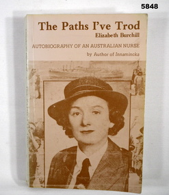
Book - BOOK, AUTOBIOGRAPHY, Elizabeth Burchill, "The Paths I've Trod", 1981/ 1984
... Paths I've Trod / Autobiography of an Australian Nurse" Books Military History WW2 Nurses Title page - handwritten, blue ink, author's signature "E. Burchill B.A., B Lits, R.N., R.M., I.W. (AUTHOR)/ Melbourne/ 1987" End papers - back - handwritten, blue ink. ("David/ 855937") name and no's have been crossed out. Soft cover book. Cover - cardboard, brown print on front, spine and back. Illustrated two ...Owner and donor details - see Cat No. 5836.3. "The Paths I've Trod / Autobiography of an Australian Nurse"Soft cover book. Cover - cardboard, brown print on front, spine and back. Illustrated two sepia toned photographs - front 1/2 portrait of author (1940, back - author receiving her Bachelor of Arts. 249 pages - cut, plain, white paper. Illustrated black and white photographs. Title page and endpapers back - handwritten signature and notes.Title page - handwritten, blue ink, author's signature "E. Burchill B.A., B Lits, R.N., R.M., I.W. (AUTHOR)/ Melbourne/ 1987" End papers - back - handwritten, blue ink. ("David/ 855937") name and no's have been crossed out.books, military history, ww2, nurses -
 Bendigo Military Museum
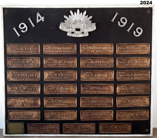
Honour Board - EAST BENDIGO PRIMARY SCHOOL HONOUR BOARD WW1, original plaques, post WW1
... Approximately two months later, on 16 June 1916, Arbor Day was celebrated at the school with the planting of an ‘Anzac Avenue’ along a path from the front gate on Strickland Road (‘the pathway’) to commemorate the landing of soldiers at Gallipoli. ...Approximately two months later, on 16 June 1916, Arbor Day was celebrated at the school with the planting of an ‘Anzac Avenue’ along a path from the front gate on Strickland Road (‘the pathway’) to commemorate the landing of soldiers at Gallipoli. ...The Bendigo East Primary School was opened in 1915. In 1916 it was decided to plant an ANZAC Avenue of trees and this was completed on 16 June 1916. The plaques were placed after WW1. The school was closed in 1998 and the plaques were relocated to the nearby White Hills Secondary College in Napier Street on this board. In the early 2000's the Honour Board was donated to what is now called the Bendigo Military Museum. One hundred years after planting, later in 2016 the trees were removed in controversial circumstances. On the board 8 never returned, there is 1 x "DCM" winner, 1 x "MC" winner and 1 x "MM" winner. There are 3 x Wright Brothers of which 2 never returned. The plaque states that the soldiers attended the school which is obvious they could not have due to the opening date. The following Heritage report suggests that the names were of individual soldiers who lived in the area. EXTRACT FROM HERITAGE COUNCIL VICTORIA 2016 SUBMISSIONS HEARING “The Bendigo East School (‘the school’) was officially opened by Mr Frank Tate, Director of Education, on 7 April 1916. Approximately two months later, on 16 June 1916, Arbor Day was celebrated at the school with the planting of an ‘Anzac Avenue’ along a path from the front gate on Strickland Road (‘the pathway’) to commemorate the landing of soldiers at Gallipoli. The school’s ‘Anzac Avenue’ was one of an estimated 37 known to have been planted by school children throughout Victoria during mid-1916 as part of a program led by the Education Department, which included a recommendation to schools on 18 May 1916 that commemorative avenues be planted (‘the 1916 plantings recommendation’). At around this time, avenues of honour were also planted across Victoria to commemorate fallen WWI soldiers (‘the wider commemorative plantings phenomenon’). There were other commemorative plantings at the Place away from the pathway (‘the other commemorative plantings’). Anzac Day was celebrated at the Place in the years subsequent to 1916 and on 11 December 1920 the school’s ‘Anzac Avenue’ was officially opened. Embossed copper plates, mounted on wood, were fixed in front of the trees in memory of individual soldiers from the district who had seen active service in WWI. There is evidence that as many as 32 plaques may have been made and affixed (‘the name plaques’). Plaques were removed from their locations at some stage before 1964, mounted on a board and displayed in the school building. These are now located and displayed at Bendigo Sub - Branch of the Returned Services League.” EAST BENDIGO HONOUR BOARD – COPPER PLAQUES (27 PLAQUES in total). 1. 2441 CPL G.V. LE KIM 60th BATT. M.M. (George Vincent LEE-KIM, born in Bendigo, Awarded Military Medal. RTA. NOK Father’s Address: C/- Strickland Rd, Bendigo). 2. 3821 PTE. E.B. HEM 20TH BATT. (Edward Bert Hem born in Bendigo. RTA. NOK Mother’s address: White Hills Post Office). 3. 3513 PTE. C.A. FOLEY 57th BATT. (Charles Albert Foley born in Bendigo. RTA. NOK Father’s address: Wilkie Street, Bendigo). 4. 5241 PTE. G. E. WRIGHT 6th BATT. † (George Edwin Wright born in Bendigo. KIA 8/12/1916. NOK Father’s address: 55 Charleston Rd. Bendigo). 5. 2663 L.CPL. N. E. DAVIS 60th BATT. (Norman Edward Davis born in Footscray. RTA. NOK Mother’s address: 193 Strickland Rd. Bendigo). 6. PTE. A. MOOG 16-6th BATT. † (5143 Adolph Moog born in Bendigo. Died of wounds received in action 8/12/1916, NOK Father’s address: Municipal Yards, Bendigo.) 7. 6515 SGT. W.A. BIRCHMORE DCM 11TH BATT. FIELD ARTILLERY (William Albert Birchmore born in Bendigo. Awarded DCM. RTA. NOK Mother’s address: Butler Street, California Gully) 8. 3924 PTE. J.P. NEWMAN 5TH BATT. † (392 (NAA) James Pausey Newman. Born in Bendigo. KIA 25/7/1916. NOK Father’s address Strickland Road, Bendigo) 9. 4865 PTE. H. T. NUGENT 5TH PIONEER BATT. † (also 4765 Hector Thomas Nugent born in Bendigo. KIA 26/11/1916. NOK Mother’s address: 55 Charleston Rd Bendigo). 10. 835 PTE. C.J. WRIGHT 7TH BATT. † (825(NAA) Charles Julian Wright. Born in Bendigo. KIA at Gallipoli 25/4/1915 NOK Father’s address 55 Charleston Rd Bendigo) 11. 5242 PTE. T.S. WRIGHT M.M. 6TH BATT. (Thomas Stanley Wright born in Bendigo. RTA. NOK Father’s address: 55 Charleston Road, Bendigo). 12. 13111 PTE. R.I. LEE 5TH FIELD AMBCE (19111 Robert Irwin Lee. Born in Kilcunda, Vic. RTA. NOK Wife’s address C/- Barnard Street, Bendigo) 13. 3731 DRIVER T.S. BROWN 5TH BATT.† (Thomas Sheridan Brown born in Bendigo. Died in the Field in France of Heart Failure. NOK Father’s address: Mundy Street, Bendigo). 14. 60999 PTE. J. SPENCE 5th BATT. (John Spence born in Bendigo. RTA. NOK Father’s address: 99 Talbot St, Brunswick) 15. 5127 PTE. S.A. LOY 7TH BATT. (Samuel Arthur John Loy. Born in White Hills, Bendigo. RTA Medical discharge. NOK Wife’s address C/- Hargreaves St Bendigo.) 16. 1649 PTE. A.M. HUTCHINSON 60TH BATT. (Alexander Morton Hutchison. (Note different spelling) born in Bendigo. RTA. NOK Mother’s address Wilkie Street, Bendigo). 17. 3035 PTE. R.J. FLACK 10TH – 7TH BATTs. † (Robert John Flack born in Bendigo. KIA France 17/8/1916. NOK Father’s address: Strickland Road, Bendigo). 18. 4558 PTE. J.J. O’BRIEN 60TH BATT.† (John James O’Brien born in Glenalbyn, Vic. KIA 28/9/1917. NOK Father’s address 68 Strickland Rd. Bendigo). 19. 5233 CPL. G. WHITTING MOTOR TRANSPT. COY. (George Whitting born in White Hills, Bendigo. RTA. NOK Mother’s address: 46 Baxter Street, Bendigo). 20. 5203 PTE. A.J. TATTERSALL 6TH BATTALION (Arthur James Tattersall born in Mandurang, Vic. RTA. NOK Wife’s address “Thornwell”, Bendigo East PO.) 21. 2ND LIEUT. K.G. EMONSON M.C. 38th BATT. (Keith Glanfield Emonson born in Sydney NSW. RTA – Medical discharge/ GSW head. NOK Father’s address: Strickland Road, Bendigo). 22. LIEUT. A.J. HAMPSON RAILWAY UNIT (Alfred John Hampson R/N 2300. Born in Bendigo. RTA. NOK wife’s address: 76 Addison St. Elwood, Vic). 23. 216 SIGNLR R.P. BROWN 38TH BATT † (Raymond Patrick Brown, born in Bendigo. KIA 28 May 1917. NOK. Mother’s address: 138 Mundy Street, Bendigo). 24. 15118 STAFF SGT. A. EMONSON 3RD L. H. F. AMBULANCE (Harry Allen Phipps Emonson born in Sydney NSW. RTA. NOK Father’s address Strickland Road, Bendigo, Vic). 25. 1724 CPL. L.J. CHAPPLE 5TH BATT. (Leslie John Chapple born in Bendigo. RTA. NOK Father’s address: Nolan Street, Bendigo) 26. 4557 PTE. E. O’BRIEN 60TH BATT. (Edward Charles O’ Brien, RTA. (NOK Father’s address: Strickland Rd, Bendigo). 27. 3557 SIGNLER F. H. LYALL 5TH BATT. (Francis Hubert Lyall born in Bendigo. RTA. NOK Father’s address: Strickland Rd, Bendigo). Honour Board, Bendigo East Primary School, timber backing with a white timber edging. At the top is a silver Rising Sun Badge with the dates in white "1914 & 1919". There are 27 bronze plaques, each has the Soldiers Regt Number, Name, Rank and Unit, for those that did not return there is a Cross added, if the Soldier won an award it is also added. At the bottom left hand corner is a brass plaque with details. Refer Aquisition for details. On the brass plaque, “These plaques were placed on the Avenue of trees at the school entrance on 20 December 1920. They were a memorial to those who enlisted from the Bendigo East School in the 1914 - 18 War. Mr R. J. Lee a Returned Soldier was Principal at this time”memorials-honour boards, military history-service records, metalcraft-bronze, east bendigo -
 Bendigo Military Museum
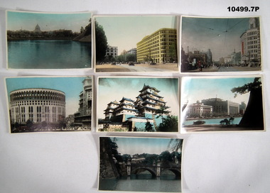
Photograph - STREET VIEWS, TOKYO, BCOF, c.1947
... paths. Tram tracks down middle of street. Overhead wires for trams visible. 4. Colour photograph of a high rise circular building. Pedestrians visible in front of building. Japanese character visible on front of building. 5. Colour photograph of a multi level Japanese Castle (Himeji Castle.) 6. Colour photograph of multi level buildings with a body of water and trees in foreground. 7, Colour photograph of a palatial building behind a two...paths. Tram tracks down middle of street. Overhead wires for trams visible. 4. Colour photograph of a high rise circular building. Pedestrians visible in front of building. Japanese character visible on front of building. 5. Colour photograph of a multi level Japanese Castle (Himeji Castle.) 6. Colour photograph of multi level buildings with a body of water and trees in foreground. 7, Colour photograph of a palatial building behind a two ...Photographs collected by Alva Marie Bennetts whilst deployed to BCOF, 1947-49. Part of the Bennetts collection. See catalogue No. 9726P for details of Alva Bennetts (No. VFX128835) service record.1. Colour photograph of a view across a body of water to a large building. 2. Colour photograph of a street lined with multi-storied buildings. Vehicles and pedestrians visible. 3. Colour photograph of a street lined with multi-storied buildings. Pedestrians on foot paths. Tram tracks down middle of street. Overhead wires for trams visible. 4. Colour photograph of a high rise circular building. Pedestrians visible in front of building. Japanese character visible on front of building. 5. Colour photograph of a multi level Japanese Castle (Himeji Castle.) 6. Colour photograph of multi level buildings with a body of water and trees in foreground. 7, Colour photograph of a palatial building behind a two arch bridge. Body of water in foreground. 1. Handwritten in black ink on back: “Japan's Diet Building” (The top part reminds me of the Shrine of Remembrance Melbourne). 2. Handwritten in black ink on back: Marunochi Building, Tokyo. 3. Handwritten in black ink on back: Main St Tokyo. 4. Handwritten in black ink on back: Nippon Theatre Off Limits to all troops 6. Handwritten in black ink on back: The middle building is General McArthur's H.Q.'s - a fine structure. 7. Handwritten in black ink on back: Entrance to the Imperial Palace, Tokyo. The palace has three moats around it. it is very heavily guarded, at the moment by Americans and Australian Air Force plus Japanese police 24/7/47'.alva bennetts, bcof, tokyo, japan -
 Ararat & District Historical Society (operating the Langi Morgala Museum)
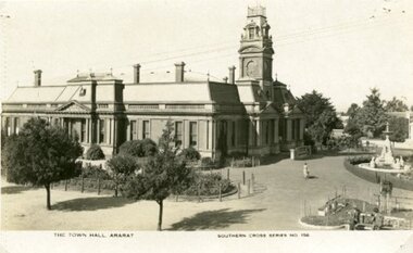
Postcard
... A fountain can be seen on the right and there are two garden beds. A woman is walking on a path between the Town Hall and fountain....A fountain can be seen on the right and there are two garden beds. A woman is walking on a path between the Town Hall and fountain. ...Part of the Rose Stereograph Co Armadale, VictoriaBlack and white postcard of Ararat Town Hall taken from a high position on the Vincent Street side of the building. A fountain can be seen on the right and there are two garden beds. A woman is walking on a path between the Town Hall and fountain.The Town Hall Ararat, Souther Cross Series 156 -
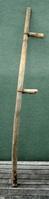 Orbost & District Historical Society
scythe handle, Early 20th century
... path for the tractors. This item is an example of a tool used by the early settlers of the Orbost district. scythe agricultural tool farming A curved wooden scythe handle with two nailed grips attached with metal rings. ...Scythes were used with a long sweeping movement which made them much less tiring for labourers to use than reaping hooks or sickles though they still involved great physical labour and considerable skill to perfect. Both hands were in use and the operator did not have to bend his back to reach down to the crop. Scythes were not used as often on farms after the mechanisation of harvesting. They were still used for cutting awkward shaped small plots and for opening a path for the tractors. This item is an example of a tool used by the early settlers of the Orbost district. A curved wooden scythe handle with two nailed grips attached with metal rings. There is no blade. There is a metal hook at the bottom.scythe agricultural tool farming -
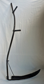 Orbost & District Historical Society
scythe, early -mid 20th century
... path for the tractors. This item is an example of a tool used by the early settlers of the Orbost district. scythe agriculture tool A curved iron blade with one sharp edge. It is attached to a curved hollow handle with two ...Scythes were used with a long sweeping movement which made them much less tiring for labourers to use than reaping hooks or sickles though they still involved great physical labour and considerable skill to perfect. Both hands were in use and the operator did not have to bend his back to reach down to the crop. Scythes were not used as often on farms after the mechanisation of harvesting. They were still used for cutting awkward shaped small plots and for opening a path for the tractors. This item is an example of a tool used by the early settlers of the Orbost district.A curved iron blade with one sharp edge. It is attached to a curved hollow handle with two extensions on one side where the scythe can be held by two hands.scythe agriculture tool -
 Federation University Historical Collection
Document - Document - Design, E J Barker: University of Melbourne: Bachelor of Mechanical Engineering; Civil Engineering 1 and 1A; Design of Welded Plate Girder, 1946
... two steel columns which have to be spaced 60 feet centre to centre. It needs to carry its own weight plus specified loads. This was part of Civil Engineering 1A . Jack chose to do Engineering while still at Footscray Technical School as it gave access to Diploma Courses and tertiary studies. This enabled him to enter the University of Melbourne and do a Bachelor in Mechanical Engineering - 1945, 1946, and 1947. In 1948 he did a Diploma in Education at Melbourne University. From this path...two steel columns which have to be spaced 60 feet centre to centre. It needs to carry its own weight plus specified loads. This was part of Civil Engineering 1A . Jack chose to do Engineering while still at Footscray Technical School as it gave access to Diploma Courses and tertiary studies. This enabled him to enter the University of Melbourne and do a Bachelor in Mechanical Engineering - 1945, 1946, and 1947. In 1948 he did a Diploma in Education at Melbourne University. From this path ...Assessment No 2 Project was to design a welded plate girder required in a building to span between two steel columns which have to be spaced 60 feet centre to centre. It needs to carry its own weight plus specified loads. This was part of Civil Engineering 1A . Jack chose to do Engineering while still at Footscray Technical School as it gave access to Diploma Courses and tertiary studies. This enabled him to enter the University of Melbourne and do a Bachelor in Mechanical Engineering - 1945, 1946, and 1947. In 1948 he did a Diploma in Education at Melbourne University. From this path he was able to follow a career in teaching and his first appointment was at the School of Mines in Ballarat, (SMB) 1949. He became the first Vice Principal of SMB in 1960 and then Principal in 1964 to 1976. From 1976 to his retirement in 1987, he was the Foundation Director of Ballarat College of Advanced Education (BCAE). The Library building at Mount Helen Campus is named after him.Manila folder with design assessment. Written descriptions and detailed drawings.e j barker, jack barker, melbourne university, engineering, diploma of mechanical engineering, diploma of electrical engineering, school of mines ballarat, smb, diploma in education, vice principal, principal, foundation director, ballarat college of advanced education, bcae, bachelor of mechanical engineering, library, mount helen campus, engineering drawing, design, specifications, manufacture, civil engineering, welded plate girder, 60 feet, steel columns -
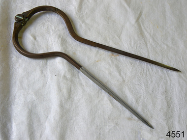 Flagstaff Hill Maritime Museum and Village
Dividers, Early 20th Century
... two points on a map or chart. Each point of the divider is places on a map point, then the distance between the points of the divider is measured against the scale of the chart or map. This helps determine the ship's path...two points on a map or chart. Each point of the divider is places on a map point, then the distance between the points of the divider is measured against the scale of the chart or map. This helps determine the ship's path ...Dividers are used by navigators to measure the distance between two points on a map or chart. Each point of the divider is places on a map point, then the distance between the points of the divider is measured against the scale of the chart or map. This helps determine the ship's path of travel, the distance travelled and the current location.Not very significant as not associated with any historical event or person, same pattern of dividers is available today from many retail outlets. Also item was probably made around 1940s to 1950sDividers; brass navigator's dividers with fine, stainless steel points. Made in Britain by W & H C (inscription). This navigational tool is used by a ship's navigator to mark the ship's position. Each end point of the divider is placed on a position on a chart or map, then the length between the points of the divider is measured on the chart's scale.Inscribed "British Made" and "W & H C". flagstaff hill, warrnambool, shipwrecked-coast, flagstaff-hill, flagstaff-hill-maritime-museum, maritime-museum, shipwreck-coast, flagstaff-hill-maritime-village, navigational dividers, navigational tool, dividers made by w & hc, w & hc britain -
 Eltham District Historical Society Inc
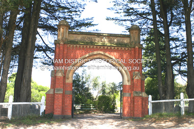
Photograph - Digital Photograph, Alan King, Memorial Arch Gateway, Nillumbik Cemetery, Diamond Creek, 23 January 2008
... path. His son John Lawrence, who is buried elsewhere, had been a Mayor of the City of Heidelberg. George Martin Pizzey gave a hall, for what was to become The St John’s Anglican Church in Diamond Creek. He was a Crimean War veteran, mason and leather goods manufacturer in Melbourne, who died in 1915. The two...path. His son John Lawrence, who is buried elsewhere, had been a Mayor of the City of Heidelberg. George Martin Pizzey gave a hall, for what was to become The St John’s Anglican Church in Diamond Creek. He was a Crimean War veteran, mason and leather goods manufacturer in Melbourne, who died in 1915. The two ...The Nillumbik Cemetery is of historical, architectural, aesthetic and social significance at a Regional level (North-east Melbourne). The memorial arch is of State significance. Nillumbik Cemetery, which was established in 1867, is of historical and social significance for its association with the early history of Diamond Creek and as a record of the pioneering families of the district. Significant graves include those of the famous writer Alan Marshall, author of 'I Can Jump Puddles', footballer Gordon Coventry, and William Ellis, notable early settler and benefactor. The 1897 Tudor/Gothic revival memorial arch, bequeathed by William Ellis, is a rare design in ornamental gateways and is relatively large for the size of the cemetery. It is unique in Victoria as a cemetery gateway arch. The burial ground has associated structures, such as the hexagonal timber sexton's office, post and wire fence and picket hand gate along Main Street, all probably built in the early twentieth century. Covered under Heritage Overlay, Nillumbik Planning Scheme. National Trust of Australia (Victoria) - Regional significance Published: Nillumbik Now and Then / Marguerite Marshall 2008; photographs Alan King with Marguerite Marshall.; p83 Entering Nillumbik Cemetery through an ornamental gateway and shaded by the Monterey Cypress hedge helps one leave the busy world outside and contemplate yesterday’s Diamond Creek. The gateway, classified by the National Trust of Australia (Victoria), and inscribed with ‘JANVA VITAE’ (gate of life), was a gift from a distinguished pioneer, William Ellis. Ellis, who was an original trustee of the Nillumbik Cemetery representing the Primitive Methodists and a successful farmer, bequeathed £100 to build the red-brick and carved stone gateway in 1887. In 1867 surveyor Edward Bage had set aside two acres (0.8ha) now 35 Main Street, for this cemetery, in what was then called the village of Nillumbik. Several earlier burials on private lands in the district might have been exhumed and re-interred in the new cemetery. The first burials in the cemetery are thought to be of ‘a Chinaman who hanged himself from a tree behind the Church of England’ and ‘another man who was drowned in a water-hole behind the same church’.1 The 1000 or so graves in the cemetery are grouped into five denominational sections: two Anglican and one each for the Methodist (the largest), Catholic and Presbyterian Churches. It is believed that several unmarked graves are of Aborigines and Chinese miners.2 Perhaps the most famous person buried in the cemetery was author Alan Marshall, who died in 1984 and wrote, among other books, I Can Jump Puddles. Surprisingly his grave is particularly modest consisting of only a grassed plot with a tiny boulder and a simple bronze plaque. It lies about halfway down the main path, at the west and third row back. The first European, interred at the cemetery on July 9, 1869, was Hannah, aged 13 years eight months, daughter of local orchardist John Lawrey and wife Honor.3 Each grave has a story which reflects a rich history. Phillip Cummings, who died in 1884, provided the barn for Diamond Creek’s first school, run by the Primitive Methodist Church. The barn stood at the corner of Phipps Crescent and the main road.4 Former Eltham Shire councillor George Stebbings, who died in 1896, built several prominent buildings in the district, including Shillinglaw Cottage in Eltham.5 The grave of miner James Joseph Whyte, who died in 1908, is a reminder of Diamond Creek’s gold mining history. At age 51, Whyte died from a rock fall in the Diamond Mine, Diamond Creek. Diamond Creek’s first butcher, Patrick Ryan, became President of the Shire of Heidelberg and Chairman of the Eltham Hurstbridge Railway Trust. A former gold miner, he was grandfather of local historian Reverend Jock Ryan. He was buried in an unmarked grave halfway down the central path. His son John Lawrence, who is buried elsewhere, had been a Mayor of the City of Heidelberg. George Martin Pizzey gave a hall, for what was to become The St John’s Anglican Church in Diamond Creek. He was a Crimean War veteran, mason and leather goods manufacturer in Melbourne, who died in 1915. The two world wars took a heavy toll of locals with 54 personnel buried here, two thirds of whom served in World War One. A sporting pioneer was Greensborough District Cricket Club founder, Andrew Webb, who was buried in 1971. Politician Roy Mountford Vale (Monte), who died in 1977, was a Member of the Legislative Assembly of Greensborough, and a founding councillor and president of the Diamond Valley Shire. Modern-day residents are also remembered in this cemetery. The tragic Ash Wednesday bushfires took their toll on the district: William Marsden of Panton Hill CFA died, aged 39, fighting bushfires at Upper Beaconsfield in 1983.6 Several graves tell of those who held distinguished positions overseas, including William Constable, who died in 1989. Constable was artistic director of a ballet company, art director of more than 30 films for London-based film productions, and was awarded best Film Art Director at the Moscow Film Festival in 1960.This collection of almost 130 photos about places and people within the Shire of Nillumbik, an urban and rural municipality in Melbourne's north, contributes to an understanding of the history of the Shire. Published in 2008 immediately prior to the Black Saturday bushfires of February 7, 2009, it documents sites that were impacted, and in some cases destroyed by the fires. It includes photographs taken especially for the publication, creating a unique time capsule representing the Shire in the early 21st century. It remains the most recent comprehenesive publication devoted to the Shire's history connecting local residents to the past. nillumbik now and then (marshall-king) collection, diamond creek, memorial arch, gateway, nillumbik cemetery, william ellis -
 Glen Eira Historical Society
Photograph, Beauville Avenue, 8, Murrumbeena, 2001
... Other features include a square enclosed porch with two decorative arched entrances with steps, tiled roof, green and yellow striped awning, the word "eight" written on the front of the house, concrete paths and driveway and a low unpainted brick fence beside the driveway....Other features include a square enclosed porch with two decorative arched entrances with steps, tiled roof, green and yellow striped awning, the word "eight" written on the front of the house, concrete paths and driveway and a low unpainted brick fence beside the driveway. ...Originally labelled "Beauville Estate, Established 1936, Still Thriving 65 years on, 10th March 2001", the Beauville Estate Album contains colour photographs of houses in the Estate. They were taken around the time of the Beauville Estate’s 65th Heritage Celebration held on 10/03/2001 and donated to the Caulfield Historical Society shortly afterwards. Photographer Bev Baxter. See also 2104A-10.City of Glen Eira’s Heritage Management Plan Vol 2 p79 (this is p84 of the pdf version) – HO12 Beauville Estate and environs, Murrumbeena: The Beauville Historic Area is important at the State level as the first large housing estate undertaken by the AV Jennings Construction Co, later Jennings Group Limited, Victoria’s largest home builder. It is important also as a very early estate development incorporating a range of features other than houses and including made roads, shops and recreation facilities. In this respect it was the forerunner of the comprehensively planned housing estate of the post war era. The estate is distinguished by its aesthetic values, as is the earlier and comparable Hillcrest Estate, which are formed by a combination of restrained diversity in house styles, with the exception of no. 30 in the emerging International style, and by a landscaped garden environment. Colour photograph of white rendered house with unpainted brick features. Other features include a square enclosed porch with two decorative arched entrances with steps, tiled roof, green and yellow striped awning, the word "eight" written on the front of the house, concrete paths and driveway and a low unpainted brick fence beside the driveway.murrumbeena, houses, beauville avenue, architectural styles, 1930's, inter war style, a.v. jennings, av jennings, jennings, brick houses, beauville estate, porches, arches, sir albert victor jennings, rendered houses, a v jennings construction co, beauville estate heritage area, glen eira city council, architectural features, jennings group limited, land subdivision, gardens, beauville historic area, chimneys, brick fences, striped awnings -
 Glen Eira Historical Society
Photograph, Lindsay Avenue, 40, Murrumbeena, 2001
... Other features include a porch with two arches and separate rectangular entry from the path, arched side gate in a wall attached to the house at the side of the drive, feature work on all arches and chimney, white framed sash windows plus a long narrow white window to right of the porch, tiled roof, tall and wide chimney and low unpainted brick fence in the foreground with "40" on the brick pillar beside the drive....Other features include a porch with two arches and separate rectangular entry from the path, arched side gate in a wall attached to the house at the side of the drive, feature work on all arches and chimney, white framed sash windows plus a long narrow white window to right of the porch, tiled roof, tall and wide chimney and low unpainted brick fence in the foreground with "40" on the brick pillar beside the drive. ...Originally labelled "Beauville Estate, Established 1936, Still Thriving 65 years on, 10th March 2001", the Beauville Estate Album contains colour photographs of houses in the Estate. They were taken around the time of the Beauville Estate’s 65th Heritage Celebration held on 10/03/2001 and donated to the Caulfield Historical Society shortly afterwards. Photographer unknown. City of Glen Eira’s Heritage Management Plan Vol 2 p79 (this is p84 of the pdf version) – HO12 Beauville Estate and environs, Murrumbeena: The Beauville Historic Area is important at the State level as the first large housing estate undertaken by the AV Jennings Construction Co, later Jennings Group Limited, Victoria’s largest home builder. It is important also as a very early estate development incorporating a range of features other than houses and including made roads, shops and recreation facilities. In this respect it was the forerunner of the comprehensively planned housing estate of the post war era. The estate is distinguished by its aesthetic values, as is the earlier and comparable Hillcrest Estate, which are formed by a combination of restrained diversity in house styles, with the exception of no. 30 in the emerging International style, and by a landscaped garden environment. Colour photograph of an unpainted variegated brown brick house. Other features include a porch with two arches and separate rectangular entry from the path, arched side gate in a wall attached to the house at the side of the drive, feature work on all arches and chimney, white framed sash windows plus a long narrow white window to right of the porch, tiled roof, tall and wide chimney and low unpainted brick fence in the foreground with "40" on the brick pillar beside the drive.40murrumbeena, houses, architectural styles, 1930's, inter war style, a.v. jennings, av jennings, brick houses, beauville estate, porches, lindsay avenue, sir albert victor jennings, a v jennings construction co, beauville estate heritage area, glen eira city council, architectural features, jennings group limited, land subdivision, gardens, beauville historic area, jennings, arches, chimneys, brick features, sash windows, brick fences -
 Bendigo Historical Society Inc.
Photograph - TOORAK BOARDING HOUSE, MOLLISON STREET, 1914
... path and group. Group composed of 29 men in suits (mostly young), twelve women and two children. ...path and group. Group composed of 29 men in suits (mostly young), twelve women and two children. ...Black and white photograph of group posed in garden outside verandah brick building (iron lace) and sign 'Toorak' over central entrance. Palm trees on either side of path and group. Group composed of 29 men in suits (mostly young), twelve women and two children. Inscriptions: on front - 'GP68, WH Robinson, Photo Bendigo'. On back - 'Boarders 'Toorak' July 1914 Bendigo', RHSV stamp'. History: Prev. Acc. No. GP68. H Mainka (18/11/1999): 'Toorak' Boarding House in Mollison St between Mitchell & Williamson St (railway side). Neville Stilwell owned and Bev Stilwell may still own it. (informants - Norma Cowling, May Macauley. Previous owner Susan Eleanor McMahon, age 88, died at 135 Mollison Street, Bendigo. Cemetery RC 2nd interment. Last interment 24/8/1936. Burial 19/1/1948 at 2.00pm.WH Robinson, Bendigoperson, group -
 Bendigo Historical Society Inc.
Photograph - OLIVE PELL COLLECTION: STEREOSCOPE OF A CHURCH
... two smaller side windows. The top of the front pitch of the roof is a finial. To the right behind a tree is a church spire. A stone fence is in the foreground with a white gate and walking path. ...two smaller side windows. The top of the front pitch of the roof is a finial. To the right behind a tree is a church spire. A stone fence is in the foreground with a white gate and walking path. ...A Stereoscope photograph of a Church. A grey stone building with three entrances two at the front and one to the left side, a large front stained glass window with two smaller side windows. The top of the front pitch of the roof is a finial. To the right behind a tree is a church spire. A stone fence is in the foreground with a white gate and walking path. A large tree is in the middle of the picture.buildings, church, stone, grey stone church. -
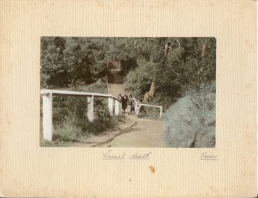 Bendigo Historical Society Inc.
Photograph - LOVER'S WALK, COWES
... 3 adult females in cloche hats and overcoats, two small females on scenic walk. Path through bush and trees with white post and rail fence. ...3 adult females in cloche hats and overcoats, two small females on scenic walk. Path through bush and trees with white post and rail fence. ...coloured photo: family group ? 3 adult females in cloche hats and overcoats, two small females on scenic walk. Path through bush and trees with white post and rail fence. On front board, handwritten ' Lovers Walk, Cowes' Won by Mr. L. Batchelder ( Bendigo Photographer's family ? ) ' Gents Rope Quoits/Bay View Cowes, Feb. 1933 'A.J. Murray, Ciommercial Photographer, Photo Shop, Cosesplace -
 Halls Gap & Grampians Historical Society
Map - Coloured
... The mining Department had paid L300 for its construction and, when completed, the track was "three miles and 30 chains in length, the side cuttings at the narrowest part being 10 feet between" and "the watercourses which cross the track at various points" having been "filled up with rocks rolled down the sides of the hills, and consequently there can be no damage caused by bushfires which destroyed the former wooden bridges erected on the old track to Wakeham's saw-mill, the remains of which are still to be seen at the side of the diggings" The article goes on to further describe the track as one which "can with ease travel with a two horse conveyance either up or down" and that the workmen engaged in the construction of the track would be attending "a ball that night at McKeon's farm near the mouth of the gap to celebrate the successful completion of the undertaking". 1900s At what time the bridle path was extended beyond Valley Gap to the Wartook basin on the Mt. ...The mining Department had paid L300 for its construction and, when completed, the track was "three miles and 30 chains in length, the side cuttings at the narrowest part being 10 feet between" and "the watercourses which cross the track at various points" having been "filled up with rocks rolled down the sides of the hills, and consequently there can be no damage caused by bushfires which destroyed the former wooden bridges erected on the old track to Wakeham's saw-mill, the remains of which are still to be seen at the side of the diggings" The article goes on to further describe the track as one which "can with ease travel with a two horse conveyance either up or down" and that the workmen engaged in the construction of the track would be attending "a ball that night at McKeon's farm near the mouth of the gap to celebrate the successful completion of the undertaking". 1900s At what time the bridle path was extended beyond Valley Gap to the Wartook basin on the Mt. ...Background on Bridle Path up Stony Creek Gorge Pre 1840 C. B. Hall, squatter on Mokepilly Run 1841-1842, first European to discover the Fyans Creek valley, the entrance of which became known as Hall's Gap. He later recorded that he followed a number of tracks which he assumed had been made by the Aboriginies and described one as "leading up a wild romantic glen and over on to the source of the Glenelg River". This could well have been the route taken up Stony Creek gorge by the first timber-cutters in this part of the Grampians to the saddle between the Wonderland and Mt. Difficult ranges known as Valley Gap 1850s/60s Timber cutters and shingle splitters were reported to be moving into the eastern side of the Grampians and by the mid 1860s there were a number of families connected to the supplying of timber to Pleasant Creek living in the "Hall's Gap ranges". John Wakeham, the first store owner in Pleasant Creek in 1854, established a timer-mill in upper Stony Creek Gorge in the late 1850s. Wakeham is credited for the clearing and levelling of the first bridle-path up the gorge. 1870s By the mid 1870s the track had been extended over Valley Gap to the Victoria Forest (the upper region of the Victoria Valley). McKeon's bullock team was known to have hauled red gum from the Valley to Stawell in the late 1870s and the 1880s. 1880s In 1887 an article in the Pleasant Creek news describes the Stony Creek Gorge track as "being a ledge alongside the mountain range, formed in the early days with the aid of earth and timber, along which the bullock teams used to travel to Horsham and plains of the Wimmera beyond." 1890s Gold was discovered in the catchment area of Stony Creek and by the end of the 1890s a new track was built from "near the junction of Fyan's and Stony Creeks, up the gorge to the diggings settlement. The mining Department had paid L300 for its construction and, when completed, the track was "three miles and 30 chains in length, the side cuttings at the narrowest part being 10 feet between" and "the watercourses which cross the track at various points" having been "filled up with rocks rolled down the sides of the hills, and consequently there can be no damage caused by bushfires which destroyed the former wooden bridges erected on the old track to Wakeham's saw-mill, the remains of which are still to be seen at the side of the diggings" The article goes on to further describe the track as one which "can with ease travel with a two horse conveyance either up or down" and that the workmen engaged in the construction of the track would be attending "a ball that night at McKeon's farm near the mouth of the gap to celebrate the successful completion of the undertaking". 1900s At what time the bridle path was extended beyond Valley Gap to the Wartook basin on the Mt. Difficult Range has not yet been determined. However, it is known that, by the turn of the century, people were travelling between Halls Gap and the caretakers' residence at Wartook Reservoir along what was now known as the "Bluff Road. Wartook's embankment had been constructed in 1887 and at that time there was already a track from Rosebrook Station homestead (near the present day Wartook Pottery) to the reservoir. Philip Rose owned both Rosebrook and Wartook Stations from the mid 1840s to the late 1850s and had regularly leased the Wartook basin to Cobb & Co. to rest horses there. 1920s Following the war of 1914-1918, tourism really took off in the Grampians, and Halls Gap rapidly grew. People would travel as far as they could on the many tracks then hike to the many lookouts being discovered by local tour guides. This led to the need for access across the range so that horse riders and the increasing number of vehicles could travel between Horsham and Halls Gap. To this end, the Bluff Road was improved and extended on 1929 and at its opening in March, 1930, by Lady Somers it was renamed the Mt. Victory Road.Map of Mt Victory Road and othersaccess routes, mt victory rd, bridle path, roads -
 Halls Gap & Grampians Historical Society
Photograph - B/W, C 1898
... path) near Halls Gap. ACCESS ROUTES Jinker Track PEOPLE Galbraith A woman and five small children, two boys and three girls, on a dirt track with trees and rocks on either side of it. ...The picture shows Maggie Galbraith and five small children (identities unknown) beside a jinker track (bridal path) near Halls Gap.A woman and five small children, two boys and three girls, on a dirt track with trees and rocks on either side of it.access routes, jinker track, people, galbraith -
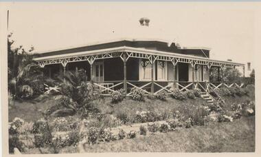 Phillip Island and District Historical Society Inc.
Photograph, Warley Hospital, circa 1923
... path & verandah. Palm to left of photo and roof of house in background at right. two men and a nurse standing in garden near stairs....path & verandah. Palm to left of photo and roof of house in background at right. two men and a nurse standing in garden near stairs. ...Donated by Jean BainBlack & White photograph of Warley Hospital with verandah & steps down to garden path. Small shrubs line the path & verandah. Palm to left of photo and roof of house in background at right. two men and a nurse standing in garden near stairs.On Back: "Warley Hospital Cowes"warley hospital cowes, phillip island