Showing 118 items matching "thistle street"
-
 Surrey Hills Historical Society Collection
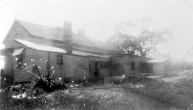
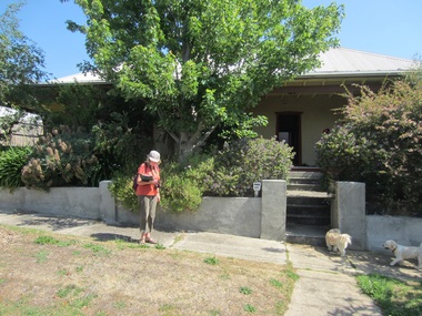
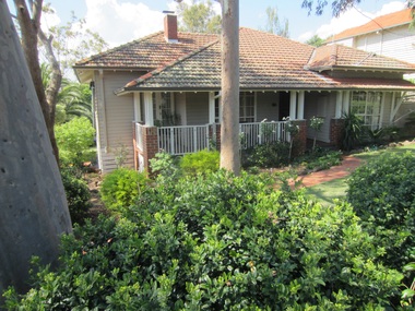
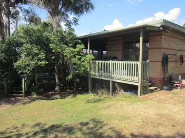
Photograph, 6a Thistle Street, Surrey Hills, 1924
... 6a Thistle Street, Surrey Hills......thistle street...It became 6A Thistle Street. According to the Alan Holt property register Rachel Sweetnam owned the property prior to 1890 and a family tree on Ancestry.com has that it was owned by her in c1886. ...6a Thistle Street, Surrey Hills, Victoria, Australia...In the background a mature eucalypt tree can be seen. 6a Thistle Street, Surrey Hills Photograph ...One of the oldest homes in Surrey Hills. The photo was taken in 1924 when the property was purchased by Mr John Francis Evans, father of Mrs Lillian Austin. The Evans family came from Gembrook. John Evans was born in Wales; he and his wife Mary had 3 children, 2 daughters and one son. Mary Evans pre-deceased her husband, who died on 23 October 1924 at Hillsborough, 6A Thistle Street. The first owner of the property was Mrs Rachel Sweetnam (nee Lewis) who married Thomas Edward Sweetnam on 24 September 1884 at St John's Church, Camberwell. REF: THE ARGUS 4 Oct 1884 Thomas second eldest surviving son of Matthew Sweetnam married to Rachel (Ray) third eldest daughter of Captain T.D. Lewis, Culm Haven, Camberwell. Thomas was active in land sales and variously described as a land agent, real estate agent and auctioneer. The property - Hillsboro or Hillsborough - was originally a house on a farm of 10 acres owned by her. It became 6A Thistle Street. According to the Alan Holt property register Rachel Sweetnam owned the property prior to 1890 and a family tree on Ancestry.com has that it was owned by her in c1886. It is likely that at this stage the property was an investment rather than the Sweetnam's family residence. Other property owners or residents are: 1890 Selina Gaylor 1900 Stephen Pullen 1910 William Murray (draftsman) 1920 George C Hughes 1930 Arthur Leslie Austin (tram driver) 1980 Mrs Lillian Evelyn Austin Lillian Austin died on 19 August 1983 and the property was sold that year for $87,000. The house is still extant (January 2025). Note that we also have material / photos regarding George Hughes and family.Black and white photo of a timber home with brick chimneys and a (?) corrugated iron roof. There are sheds and outbuildings attached to the house. The garden looks untended. In the background a mature eucalypt tree can be seen.houses, hillsboro, timber houses, mrs lillian austin, hillsborough, selina gaylor, stephen pullen, william murray, george hughes, arthur austin, john francis evans, thistle street -
 Surrey Hills Historical Society Collection
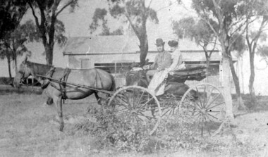
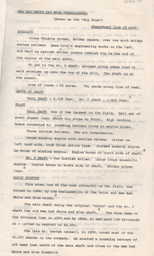
Photograph, 'Hillsboro' or "Hillsborough' - 6a Thistle Street, Surrey Hills, pre-1890
... 'Hillsboro' or "Hillsborough' - 6a Thistle Street, Surrey Hills......thistle street...The photo was found behind a mantelpiece in the house at 6A Thistle Street while it was being renovated. It is thought to be of the first owner, Mrs Rachel Sweetnam (nee Lewis) and her husband, Thomas Edward Sweetnam. ...'Hillsboro' or "Hillsborough' - 6a Thistle Street, Surrey Hills Photograph ...The photo was found behind a mantelpiece in the house at 6A Thistle Street while it was being renovated. It is thought to be of the first owner, Mrs Rachel Sweetnam (nee Lewis) and her husband, Thomas Edward Sweetnam. They were married on 24 September 1884 at St John's Church, Camberwell. REF: THE ARGUS 4 Oct 1884 Thomas second eldest surviving son of Matthew Sweetnam married to Rachel (Ray) third eldest daughter of Captain T.D. Lewis, Culm Haven, Camberwell. Thomas was active in land sales and variously described as a land agent, real estate agent and auctioneer. The property - Hillsboro or Hillsborough - was originally a house on a farm of 10 acres owned by her. It became 6A Thistle Street. According to the Alan Holt property register Rachel Sweetnam owned the property prior to 1890 and a family tree on Ancestry.com has that it was owned by her in c1886. It is likely that it was an investment rather than a family residence. Thomas Sweetnam was President of the Boroondara Shire 1888/89 and a councillor from 1886-1891. During his time as Shire councillor in 1887 he was charged with assaulting Charles A. Chandler, a window blind manufacturer, in response to an ‘insulting note’ left at Sweetnam’s house. Sweetnam was fined two guineas and 31 shillings. Sweetnam was also President of the Camberwell Gun Club from around 1890 – 91. In 1893 he relocated to Ferntree Gully, where he contested for the municipality’s North Riding council seat. Multiple references can be found on Trove. Note that the gentleman in this photo does bear a resemblance to Thomas Sweetman, President of Boroondara Shire in 1888-1889 found in the City of Boroondara Library Service mayoral portrait collection. No known photo of Rachel Sweetnam. Other property owners or residents are: 1890 Selina Gaylor 1900 Stephen Pullen 1910 William Murray (draftsman) 1920 George C Hughes 1930 Arthur Leslie Austin (tram driver) 1980 Mrs Lillian Evelyn Austin Sold in 1983 for $87,000. The house is still extant (January 2025). Note that we also have material / photos regarding George Hughes and family.This photo is one of the earliest photos of residences of Surrey Hills.Black and white photo of a woman and man in a buggy behind which is a simple house with a verandah at one end, surrounded by eucalypt trees.hillsboro, house names, thistle street, horse-drawn vehicle, clothing and dress, hillsborough, rachel sweetnam, rachel lewis, thomas sweetnam, selina gaylor, stephen pullen, william murray, george hughes, arthur austin, lillian austin -
 Bendigo Historical Society Inc.
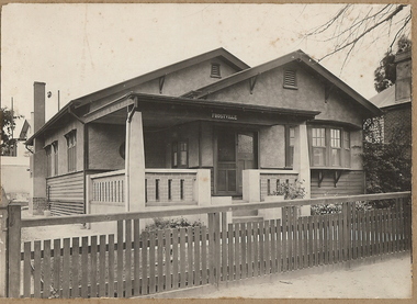
Photograph - T C WATTS & SON COLLECTION: THISTLE STREET, BENDIGO, 1931
... T C WATTS & SON COLLECTION: THISTLE STREET, BENDIGO...On back of photo: A. McIntosh, Thistle Street, £1000 sewered or £950 plus sewer, 15.10.31' 2012 photo of house attached to record....Photograph T C WATTS & SON COLLECTION: THISTLE STREET, BENDIGO ...Black and white photographs (2) mounted on rectangular brown board. House, California-type bungalow wood and rough cast construction, 2 gables, bow window on right. Large square return verandah with brick and concrete balustrade. 2 double and 1 single window on side plus 1 chimney ( kitchen ) Name of house 'Frostville' centre beam of porch. Wooden slat front fence. On back of photo: A. McIntosh, Thistle Street, £1000 sewered or £950 plus sewer, 15.10.31' 2012 photo of house attached to record.Frank A. Jeffree Photo Bendigo [In Brown]bendigo, business, t c watts and son, s -
 Surrey Hills Historical Society Collection
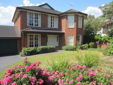
Photograph - 1 Thistle Street, Surrey Hills, The Street Where You Live Project
... 1 Thistle Street, Surrey Hills...The Street Where You Live Project Photograph 1 Thistle Street, Surrey Hills ...Photos documenting this address as part of a photographic series undertaken by volunteer photographers during 2013 and 2014 for The Street Where You Live Project. This was organised through the Surrey Hills Neighbourhood Centre and covered the postcode 3127 in the cities of Boroondara and Whitehorse.These photos provide a snapshot of real estate in the suburbs of Mont Albert and Surrey Hills during a period of rapid change with many properties on large blocks demolished to create higher density residential development or renewal of single dwellings. At particular risk were properties not covered by heritage overlays, in particular interwar housing and post 1950's housing. -
 Surrey Hills Historical Society Collection
Photograph - 1A Thistle Street, Surrey Hills, The Street Where You Live Project
... 1A Thistle Street, Surrey Hills...The Street Where You Live Project Photograph 1A Thistle Street, Surrey Hills ...Photos documenting this address as part of a photographic series undertaken by volunteer photographers during 2013 and 2014 for The Street Where You Live Project. This was organised through the Surrey Hills Neighbourhood Centre and covered the postcode 3127 in the cities of Boroondara and Whitehorse.These photos provide a snapshot of real estate in the suburbs of Mont Albert and Surrey Hills during a period of rapid change with many properties on large blocks demolished to create higher density residential development or renewal of single dwellings. At particular risk were properties not covered by heritage overlays, in particular interwar housing and post 1950's housing. -
 Surrey Hills Historical Society Collection
Photograph - 1B Thistle Street, Surrey Hills, The Street Where You Live Project
... 1B Thistle Street, Surrey Hills...The Street Where You Live Project Photograph 1B Thistle Street, Surrey Hills ...Photos documenting this address as part of a photographic series undertaken by volunteer photographers during 2013 and 2014 for The Street Where You Live Project. This was organised through the Surrey Hills Neighbourhood Centre and covered the postcode 3127 in the cities of Boroondara and Whitehorse.These photos provide a snapshot of real estate in the suburbs of Mont Albert and Surrey Hills during a period of rapid change with many properties on large blocks demolished to create higher density residential development or renewal of single dwellings. At particular risk were properties not covered by heritage overlays, in particular interwar housing and post 1950's housing. -
 Surrey Hills Historical Society Collection
Photograph - 2 Thistle Street, Surrey Hills, The Street Where You Live Project
... 2 Thistle Street, Surrey Hills...The Street Where You Live Project Photograph 2 Thistle Street, Surrey Hills ...Photos documenting this address as part of a photographic series undertaken by volunteer photographers during 2013 and 2014 for The Street Where You Live Project. This was organised through the Surrey Hills Neighbourhood Centre and covered the postcode 3127 in the cities of Boroondara and Whitehorse.These photos provide a snapshot of real estate in the suburbs of Mont Albert and Surrey Hills during a period of rapid change with many properties on large blocks demolished to create higher density residential development or renewal of single dwellings. At particular risk were properties not covered by heritage overlays, in particular interwar housing and post 1950's housing. -
 Surrey Hills Historical Society Collection
Photograph - 3 Thistle Street, Surrey Hills, The Street Where You Live Project
... 3 Thistle Street, Surrey Hills...The Street Where You Live Project Photograph 3 Thistle Street, Surrey Hills ...Photos documenting this address as part of a photographic series undertaken by volunteer photographers during 2013 and 2014 for The Street Where You Live Project. This was organised through the Surrey Hills Neighbourhood Centre and covered the postcode 3127 in the cities of Boroondara and Whitehorse.These photos provide a snapshot of real estate in the suburbs of Mont Albert and Surrey Hills during a period of rapid change with many properties on large blocks demolished to create higher density residential development or renewal of single dwellings. At particular risk were properties not covered by heritage overlays, in particular interwar housing and post 1950's housing. -
 Surrey Hills Historical Society Collection
Photograph - 4 Thistle Street, Surrey Hills, The Street Where You Live Project
... 4 Thistle Street, Surrey Hills...The Street Where You Live Project Photograph 4 Thistle Street, Surrey Hills ...Photos documenting this address as part of a photographic series undertaken by volunteer photographers during 2013 and 2014 for The Street Where You Live Project. This was organised through the Surrey Hills Neighbourhood Centre and covered the postcode 3127 in the cities of Boroondara and Whitehorse.These photos provide a snapshot of real estate in the suburbs of Mont Albert and Surrey Hills during a period of rapid change with many properties on large blocks demolished to create higher density residential development or renewal of single dwellings. At particular risk were properties not covered by heritage overlays, in particular interwar housing and post 1950's housing. -
 Surrey Hills Historical Society Collection
Photograph - 5 Thistle Street, Surrey Hills, The Street Where You Live Project
... 5 Thistle Street, Surrey Hills...The Street Where You Live Project Photograph 5 Thistle Street, Surrey Hills ...Photos documenting this address as part of a photographic series undertaken by volunteer photographers during 2013 and 2014 for The Street Where You Live Project. This was organised through the Surrey Hills Neighbourhood Centre and covered the postcode 3127 in the cities of Boroondara and Whitehorse.These photos provide a snapshot of real estate in the suburbs of Mont Albert and Surrey Hills during a period of rapid change with many properties on large blocks demolished to create higher density residential development or renewal of single dwellings. At particular risk were properties not covered by heritage overlays, in particular interwar housing and post 1950's housing. -
 Surrey Hills Historical Society Collection
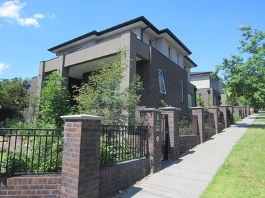
Photograph - 6 Thistle Street, Surrey Hills, The Street Where You Live Project
... 6 Thistle Street, Surrey Hills...The Street Where You Live Project Photograph 6 Thistle Street, Surrey Hills ...Photos documenting this address as part of a photographic series undertaken by volunteer photographers during 2013 and 2014 for The Street Where You Live Project. This was organised through the Surrey Hills Neighbourhood Centre and covered the postcode 3127 in the cities of Boroondara and Whitehorse.These photos provide a snapshot of real estate in the suburbs of Mont Albert and Surrey Hills during a period of rapid change with many properties on large blocks demolished to create higher density residential development or renewal of single dwellings. At particular risk were properties not covered by heritage overlays, in particular interwar housing and post 1950's housing. -
 Surrey Hills Historical Society Collection
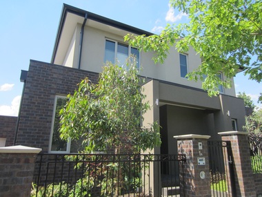
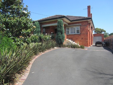
Photograph - 6A Thistle Street, Surrey Hills, The Street Where You Live Project
... 6A Thistle Street, Surrey Hills...The Street Where You Live Project Photograph 6A Thistle Street, Surrey Hills ...Photos documenting this address as part of a photographic series undertaken by volunteer photographers during 2013 and 2014 for The Street Where You Live Project. This was organised through the Surrey Hills Neighbourhood Centre and covered the postcode 3127 in the cities of Boroondara and Whitehorse.These photos provide a snapshot of real estate in the suburbs of Mont Albert and Surrey Hills during a period of rapid change with many properties on large blocks demolished to create higher density residential development or renewal of single dwellings. At particular risk were properties not covered by heritage overlays, in particular interwar housing and post 1950's housing. -
 Surrey Hills Historical Society Collection
Photograph - 7 Thistle Street, Surrey Hills, The Street Where You Live Project
... 7 Thistle Street, Surrey Hills...The Street Where You Live Project Photograph 7 Thistle Street, Surrey Hills ...Photos documenting this address as part of a photographic series undertaken by volunteer photographers during 2013 and 2014 for The Street Where You Live Project. This was organised through the Surrey Hills Neighbourhood Centre and covered the postcode 3127 in the cities of Boroondara and Whitehorse.These photos provide a snapshot of real estate in the suburbs of Mont Albert and Surrey Hills during a period of rapid change with many properties on large blocks demolished to create higher density residential development or renewal of single dwellings. At particular risk were properties not covered by heritage overlays, in particular interwar housing and post 1950's housing. -
 Surrey Hills Historical Society Collection
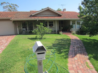
Photograph - 8 Thistle Street, Surrey Hills, The Street Where You Live Project
... 8 Thistle Street, Surrey Hills...The Street Where You Live Project Photograph 8 Thistle Street, Surrey Hills ...Photos documenting this address as part of a photographic series undertaken by volunteer photographers during 2013 and 2014 for The Street Where You Live Project. This was organised through the Surrey Hills Neighbourhood Centre and covered the postcode 3127 in the cities of Boroondara and Whitehorse.These photos provide a snapshot of real estate in the suburbs of Mont Albert and Surrey Hills during a period of rapid change with many properties on large blocks demolished to create higher density residential development or renewal of single dwellings. At particular risk were properties not covered by heritage overlays, in particular interwar housing and post 1950's housing. -
 Surrey Hills Historical Society Collection
Photograph - 9 Thistle Street, Surrey Hills, The Street Where You Live Project
... 9 Thistle Street, Surrey Hills...The Street Where You Live Project Photograph 9 Thistle Street, Surrey Hills ...Photos documenting this address as part of a photographic series undertaken by volunteer photographers during 2013 and 2014 for The Street Where You Live Project. This was organised through the Surrey Hills Neighbourhood Centre and covered the postcode 3127 in the cities of Boroondara and Whitehorse.These photos provide a snapshot of real estate in the suburbs of Mont Albert and Surrey Hills during a period of rapid change with many properties on large blocks demolished to create higher density residential development or renewal of single dwellings. At particular risk were properties not covered by heritage overlays, in particular interwar housing and post 1950's housing. -
 Surrey Hills Historical Society Collection
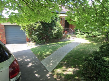
Photograph - 11 Thistle Street, Surrey Hills, The Street Where You Live Project
... 11 Thistle Street, Surrey Hills...The Street Where You Live Project Photograph 11 Thistle Street, Surrey Hills ...Photos documenting this address as part of a photographic series undertaken by volunteer photographers during 2013 and 2014 for The Street Where You Live Project. This was organised through the Surrey Hills Neighbourhood Centre and covered the postcode 3127 in the cities of Boroondara and Whitehorse.These photos provide a snapshot of real estate in the suburbs of Mont Albert and Surrey Hills during a period of rapid change with many properties on large blocks demolished to create higher density residential development or renewal of single dwellings. At particular risk were properties not covered by heritage overlays, in particular interwar housing and post 1950's housing. -
 Surrey Hills Historical Society Collection
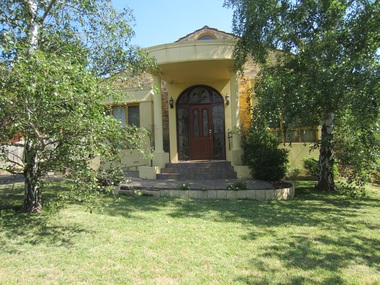
Photograph - 13 Thistle Street, Surrey Hills, The Street Where You Live Project
... 13 Thistle Street, Surrey Hills...The Street Where You Live Project Photograph 13 Thistle Street, Surrey Hills ...Photos documenting this address as part of a photographic series undertaken by volunteer photographers during 2013 and 2014 for The Street Where You Live Project. This was organised through the Surrey Hills Neighbourhood Centre and covered the postcode 3127 in the cities of Boroondara and Whitehorse.These photos provide a snapshot of real estate in the suburbs of Mont Albert and Surrey Hills during a period of rapid change with many properties on large blocks demolished to create higher density residential development or renewal of single dwellings. At particular risk were properties not covered by heritage overlays, in particular interwar housing and post 1950's housing. -
 Bendigo Historical Society Inc.
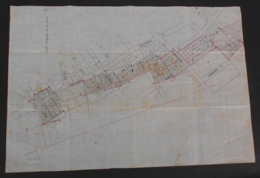
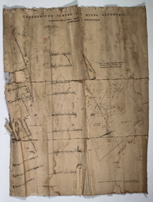
Document - WES HARRY COLLETION: SURVEYORS MAP ON LINEN OF HONEYSUCKLE AND THISTLE STREETS
... ...Thistle Street...A surveyor's map to scale 4 chains to 1 inch of Honeysuckle & Thistle Streets, between Alley Street and Clark Street. ...Wes Harry Surveyors map Honeysuckle street Thistle Street A surveyor's map to scale 4 chains to 1 inch of Honeysuckle & Thistle Streets, between Alley Street and Clark Street. ...A surveyor's map to scale 4 chains to 1 inch of Honeysuckle & Thistle Streets, between Alley Street and Clark Street. Section of map is overlaid in pink. Unknown purpose of the plan - undatedwes harry, surveyors map, honeysuckle street, thistle street -
 Bendigo Historical Society Inc.
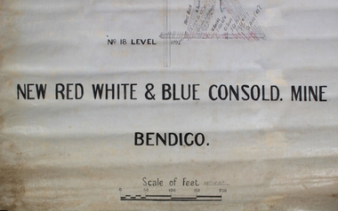
Plan - New Red White and Blue Consolidated Mine, Bendigo, unknown
... ...Thistle Street...The New Red White and Blue Consolidated Gold Mine was located in Golden Square, at the end of Thistle Street....History House 11 Mackenzie Street Bendigo goldfields The New Red White and Blue Consolidated Gold Mine was located in Golden Square, at the end of Thistle Street. Bendigo Mining Thistle Street Hand drawn plan of the New Red White and Blue Consolidated Mine, Bendigo. ...The New Red White and Blue Consolidated Gold Mine was located in Golden Square, at the end of Thistle Street.Hand drawn plan of the New Red White and Blue Consolidated Mine, Bendigo. Plan describes shaft and geological features to Level 18 at 1792 feet, in the mine. Printed on the bottom of the plan in bold capitals: " New Red White & Blue Consold. Mine Bendigo' and 'Scale of Feet, 30 ft = 1 inch'.bendigo, mining, thistle street -
 Surrey Hills Historical Society Collection
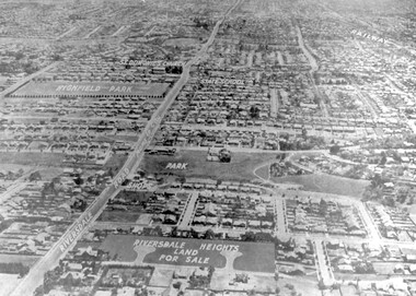
Photograph - Aerial view Riversdale Heights Estate area, c1923
... ...thistle street...Other roads (unmarked) in the foreground are Graham Street, Allie Street, Thistle Street, Lille Street, Amiens Street, and Marne Street. ...Other roads (unmarked) in the foreground are Graham Street, Allie Street, Thistle Street, Lille Street, Amiens Street, and Marne Street. ...This was probably part of a real estate promotion for the sale of the Riversdale Heights Estate. This was subdivided by Messrs. Duncan and Weller. Of the allotments offered, 30 were sold and realised £4600. Date of this sale was c December 1923. This suggests that the date This are was one of the last pieces of former rural land to be sub-divided for housing in Surrey Hills.The land between it and South Surrey Park was sub-divided post WW1, hence the naming of the streets after sites of WW1 battles.A black and white reproduction of an aerial photo of the area near the corner of Warragul and Riversdale Roads looking west towards the city. Some features have been identified by name including the Riversdale Heights Estate, which was being sub-divided. North and South Courts are shown. Other roads (unmarked) in the foreground are Graham Street, Allie Street, Thistle Street, Lille Street, Amiens Street, and Marne Street. Beyond these is the area marked 'PARK' (South Surrey Park), which is devoid of vegetation. Areas of Camberwell and Canterbury are also shown. The area covered extends to beyond St Dominic's Church. The original is mounted on a cream deckle-edged paper.Beneath the original on the mount: "SOUTH SURREY HILLS LOOKING WEST c. 1936" [The reference to the sale in the Box Hill Reporter of December 1923 found on Trove suggests that this date is not accurate.] Rear top LH corner of original in Jocelyn Hall's handwriting: "For Centre / from Mr James Long"riversdale heights estate, riversdale road, allie street, south surrey park, lille street, thistle street, amiens street, marne street, south court, north court, duncan and weller, real estate sales, graham street, st dominics church, highfield park, canterbury primary school, aerial photo -
 Bendigo Historical Society Inc.
Book - THE SCHOOL PAPER: CLASSES VII AND VIII, 1914
... ...Thistle Street...History House 11 Mackenzie Street Bendigo goldfields BENDIGO Education Thistle Street Bendigo The School Paper (Classes VII and VIII); 1914 - 12 copies. ...The School Paper (Classes VII and VIII); 1914 - 12 copies. Copies re hand-stitched into the covers of an exercise book with the normal pages removed. Initials ‘‘D.M.'' are handwritten in ink on front of some copies; inside front cover a name has been erased (address us Thistle St, Bendigo with a date of 1911).bendigo, education, thistle street, bendigo -
 Surrey Hills Historical Society Collection
Folder of real estate advertisements, Folders of real estate advertisements (Streets beginning with T), Various
... ...thistle street...Surrey Hills Historical Society Collection 190A Canterbury Road Canterbury melbourne tevelton lane thames street the avenue theodore street thistle street thornton avenue tower street trafalgar street tyndall street A4 folders with individual pockets for each property in streets beginning with T located in Surrey Hills and Mont Albert. ...A4 folders with individual pockets for each property in streets beginning with T located in Surrey Hills and Mont Albert. Folders are ordered by street name and then chronologically by property number. Each property has its own pocket. This may include multiple real estate advertisements collected from sales over time. It may also include copies of any research undertaken by Alan Holt and / or members of the SHNCHC team. These are augmented by cards in the Alan Holt index file and by his property registers of Surrey Hills and Mont Albert.tevelton lane, thames street, the avenue, theodore street, thistle street, thornton avenue, tower street, trafalgar street, tyndall street -
 Bendigo Historical Society Inc.
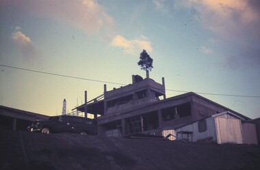
Slide - BENDIGO & EASTER FAIR, 1970
... Corners of Lily, Barnard and Thistle streets, Bendigo....Corners of Lily, Barnard and Thistle streets, Bendigo. Slide BENDIGO & EASTER FAIR ...Mount Alvernia Hospital under construction, note tree on top. Corners of Lily, Barnard and Thistle streets, Bendigo.slide, bendigo, mount alvernia hospital, mount alvernia hospital, bendigo -
 Bendigo Historical Society Inc.
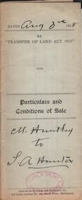
Document - H.A. & S.R. WILKINSON COLLECTION: CONDITION OF SALE
... Hunter for land at the corner of Creek and Thistle Streets, Bendigo held under miners right No. 6128 and being residence area No. 18124 for the price of 16 pounds and 10 shillings...Hunter for land at the corner of Creek and Thistle Streets, Bendigo held under miners right No. 6128 and being residence area No. 18124 for the price of 16 pounds and 10 shillings Document H.A. & S.R. ...BHS CollectionParticulars and conditions of sale dated 3rd. August, 1928 between M. Huntley and S. A. Hunter for land at the corner of Creek and Thistle Streets, Bendigo held under miners right No. 6128 and being residence area No. 18124 for the price of 16 pounds and 10 shillingsorganization, business, h.a. & s.r wilkinson real estate -
 Bendigo Historical Society Inc.
Plan - Shenandoah and North Shenandoah mines
... The North Shenandoah Gold Mine was located in Panton Street, Golden Square, approx. 300m from the corner of Thistle Street. ...The North Shenandoah Gold Mine was located in Panton Street, Golden Square, approx. 300m from the corner of Thistle Street. Margaret Roberts gold gold mine Bendigo Shenandoah and North Shenandoah High Street Panton Street Golden Square Drawn on light tan paper, printed on top of plan: "Underground survey of mines, Sandhurst. ...The Shenandoah Gold Mine was located in High Street, opposite the (then) Fire Station in Golden Square. The North Shenandoah Gold Mine was located in Panton Street, Golden Square, approx. 300m from the corner of Thistle Street. Drawn on light tan paper, printed on top of plan: "Underground survey of mines, Sandhurst. Shenandoah and North Shenandoah'. Plan shows shafts and levels. Printed on bottom of plan: 'Surveyed by E.T. Brown under the direction of the Secretary of the Mines , Mining Department, June 1890' Plan forms part of the Margaret Roberts Collection of mining records. margaret roberts, gold, gold mine, bendigo, shenandoah and north shenandoah, high street, panton street, golden square -
 Bendigo Historical Society Inc.
Document - H.A. & S.R. WILKINSON COLLECTION: CONDITION OF SALE
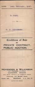
... Wilkinson for land situate in Thistle Street, Bendigo area No. 30459 together with workshop, wash house, stable, bath, copper and wash tube for the price of 7 pounds and 10 shillings...Wilkinson for land situate in Thistle Street, Bendigo area No. 30459 together with workshop, wash house, stable, bath, copper and wash tube for the price of 7 pounds and 10 shillings Document H.A. & S.R. ...BHS CollectionConditions of sale by private contract dated 14th. February, 1928 between F. Ford and G. J. Wilkinson for land situate in Thistle Street, Bendigo area No. 30459 together with workshop, wash house, stable, bath, copper and wash tube for the price of 7 pounds and 10 shillingsorganization, business, h.a. & s.r wilkinson real estate -
 Bendigo Historical Society Inc.
Document - H.A. & S.R. WILKINSON COLLECTION: CONTRACT OF SALE
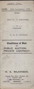
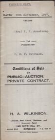
... Skilbeck (buyer) for land situate 106 Thistle Street, Bendigo being part of Crown allotment 14 section 16B described in certificate of title volume 4386 folio 877150, together with 4-roomed weatherboard dwelling and all sundry. ...Skilbeck (buyer) for land situate 106 Thistle Street, Bendigo being part of Crown allotment 14 section 16B described in certificate of title volume 4386 folio 877150, together with 4-roomed weatherboard dwelling and all sundry. ...This business was owned by father and son, Henry Archibald Wilkinson and Samuel Ronald "Ron" Wilkinson. Henry (1882-1954) was born in Shepparton and died in Bendigo. He was married to Grace Hovendon in 1908. Samuel Ronald "Ron" (1914-1995), Henry's son, was married to Florence Jean McKerlie in 1937.Conditions of sale by private contract dated 13th September, 1937 between Mrs. F.P. Armstrong (seller) and C.M.F. Skilbeck (buyer) for land situate 106 Thistle Street, Bendigo being part of Crown allotment 14 section 16B described in certificate of title volume 4386 folio 877150, together with 4-roomed weatherboard dwelling and all sundry. Price 300 pounds. Office copy.organization, business, h.a. & s.r wilkinson real estate -
 Bendigo Historical Society Inc.
Document - H.A. & S.R. WILKINSON COLLECTION: CONTRACT OF SALE
... Skilbeck (buyer) for land situate 106 Thistle Street, Bendigo being part of Crown allotment 14 section 16B described in certificate of title volume 4386 folio 877150, together with 4-roomed weatherboard dwelling and all sundry. ...Skilbeck (buyer) for land situate 106 Thistle Street, Bendigo being part of Crown allotment 14 section 16B described in certificate of title volume 4386 folio 877150, together with 4-roomed weatherboard dwelling and all sundry. ...This business was owned by father and son, Henry Archibald Wilkinson and Samuel Ronald "Ron" Wilkinson. Henry (1882-1954) was born in Shepparton and died in Bendigo. He was married to Grace Hovendon in 1908. Samuel Ronald "Ron" (1914-1995), Henry's son, was married to Florence Jean McKerlie in 1937.Conditions of sale by private contract dated 13th September, 1937 between Mrs. F.P. Armstrong (seller) and C.M.F. Skilbeck (buyer) for land situate 106 Thistle Street, Bendigo being part of Crown allotment 14 section 16B described in certificate of title volume 4386 folio 877150, together with 4-roomed weatherboard dwelling and all sundry. Price 300 pounds. Vendor's copy.organization, business, h.a. & s.r wilkinson real estate -
 Bendigo Historical Society Inc.
Document - H. A. & S. R. WILKINSON COLLECTION: CONTRACT OF SALE
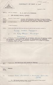
... Property: land being allotment 15 section 17B Parish of Sandhurst city of Bendigo, containing 34 perches situated 60 thistle Street referred in right to occupy a residence area no. 006, together with all buildings thereon. ...Property: land being allotment 15 section 17B Parish of Sandhurst city of Bendigo, containing 34 perches situated 60 thistle Street referred in right to occupy a residence area no. 006, together with all buildings thereon. ...Contract of sale of land dated 19th September 1956 between Farmers and Citizens trustees Company Bendigo administrators of the estate of Edith Maud Burrows deceased (vendor) and Mr. G. W. Symons (purchaser). Property: land being allotment 15 section 17B Parish of Sandhurst city of Bendigo, containing 34 perches situated 60 thistle Street referred in right to occupy a residence area no. 006, together with all buildings thereon. Price: 520 pounds.organization, business, h.a. & s.r wilkinson real estate -
 Bendigo Historical Society Inc.
Document - ALBERT RICHARDSON COLLECTION: NEW RED, WHITE AND BLUE CONSOLIDATED MINE, GOLDEN SQUARE
... The New Red White and Blue Mine, Sheepshead line of reef, was located in Thistle Street, Golden Square. It was also known as the 'Big Blue'. ...History House 11 Mackenzie Street Bendigo goldfields The New Red White and Blue Mine, Sheepshead line of reef, was located in Thistle Street, Golden Square. It was also known as the 'Big Blue'. ...The New Red White and Blue Mine, Sheepshead line of reef, was located in Thistle Street, Golden Square. It was also known as the 'Big Blue'. The mine was formed in 1888, by the amalgamation of the Union and New Red White and Blue. The area of the claim was 32 acres; 781 yards along the line of reef. The main shaft was one of the largest on the field. It had a tall set of steel poppet legs, with a big slope at the front. High landing brace connected to crushing battery close to engine house. The main shaft was the original 'Union" (Albert Richardson notes) and the No. 3 shaft the old New Red White and Blue. Two-page document plus map showing location of the New Red, White and Blue Consolidated mine on the Sheepshead Line of Reef. Information on the mine is given in the following areas: location plant, early history, its role as a leading mine, its prominence, its closure, gold production. References are provided. Document forms part of research referred to in Albert Richardson's paper 2264.70.bendigo, mining, new red white and blue mine