Showing 34 items matching "timber clearing"
-
 University of Melbourne, Burnley Campus Archives
Document, Clearing of timber from farm lands, 1957
... Clearing of timber from farm lands...timber clearing...University of Melbourne, Burnley Campus Archives 500 Yarra Boulevard Richmond melbourne timber clearing fam lands k.v.m. ferguson f.r. drake Reprint of article by K.V.M. ...Reprint of article by K.V.M. Ferguson & F.R. Drake from Journal of Dept. of Agriculture, March 1957 timber clearing, fam lands, k.v.m. ferguson, f.r. drake -
Alexandra Timber Tramway & Museum
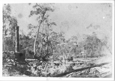
rubicon black and white photo, rubicon power haulage
... Rubicon Black and white photo of power house and hualage at rubicon .Note tin hut on outer edge and timber clearing for power lines. Mr Sapsford of Alexandra...Alexandra Timber Tramway & Museum 17 Station Street Alexandra high-country Rubicon Power house and haulage Rubicon Black and white photo of power house and hualage at rubicon .Note tin hut on outer edge and timber clearing for power lines. Mr Sapsford of Alexandra rubicon power haulage rubicon black and white photo ...Rubicon Black and white photo of power house and hualage at rubicon .Note tin hut on outer edge and timber clearing for power lines. Mr Sapsford of AlexandraRubicon Power house and haulage -
 Merbein District Historical Society
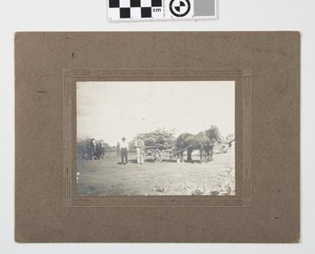
Photograph - Block clearing Merbein, Finnigans Photos Mildura, Clearing the block
... horses blocks clearing timber Merbein...Merbein District Historical Society 36 Box St Merbein the-murray horses blocks clearing timber Merbein Men helpers on the block when clearing M.S. ...Original sepia photograph mounted on cardboardMen helpers on the block when clearing M.S. Finnigans Mildura embossed cardhorses blocks clearing timber merbein -
 Rutherglen Historical Society
Image, Greetings from Rutherglen, 1910 to 1912
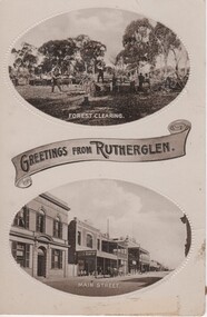
... land clearing...timber...Rutherglen Historical Society Murray Street Rutherglen high-country land clearing timber felling main street bank of australasia s younkman & co victoria hotel At bottom of top photograph: "Forest Clearing." ...Black and white postcard with two oval photographs with "Greetings from Rutherglen" on a banner between them. The top photograph is of workmen cutting down trees. The bottom one is a view of Main Street looking west.At bottom of top photograph: "Forest Clearing." At bottom of bottom photograph: "Main Street."land clearing, timber felling, main street, bank of australasia, s younkman & co, victoria hotel -
 Bendigo Historical Society Inc.
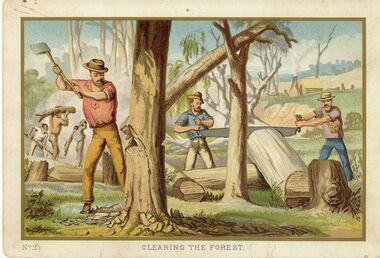
Painting - NO 2 CLEARING THE FOREST
... Card with coloured illustration showing a group of loggers chopping trees and sawing timber titled Clearing The Forest....History House 11 Mackenzie Street Bendigo goldfields ARTWORK Print group unknown Card with coloured illustration showing a group of loggers chopping trees and sawing timber titled Clearing The Forest. Painting NO 2 CLEARING THE FOREST ...Card with coloured illustration showing a group of loggers chopping trees and sawing timber titled Clearing The Forest.unknownartwork, print, group -
 Mont De Lancey
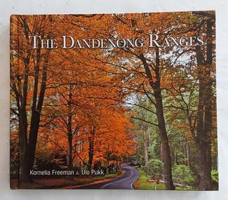
Book, Kornelia Freeman et al, The Dandenong Ranges, 2011
... The Dandenong ranges have a rich history spanning over 35,000 years of indigenous occupation, significant 19th-century timber clearing for Melbourne, and development into a popular 20th-century tourism, residential, and conservation area. ...The Dandenong ranges have a rich history spanning over 35,000 years of indigenous occupation, significant 19th-century timber clearing for Melbourne, and development into a popular 20th-century tourism, residential, and conservation area. ...Tourists come from all over the world to enjoy the prized gardens of Victoria's Dandenong Ranges. This beautifully produced book showcases the splendour of the public and private gardens of the Dandenongs as well as its unique villages and native animals and birds.A colourful covered book showing a road winding through the beautiful autumn trees in the Dandenong Ranges approximately 40km from Melbourne. The title The Dandenong Ranges is printed in white lettering at the top with the two authors listed below. The spine has the title, authors and M symbol for Melbourne Publishers. The title page has the same information with Portraits of Victoria added at the bottom right. There is a Contents, Introduction and then in alphabetical order, stunning photographs and detailed information about each place included. Mont De Lancey Historical Homestead is featured on p.144. At the back is an Acknowlegments list. Pp. 151.non-fictionTourists come from all over the world to enjoy the prized gardens of Victoria's Dandenong Ranges. This beautifully produced book showcases the splendour of the public and private gardens of the Dandenongs as well as its unique villages and native animals and birds.dandenong ranges - victoria, dandenong ranges - history, tourism victoria -
 Greensborough Historical Society
Slide - Photograph, John Ramsdale, Headwaters of the Plenty River: Slide 85, 1990s
... This the headwaters of the Plenty River and clearing of timber can cause problems such as erosion....This the headwaters of the Plenty River and clearing of timber can cause problems such as erosion. ...Photograph shows fallen trees with road in background. This the headwaters of the Plenty River and clearing of timber can cause problems such as erosion.Part of the John Ramsdale collection of slides and audio visual material.Colour photograph scanned from slide.No maker's marks. No caption on slide.plenty river -
 Bendigo Historical Society Inc.
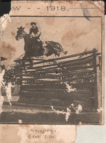
Postcard - POSTCARD: SHOW JUMPING AT BENDIGO AGRICULTURAL SHOW, 1918
... Image shows horse and rider clearing a timber jump , at the Bendigo Agricultural Show, 1918. ...Image shows horse and rider clearing a timber jump , at the Bendigo Agricultural Show, 1918. ...Portion of postcard. Image shows horse and rider clearing a timber jump , at the Bendigo Agricultural Show, 1918. Written on bottom 'Thumbs? clears.... ft'bendigo, sporting clubs, show jumping -
 Stawell Historical Society Inc
Photograph, Town Hall Restoratiion
... Town Hall Renovations 1491-2A: Interior wall of new extension before being built. 1491-2b: Interior wall of new extension after being built. 1491-2c: Timber, Carpet and insulation. 1491-2e: Ladders and timber. 1491-2f: Clearing up before renovations. 1491-2g: Empty room before renovations. 1491-2h: Interiro before renovations. 1491-2i: Main Hall with floor removed....Stawell Historical Society Inc 46 Longfield St Stawell grampians Town Hall Renovations 1491-2A: Interior wall of new extension before being built. 1491-2b: Interior wall of new extension after being built. 1491-2c: Timber, Carpet and insulation. 1491-2e: Ladders and timber. 1491-2f: Clearing up before renovations. 1491-2g: Empty room before renovations. 1491-2h: Interiro before renovations. 1491-2i: Main Hall with floor removed. ...Town Hall Renovations 1491-2A: Interior wall of new extension before being built. 1491-2b: Interior wall of new extension after being built. 1491-2c: Timber, Carpet and insulation. 1491-2e: Ladders and timber. 1491-2f: Clearing up before renovations. 1491-2g: Empty room before renovations. 1491-2h: Interiro before renovations. 1491-2i: Main Hall with floor removed.stawell, town hall renovations -
 Port of Echuca
Coloured Photograph, 04/03/1984
... She has worked in the Wool Industry, the Timber Industry and the Tourist Industry. p.s. adelaide grassie, j.g port of echuca linklater, george poon boon station blair, david murray river darling river logging industry officer brothers. barmah forest fulton & shaw hutchinson, kevin murray downs station blackwood, adelaide On the orange front end loader are the numbers "5900" and the word "case." This is a coloured square photograph of an orange front end loader clearing ...The P.S Adelaide was launched on 21st July 1866. It was owned by J.G.Grassie from Poon Boon Station and the Officer Family of Murray Downs Station Swan Hill. The Adelaide was named after the niece of the Officer Bros, Adelaide Blackwood. The shipwright who built her was George Linklater. The Adelaide brought wool and passengers from the wool stations on the Murray and Darling Rivers down to the Echuca Wharf. In 1872 she was sold to David Blair & Sons. She was used to bring timber from the Barmah Forest to the Echuca Wharf. She did this work for the next 80 years. In 1953 she was tied up near the Mill and left. In 1958 she went to Paringa South Australia to work in the sawmill industry again. In 1960 the Echuca Apex Club and The Echuca Historical Society raised enough funds to buy the P.S. Adelaide and return her to Echuca. In November 1963 she was lifted out of the water and placed in Hopwood Gardens as this was thought to be a way of preserving her. In 1984 it was decided to return her to the water to resume work as a passenger vessel. In that time the Port of Echuca and the Echuca Wharf had been restored as a Tourist Precinct. This photograph shows the beginning of the task to return her to the river. It took several weeks in March 1984.The P.S Adelaide is extremely significant as it it the oldest known wooden hulled paddle steamers in the world. She was built in Echuca in 1866 and still operates on the Murray River today. She has worked in the Wool Industry, the Timber Industry and the Tourist Industry.This is a coloured square photograph of an orange front end loader clearing a track from Hopwood Gardens down to the river. The track was used to bring the P.S Adelaide from the gardens back into the river. The P.S Adelaide is in the background. The paddle steamer appears to be up on a trailer of some sort and is surrounded but plastic orange temporary fencing. There are small mounds of soil in the foreground.On the orange front end loader are the numbers "5900" and the word "case." p.s. adelaide, grassie, j.g, port of echuca, linklater, george, poon boon station, blair, david, murray river, darling river, logging industry, officer brothers., barmah forest, fulton & shaw, hutchinson, kevin, murray downs station, blackwood, adelaide -
 Kiewa Valley Historical Society
Saw Logging, circa early 1900's
... It was used when clearing land for the SEC Hydro scheme and to allow for the introduction of the Mount Beauty construction workers' village (later developed into the town) The great advantage of this saw was that it uses only muscle power and can be located where ever a lumber "Jack" or property owner can venture. either by foot or by horse. one or two man cross cut saws forestry timber industry The central screw has 25mm manufacturers' identification logo stamped "WARRANTED SUPERIOR". ...This item can be seen as a hand piece belonging to a logger or farmer spanning over one hundred or more years. The equipment was made to perfection as a hand tool and has not been improved upon since its introduction into the logging industry or farming fraternity. It can be used by one person or two (husband and wife or father and child). Its versatility is ageless. It can be used for domestic clearing of the paddocks, or for domestic fire places and stoves or commercial logging up until the 2000s (introduction of specific logging trucks that cut and treat the trees in one process).This item is very significant to the rural and logging regions within the Kiewa Valley. It has been used for domestic wood cutting and for industrial logging in the mid to late 1900s. It was used when clearing land for the SEC Hydro scheme and to allow for the introduction of the Mount Beauty construction workers' village (later developed into the town) The great advantage of this saw was that it uses only muscle power and can be located where ever a lumber "Jack" or property owner can venture. either by foot or by horse.This saw is a Warranted Superior One/Two Man Logging Saw. It has 68 teeth and is 42 inches long. At a position of one inch (2.5cm) from the end is a hole one inch down from the leading edge. There is another hole 45 cm in front of the handle. Both these holes are for a "helper handle" which when in use renders this logging saw fit for a two man operation. This is a cross cut saw for cutting down vertical trees (horizontal cut) The handle is made from wood and fastened to the blade by three heavy duty screws. The one helper handle stands 150mm high and has a 150mm wooden hand grip.The central screw has 25mm manufacturers' identification logo stamped "WARRANTED SUPERIOR".one or two man cross cut saws, forestry, timber industry -
 Emerald Museum & Nobelius Heritage Park
Negative - Image of The Railway Line, Baker & Rouse, Early 20th century
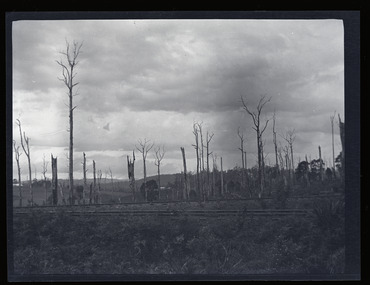
... This stark image of bare landscape with dead trees recalls both the early timber industry in Gembrook and the practice of wide-spread clearing of land for farming use. ...This negative is one of a batch of ten images taken apparently around the same time at Gembrook c. early 20th century. This one is of the Ferntree Gully to Gembrook railway line, which was completed in December 1900. The view looks northwards to the hills from probably present-day Station Road. This stark image of bare landscape with dead trees recalls both the early timber industry in Gembrook and the practice of wide-spread clearing of land for farming use.Black and white negative - landscape view - of the railway line at Gembrook. The railway is in the foreground. The landscape is bare apart from dead and ringbarked trees. Negative has been kept inside a packet which is not original.Handwritten on (not original) packet containing negative: 'Railway line & dead trees /Gembrook'gembrook, timber industry, railway, 1900, early 20th century, station rd -
 Emerald Museum & Nobelius Heritage Park
Photograph - Photograph of Woodcutters c. 1900s, Circa 1900
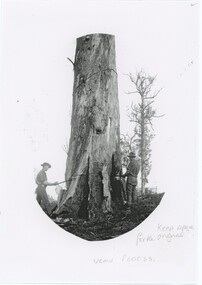
... Tree clearing was one of many important activities in early Emerald, both to collect timber for firewood and construction, and to open space for Nobelius' nursery and other agricultural and residential properties. ...It is difficult to say exactly when and where this photograph was taken. It was most likely around the year 1900, but could have originated from anywhere in the region. One site at which significant tree-clearing occurred at this time was the Nobelius nursery, where many native trees were removed in favour of trees producing fruit and other products of the nursery. It can't be confirmed that this picture was taken there, but it is certainly a possibility.Tree clearing was one of many important activities in early Emerald, both to collect timber for firewood and construction, and to open space for Nobelius' nursery and other agricultural and residential properties.A black and white image of two woodcutters manually sawing through a large tree. A rope is tied further up the tree's trunk to control the direction in which it falls. This is a copy of an earlier original photograph. The photograph fills an oval in the center of the paper.No original markings.tools, forestry -
 Bendigo Military Museum
Photograph - PHOTOGRAPH, FRAMED, Gunner Harry F Midgley, System generated
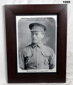
... Clearing Station Belgium 2.8.1917. photography-photographs military history Midgley 3414 Gunner Henry Foster Midgley, Bendigo 11th Field Artillery Brigade on top. Died of wounds - 02 August 1917 at bottom. On back: Brenda Chambers in texta. Black & white photocopied photograph of soldier, button up uniform from waist up with Rising Sun badges on lapels. Peeked cap with badge in front, faux timber ...Harry Foster Midgley No 3414 enlisted in the AIF in 11th reinforcements 14 th Batt on 14.7.1915 aged 21 years 4 months. Embarked for Egypt 11.10.1915, hospitalised 14.12.1915 with Dysentry, returned to unit 4.2.1916, transferred to 46th Batt 3.3.1916 then 12th FAB as a gunner 17.3.1916. Embarked for France 2.6.1916, transferred to 11th FAB, WIA GSW to left ear, transferred to 4th Div Ammunition column 25.6.1917, WIA 1.8.1917 with GSW’s to chest, back, right arm, right leg. DOW’s in 41st Casualty Clearing Station Belgium 2.8.1917.Black & white photocopied photograph of soldier, button up uniform from waist up with Rising Sun badges on lapels. Peeked cap with badge in front, faux timber frame with glass front, cardboard back. 3414 Gunner Henry Foster Midgley, Bendigo 11th Field Artillery Brigade on top. Died of wounds - 02 August 1917 at bottom. On back: Brenda Chambers in texta.photography-photographs, military history, midgley -
 Eltham District Historical Society Inc
Photograph, Fay Bridge, Former Glynn's Dairy Farm, Glynns Road, North Warrandyte, 31 August 2018
... clearing the land during WW2 selling wood. Prior to marriage, Kenneth was living alone on the farm in a house he had built from whatever was available. He used the bluestone foundations from the original fine brick home. He met and married Honora Elizabeth Drew in early 1945 and their daughter Anna grew up on the farm. It was compulsorily acquired by the Board of Works in 1976 who then rented the house out in the 1980s. The property was transferred to Melbourne Parks and Waterways in 1996. Waikowhane was a pretty timber...clearing the land during WW2 selling wood. Prior to marriage, Kenneth was living alone on the farm in a house he had built from whatever was available. He used the bluestone foundations from the original fine brick home. He met and married Honora Elizabeth Drew in early 1945 and their daughter Anna grew up on the farm. It was compulsorily acquired by the Board of Works in 1976 who then rented the house out in the 1980s. The property was transferred to Melbourne Parks and Waterways in 1996. Waikowhane was a pretty timber ...Glynn’s farm Originally Section 7, Parish of Nillumbik marked Aborigine Reserve in 1866 Crown Allotment 8, Section 7, Parish of Nillumbik, County of Evelyn, Certificate of Title Volume 4095, Folio 818.835, approx. 93 acres purchased by Joseph Panton in 1881 for £1/acre and known as Panton’s Point. By 1924 owned by S.S. Sergeant and called Riverswood. Sergeant commissioned Edna Walling to design the garden. In September 1929 the property was sold at auction by Mortgagee’s sale. Described as well built, brick, tile roof, Attic Villa containing downstairs 7 good rooms, bath, scullery, inside lavatory, etc. Upstairs 2 bedrooms and sleep out. Outbuildings compromising of brick and weatherboard wash house, stables, workshop, feed room, cow bails, large G.I. Hay shed, etc In January 1931 Riverswood property was proclaimed a sanctuary for native game for the entire year. A private swing bridge crossed the river at Pound Bend was known as Pearson’s bridge after C.W.K. Pearson who bought Riverswood in the early 1930s. The bridge was swept away in the December 1934 floods. Riverswood was sold by C.W.K. Pearson at auction on 25 November 1936. Described as a beautiful farm home of 93 acres and over one mile of River Yarra frontage, modern brick residence, lovely garden, rich river flat pastures, model poultry farm. The fine brick home was destroyed on Black Friday (13 Jan.) 1939. It was still a ruin when the Evelyn Evans purchased Waikowhane above Riverswood in 1940. The Glynn family purchased the Riverswood property in 1941 from Robert and Emily Hannon. Their son Kenneth Patrick Glynn inherited the property and he set about clearing the land during WW2 selling wood. Prior to marriage, Kenneth was living alone on the farm in a house he had built from whatever was available. He used the bluestone foundations from the original fine brick home. He met and married Honora Elizabeth Drew in early 1945 and their daughter Anna grew up on the farm. It was compulsorily acquired by the Board of Works in 1976 who then rented the house out in the 1980s. The property was transferred to Melbourne Parks and Waterways in 1996. Waikowhane was a pretty timber house built on top of the hill on 50 acres above Riverswood by retired nurse Jessie MacBeth. (This would be at the intersection of Glynns Road and Overbank Road where the big water tank is now situated on what was once James Orford’s property.) It was also destroyed Black Friday and she rebuilt it from the plans living in a caravan on site supervising the build. It was almost complete when she died May 1939. The property was bought by Evelyn Evans (a city girl) and her estranged husband in 1940. She had two sons, one only 9 months old at the time. It was a timber house with no power or water connected. The Ewen Cameron family bought Waikowhane in 1957. They had to evacuate when the 1961 bushfires swept through. The house was saved by Matcham Skipper. It was demolished by Melbourne Water in the 1990s when they acquired it.fay bridge collection, 2018-08-31, glynn's, glynn's dairy farm, glynns road, north warrandyte, parks victoria, ruins, riverswood, kenneth patrick glynn -
 Eltham District Historical Society Inc
Photograph - Digital Photograph, Alan King, Kinglake National Park, 27 March 2008
... However, before long, the accessible timber supply ran out, so in the 1920s agriculture took over – particularly potatoes and berry fruits – which involved large-scale clearing.2 The park’s instigator was retired Melbourne University Professor of Music, William Laver.3 As chair of the Kinglake Progress Association he began negotiations to have crown lands on the southern scarp of the Great Dividing Range reserved as a national park. ...However, before long, the accessible timber supply ran out, so in the 1920s agriculture took over – particularly potatoes and berry fruits – which involved large-scale clearing.2 The park’s instigator was retired Melbourne University Professor of Music, William Laver.3 As chair of the Kinglake Progress Association he began negotiations to have crown lands on the southern scarp of the Great Dividing Range reserved as a national park. ...Fern gullies around Jehosaphat Gully Covered under National Estate. Published: Nillumbik Now and Then / Marguerite Marshall 2008; photographs Alan King with Marguerite Marshall.; p125 The magnificent Kinglake National Park, fringing Nillumbik’s north, is the largest national park close to Melbourne. Thanks to the vision and hard work of a band of local people, the park was created from what was rapidly becoming degraded land. Seeing a threat to Kinglake’s indigenous flora and fauna, several prominent local people campaigned for a national park, which was established in 1928.1 Since then, the park has grown through donations and acquisitions of land, from around 13,800 acres of land (5585ha) to 22,360 hectares. The Sugarloaf and Everard Blocks – of almost 8000 hectares – stand in Nillumbik and the park extends into Mitchell and Murrundindi Shires and the City of Whittlesea. Mt Everard commemorates William Hugh Everard, State member for Evelyn when the park was established. Before 1928, European settlers had degraded the Kinglake area, which was named after the celebrated English author and lawyer, Alexander William Kinglake. Remains of gold shafts and diggings in the park are reminders of Kinglake’s first settlers, who hoped to strike it rich at the gold diggings. But like other gold fields in this shire, they proved not very lucrative and soon timber cutting replaced mining in importance. However, before long, the accessible timber supply ran out, so in the 1920s agriculture took over – particularly potatoes and berry fruits – which involved large-scale clearing.2 The park’s instigator was retired Melbourne University Professor of Music, William Laver.3 As chair of the Kinglake Progress Association he began negotiations to have crown lands on the southern scarp of the Great Dividing Range reserved as a national park. Even before the park was proclaimed, from 1927, KPA members cut tracks to the major scenic points. Professor Laver was one of several people who gave land for the park, donating around 50 acres (20ha), including the Jehosaphat Gully.4 Laver chaired the park’s first Committee of Management, which raised money to employ a ranger and provide facilities, including tracks and roads for fire protection vehicles, toilets and shelters. The committee charged fees for firewood collection, some grazing of livestock, and visitor entrance, and obtained small State Government and Eltham Shire grants. In 1957 the State Government provided revenue for national parks. Then, in 1975, the State Government took over the management and the Committee of Management became an advisory committee, which disbanded in 1978. Originally, the park covered crown land in the Shires of Eltham and Whittlesea; then Wombelano Falls in Yea and other areas were added. In 1970 the park extended into the Shires of Eltham, Healesville, Whittlesea and Yea.5 Bush fires have been an ongoing problem. In 1939 hundreds of eucalypts and acacias had to be sown around the Jehosaphat Gully to rejuvenate the forest. To manage bushfires, the Committee of Management, then the State Government, worked closely with the Forestry Commission, shire councils and local fire brigades. Early national parks focussed on recreation. But by the 1980s, conservation, education and scientific research became more important, playing a vital role in preserving representative samples of the natural environment. Each year many thousands of people use the park’s extensive network of walking tracks amongst the protected plant and animal life as well as camping, cycling and horse riding. The park, along the slopes of the Great Dividing Range, has lookouts revealing magnificent views of the Melbourne skyline, Port Phillip Bay, the Yarra Valley and the You Yangs. Vegetation in the Masons Falls area includes messmate forest, Austral grass-trees, ferns and Hazel Pomaderris. In spring, orchids, lilies, everlasting daisies, correas, grevillea and heath appear. Around Jehosaphat Gully are wet and dry forest, fern gullies and banksia. Animal life includes wallabies, kangaroos, koalas, echidnas, possums, gliders and bandicoots. Male lyrebirds can be heard mimicking in the Jehosaphat Gully, particularly in the Everard Block in winter.This collection of almost 130 photos about places and people within the Shire of Nillumbik, an urban and rural municipality in Melbourne's north, contributes to an understanding of the history of the Shire. Published in 2008 immediately prior to the Black Saturday bushfires of February 7, 2009, it documents sites that were impacted, and in some cases destroyed by the fires. It includes photographs taken especially for the publication, creating a unique time capsule representing the Shire in the early 21st century. It remains the most recent comprehenesive publication devoted to the Shire's history connecting local residents to the past. nillumbik now and then (marshall-king) collection, kinglake national park, jehosaphat gully -
 Halls Gap & Grampians Historical Society
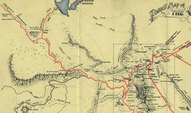
Map - Coloured
... timber to Pleasant Creek living in the "Hall's Gap ranges". John Wakeham, the first store owner in Pleasant Creek in 1854, established a timer-mill in upper Stony Creek Gorge in the late 1850s. Wakeham is credited for the clearing...timber to Pleasant Creek living in the "Hall's Gap ranges". John Wakeham, the first store owner in Pleasant Creek in 1854, established a timer-mill in upper Stony Creek Gorge in the late 1850s. Wakeham is credited for the clearing ...Background on Bridle Path up Stony Creek Gorge Pre 1840 C. B. Hall, squatter on Mokepilly Run 1841-1842, first European to discover the Fyans Creek valley, the entrance of which became known as Hall's Gap. He later recorded that he followed a number of tracks which he assumed had been made by the Aboriginies and described one as "leading up a wild romantic glen and over on to the source of the Glenelg River". This could well have been the route taken up Stony Creek gorge by the first timber-cutters in this part of the Grampians to the saddle between the Wonderland and Mt. Difficult ranges known as Valley Gap 1850s/60s Timber cutters and shingle splitters were reported to be moving into the eastern side of the Grampians and by the mid 1860s there were a number of families connected to the supplying of timber to Pleasant Creek living in the "Hall's Gap ranges". John Wakeham, the first store owner in Pleasant Creek in 1854, established a timer-mill in upper Stony Creek Gorge in the late 1850s. Wakeham is credited for the clearing and levelling of the first bridle-path up the gorge. 1870s By the mid 1870s the track had been extended over Valley Gap to the Victoria Forest (the upper region of the Victoria Valley). McKeon's bullock team was known to have hauled red gum from the Valley to Stawell in the late 1870s and the 1880s. 1880s In 1887 an article in the Pleasant Creek news describes the Stony Creek Gorge track as "being a ledge alongside the mountain range, formed in the early days with the aid of earth and timber, along which the bullock teams used to travel to Horsham and plains of the Wimmera beyond." 1890s Gold was discovered in the catchment area of Stony Creek and by the end of the 1890s a new track was built from "near the junction of Fyan's and Stony Creeks, up the gorge to the diggings settlement. The mining Department had paid L300 for its construction and, when completed, the track was "three miles and 30 chains in length, the side cuttings at the narrowest part being 10 feet between" and "the watercourses which cross the track at various points" having been "filled up with rocks rolled down the sides of the hills, and consequently there can be no damage caused by bushfires which destroyed the former wooden bridges erected on the old track to Wakeham's saw-mill, the remains of which are still to be seen at the side of the diggings" The article goes on to further describe the track as one which "can with ease travel with a two horse conveyance either up or down" and that the workmen engaged in the construction of the track would be attending "a ball that night at McKeon's farm near the mouth of the gap to celebrate the successful completion of the undertaking". 1900s At what time the bridle path was extended beyond Valley Gap to the Wartook basin on the Mt. Difficult Range has not yet been determined. However, it is known that, by the turn of the century, people were travelling between Halls Gap and the caretakers' residence at Wartook Reservoir along what was now known as the "Bluff Road. Wartook's embankment had been constructed in 1887 and at that time there was already a track from Rosebrook Station homestead (near the present day Wartook Pottery) to the reservoir. Philip Rose owned both Rosebrook and Wartook Stations from the mid 1840s to the late 1850s and had regularly leased the Wartook basin to Cobb & Co. to rest horses there. 1920s Following the war of 1914-1918, tourism really took off in the Grampians, and Halls Gap rapidly grew. People would travel as far as they could on the many tracks then hike to the many lookouts being discovered by local tour guides. This led to the need for access across the range so that horse riders and the increasing number of vehicles could travel between Horsham and Halls Gap. To this end, the Bluff Road was improved and extended on 1929 and at its opening in March, 1930, by Lady Somers it was renamed the Mt. Victory Road.Map of Mt Victory Road and othersaccess routes, mt victory rd, bridle path, roads -
 Halls Gap & Grampians Historical Society
Photograph - B/W, C 1900s
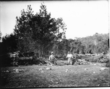
... TIMBER INDUSTRIES Wattlebark stripping SCENERY Roses Gap The photo shows two men kneeling in a clearing. ...Wattle-bark stripping (bundling) at Roses Gap. The identity of the men is unknown.The photo shows two men kneeling in a clearing. They are both working on pieces of wattle bark and have piles of bark around them. There is thick bush behind the clearing.timber industries, wattlebark stripping, scenery, roses gap -
 Halls Gap & Grampians Historical Society
Photograph - B/W
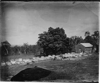
... The photos show a group of bee-hives lined up in front of a timber shed. The hives and shed are in a clearing. There is a large tree near the shed and the clearing is edged with thick bush in the background. ...MISC INDUSTRIES Bee-keeping SCENERY Cherrypool The photos show a group of bee-hives lined up in front of a timber shed. The hives and shed are in a clearing. There is a large tree near the shed and the clearing is edged with thick bush in the background. ...The photos show the Russell bee-hives at Roses Gap. The tree near the hut is the present site of Chinaman Lodge home. One of the copies is a transparency located at No 243 in the slide box.The photos show a group of bee-hives lined up in front of a timber shed. The hives and shed are in a clearing. There is a large tree near the shed and the clearing is edged with thick bush in the background. The two copies are of two photos taken at slightly different angles and distances from the shed.misc industries, bee-keeping, scenery, cherrypool -
 Halls Gap & Grampians Historical Society
Photograph - B/W, C 1910
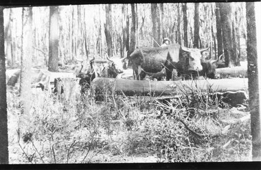
... TIMBER INDUSTRIES Logging TRANSPORT Bullock team The photo shows a team of bullocks surrounded by logs in a clearing in the bush. ...The photo is of an unknown bullock team in the Grampians. Note: The photo may have been taken by Guy E. Neate of "Rosebank" on Neates Road in the Victoria Valley, however Guy Neate did not buy that property until June 1926 (see the book "Water Between the Hills".The photo shows a team of bullocks surrounded by logs in a clearing in the bush. A man is just visible behind the bullocks.timber industries, logging, transport, bullock team -
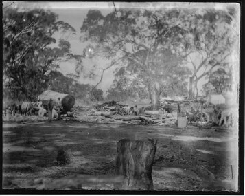
 Halls Gap & Grampians Historical Society
Photograph - B/W
... TIMBER INDUSTRIES Logging Sawmilling The photo shows a clearing with the remains of an old building and steam engine on the front left. ...The photo shows the site and remains of John Child's Glenbower Mill (which operated in the mid-1800's).The photo shows a clearing with the remains of an old building and steam engine on the front left. A small hut can be seen at the back of the clearing, to the right of centretimber industries, logging, sawmilling -
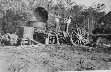
 Halls Gap & Grampians Historical Society
Photograph
... Halls Gap & Grampians Historical Society Centennial Hall 117-119 Grampians Road Halls Gap grampians A temporary saw-mill in the central Grampians. timber industries logging sawmilling Photo shows a clearing containing a saw mill. ...A temporary saw-mill in the central Grampians.Photo shows a clearing containing a saw mill. There is a saw with traction engine to the right ands a bullock wagon containing a large log to the left. There is a man to the right working with the engine, four men among the wood in the centre and two men near the wagon on the left. A large wood stump is prominent in the foreground. timber industries, logging, sawmilling -
 Halls Gap & Grampians Historical Society
Photograph - B/W, C 1919-1920
... TIMBER INDUSTRIES Charcoal Burning The photo shows two men standing on a platform feeding wood into a large charcoal burner.To the right there is a wagon (from which they are getting the wood) with a horse hitched to it (only the rear part of the horse is visible). To the left are full sacks. There is bush in the background and a rutted clearing ...Burning charcoal for the Ararat Gas Company. The location is unknown.The photo shows two men standing on a platform feeding wood into a large charcoal burner.To the right there is a wagon (from which they are getting the wood) with a horse hitched to it (only the rear part of the horse is visible). To the left are full sacks. There is bush in the background and a rutted clearing in the foreground.timber industries, charcoal burning -
 Bendigo Historical Society Inc.
Slide - DIGGERS & MINING. LIFE OF THE SELECTORS, c1880
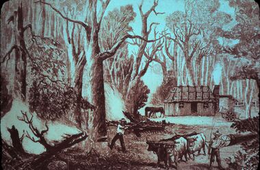
... One man is using the cattle to pull timber, the other is using an axe to chop a large tree down. Markings; Life Of The Selectors 1860-1890 Set 432 No.9. Selectors Clearing...One man is using the cattle to pull timber, the other is using an axe to chop a large tree down. Markings; Life Of The Selectors 1860-1890 Set 432 No.9. Selectors Clearing ...BHS CollectionDiggers & mining. Life Of The Selectors. 2 men, 4 cattle, 2 horses, timber hut with out building, and a cart sitting nearby. There has been a timber fence constructed behind the buildings. One man is using the cattle to pull timber, the other is using an axe to chop a large tree down. Markings; Life Of The Selectors 1860-1890 Set 432 No.9. Selectors Clearing the Forest - ''The Australasian Sketcher,'' Jan. 31, 1880. Used as a teaching aid.Visual Education Centreeducation, tertiary, goldfields -
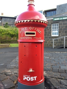 Flagstaff Hill Maritime Museum and Village
Functional object - Post Office Receiving Pillar, 1885
... timber, then someone to manufacture it. The cast iron body required sand blasting and undercoating. The pillar was installed in Flagstaff Hill Maritime Village in March 2014. A specialist visited the Village and painted the pillar with 7 coats of ‘post office red’ then completed the job with gold paint on the details. In 2015 an information plate of brass was fitted to the Pillar in the position that would have originally announced the clearing...timber, then someone to manufacture it. The cast iron body required sand blasting and undercoating. The pillar was installed in Flagstaff Hill Maritime Village in March 2014. A specialist visited the Village and painted the pillar with 7 coats of ‘post office red’ then completed the job with gold paint on the details. In 2015 an information plate of brass was fitted to the Pillar in the position that would have originally announced the clearing ...Post Office Receiving Pillar was Collected from Warrnambool City Council’s Scott Street Depot and transported to Flagstaff Hill, stored in the Barracks area Friends of Flagstaff Hill began the project of restoring the Post Office Receiving Pillar in early 2011. The replacement dome required a pattern to be made from paper, then timber, then someone to manufacture it. The cast iron body required sand blasting and undercoating. The pillar was installed in Flagstaff Hill Maritime Village in March 2014. A specialist visited the Village and painted the pillar with 7 coats of ‘post office red’ then completed the job with gold paint on the details. In 2015 an information plate of brass was fitted to the Pillar in the position that would have originally announced the clearing times. It was originally manufactured by G Couch, Engineer, Alliance Iron Works, Melbourne. Gordon Couch passed away in June 1896 and his Works were offered for auction in November 1897. HISTORY OF POST OFFICE RECEIVING PILLARS In 1851 ‘pillar boxes’ were installed at roadside locations in the island of Jersey, England; they had already been successful in several European countries. The use of new prepaid, adhesive postage stamps as well as the roadside pillar boxes meant there was no need for the public to take a trip to the Post Office just to post a letter. By 1855 London had installed its first six Pillar Boxes. In 1856 the pillar boxes were first introduced in Sydney. These were circular with a crown on the dome, supported by leaves. Early Victoria Mail was originally collected by ‘letter carriers’, first appointed in Melbourne in 1841, equipped with leather bag and hand bell. He wore a red coat with brass buttons and a black top hat! In 1844 two wooden receiving boxes were erected in Melbourne. The first cast iron boxes were installed in South Melbourne (Emerald Hill) and were still in service until 1967. They were a fluted circular design and made in England. In the early 1860’s the ‘low door round’ design posting box was introduced, being circular and surrounded by a crown, with two broad embossed bands around its circumference. The clearance door was in front of the box and low down. These were made in Australia. In the early 1870’s square boxes with a tapering top were being used. These too were made in Australia by different manufacturers with slight variations on style such as the orientation and number of slots. Next came the circular boxes again, similar to the ‘low door round’ but with the clearance door extending to just below the posting slot, often referred to as ‘high door round’. These boxes did not have embossed bands. In 1887 small cast iron boxes were introduced, attached to posts and poles and called ‘lamp post receivers’. Around 1930 a ‘London’ model was used in Victoria. It was copied from the flat-domed type in London but made in Tasmania. … [References: Flagstaff Hill Maritime Village records, The Argus, 11th April, 1890, The Argus, 2nd July, 1896, The Argus, 30th Nov. 1897, “Stamps.Au” http://www.stampsau.com, 4th April 2011 (Extracted from “Australian Street Posting Boxes” by Ken Sparks – out of print)] Post Office Receiving Pillar, or letterbox.1885 "High Door Round" design, restored 2014 Tall cast iron sylinder with decorative dome cap, slot in side, hinged door with handle shaped as a fist. Painted red with gold trip..Reconditioned barrel, reconstructed dome. Restored by Friends of Flagstaff Hill, 2014. Now a working letterbox. Made in Melbourne.Oval maker's plate “ - G. COUCH - / ENGINEER / ALLIANCE IRON / WORKS / MELBOURNE”flagstaff hill, warrnambool, shipwrecked coast, flagstaff hill maritime museum, maritime museum, shipwreck coast, flagstaff hill maritime village, great ocean road, post office receiving pillar, letterbox, mailbox, australia post -
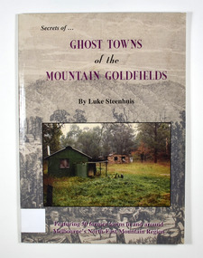 Marysville & District Historical Society
Book - Paperback book, Ghost Towns of the Mountain Goldfields, 1999
... In the foreground is a green timber building with a water tank and verandah. It is all set in the clearing in the middle of a forest....In the foreground is a green timber building with a water tank and verandah. It is all set in the clearing in the middle of a forest. ...Ghost towns of the mountain goldfields in VictoriaPaperback. Cover has a drawing depicting horses, both ridden and pack, walking along a forest track on their way to a small town. There are heavily forested mountains in the distance. Overlaid onto the drawing is a modern photograph of an old stone building. In the foreground is a green timber building with a water tank and verandah. It is all set in the clearing in the middle of a forest.Stamp of the Marysville & District Historical Society Inc / P.O. Box 22 / Marysville 3779 Also the inscription: To Alma / Thanks for your help / Signature / LS / November 1999gold, gold mining, gold town, ghost town, victoria, australia, history -
Tatura Irrigation & Wartime Camps Museum
Work bench, 1943
... clearing sale by Dave Campbell. Passed on to W. Finlay in 1980. Given to this museum by him in 2010. tatura camp 13 murchison ww2 handcrafts woodwork Workshop bench (timber) Work bench ...Made and used at Camp 13. Purchased 1948 at the camp clearing sale by Dave Campbell. Passed on to W. Finlay in 1980. Given to this museum by him in 2010.Workshop bench (timber)tatura, camp 13, murchison, ww2, handcrafts, woodwork -
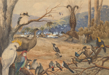 Benalla Art Gallery
Watercolour, Neville CAYLEY, Congress of the birds, 1910
... Clearing in a rural landscape with many different types of birds. There are palm trees and treed hills in the background. Stained timber...Benalla Art Gallery Benalla Art Gallery Benalla Botanical Gardens Bridge Street Benalla high-country Nationalism Watercolour Landscape Birds Magpie Cockatoo Kookaburra Blue Wren Rosella Field Tree recto: Signed and dated "Neville.W.Cayley -10-" in black watercolour in l.r.c of composition; Not titled Clearing in a rural landscape with many different types of birds. There are palm trees and treed hills in the background. Stained timber ...Born: Yamba, New South Wales, Australia 1886; Died: Sydney, New South Wales, Australia 1950NationalismLedger Gift, 1985Clearing in a rural landscape with many different types of birds. There are palm trees and treed hills in the background. Stained timber frame.recto: Signed and dated "Neville.W.Cayley -10-" in black watercolour in l.r.c of composition; Not titledwatercolour, landscape, birds, magpie, cockatoo, kookaburra, blue wren, rosella, field, tree -
 Wangaratta RSL Sub Branch
Print - Framed print
... Born 12 July 1907 Major Plains, Victoria Died 2 July 1993 (aged 85) Service/branch Australian Army Years of service 1935–1946 Rank Colonel Unit Royal Australian Army Medical Corps 2/2nd Casualty Clearing Station Commands held No.1 Allied General Hospital Battles/wars World War II Battle of Greece North African Campaign Syria-Lebanon campaign South West Pacific New Guinea Campaign South East Asia Campaign Awards Companion of the Order of Australia Knight Bachelor Companion of the Order of St Michael and St George Officer of the Order of the British Empire Knight of the Venerable Order of Saint John Mentioned in Despatches colonel sir ernest edward dunlop "weary" dunlop surgeon Sir Edward "Weary" Dunlop - Anzac Day 1993 Print No 455 of 500 Black timber frame containing coloured caricature of saluting Army Officer with flag in background. ...Colonel Sir Ernest Edward "Weary" Dunlop, AC, CMG, OBE (12 July 1907 – 2 July 1993) was an Australian surgeon who was renowned for his leadership while being held prisoner by the Japanese during World War II. Born 12 July 1907 Major Plains, Victoria Died 2 July 1993 (aged 85) Service/branch Australian Army Years of service 1935–1946 Rank Colonel Unit Royal Australian Army Medical Corps 2/2nd Casualty Clearing Station Commands held No.1 Allied General Hospital Battles/wars World War II Battle of Greece North African Campaign Syria-Lebanon campaign South West Pacific New Guinea Campaign South East Asia Campaign Awards Companion of the Order of Australia Knight Bachelor Companion of the Order of St Michael and St George Officer of the Order of the British Empire Knight of the Venerable Order of Saint John Mentioned in Despatches Black timber frame containing coloured caricature of saluting Army Officer with flag in background.Sir Edward "Weary" Dunlop - Anzac Day 1993 Print No 455 of 500colonel sir ernest edward dunlop, "weary" dunlop, surgeon -
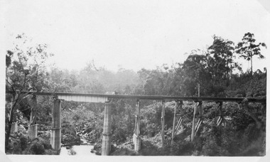 Lakes Entrance Historical Society
Photograph - Nowa Nowa Gorge. Nowa Nowa Victoria, 1925
... Black and white photograph of the rail bridge across the Nowa Nowa Gorge, showing two concrete pylons, and concrete and timber combined pylons set into the rocky terrain, clearing of trees is visible on steep sides of gorge, and dense timbered terrain in background. ...Lakes Entrance Historical Society 4 Marine Parade Lakes Entrance gippsland Transport Bridges Civil Engineering Topography Vegetation Black and white photograph of the rail bridge across the Nowa Nowa Gorge, showing two concrete pylons, and concrete and timber combined pylons set into the rocky terrain, clearing of trees is visible on steep sides of gorge, and dense timbered terrain in background. ...Black and white photograph of the rail bridge across the Nowa Nowa Gorge, showing two concrete pylons, and concrete and timber combined pylons set into the rocky terrain, clearing of trees is visible on steep sides of gorge, and dense timbered terrain in background. Nowa Nowa Victoriatransport, bridges, civil engineering, topography, vegetation