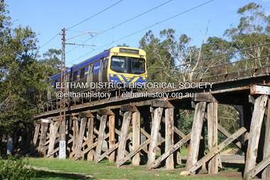
Showing 183 items matching "timber track"
-
 Marysville & District Historical Society
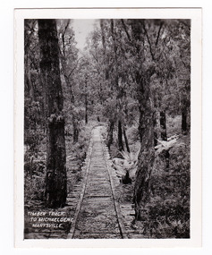
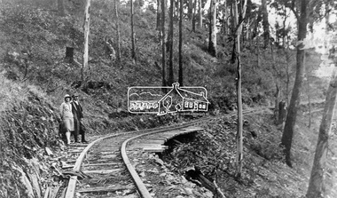
Photograph (item) - Black and white photograph, Timber Track to Michaeldene, Marysville, 1923-1963
... Timber Track to Michaeldene, Marysville...timber track...An early black and white photograph of an old timber track that leads to the Michaeldene track....An early black and white photograph of an old timber track that leads to the Michaeldene track. ...An early black and white photograph of an old timber track that leads to the Michaeldene track. ...An early black and white photograph of an old timber track that leads to the Michaeldene track.An early black and white photograph of an old timber track that leads to the Michaeldene track. The Michaeldene Walking Track is a popular walking track near Marysville in Victoria. Sections of this mostly flat circuit follow old tramline alignments, which in places reveal the original timber sleepers on which the big logs were transported to the nearby sawmill. This photograph was published by the Valentine Publishing Co. Pty. Ltd. as a souvenir of Marysville.timber track, michaeldene track, walking track, marysville, victoria, souvenir, timber tramway -
 Marysville & District Historical Society
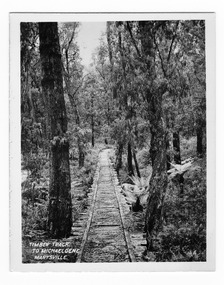
Photograph (item) - Black and white photograph, Valentine Publishing Co. Pty. Ltd, Timber Track to Michaeldene, Marysville, 1923-1963
... Timber Track to Michaeldene, Marysville...timber track...An early black and white photograph of an old timber track that leads to the Michaeldene track....An early black and white photograph of an old timber track that leads to the Michaeldene track. ...An early black and white photograph of an old timber track that leads to the Michaeldene track. ...An early black and white photograph of an old timber track that leads to the Michaeldene track.An early black and white photograph of an old timber track that leads to the Michaeldene track. The Michaeldene Walking Track is a popular walking track near Marysville in Victoria. Sections of this mostly flat circuit follow old tramline alignments, which in places reveal the original timber sleepers on which the big logs were transported to the nearby sawmill. This photograph was published by the Valentine Publishing Co. Pty. Ltd. as a souvenir of Marysville.timber track, michaeldene track, walking track, marysville, victoria, souvenir, timber tramway -
 Lorne Historical Society
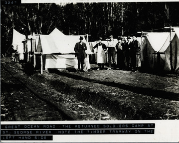
Photograph, The Returned Soldiers Camp at St. George River
... -George-River. Timber-Tramway-Track...-George-River. Timber-Tramway-Track Six workmen and cook? near tents at St George River Returned Soldiers' Camp. ...Six workmen and cook? near tents at St George River Returned Soldiers' Camp. Note timber tramway on left-hand side of photographreturned-soldiers-camp; st.-george-river. timber-tramway-track -
 Marysville & District Historical Society
Photograph (item) - Colour tinted photograph, Valentine Publishing Co. Pty. Ltd, Cumberland Falls, Marysville. No.3, 1923-1963
... track...timber milling...timber from trees destroyed in the 1939 bushfires. Cambarville was impacted by the 2009 Black Saturday bushfires and any remaining structures were destroyed. cumberland falls waterfalls marysville victoria valentine publishing co souvenir a cameron fj barton cambarville marysville-wood's point road eucalyptus regnans big culvert yarra track timber milling 1939 bushfires black saturday bushfires An early colour tinted photograph of the Cumberland Falls near Marysville in Victoria. ...An early colour tinted photograph of the Cumberland Falls near Marysville in Victoria. This photograph was published by the Valentine Publishing Co Pty. Ltd. as a souvenir of Marysville.An early colour tinted photograph of the Cumberland Falls near Marysville in Victoria. These falls are located on the Marysville-Wood's Point Road. Cambarville is notable for its giant mountain ash (Eucalyptus regnans) trees within the Cumberland Memorial Scenic Reserve, and relics from former sawmills and gold mining. The Big Culvert is located nearby on the Marysville-Woods Point Road, which was historically part of the Yarra Track. Cambarville was established as a timber mill town in the 1940s. Timber mill owners A Cameron and FJ Barton named Cambarville. They established the mill to salvage timber from trees destroyed in the 1939 bushfires. Cambarville was impacted by the 2009 Black Saturday bushfires and any remaining structures were destroyed.cumberland falls, waterfalls, marysville, victoria, valentine publishing co, souvenir, a cameron, fj barton, cambarville, marysville-wood's point road, eucalyptus regnans, big culvert, yarra track, timber milling, 1939 bushfires, black saturday bushfires -
 Marysville & District Historical Society
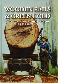
Book - Hardcover book, Peter Evans, Wooden Rails & Green Gold-A century of timber and transport along the Yarra Track, 2022
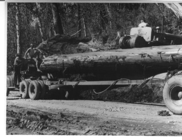
... Wooden Rails & Green Gold-A century of timber and transport along the Yarra Track......timber mills...yarra track...A history of the timber mills along the Yarra Track from Narbethong to Matlock...Marysville & District Historical Society 39 Darwin Street Marysville yarra-valley-and-the-dandenong-ranges A history of the timber mills along the Yarra Track from Narbethong to Matlock A history of the timber mills along the Yarra Track from Narbethong to Matlock timber timber mills yarra track narbethong matlock marysville wood's point wilks creek great divide cathedral range cumberland foresters sawmillers peter evans A history of the timber mills along the Yarra Track from Narbethong to Matlock. ...A history of the timber mills along the Yarra Track from Narbethong to Matlock.Hardcover. Shows Mick Taylor making last-minute adjustments to the rigging of a large log about to commence its journey down the incline to the Marysville Timber and Seasoning Company No.1 mill. Back cover has a photograph of a rail tractor towing a timber trolley along a timber tramway.non-fictionA history of the timber mills along the Yarra Track from Narbethong to Matlock.timber, timber mills, yarra track, narbethong, matlock, marysville, wood's point, wilks creek, great divide, cathedral range, cumberland, foresters, sawmillers, peter evans -
 Marysville & District Historical Society
Book - Hardcover book, Peter Evans, Wooden Rails & Green Gold-A century of timber and transport along the Yarra Track, 2022
... Wooden Rails & Green Gold-A century of timber and transport along the Yarra Track......timber mills...yarra track...A history of the timber mills along the Yarra Track from Narbethong to Matlock....A history of the timber mills along the Yarra Track from Narbethong to Matlock. timber timber mills yarra track narbethong matlock marysville wood's point wilks creek great divide cathedral range cumberland foresters sawmillers peter evans A history of the timber mills along the Yarra Track from Narbethong to Matlock. ...A history of the timber mills along the Yarra Track from Narbethong to Matlock.Hardcover. Shows Mick Taylor making last-minute adjustments to the rigging of a large log about to commence its journey down the incline to the Marysville Timber and Seasoning Company No.1 mill. Back cover has a photograph of a rail tractor towing a timber trolley along a timber tramway.non-fictionA history of the timber mills along the Yarra Track from Narbethong to Matlock.timber, timber mills, yarra track, narbethong, matlock, marysville, wood's point, wilks creek, great divide, cathedral range, cumberland, foresters, sawmillers, peter evans -
 Eltham District Historical Society Inc
Negative - Photograph, Timber Tramway at Wright's Falls, Kinglake District, c.1920
... Man and woman stand beside timber tramway track at Wright's falls Kinglake. The tramway was constructed alongside the road to support the large traffic in firewood between the mountains to Whittlesea. ...Eltham District Historical Society Inc 728 Main Rd Eltham melbourne Man and woman stand beside timber tramway track at Wright's falls Kinglake. The tramway was constructed alongside the road to support the large traffic in firewood between the mountains to Whittlesea. ...Man and woman stand beside timber tramway track at Wright's falls Kinglake. The tramway was constructed alongside the road to support the large traffic in firewood between the mountains to Whittlesea. The Wright family owned the land on which the Falls were situated and were sold for a penny an acre according to a Wright family story. This photo forms part of a collection of photographs gathered by the Shire of Eltham for their centenary project book,"Pioneers and Painters: 100 years of the Shire of Eltham" by Alan Marshall (1971). The collection of over 500 images is held in partnership between Eltham District Historical Society and Yarra Plenty Regional Library (Eltham Library) and is now formally known as 'The Shire of Eltham Pioneers Photograph Collection.' It is significant in being the first community sourced collection representing the places and people of the Shire's first one hundred years.Digital image 4 x 5 inch B&W Negshire of eltham pioneers photograph collection, kinglake, timber tramway, wrights falls -
 Melbourne Tram Museum
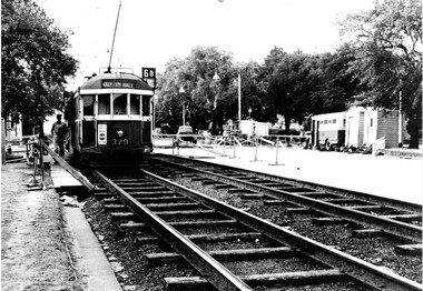
Photograph - Set of two Black & White Photograph/s, 1950's? to 1960's
... Black and white photograph of trams on temporary track in St Kilda Road, Melbourne, late 1950's or early 1960's. Shows timber sleepered track, temporary huts, a transport bus, air compressor and temporary barriers and kerosene lamps. .1 - W2 379 outbound on temporary track, destination of Malv Tn Hall (Malvern Town Hall) route 6B. .2 - W2 262, followed by 775 and two other trams. ...Melbourne Tram Museum 8 Wallen Road Hawthorn melbourne Trams tramways St Kilda Rd Temporary Track Reconstruction Malvern Town Hall Darling Rd tram 379 tram 262 tram 775 Stamped in black ink on back "TMSV Sales" Black and white photograph of trams on temporary track in St Kilda Road, Melbourne, late 1950's or early 1960's. Shows timber sleepered track, temporary huts, a transport bus, air compressor and temporary barriers and kerosene lamps. .1 - W2 379 outbound on temporary track, destination of Malv Tn Hall (Malvern Town Hall) route 6B. .2 - W2 262, followed by 775 and two other trams. ...Black and white photograph of trams on temporary track in St Kilda Road, Melbourne, late 1950's or early 1960's. Shows timber sleepered track, temporary huts, a transport bus, air compressor and temporary barriers and kerosene lamps. .1 - W2 379 outbound on temporary track, destination of Malv Tn Hall (Malvern Town Hall) route 6B. .2 - W2 262, followed by 775 and two other trams. W2 has the destination of East Malvern Darling Road, Route 4D. Printed on Fujichrome paper. Not known who took the photograph or when it was printed.Stamped in black ink on back "TMSV Sales"trams, tramways, st kilda rd, temporary track, reconstruction, malvern town hall, darling rd, tram 379, tram 262, tram 775 -
 Melbourne Tram Museum
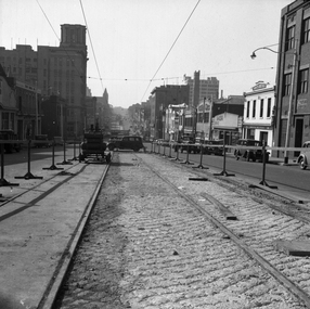
Negative - Set of 2, Possibly Geoff Grant, c1950
... Photo shoes the method of track construction - timber sleepers with the rail bolted to the sleeper. ...Photo shoes the method of track construction - timber sleepers with the rail bolted to the sleeper. ...Set of two Black and white negatives of track construction in La Trobe St during 1950. .1 - Looking east from Queen St. Has the Argus building in the view. Both tracks have been constructed and the concrete foundation poured pending the top asphalt layer, a building selling Skoda cars, .2 - Looking west from Queen St with a tram crossing in the background in William St. Photo shoes the method of track construction - timber sleepers with the rail bolted to the sleeper. Pending concerting. In the background is The Mint and terrace houses on the left. There is a billboard for 1949 movie, "The Bribe". Photo not in Wal Jack Melbourne album.trams, tramways, la trobe st, track construction, trackwork, queen st -
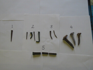 Parks Victoria - Gabo Island Lightstation
Nails
... Used to pin railway track to timber sleepers and decking on jetty. Rail track carried a small trolley used during the unloading of stores from supply ships. .5. ...Used to pin railway track to timber sleepers and decking on jetty. Rail track carried a small trolley used during the unloading of stores from supply ships. .5. ...The five types of nails include a stamped steel nail made for wooden flooring; four copper nails used for boat building found at various locations on the island; two steel nails removed from the lantern room door during restoration in 2002 which possibly came with the Chance Bros. lantern room kit delivered in 1862; three galvanised steel nails used to pin the railway track to sleepers and decking on the jetty (the rail track carried a small trolley for unloading stores from supply ships); and a square copper nail found on the rocky shore on Tullaberga Island close to the location of the Monumental City wreck of 1853. The huge American steamer, Monumental City, was wrecked on 15 May 1853. Built in 1850, the ship was the first screw-propulsion steamer to cross the Pacific and was heading back to Sydney after dropping off Californians heading for the Victorian goldfields. Thirty-seven lives were lost, including the owner of the ship, Peter Strobel. A medal was awarded by Sydney residents to Charles Plummer who swam ashore with a line from the wreck. The tragedy renewed the urgency for a lighthouse on Gabo Island, and in 1862 when this was achieved an obelisk was erected as a memorial to those who perished. That year, Victorian PWD architect and designer of the lightstation buildings, Charles Maplestone, gave the following instructions: ‘You may remove the remains of the poor unfortunate shipwrecked of the Monumental City to the site on Gabo you propose but take scrupulous care to collect all the remains and inter them decently under the monument. Pray save any relics’.246 Heritage Victoria has 39 artefacts listed under the Historic Shipwrecks Act (S473) with a clear provenance to the Monumental City. While the copper nail has no documented provenance, it still has contributory significance as part of a diverse assemblage of relics that help to interpret the history of the Gabo Island Lightstation and the numerous shipwrecks that have occurred in its vicinity since the mid nineteenth century..1 Steel nail - flat. Stamped. This type of nail was used for secret nailing of flooring. Source of this nail is unknown. .2 Copper nails. This type of nail was used for boat building. Found at various locations around island. .3 Steel nails. Extracted from lantern room door during restoration 2002. .4 Galvanised steel nails. Used to pin railway track to timber sleepers and decking on jetty. Rail track carried a small trolley used during the unloading of stores from supply ships. .5. Copper nail square. This nail was found on the rocky shore line on Tullaberga Island close to the location of the wreck of the "Monumental City" wrecked May 1853. Nail found in June 2000. -
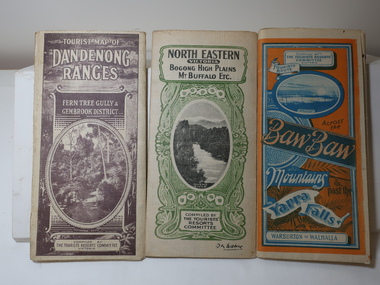 Kiewa Valley Historical Society
Maps - Tourist
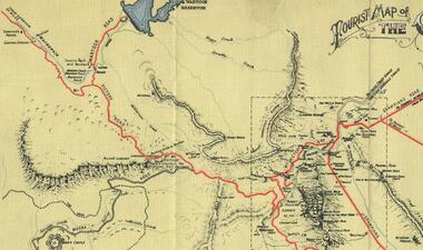
... Blue and Orange cover. dated 23-5-33 Govt. printer. 3 different maps of each area showin roads, tracks and timber tramways.Also in red and blue. 3. ...Blue and Orange cover. dated 23-5-33 Govt. printer. 3 different maps of each area showin roads, tracks and timber tramways.Also in red and blue. 3. ...These maps were all dated 1933 which was before the construction of the Kiewa Hydro Electric Scheme and when Tawonga was spelt Towonga. North East Victoria in 1933 was before the construction of the Kiewa Hydro Electric Scheme so the townships of Mt Beauty and Bogong are not shown. The description of the Snow Lines was important as skiers, bushwalkers and campers relied on them. The details on the map include "ADB. Numbered from A.1-377 round plates. CD Numbered from C 1-235 square plates. Poles about 3 chains apart 27 to the mile." 3 Tourist location maps (folded) and printed on parchment. 1. Tourist map of the Dandenong Ranges. Brown cover. dated 6-4-33. Govt. printer showing roads, tracks in red and heights of the land. 2. Tourist Map of Warburton, Mt Baw Baw, and Walhalla. Blue and Orange cover. dated 23-5-33 Govt. printer. 3 different maps of each area showin roads, tracks and timber tramways.Also in red and blue. 3. Tourist Map of North Eastern Victoria including Bogong High Plains Mt Buffalo Etc. Green cover. dated June 1933 Govt. printer. Main map and insert titled Bogong High Plains. Showing roads , tracks and tram ways. On insert showing snow poles. Also Red and Blue and mountains.By Authority of H.J. Green - 6 pence. Dept of Lands and Survey, Melbourne1933 maps, tourism maps, bogong high plains map 1933, snow poles -
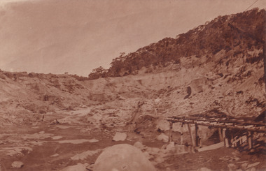 The Beechworth Burke Museum
Photograph, 1910
... The timber structure has rail tracks on top of the bridge which could suggest the identification of this structure as a mine entrance. ...The timber structure has rail tracks on top of the bridge which could suggest the identification of this structure as a mine entrance. ...This photograph dating to 1910 depicts an open cut sluicing site located in El Dorado captured looking east up the open cut from the number 3 Barge site. Sluicing was undertaken in the area from 1900 to 1942 with some short breaks between these periods. The image depicts a location mined by Cocks Pioneer Gold and Tin Sluicing Company (as recorded on the annotation on the card mount). It portrays open cut rocks with a crevice in the center of the image where the sluicing was being undertaken. There is a small timber structure on the right of the image which could be an entrance to a mine or supports made of wood to prevent a cave in at the open cut site and above the cut rock there is bush. The timber structure has rail tracks on top of the bridge which could suggest the identification of this structure as a mine entrance. The rail tracks were used for little carts which hauled soil from the mine. The Cocks Pioneer Gold and Tin Mines N.L was one of El Dorado's two largest open cut sluicing mines of the 20th Century. The other was named the Cocks El Dorado Gold Dredging Company. The Cocks Pioneer Mines operated from 1901 until 1941 and found a total of 117,378 ounces of Gold and 1,673 tones of tin concentrates over these years. The Cocks company was formed in 1898 and operated until 1941. Open cut sluicing involved the use of high-powered hoses which used the centrifugal sand pump system (known as hydraulic sluicing) which broke down the soil which was then processed for gold and other precious metals. From 1914 , four years after this image was captured, the company reformed to Cocks Pioneer Gold and Tin Mines NL (previously it was known as Cocks Pioneer Sluicing Co) and undertook large scale sluicing operations until 1929 and then 1934-1941. El Dorado is located on Reedy Creek and is surrounded by forested country to the north and east. It is 20 km east of Wangaratta in Victoria's regional north-east. John Cock was the son of a Cornish minor who arrived in El Dorado in 1858. Cock founded his gold and tin mining company which ran successfully for many years in the El Dorado region. It was an open cut sluicing company because of the abandonment of underground mining after this was deemed too dangerous. In 1935 Cock's El Dorado Company commissioned the floating dredge which is still visible in El Dorado today. The dredge was built by the Thompson engineering works, Castlemaine, and weighed over 2,000 tones and today has a place on the Victorian Registers of historic buildings. Interestingly, the name El Dorado does not derive from the gold in the region, but from the Barambogie pastoral run completed by William Baker in 1840-1841. Gold was discovered in El Dorado 1854 but the gold was too deep for individual prospectors to find, it required the use of heavy machinery.The search for gold is ingrained into the history of Victoria and therefore, images like this one which portray an open cut sluicing site can reveal important information for society and technology for the date when the photograph was taken. This image is of important historical significance for its ability to convey information about sluicing and the methods used to find gold in 1910. It also shows a location where sluicing was undertook which provides insight into the impact of sluicing on the environment at a time when it was done. This image is important for current research into the history of El Dorado, a small regional location near Wangaratta in Victoria's North East. Therefore, this image has the capacity to be beneficial for research into society and the motivations of those living and working in this region during this period and therefore, has social significance. The Beechworth Burke Museum has additional images relating to gold sluicing and El Dorado which can be analysed and studied alongside images like this one.Sepia coloured rectangular photograph printed on gloss photographic paper mounted on board.Obverse: COCKS PIONEER Q + T SL CO, N.L. / 1910 / LOOKING EAST UP OPEN CUT / FROM NO3 BARGE SITE / Reverse: 1997 . 2611 / A02611el dorado, north east gold, sluicing, gold sluicing, hydraulic sluicing, 1910, gold and tin mine, open cut mining, mining, gold mining, north-east victoria, beechworth, burke museum -
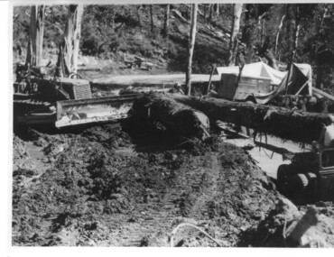 Kiewa Valley Historical Society
Photograph, logging at McKay Creek, Logging at McKay Creek, c1950's
... Excavation of this site did not commence until 1951 but road access(a narrow track) was provided in 1948 and widened in 1954. The logs would have been milled for timber at the State Electricity Commission's mill at Howman's Gap and thus provided a much needed source of timber for construction of camps and houses as there was a general of shortage of this commodity. ...Excavation of this site did not commence until 1951 but road access(a narrow track) was provided in 1948 and widened in 1954. The logs would have been milled for timber at the State Electricity Commission's mill at Howman's Gap and thus provided a much needed source of timber for construction of camps and houses as there was a general of shortage of this commodity. ...This photograph was probably taken at the site of McKay Creek Power Station. Excavation of this site did not commence until 1951 but road access(a narrow track) was provided in 1948 and widened in 1954. The logs would have been milled for timber at the State Electricity Commission's mill at Howman's Gap and thus provided a much needed source of timber for construction of camps and houses as there was a general of shortage of this commodity. Because of trouble with landslides in this area, a decision was made to place the machine hall of the power station underground instead of on the surface. Restricted financial resources and the repositioning of the power station retarded construction activities and it was not completed until early 1961.. An excellent pictorial record of the general working conditions, type of machinery and vehicles in use in the 1950/s.Black and white photograph showing logging equipment, fallen logs.Handwritten on the back of the photograph "Logging at McKay Creek)logging, mckay creek, timber, machinery -
 Kiewa Valley Historical Society
Photograph, logging at McKay Creek, Logging at McKay Creek, 1949/50
... track) was put it in 1948 and widened in 1954. The State Electricity Commission would have milled logs from this area at their mill at Howman's Gap. The timber...track) was put it in 1948 and widened in 1954. The State Electricity Commission would have milled logs from this area at their mill at Howman's Gap. The timber ...This photo was most likely taken at the site of the proposed McKay Creek Power Station. Excavation of this site was commenced in 1951 but an access road (a rough, narrow track) was put it in 1948 and widened in 1954. The State Electricity Commission would have milled logs from this area at their mill at Howman's Gap. The timber was used for building of housing and camps and provided a much needed resource as there was a general shortage of this commodity. The power station was relocated underground owing to repeated problems with landslides in the area. Restricted financial resources and the repositioning of the power station retarded construction activities and it was not completed until early 1961. An historical pictorial record of the type of machinery used in the 1950's - logging truck with bogie attached, the bull dozer and winch for hauling logs to the truck and note the lack of protective clothing!Black and white photograph showing a logging truck, bogie and bull dozer with winch for hauling the logs to the truck. Two men are on the truck, a driver on the bull dozer and a large log on the bogie. Hand written on the back of photo "Logging at McKay Creek".logging, mckay creek, timber, machinery -
 Port of Echuca
Coloured Photograph, 04/03/1984
... She has worked in the Wool Industry, the Timber Industry and the Tourist Industry. p.s. adelaide grassie, j.g port of echuca linklater, george poon boon station blair, david murray river darling river logging industry officer brothers. barmah forest fulton & shaw hutchinson, kevin murray downs station blackwood, adelaide On the orange front end loader are the numbers "5900" and the word "case." This is a coloured square photograph of an orange front end loader clearing a track ...The P.S Adelaide was launched on 21st July 1866. It was owned by J.G.Grassie from Poon Boon Station and the Officer Family of Murray Downs Station Swan Hill. The Adelaide was named after the niece of the Officer Bros, Adelaide Blackwood. The shipwright who built her was George Linklater. The Adelaide brought wool and passengers from the wool stations on the Murray and Darling Rivers down to the Echuca Wharf. In 1872 she was sold to David Blair & Sons. She was used to bring timber from the Barmah Forest to the Echuca Wharf. She did this work for the next 80 years. In 1953 she was tied up near the Mill and left. In 1958 she went to Paringa South Australia to work in the sawmill industry again. In 1960 the Echuca Apex Club and The Echuca Historical Society raised enough funds to buy the P.S. Adelaide and return her to Echuca. In November 1963 she was lifted out of the water and placed in Hopwood Gardens as this was thought to be a way of preserving her. In 1984 it was decided to return her to the water to resume work as a passenger vessel. In that time the Port of Echuca and the Echuca Wharf had been restored as a Tourist Precinct. This photograph shows the beginning of the task to return her to the river. It took several weeks in March 1984.The P.S Adelaide is extremely significant as it it the oldest known wooden hulled paddle steamers in the world. She was built in Echuca in 1866 and still operates on the Murray River today. She has worked in the Wool Industry, the Timber Industry and the Tourist Industry.This is a coloured square photograph of an orange front end loader clearing a track from Hopwood Gardens down to the river. The track was used to bring the P.S Adelaide from the gardens back into the river. The P.S Adelaide is in the background. The paddle steamer appears to be up on a trailer of some sort and is surrounded but plastic orange temporary fencing. There are small mounds of soil in the foreground.On the orange front end loader are the numbers "5900" and the word "case." p.s. adelaide, grassie, j.g, port of echuca, linklater, george, poon boon station, blair, david, murray river, darling river, logging industry, officer brothers., barmah forest, fulton & shaw, hutchinson, kevin, murray downs station, blackwood, adelaide -
 Bendigo Military Museum
Print - PRINT, FRAMED, AIF RACE MEETING
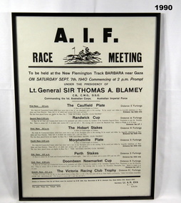
... Track, Barbara near Gaza dated Saturday Sept 7th, 1940. NB: this is a second display of same print. Print of poster - black print on white background. Frame - timber...Track, Barbara near Gaza dated Saturday Sept 7th, 1940. NB: this is a second display of same print. Print of poster - black print on white background. Frame - timber ...Print of a poster for race meeting " AIF Race Meeting" to be held on the New Flemington Track, Barbara near Gaza dated Saturday Sept 7th, 1940. NB: this is a second display of same print. Print of poster - black print on white background. Frame - timber, painted black colour. Glass front.On back of frame, on adhesive label, handwritten red ink. ON LOAN TO / BENDIGO RSL, AS LONG AS THEY/ WANT IT./ TO BE RETURNED/ IF DISPLAY OF PRINT NOT IN USE/ TO / N.S. FULLERTON/ 18 BOSQUET/ WHITE HILLS / OWNER.framed print, history, ww2, army -
 Bendigo Military Museum
Poster - POSTER, FRAMED, 'KOKODA'
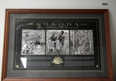
... track. Gold Rising Sun Badge below centre photo. printed information. Frame - brown stain timber with decorative moulding. ...track. Gold Rising Sun Badge below centre photo. printed information. Frame - brown stain timber with decorative moulding. ...Poster documents "Kokoda/Courage, Endurance, Mateship, Sacrifice" with headings " THE KOKODA LEGEND', THE KOKODA CAMPAIGN', THE FUZZY WUZZY ANGELS', THE BATTLE OF ISURAVA'. Poster - Gold and white print on black background, illustrated with three black and white photographs of scenes along the Kokoda Track, L-R Soldiers Resting. Fuzzy Wuzzy Angel assisting a wounded soldier. View of the ascending track. Gold Rising Sun Badge below centre photo. printed information. Frame - brown stain timber with decorative moulding. Dark grey with outline of cream colour cardboard mount. Glass front.photography-photographs, frame accessories, military history, ww2, kokoda -
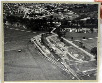 Orbost & District Historical Society
aerial photograph, 1970's
... timber and farming produce. In the early days of the railway's operation dedicated passenger trains ran but these ceased by the 1930s. The line was completely closed to freightage in 1987.The track infrastructure was dismantled in 1994 and has been redeveloped as the East Gippsland Rail Trail. railway photography orbost railway photography orbost A large black and white aerial photograph of Orbost Railway Station in the foreground and the Orbost township in the background. ...This photograph was taken prior to the closure of the Orbost -Bairnsdale freight line in 1987.The Orbost-Bairnsdale railway initially played a crucial role in developing agricultural industries in Gippsland as well as tourism. It opened in 1916 and operated until 1987, principally carrying timber and farming produce. In the early days of the railway's operation dedicated passenger trains ran but these ceased by the 1930s. The line was completely closed to freightage in 1987.The track infrastructure was dismantled in 1994 and has been redeveloped as the East Gippsland Rail Trail.A large black and white aerial photograph of Orbost Railway Station in the foreground and the Orbost township in the background. It has been pasted onto a piece of Masonite. railway photography orbost, railway photography orbost -
 Federation University Historical Collection
Book, From Timber to Tourism: Exploring Place Attachment and Natural Area Values in the Otway Ranges, 1997
... Barker Library (top floor) Mount Helen goldfields university of ballarat school of business tourism Apollo bay otway national park michelle brown melinda gill clare kearns sarah mcEwing Renee Walder cape otway lighthouse point franklin residential estate harbour sand dune erosion great ocean road blanket bay maits rest walking track Spiral bound report From Timber to Tourism: Exploring Place Attachment and Natural Area Values in the Otway Ranges Book ...Spiral bound reportuniversity of ballarat, school of business, tourism, apollo bay, otway national park, michelle brown, melinda gill, clare kearns, sarah mcewing, renee walder, cape otway lighthouse, point franklin residential estate, harbour, sand dune erosion, great ocean road, blanket bay, maits rest walking track -
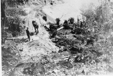 Upper Yarra Museum
Negative Photographic Reproduction, Building of tramway track
... track Upper Yarra Shire 1888-1988 Centenary collection. Negative, Black & white.Two men with horses digging earth with scoops and then tipping it over the side of the new embankment to make it wide enough for timber traffic to pass by....track Upper Yarra Shire 1888-1988 Centenary collection. Negative, Black & white.Two men with horses digging earth with scoops and then tipping it over the side of the new embankment to make it wide enough for timber traffic to pass by. ...03027 Photograph Building of tramway track Upper Yarra Shire 1888-1988 Centenary collection. Negative, Black & white.Two men with horses digging earth with scoops and then tipping it over the side of the new embankment to make it wide enough for timber traffic to pass by.building tramway track horse scraperscoop -
Alexandra Timber Tramway & Museum
Black and white photo, Rubicon tram track
... black and white photo of tram tracks in to bush these tracks were layed to harvest timber and build hyrdo power system .note wooden rails .man standing beside tree fern . in good cond...Alexandra Timber Tramway & Museum 17 Station Street Alexandra high-country rubicon tram tracks black and white photo of tram tracks in to bush these tracks were layed to harvest timber and build hyrdo power system .note wooden rails .man standing beside tree fern . in good cond Rubicon tram track Black and white photo ...black and white photo of tram tracks in to bush these tracks were layed to harvest timber and build hyrdo power system .note wooden rails .man standing beside tree fern . in good condrubicon tram tracks -
Alexandra Timber Tramway & Museum
Mr Sapsford, rubicon channel and tram tracks
... Alexandra Timber Tramway & Museum 17 Station Street Alexandra high-country Photograph of local event .Building of Rubicon power house ( station ) Detail of construction evedent in photo Un replaceable .record of local events rubicon channel and tram tracks rubicon photo of channel and tram tracks, put in to feed hydro system .note tree harvest and elevated channel to the right taken by mr sapsford of alexandra rubicon channel and tram tracks Mr Sapsford ...Photograph of local event .Building of Rubicon power house ( station ) Detail of construction evedent in photoUn replaceable .record of local eventsrubicon photo of channel and tram tracks, put in to feed hydro system .note tree harvest and elevated channel to the right taken by mr sapsford of alexandrarubicon channel and tram tracks -
Alexandra Timber Tramway & Museum
Rubicon black and white photo, rubicon Pipeline at Haulage at rubicon
... Alexandra Timber Tramway & Museum 17 Station Street Alexandra high-country rubicon Pipline up haulage rubicon rubicon pipeline at haulage at rubicon .Note tram tracks beside pipeline also men working on pipe with A frame .Mr Sapsford of Alexandra .In good cond rubicon Pipeline at Haulage at rubicon Rubicon black and white photo ...rubicon pipeline at haulage at rubicon .Note tram tracks beside pipeline also men working on pipe with A frame .Mr Sapsford of Alexandra .In good condrubicon Pipline up haulage rubicon -
Eltham District Historical Society Inc
Document - Folder, Standing, Bruce
... Contents Newspaper article: "Timber man recalls the good old days", Diamond Valley News, 31 May 1983. Bruce Standing's memories of his childhood. Bruce Standing St Andrew's school Bill Kreuger Butterman's Track Eddie Reardon E A Austin engineering Silk Brothers fruit merchants St Andrew's Hotel Ted Power Jack Reeves Smiths Gulley Newspaper clippings, A4 photocopies, etc Standing, Bruce Document Folder ...Bruce Standing grew up in St Andrew's and became a timber cutter, like his father. Contents Newspaper article: "Timber man recalls the good old days", Diamond Valley News, 31 May 1983. Bruce Standing's memories of his childhood. Newspaper clippings, A4 photocopies, etcbruce standing, st andrew's school, bill kreuger, butterman's track, eddie reardon, e a austin engineering, silk brothers fruit merchants, st andrew's hotel, ted power, jack reeves, smiths gulley -
 Waverley RSL Sub Branch
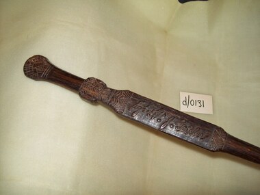
Carved Baton, Carved by a native
... track in Papua/New Guinea was the scene of fierce fighting during WWII. Australian troops halted the Japanese advance,turning defeat into victory. Mr Vic Geisler was a member of 39 battalion AIF during 1942.This baton was carved for him. kokoda baton native carved Sgt.V.J.Geisler A piece of timber carved as a baton. ...This baton was carved by a native at ower corner.The Kokoda track in Papua/New Guinea was the scene of fierce fighting during WWII. Australian troops halted the Japanese advance,turning defeat into victory.Mr Vic Geisler was a member of 39 battalion AIF during 1942.This baton was carved for him.A piece of timber carved as a baton. The handle has the name of Sgt.V.J.Geisler carved into it,and a hash type pattern around itSgt.V.J.Geislerkokoda, baton, native, carved -
 Eltham District Historical Society Inc
Photograph - Digital Photograph, Alan King, St Andrews Anglican Church, St Andrews, 30 January 2008
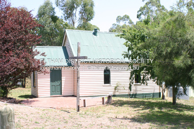
... Track. In 1882 the school was moved from a leased building, owned by headmaster Robert Harris, into a larger building on the corner of the School and the Heidelberg-Kinglake Roads. It had been moved from Smiths Gully and included a teacher’s three-roomed residence.7 In 1887 the school was replaced by the Queenstown State School No 128, although it was also called Caledonia Diggings until 1891. In 1956 it was renamed St Andrews. Still standing, this building is now used as the St Andrews Community Centre and the residence is leased for private use. The original timber...Track. In 1882 the school was moved from a leased building, owned by headmaster Robert Harris, into a larger building on the corner of the School and the Heidelberg-Kinglake Roads. It had been moved from Smiths Gully and included a teacher’s three-roomed residence.7 In 1887 the school was replaced by the Queenstown State School No 128, although it was also called Caledonia Diggings until 1891. In 1956 it was renamed St Andrews. Still standing, this building is now used as the St Andrews Community Centre and the residence is leased for private use. The original timber ...Built c.1868, St Andrew’s Anglican Church is Nillumbik Shire’s oldest timber church and is historically, socially, and spiritually significant to the Shire of Nillumbik. The church is historically significant because it may have given its name 'St Andrews' to the town (another suggestion is that the name came from the local hotel), it is also historically significant as one of only four buildings that remain from the Caledonian goldfields era of Queenstown (now St Andrews) and one of only a handful of buildings that survived the 1960s bushfires. The church is historically, socially, and spiritually significant because it has played an important part in community life for more than 150 years; a proposal to move the church in 1984 met with strenuous opposition. Much of the fires on Black Saturday 2009 were the north of the town. The town itself remained intact - as did this heritage building. Covered under Heritage Overlay, Nillumbik Planning Scheme. National Trust of Australia (Victoria) Local significance Published: Nillumbik Now and Then / Marguerite Marshall 2008; photographs Alan King with Marguerite Marshall.; p69 The St Andrews Anglican Church and former St Andrews Primary School, are two reminders of the district’s early days, when it was founded on gold. St Andrews, then called Queenstown, was the earliest goldfield in the Caledonia Diggings.1 It was the Upper Diamond Gold Mining and Administrative Centre, with 3000 miners. Queenstown was also the seat of the Court of Petty Sessions. The church and school then stood close to European and Chinese stores, three hotels, a brewery and a quartz mill.2 In 1861, Queenstown was officially proclaimed a township. From 1865, the name Queenstown was interchangeable with St Andrews, until 1952, when the town was officially named St Andrews. As gold declined from the early 1880s, Queenstown changed dramatically into a settlement of small farms. St Andrew’s Anglican Church, built in 1868, is the Shire’s oldest timber church and possibly gave its name to the township.3 The small timber church was opened on November 1, 1869, by the Dean of Melbourne. Anniversary tea meetings helped raise funds, and in 1889, a three-bedroom parsonage was built alongside. In 1910, the vicar, the Rev Selwyn Chase (and friend of the Scouting Movement’s founder, Baden Powell), established the 1st Queenstown Scout Troop, only two years after Scouting began in Australia. The church was important to the lives of many local residents who were baptised, married and had funeral services there. But by the 1950s the population had decreased and so did the weekly attendances. Around the mid-1960s the church closed, then fell into disrepair. So in the mid 1980s it was sold to the Education Department and was under threat of relocation or demolition. However this caused such opposition from locals,4 that instead, the Anglican church leased it as part of the Panton Hill parish5 and it was reconsecrated in 1987. Queenstown’s first school was held in a tent after transferring from Andersons Creek, Warrandyte.6 From 1858 a church school, Caledonia Diggings, stood west of the main road, a quarter of a mile (0.4km) before Buttermans Track. In 1882 the school was moved from a leased building, owned by headmaster Robert Harris, into a larger building on the corner of the School and the Heidelberg-Kinglake Roads. It had been moved from Smiths Gully and included a teacher’s three-roomed residence.7 In 1887 the school was replaced by the Queenstown State School No 128, although it was also called Caledonia Diggings until 1891. In 1956 it was renamed St Andrews. Still standing, this building is now used as the St Andrews Community Centre and the residence is leased for private use. The original timber-lined room remains alongside the extensions, and is distinctive with its high ceiling and tall small-paned windows. In 1984 a new school was built 500 metres west of the old school. Many residents have contributed much to St Andrews but one family that has done so for several generations is the Harris family. Robert Harris was an active member of the St Andrew’s Anglican Church, and worked hard at improving the town’s amenities until his death in 1887. He was a signatory to the successful 1863 petition to the Chief Commissioner of Police, against the proposed removal of the Court of Petty Sessions and police station at the Caledonia Diggings. The police station stayed in the town until 1917. Harris was Head Teacher of Queenstown State School from 1864 to 1874, then of the Smiths Gully school until it closed in 1882, and he continued teaching at Panton Hill until his death. His son, Robert Charles Harris, was editor and printer of the local newspaper, The Evelyn Observer, from 1873 until 1915. Robert’s son, William Shelley Harris, served in the Boer War and in World War One. In 1928 he became Kinglake National Park’s first park ranger. Robert’s daughter Elizabeth, taught needlework at Queenstown State School, and later ran the post office in Kinglake.This collection of almost 130 photos about places and people within the Shire of Nillumbik, an urban and rural municipality in Melbourne's north, contributes to an understanding of the history of the Shire. Published in 2008 immediately prior to the Black Saturday bushfires of February 7, 2009, it documents sites that were impacted, and in some cases destroyed by the fires. It includes photographs taken especially for the publication, creating a unique time capsule representing the Shire in the early 21st century. It remains the most recent comprehenesive publication devoted to the Shire's history connecting local residents to the past. nillumbik now and then (marshall-king) collection, st andrews, st andrews anglican church -
 Eltham District Historical Society Inc
Photograph - Digital Photograph, Alan King, Eltham Railway Trestle Bridge, 28 December 2007
... The 38 span single-track railway bridge over creek and road has 34 timber-beam spans and four steel-joist spans, supported by four-pile timber piers and timber abutments. ...The 38 span single-track railway bridge over creek and road has 34 timber-beam spans and four steel-joist spans, supported by four-pile timber piers and timber abutments. ...Covered under National Trust of Australia (Victoria) State Significance and Heritage Overlay, Nillumbik Planning Scheme. Published: Nillumbik Now and Then / Marguerite Marshall 2008; photographs Alan King with Marguerite Marshall.; p103 The Eltham railway trestle bridge is the only one of its kind still regularly used in Melbourne’s metropolitan railway network. Opened in 1902, it is also one of Victoria’s very few timber rail bridges that still carries trains.1 The bridge is part of the railway line extension from Heidelberg - extended to Hurstbridge in 1912. This extension resulted in one of the greatest social changes experienced in Eltham Shire, as it considerably lessened its isolation attracting tourists, artists and suburban commuters particularly after World War Two.2 The bridge has been classified by the National Trust as historically, scientifically, aesthetically and socially significant at state level. But this has not always been recognised, and in 1977, locals fought to save it from destruction. The Victorian Railways proposed to replace the bridge with an earth embankment and large culverts to avoid maintenance problems and fire. This was rejected by the Eltham Council who protested that the bridge helped maintain the area’s rural character, historic link and beauty, as well as avoiding possible serious flooding on the flood plain if a culvert was blocked. The bridge stands as part of a National Trust classified landscape which includes the Alistair Knox Park, named after the local conservationist and architect who helped to make Eltham famous for its mud-brick houses. The landscape includes tall and spreading manna gums and candlebarks, and the historic Shillinglaw Cottage. Artist Walter Withers, one of the Heidelberg School of painters, painted the bridge early in the 20th century. The 38 span single-track railway bridge over creek and road has 34 timber-beam spans and four steel-joist spans, supported by four-pile timber piers and timber abutments. It has almost 200m of timber deck. All of the timbers have been replaced over the years, but the only change to the bridge’s character was the addition of pylons and wiring for electric trains in 1923. A petition for a railway to the shire was first made in 1883. A large deputation of local citizens to the Commissioner of Railways proposed a route passing through Alphington to midway between Greensborough and Eltham up the Diamond Creek valley towards Queenstown and Kinglake. As a result the Princes Bridge-Heidelberg Railway was opened in 1888. From 1888 locals demanded a railway extension. Kangaroo Ground farmers in particular, led by Shire Councillor and Member for Evelyn, Ewen Cameron, said it would assist local farmers and orchardists send their produce to the Melbourne market. In 1890, before the severe economic Depression, an extension of the line to Hurst’s Bridge (now Hurstbridge) was included in a new Railways Bill. The parliamentary delegations were regaled with a banquet at Hurst’s barn and entertained by the Diamond Creek Brass Band, but the extension was abandoned when the Depression struck in 1892-1893. The extension of the railway to Eltham, completed in 1902, was one of the few built in those hard times. That is why the Eltham timber-trestle railway bridge is a rare example of a broad-gauge rail bridge constructed between 1893 and 1910. At the opening, despite persistent drizzle, 300 children waving flags and banners were among the large crowd welcoming the first train, carrying official dignitaries, to Eltham. It had taken 24 years to bring the railway to Eltham. From then Eltham became a popular destination for outings. Mr Orford of Eltham recalled that after the railway came to Eltham ‘the craze for picnics on weekends and holidays began…. During the wattle season, wattle trains came to Eltham frequently. The visitors roamed the creek pulling great armfuls of wattle blossom to take back with them to Melbourne’.3 In 1926 the railway line was electrified as part of the metropolitan rail network. But the Victorian Railways decided not to complete the formerly planned Diamond Valley Railway to Queenstown (now St Andrews) and Kinglake.This collection of almost 130 photos about places and people within the Shire of Nillumbik, an urban and rural municipality in Melbourne's north, contributes to an understanding of the history of the Shire. Published in 2008 immediately prior to the Black Saturday bushfires of February 7, 2009, it documents sites that were impacted, and in some cases destroyed by the fires. It includes photographs taken especially for the publication, creating a unique time capsule representing the Shire in the early 21st century. It remains the most recent comprehenesive publication devoted to the Shire's history connecting local residents to the past. nillumbik now and then (marshall-king) collection, eltham railway trestle bridge, eltham trestle bridge -
 Eltham District Historical Society Inc
Photograph - Digital Photograph, Alan King, Kinglake National Park, 27 March 2008
... However, before long, the accessible timber supply ran out, so in the 1920s agriculture took over – particularly potatoes and berry fruits – which involved large-scale clearing.2 The park’s instigator was retired Melbourne University Professor of Music, William Laver.3 As chair of the Kinglake Progress Association he began negotiations to have crown lands on the southern scarp of the Great Dividing Range reserved as a national park. Even before the park was proclaimed, from 1927, KPA members cut tracks...However, before long, the accessible timber supply ran out, so in the 1920s agriculture took over – particularly potatoes and berry fruits – which involved large-scale clearing.2 The park’s instigator was retired Melbourne University Professor of Music, William Laver.3 As chair of the Kinglake Progress Association he began negotiations to have crown lands on the southern scarp of the Great Dividing Range reserved as a national park. Even before the park was proclaimed, from 1927, KPA members cut tracks ...Fern gullies around Jehosaphat Gully Covered under National Estate. Published: Nillumbik Now and Then / Marguerite Marshall 2008; photographs Alan King with Marguerite Marshall.; p125 The magnificent Kinglake National Park, fringing Nillumbik’s north, is the largest national park close to Melbourne. Thanks to the vision and hard work of a band of local people, the park was created from what was rapidly becoming degraded land. Seeing a threat to Kinglake’s indigenous flora and fauna, several prominent local people campaigned for a national park, which was established in 1928.1 Since then, the park has grown through donations and acquisitions of land, from around 13,800 acres of land (5585ha) to 22,360 hectares. The Sugarloaf and Everard Blocks – of almost 8000 hectares – stand in Nillumbik and the park extends into Mitchell and Murrundindi Shires and the City of Whittlesea. Mt Everard commemorates William Hugh Everard, State member for Evelyn when the park was established. Before 1928, European settlers had degraded the Kinglake area, which was named after the celebrated English author and lawyer, Alexander William Kinglake. Remains of gold shafts and diggings in the park are reminders of Kinglake’s first settlers, who hoped to strike it rich at the gold diggings. But like other gold fields in this shire, they proved not very lucrative and soon timber cutting replaced mining in importance. However, before long, the accessible timber supply ran out, so in the 1920s agriculture took over – particularly potatoes and berry fruits – which involved large-scale clearing.2 The park’s instigator was retired Melbourne University Professor of Music, William Laver.3 As chair of the Kinglake Progress Association he began negotiations to have crown lands on the southern scarp of the Great Dividing Range reserved as a national park. Even before the park was proclaimed, from 1927, KPA members cut tracks to the major scenic points. Professor Laver was one of several people who gave land for the park, donating around 50 acres (20ha), including the Jehosaphat Gully.4 Laver chaired the park’s first Committee of Management, which raised money to employ a ranger and provide facilities, including tracks and roads for fire protection vehicles, toilets and shelters. The committee charged fees for firewood collection, some grazing of livestock, and visitor entrance, and obtained small State Government and Eltham Shire grants. In 1957 the State Government provided revenue for national parks. Then, in 1975, the State Government took over the management and the Committee of Management became an advisory committee, which disbanded in 1978. Originally, the park covered crown land in the Shires of Eltham and Whittlesea; then Wombelano Falls in Yea and other areas were added. In 1970 the park extended into the Shires of Eltham, Healesville, Whittlesea and Yea.5 Bush fires have been an ongoing problem. In 1939 hundreds of eucalypts and acacias had to be sown around the Jehosaphat Gully to rejuvenate the forest. To manage bushfires, the Committee of Management, then the State Government, worked closely with the Forestry Commission, shire councils and local fire brigades. Early national parks focussed on recreation. But by the 1980s, conservation, education and scientific research became more important, playing a vital role in preserving representative samples of the natural environment. Each year many thousands of people use the park’s extensive network of walking tracks amongst the protected plant and animal life as well as camping, cycling and horse riding. The park, along the slopes of the Great Dividing Range, has lookouts revealing magnificent views of the Melbourne skyline, Port Phillip Bay, the Yarra Valley and the You Yangs. Vegetation in the Masons Falls area includes messmate forest, Austral grass-trees, ferns and Hazel Pomaderris. In spring, orchids, lilies, everlasting daisies, correas, grevillea and heath appear. Around Jehosaphat Gully are wet and dry forest, fern gullies and banksia. Animal life includes wallabies, kangaroos, koalas, echidnas, possums, gliders and bandicoots. Male lyrebirds can be heard mimicking in the Jehosaphat Gully, particularly in the Everard Block in winter.This collection of almost 130 photos about places and people within the Shire of Nillumbik, an urban and rural municipality in Melbourne's north, contributes to an understanding of the history of the Shire. Published in 2008 immediately prior to the Black Saturday bushfires of February 7, 2009, it documents sites that were impacted, and in some cases destroyed by the fires. It includes photographs taken especially for the publication, creating a unique time capsule representing the Shire in the early 21st century. It remains the most recent comprehenesive publication devoted to the Shire's history connecting local residents to the past. nillumbik now and then (marshall-king) collection, kinglake national park, jehosaphat gully -
 Bendigo Historical Society Inc.
Slide - ALBERT RICHARDSON COLLECTION: NEW CHUM RAILWAY GOLD MINE
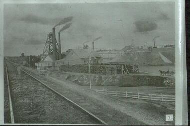
... Mine buildings on right hand side of track, chimneys, poppet head, horse and dray and large stacks of timber in foreground of image. ...Mine buildings on right hand side of track, chimneys, poppet head, horse and dray and large stacks of timber in foreground of image. ...Slide: railway track running alongside New Chum Mine, Breen Street, Golden Square, Bendigo. Mine buildings on right hand side of track, chimneys, poppet head, horse and dray and large stacks of timber in foreground of image. Boy standing on rail way line.number 1 in blackmine, gold, new chum railway, poppet heads, chimney stacks, timber stacks, 3 mine bridges, horse and dray, mining, bendigo, gold mining, railway line, new chum mine -
 Halls Gap & Grampians Historical Society
Map - Coloured
... McKeon's bullock team was known to have hauled red gum from the Valley to Stawell in the late 1870s and the 1880s. 1880s In 1887 an article in the Pleasant Creek news describes the Stony Creek Gorge track as "being a ledge alongside the mountain range, formed in the early days with the aid of earth and timber, along which the bullock teams used to travel to Horsham and plains of the Wimmera beyond." 1890s Gold was discovered in the catchment area of Stony Creek and by the end of the 1890s a new track was built from "near the junction of Fyan's and Stony Creeks, up the gorge to the diggings settlement. ...McKeon's bullock team was known to have hauled red gum from the Valley to Stawell in the late 1870s and the 1880s. 1880s In 1887 an article in the Pleasant Creek news describes the Stony Creek Gorge track as "being a ledge alongside the mountain range, formed in the early days with the aid of earth and timber, along which the bullock teams used to travel to Horsham and plains of the Wimmera beyond." 1890s Gold was discovered in the catchment area of Stony Creek and by the end of the 1890s a new track was built from "near the junction of Fyan's and Stony Creeks, up the gorge to the diggings settlement. ...Background on Bridle Path up Stony Creek Gorge Pre 1840 C. B. Hall, squatter on Mokepilly Run 1841-1842, first European to discover the Fyans Creek valley, the entrance of which became known as Hall's Gap. He later recorded that he followed a number of tracks which he assumed had been made by the Aboriginies and described one as "leading up a wild romantic glen and over on to the source of the Glenelg River". This could well have been the route taken up Stony Creek gorge by the first timber-cutters in this part of the Grampians to the saddle between the Wonderland and Mt. Difficult ranges known as Valley Gap 1850s/60s Timber cutters and shingle splitters were reported to be moving into the eastern side of the Grampians and by the mid 1860s there were a number of families connected to the supplying of timber to Pleasant Creek living in the "Hall's Gap ranges". John Wakeham, the first store owner in Pleasant Creek in 1854, established a timer-mill in upper Stony Creek Gorge in the late 1850s. Wakeham is credited for the clearing and levelling of the first bridle-path up the gorge. 1870s By the mid 1870s the track had been extended over Valley Gap to the Victoria Forest (the upper region of the Victoria Valley). McKeon's bullock team was known to have hauled red gum from the Valley to Stawell in the late 1870s and the 1880s. 1880s In 1887 an article in the Pleasant Creek news describes the Stony Creek Gorge track as "being a ledge alongside the mountain range, formed in the early days with the aid of earth and timber, along which the bullock teams used to travel to Horsham and plains of the Wimmera beyond." 1890s Gold was discovered in the catchment area of Stony Creek and by the end of the 1890s a new track was built from "near the junction of Fyan's and Stony Creeks, up the gorge to the diggings settlement. The mining Department had paid L300 for its construction and, when completed, the track was "three miles and 30 chains in length, the side cuttings at the narrowest part being 10 feet between" and "the watercourses which cross the track at various points" having been "filled up with rocks rolled down the sides of the hills, and consequently there can be no damage caused by bushfires which destroyed the former wooden bridges erected on the old track to Wakeham's saw-mill, the remains of which are still to be seen at the side of the diggings" The article goes on to further describe the track as one which "can with ease travel with a two horse conveyance either up or down" and that the workmen engaged in the construction of the track would be attending "a ball that night at McKeon's farm near the mouth of the gap to celebrate the successful completion of the undertaking". 1900s At what time the bridle path was extended beyond Valley Gap to the Wartook basin on the Mt. Difficult Range has not yet been determined. However, it is known that, by the turn of the century, people were travelling between Halls Gap and the caretakers' residence at Wartook Reservoir along what was now known as the "Bluff Road. Wartook's embankment had been constructed in 1887 and at that time there was already a track from Rosebrook Station homestead (near the present day Wartook Pottery) to the reservoir. Philip Rose owned both Rosebrook and Wartook Stations from the mid 1840s to the late 1850s and had regularly leased the Wartook basin to Cobb & Co. to rest horses there. 1920s Following the war of 1914-1918, tourism really took off in the Grampians, and Halls Gap rapidly grew. People would travel as far as they could on the many tracks then hike to the many lookouts being discovered by local tour guides. This led to the need for access across the range so that horse riders and the increasing number of vehicles could travel between Horsham and Halls Gap. To this end, the Bluff Road was improved and extended on 1929 and at its opening in March, 1930, by Lady Somers it was renamed the Mt. Victory Road.Map of Mt Victory Road and othersaccess routes, mt victory rd, bridle path, roads