Showing 9 items matching "tourello map"
-
 Clunes Museum
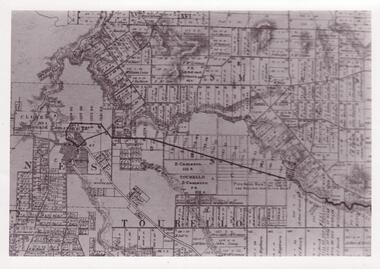
Map - MAP OF TOURELLO LAND HOLDINGS
... MAP OF TOURELLO LAND HOLDINGS......TOURELLO MAP...TWO COPIES OF AN EARLY MAP OF TOURELLO LAND HOLDINGS ONE COPY IS COPIED ON A 4 PAPER AND STUCK TOGETHER WITH STICKY TAPE...IT SEEMS TO BE CUT OFF A BIGGER MAP TOURELLO LAND HOLDINGS TOURELLO MAP TWO COPIES OF AN EARLY MAP OF TOURELLO LAND HOLDINGS ONE COPY IS COPIED ON A 4 PAPER AND STUCK TOGETHER WITH STICKY TAPE Map MAP OF TOURELLO LAND HOLDINGS ...THERE ARE NO NAMES, NO DATES. IT SEEMS TO BE CUT OFF A BIGGER MAPTWO COPIES OF AN EARLY MAP OF TOURELLO LAND HOLDINGS ONE COPY IS COPIED ON A 4 PAPER AND STUCK TOGETHER WITH STICKY TAPEtourello land holdings, tourello map -
 Federation University Historical Collection
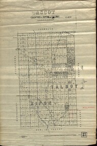
Plan - map, Ascot: Counties of Ripon and Talbot, 18/12/1920
... map...ascot...counties...e. c. sutherland...a. cameron...sweeney...w. j. clarke...mount hollowback...tourello..."L5270" parish map ascot counties e. c. sutherland a. cameron sweeney w. j. clarke mount hollowback tourello burrumbeet glendaruel dowling forest a. j. mullett w. j. butson 1920 william coghill chatham Chatham Family COllection Mrs E.C.Sutherland. ...Cadastral map showing parish boundaries and land ownership. "L5270"Maps parishes located in Ascot area. Photo-Lithographed at the Dept. of Lands and Survey.Highlighted parish labelled, Mrs E.C.Sutherland.parish, map, ascot, counties, e. c. sutherland, a. cameron, sweeney, w. j. clarke, mount hollowback, tourello, burrumbeet, glendaruel, dowling forest, a. j. mullett, w. j. butson, 1920, william coghill, chatham, chatham family collection, mrs e.c.sutherland. -
 Federation University Historical Collection
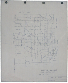
Map, Shire of Ballarat Road Location Map, 1968, 05/06/2014
... Barker Library (top floor) Mount Helen goldfields ballarat shire of ballarat roads dowling forest lake burumbeet lake learmonth ascot windermere tourello White paper road location map. Scale 1 mile to 1 inch Shire of Ballarat Road Location Map, 1968 Map Map ...White paper road location map. Scale 1 mile to 1 inchballarat, shire of ballarat, roads, dowling forest, lake burumbeet, lake learmonth, ascot, windermere, tourello -
Federation University Historical Collection
Map, Creswick Gold Field Map, 1981
... Barker Library (top floor) Mount Helen goldfields A fragment of the original 1880 map is also held in the collection. See 116 creswick krause surveyor smeaton spring hill tourello ascot dean bullarook gold fields gold Geologically and topographically surveyed by Ferdinand M Krause. ...A fragment of the original 1880 map is also held in the collection. See 116Rectangular geological map with brown paper strip on top edge with 4 holes on top edge. Scale is 40 chains to one inch.Geologically and topographically surveyed by Ferdinand M Krause. Lithographed by R. Shepherd. Printed by J. Finnie. Mining Department, Melbourne. Preprinted with additional shaft and lead detail. F. D. Atkinson, Government Printer 1981creswick, krause, surveyor, smeaton, spring hill, tourello, ascot, dean, bullarook, gold fields, gold -
 Federation University Historical Collection
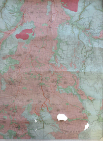
Map, Creswick, Clunes, Smeaton, Newstead, Yandoit and District, 1904, 06/1904
... map with green and pink predominating. The shows Ascot, Creswick, Clunes, Franklinford, Miners Rest, Sandon, Smeaton, Tourello, Yandoit...Barker Library (top floor) Mount Helen goldfields ascot creswick clunes franklinford miners rest sandon smeaton tourello yandoit mt moorookyle powlett's hill woodhouse's hill smeaton hill mcdonald's hill green hill spring hill horse shoe hill mt cameron strangways avoca forest stanley hunter j.w. gregory d. mcleod donald mcleod daruel A coloured geological map with green and pink predominating. ...A coloured geological map with green and pink predominating. The shows Ascot, Creswick, Clunes, Franklinford, Miners Rest, Sandon, Smeaton, Tourello, Yandoitascot, creswick, clunes, franklinford, miners rest, sandon, smeaton, tourello, yandoit, mt moorookyle, powlett's hill, woodhouse's hill, smeaton hill, mcdonald's hill, green hill, spring hill, horse shoe hill, mt cameron, strangways, avoca forest, stanley hunter, j.w. gregory, d. mcleod, donald mcleod, daruel -
 Federation University Historical Collection
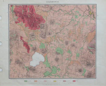
Map, Geological Map of Learmonth, 1882, 10/1882
... Barker Library (top floor) Mount Helen goldfields learmonth lake learmonth glendaruel burrumbeet mt blowhard morton's hill mt bolan addington mt cavern coghill's hill mt hollowback mt pisgah weatherboard hill webster's hill foster's hill mt bolen one mile hill vaughan's hill tourello stattion ballarat to maryborough railway saddleback hill ceres brown's hill ross's hill norman taylor robert burrows richard shephard james finnie Two copies: (printed noted attached) 3.) Rectangular geological map ...Two copies: (printed noted attached) 3.) Rectangular geological map edged in masking tape. Six colours define geology and are predominantly pink. Scale 40 chains to one inch .4) Notes referring to the Geological Map of Learmonth learmonth, lake learmonth, glendaruel, burrumbeet, mt blowhard, morton's hill, mt bolan, addington, mt cavern, coghill's hill, mt hollowback, mt pisgah, weatherboard hill, webster's hill, foster's hill, mt bolen, one mile hill, vaughan's hill, tourello stattion, ballarat to maryborough railway, saddleback hill, ceres, brown's hill, ross's hill, norman taylor, robert burrows, richard shephard, james finnie -
 Clunes Museum
Document - MAP
... Clunes Museum 36 Fraser Street enter building through Collins Place Clunes goldfields local history photography photographs water supply PHOTOCOPY OF CLUNES TOURELLO WATER SHED. Document MAP ...PHOTOCOPY OF CLUNES TOURELLO WATER SHED.local history, photography, photographs, water supply -
 Federation University Historical Collection
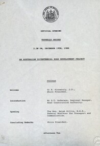
Document - Documents, Tourello: Opening of Tourello Bridge; Tourello Hunt Club, 1909; Tourello Tennis Club; Government Land Auction, 1855
... tourello bridge hunt club tennis club government land auctions talbot clunes coghill lenaghan peter lalor R. Kinnersly D.T. Anderson Ralph Willis Creswick Maps ...Maps and typed documentstourello bridge, hunt club, tennis club, government land auctions, talbot, clunes, coghill, lenaghan, peter lalor, r. kinnersly, d.t. anderson, ralph willis, creswick -
 Federation University Historical Collection
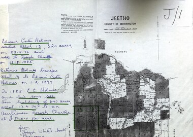
Map - Documents, Documents relating to Land - Selection of Maps of subdivisions; Titles; Cemetery sections
... Maps indicate the land owned in various areas of Victoria - Mornington Peninsula, Ascot / Creswick area jeetho county of mornington edward carter holmes joseph clarke catherine holmes talbot william coghill pre-emptive right tourello pre-emptive right glendonald pre-emptive right clunes smeaton ascot counties of ripon and talbot certificate of title ballaarat general cemetery new cemetery Poowong Helen Coghill Land maps showing block divisions and owners. ...Maps indicate the land owned in various areas of Victoria - Mornington Peninsula, Ascot / Creswick areaLand maps showing block divisions and owners. Edward Carter Holmes J.P. selected land and called it Launchley - later called Wambalano.jeetho, county of mornington, edward carter holmes, joseph clarke, catherine holmes, talbot, william coghill, pre-emptive right, tourello pre-emptive right, glendonald pre-emptive right, clunes, smeaton, ascot, counties of ripon and talbot, certificate of title, ballaarat general cemetery, new cemetery, poowong, helen coghill